Related Research Articles

Hume Highway, inclusive of the sections now known as Hume Freeway and Hume Motorway, is one of Australia's major inter-city national highways, running for 840 kilometres (520 mi) between Melbourne in the southwest and Sydney in the northeast. Upgrading of the route from Sydney's outskirts to Melbourne's outskirts to dual carriageway was completed on 7 August 2013.
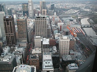
Hoddle Grid is the contemporary name given to the approximately 1-by-0.5-mile grid of streets that form the Melbourne central business district, Australia. Bounded by Flinders Street, Spring Street, La Trobe Street, and Spencer Street, it lies at an angle to the rest of the Melbourne suburban grid, and so is easily recognisable. It is named after the surveyor Robert Hoddle, who marked it out in 1837, establishing the first formal town plan. This grid of streets, laid out when there were only a few hundred settlers, became the nucleus for what is now Melbourne, a city of over five million people.

Proposals for expansion of the Melbourne rail network are commonly presented by political parties, government agencies, industry organisations and public transport advocacy groups. The extensions proposed take a variety of forms: electrification of existing routes to incorporate them into the suburban rail system; reconstruction of former passenger rail lines along pre-existing easements; entirely new routes intended to serve new areas with heavy rail or provide alternative routes in congested areas; or track amplification along existing routes to provide segregation of services. Other proposals are for the construction of new or relocated stations on existing lines, to provide improved access to public transport services.

Kalkallo is a suburb in Melbourne, Victoria, Australia, 31 km (19 mi) north of Melbourne's central business district, located within the City of Hume local government area. Kalkallo recorded a population of 5,548 at the 2021 census.
The Melbourne and Metropolitan Board of Works (MMBW) was a public utility board in Melbourne, Australia, set up in 1891 to provide water supply, sewerage and sewage treatment functions for the city. In 1992, the MMBW was merged with a number of smaller urban water authorities to form Melbourne Water. MMBW was abolished in 1992.

The Chandler Highway is a short road in the inner eastern suburbs of Melbourne. It runs from Heidelberg Road in Alphington, crosses the Yarra River, then continues across the Eastern Freeway, then terminates at an intersection with Princess Street and Earl Street. Its total length is less than 2 kilometres, leading to the claim that it is "the shortest highway in the world". It was named after a prominent local businessman and politician A. E. Chandler, who was instrumental in pushing through the development of the Outer Circle railway.
The Western Australian Planning Commission (WAPC) is an independent statutory authority of the Government of Western Australia that exists to coordinate strategic and statutory planning for future urban, rural, and regional land use. The WAPC fulfils various statutory responsibilities first established in 1955. The authority is responsible for expenditure arising from the Metropolitan Region Improvement Tax.
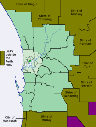
The Metropolitan Region Scheme (MRS) provides the legal basis for land use planning within the Perth metropolitan region. It classifies land into broad zones and reservations and is administered by the Western Australian Planning Commission. It is one of three regional schemes in Western Australia. The MRS is updated via an ongoing process of amendments. Amendments to the MRS are typically informed by a series of strategic plans prepared by the Department of Planning, Lands and Heritage. Detailed land use planning within the area of the MRS is undertaken by local governments and other statutory authorities which prepare one or more local planning schemes within their administrative boundaries. Local plannings schemes must be consistent with the MRS and require the approval of the WAPC. The acquisition of land reserved under the MRS is funded by a hypothecated land tax called the Metropolitan Region Improvement Tax.

Soldier settlement was the settlement of land throughout parts of Australia by returning discharged soldiers under soldier settlement schemes administered by state governments after World War I and World War II. The post-World War II settlements were co-ordinated by the Commonwealth Soldier Settlement Commission.
Activity centre is a term used in urban planning and design for a mixed-use urban area where there is a concentration of commercial and other land uses. For example, the central business districts of cities (CBD) are also known as “Central Activities Districts” (CAD) (also known as Downtown in North America or "Central Activities Zone" in the United Kingdom in recognition of the fact that commercial functions are not the only things that occur there. The term activity centre can also be used to designate an area for mixed-use development, whatever its current land use happens to be.
Yarra Bank Highway is a short urban highway in central Melbourne, Australia. It runs parallel to the Yarra River and provides an important alternate route to CityLink's Domain and Burnley Tunnels, used by trucks carrying hazardous loads prohibited from the tunnels, and provides another route when the tunnels are closed for maintenance. Prior to the construction of CityLink, the highway provided the main link between the Monash Freeway and the West Gate Freeway. It is known along its route as Power Street, City Road, Alexandra Avenue and Olympic Boulevard.

The 1969 Melbourne Transportation Plan was a road and rail transport plan for Melbourne, the state capital of Victoria, Australia, instituted by Henry Bolte's state government. Most prominently, the plan recommended the provision of an extensive freeway network, much of which has since been built.
The North East Link is an under construction 10–kilometre tolled highway scheme in Melbourne, Australia. Its stated objective is to connect the Metropolitan Ring Road at Greensborough with the Eastern Freeway at Bulleen, where the freeway would be upgraded from Hoddle Street to Springvale Road at Nunawading.

Melbourne is Australia's largest city and has a diverse and multicultural population.

The Transport Integration Act 2010 is a law enacted by the Parliament of the State of Victoria, Australia. The Act is the prime transport statute in Victoria, having replaced major parts of the Transport Act 1983, which was renamed as the Transport Act 1983.
The Metropolitan Town Planning Commission was created in 1922 by the Victorian state government to provide advice for the planning and development of the city of Melbourne, Australia. It produced the first comprehensive urban development strategy for Melbourne in 1929, and influenced future development for many years

Water management in Victoria deals with the management of water resources in and by the Australian State of Victoria.

The 1955 Plan for the Metropolitan Region, Perth and Fremantle was prepared for the Government of Western Australia by Gordon Stephenson and Alistair Hepburn. The plan was the first regional plan for Perth, and provided the basis for land use zoning under the Metropolitan Region Scheme. Even though not every recommendation of the report was adopted it is considered to have provided the underlying template for the modern development of Perth. The plan was superseded by the Corridor Plan for Perth in 1970.
References
- ↑ "Melbourne Metropolitan Planning Scheme 1954: Report". Department of Environment, Land, Water & Planning. 9 June 2023.
- ↑ Tsutsumi, Jun; Wyatt, Ray (2006). "A brief history of metropolitan planning in Melbourne, Australia". Applied GIS. 2 (2). doi:10.2104/ag060007.