
Hamersley is a residential suburb 14 kilometres north-northwest of the central business district of Perth, the capital of Western Australia, and six kilometres (4 mi) from the Indian Ocean. The suburb adjoins two major arterial roads—Mitchell Freeway to the west and Reid Highway to the south—and is within the City of Stirling local government area. It was built during the late 1960s and 1970s as part of the Government of Western Australia's response to rapidly increasing land prices across the metropolitan area.
The Kwinana Freeway is a 72-kilometre (45 mi) freeway in and beyond the southern suburbs of Perth, Western Australia, linking central Perth with Mandurah to the south. It is the central section of State Route 2, which continues north as Mitchell Freeway to Clarkson, and south as Forrest Highway towards Bunbury. A 4-kilometre (2.5 mi) section between Canning and Leach highways is also part of National Route 1. Along its route are interchanges with several major roads, including Roe Highway and Mandjoogoordap Drive. The northern terminus of the Kwinana Freeway is at the Narrows Bridge, which crosses the Swan River, and the southern terminus is at Pinjarra Road, east of Mandurah.

The Mandurah line is a commuter railway and service on the Transperth network in Western Australia that runs from Perth south to the state's second largest city Mandurah. The service is operated by Transperth Train Operations, a division of the Public Transport Authority. The line is 70.1 kilometres (43.6 mi) long and has 12 stations. At its northern end, the line begins as a continuation of the Joondalup line at Perth Underground, and ends as a continuation of the Joondalup line at Elizabeth Quay. The first 1.3 kilometres (0.81 mi) of the line is underground, passing under the Perth central business district. The line surfaces and enters the median of the Kwinana Freeway just north of the Swan River. It continues south down the freeway's median for 30 kilometres (19 mi), before veering south-west towards Rockingham. The final stretch of the line goes south from Rockingham to Mandurah.
Mitchell Freeway is a 36-kilometre-long (22 mi) freeway in the northern suburbs of Perth, Western Australia, linking central Perth with the city of Joondalup. It is the northern section of State Route 2, which continues south as Kwinana Freeway and Forrest Highway. Along its length are interchanges with several major roads, including Graham Farmer Freeway and Reid Highway. The southern terminus of the Mitchell Freeway is at the Narrows Bridge, which crosses the Swan River, and the northern terminus is at Hester Avenue, Clarkson, a suburb within the City of Wanneroo.

The Narrows Bridge is a freeway and railway crossing of the Swan River in Perth, Western Australia.

Roe Highway is a 35-kilometre-long (22 mi) limited-access highway and partial freeway in Perth, Western Australia, linking Kewdale with the city's north-eastern and south-western suburbs. The northern terminus is at Reid Highway and Great Northern Highway in Middle Swan, and the southern terminus is with Murdoch Drive at the Kwinana Freeway interchange in Bibra Lake. Roe Highway, in addition to Reid Highway, form State Route 3, a partial ring road around the outer suburbs of the Perth metropolitan area. Roe Highway also forms part of National Highway 94 from Great Eastern Highway Bypass to Great Eastern Highway, and National Highway 95 from Great Eastern Highway to Great Northern Highway.
Perth was established by Captain James Stirling in 1829 as the administrative centre of the Swan River Colony. It gained city status in 1856 and was promoted to the status of a Lord Mayorality in 1929. The city inherited its name due to the influence of Sir George Murray, then Member of Parliament for Perthshire and Secretary of State for War and the Colonies.
The Hamersley Development Scheme was conceived in 1967 and built over the ensuing years as part of a major effort by the Government of Western Australia to force down the price of land elsewhere in the Perth metropolitan area by opening up and developing land for housing as quickly as possible. This was a response to upward pressures on land prices across the metropolitan area, including demand created by the growth of the Kwinana industrial district south of Perth and the establishment of the iron ore industry in northern Western Australia. By 1968 land speculation had also become a significant factor, with individuals and companies profiting by buying and selling released but undeveloped land.

The Western Australian Planning Commission (WAPC) is an independent statutory authority of the Government of Western Australia that exists to coordinate strategic and statutory planning for future urban, rural and regional land use. The authority is responsible for expenditure arising from the Metropolitan Region Improvement Tax.
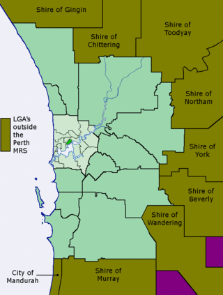
The Metropolitan Region Scheme (MRS) provides the legal basis for land use planning within the Perth metropolitan region. It classifies land into broad zones and reservations and is administered by the Western Australian Planning Commission. It is one of three regional schemes in Western Australia. The MRS is updated via an ongoing process of amendments. Amendments to the MRS are typically informed by a series of strategic plans prepared by the Department of Planning, Lands and Heritage. Detailed land use planning within the area of the MRS is undertaken by local governments and other statutory authorities which prepare one or more local planning schemes within their administrative boundaries. Local plannings schemes must be consistent with the MRS and require the approval of the WAPC. The acquisition of land reserved under the MRS is funded by a hypothecated land tax called the Metropolitan Region Improvement Tax.
Gordon Stephenson was a British-born town planner and architect. He is best known for his role in shaping the modern growth and development of Perth, Western Australia.
Transport in Perth, Western Australia, is served by various means, among them an extensive highway / freeway network and a substantial system of commuter rail lines and bus routes. Public transport is managed by the Transperth agency.

Paul Ritter was a Western Australian architect, town planner, sociologist, artist and author. In his roles as the first city planner of the City of Perth and subsequent two decades spent serving as Councillor for East Perth, Ritter is remembered as a brilliant, eccentric and often controversial public figure who consistently fought to preserve and enhance the character and vitality of the central city district. Today he is primarily remembered for his involvement in preserving many of Perth's heritage buildings at a time of rapid redevelopment and preventing the construction of an eight-lane freeway on the Swan River foreshore. Ritter's later career was blighted by a 3-year prison sentence for making misleading statements in applying for export marketing grants.

Cockburn Central is a suburb of Perth, the capital city of Western Australia, and is 24 kilometres (15 mi) south of Perth's central business district (CBD) along the Kwinana Freeway. Its local government area is the City of Cockburn, and it is intended by the Government to serve as a regional centre for the area. It was approved as a name by the Geographic Names Committee in 2007.
John Alistair Hepburn was a town planner, noted for his contributions to the design and development of the urban regions within greater Perth in Western Australia, and Melbourne, Victoria.
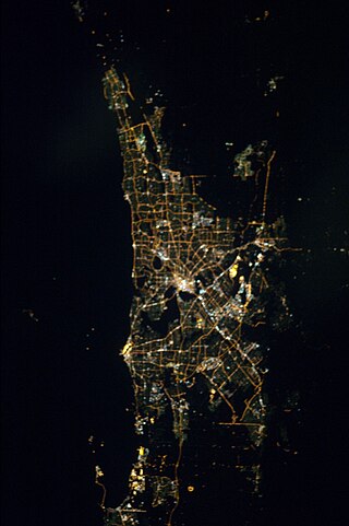
The Perth metropolitan region or the Perth metropolitan area is the administrative area and geographical extent of the Western Australian capital city of Perth and its conurbation.
The Fremantle Eastern Bypass was a proposed bypass of Fremantle, Western Australia, which would have linked Stirling Highway with Roe Highway. A highway link from Roe Highway to Fremantle Port was proposed in the Metropolitan Region Scheme since the 1950s. A reservation for the bypass was included in the scheme in 1973. It was deleted at the request of the state government's Minister for Planning in 1992, reinstated in 1994 following a change of government, and once more deleted in 2004 after another change of government in 2001.
Stephenson Avenue refers to two separate sections of road in the western suburbs of Perth, Western Australia.

Jandakot Regional Park is a conservation park approximately 20 kilometres (12 mi) south of Perth, Western Australia, located within the Cities of Armadale, Canning, Cockburn, Gosnells and Kwinana as well as the Shire of Serpentine-Jarrahdale. The park, established in 1997 as the Jandakot Botanic Park, covers a non-continuous area of 2,362 hectares and is managed by the Cities of Armadale, Cockburn and Kwinana. It stretches from the southern end of Jandakot Airport to south of Casuarina Prison.

The 1970 Corridor Plan for Perth provided a strategic framework for planning the growth of the metropolitan region of Perth, Western Australia. The plan superseded the 1955 Plan for the Metropolitan Region and established the principles on which the Metropolitan Regional Planning Authority would consider amendments to the Metropolitan Region Scheme. In contrast to the earlier plan, the Corridor Plan was not a detailed spatial plan of the entire metropolitan area. Instead it was intended to provide a policy framework for the detailed structure planning of each of the four proposed corridors. Initially it was controversial; the government of the day instigated both an independent review and an Honorary Royal Commission into the plan before adopting a modified version. A second review of the plan was completed in 1987, followed by the preparation and adoption of the 1990 Metroplan.
