Hamersley is a residential suburb 14 kilometres north-northwest of the central business district of Perth, the capital of Western Australia, and six kilometres (4 mi) from the Indian Ocean. The suburb adjoins two major arterial roads—Mitchell Freeway to the west and Reid Highway to the south—and is within the City of Stirling local government area. It was built during the late 1960s and 1970s as part of the Government of Western Australia's response to rapidly increasing land prices across the metropolitan area.

Western Australia (WA) is divided into regions according to a number of systems.

Joondalup is a suburb of Perth, Western Australia, approximately 26 kilometres (16 mi) north of Perth's central business district. It contains the central business district of the regional City of Joondalup and acts as the primary urban centre of Perth's outer northern suburbs.

Great Eastern Highway Bypass is a limited-access dual carriageway linking Great Eastern Highway and Roe Highway in Perth, Western Australia. Together with a section of Roe Highway, it bypasses the historical Guildford and Midland localities, through which the original, urban and slower Great Eastern Highway passes.
The Hamersley Development Scheme was conceived in 1967 and built over the ensuing years as part of a major effort by the Government of Western Australia to force down the price of land elsewhere in the Perth metropolitan area by opening up and developing land for housing as quickly as possible. This was a response to upward pressures on land prices across the metropolitan area, including demand created by the growth of the Kwinana industrial district south of Perth and the establishment of the iron ore industry in northern Western Australia. By 1968 land speculation had also become a significant factor, with individuals and companies profiting by buying and selling released but undeveloped land.
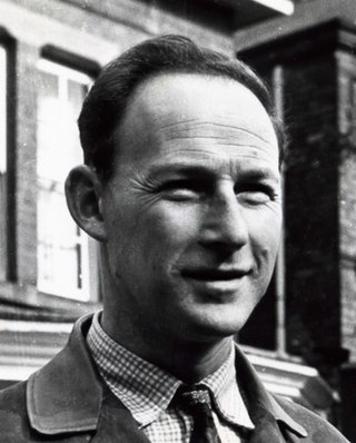
Gordon Stephenson was a British-born town planner and architect. He is best known for his role in shaping the modern growth and development of Perth, Western Australia.
The Town Planning and Development Act 1928 was an Act of the Western Australian Parliament which laid down specific controls over planning at a metropolitan and local level as well as establishing more general controls over the subdivision of land. The Act was based on earlier British legislation. It took 13 years for the Act to pass through the parliament. The Act formed the basis of the planning system of Western Australia into the early 21st century when the Act was repealed and replaced by the Planning and Development Act 2005. In 1929, Sydney-based planner David L. Davidson was appointed the first Town Planning Commissioner tasked with implementing the act.
Paul Ritter was a Western Australian architect, town planner, sociologist, artist and author. In his roles as the first city planner of the City of Perth and subsequent two decades spent serving as Councillor for East Perth, Ritter is remembered as a brilliant, eccentric and often controversial public figure who consistently fought to preserve and enhance the character and vitality of the central city district. Today he is primarily remembered for his involvement in preserving many of Perth's heritage buildings at a time of rapid redevelopment and preventing the construction of an eight-lane freeway on the Swan River foreshore. Ritter's later career was blighted by a 3-year prison sentence for making misleading statements in applying for export marketing grants.
John Alistair Hepburn was a town planner, noted for his contributions to the design and development of the urban regions within greater Perth in Western Australia, and Melbourne, Victoria.
The Fremantle Eastern Bypass was a proposed bypass of Fremantle, Western Australia, which would have linked Stirling Highway with Roe Highway. A highway link from Roe Highway to Fremantle Port was proposed in the Metropolitan Region Scheme since the 1950s. A reservation for the bypass was included in the scheme in 1973. It was deleted at the request of the state government's Minister for Planning in 1992, reinstated in 1994 following a change of government, and once more deleted in 2004 after another change of government in 2001.
William Albany "Bill" McKenzie AO was an Australian local government politician and public servant from Western Australia. He served as Mayor of Fremantle from 1972 to 1984, head of the Western Australian Planning Commission from 1985 to 1989, and Administrator of Christmas Island from 1990 until his death.
Stephenson Avenue refers to two separate sections of road in the western suburbs of Perth, Western Australia.

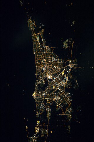
The 1955 Plan for the Metropolitan Region, Perth and Fremantle was prepared for the Government of Western Australia by Gordon Stephenson and Alistair Hepburn. The plan was the first regional plan for Perth, and provided the basis for land use zoning under the Metropolitan Region Scheme. Even though not every recommendation of the report was adopted it is considered to have provided the underlying template for the modern development of Perth. The plan was superseded by the Corridor Plan for Perth in 1970.

Jandakot Regional Park is a conservation park approximately 20 kilometres (12 mi) south of Perth, Western Australia, located within the Cities of Armadale, Canning, Cockburn, Gosnells and Kwinana as well as the Shire of Serpentine-Jarrahdale. The park, established in 1997 as the Jandakot Botanic Park, covers a non-continuous area of 2,362 hectares and is managed by the Cities of Armadale, Cockburn and Kwinana. It stretches from the southern end of Jandakot Airport to south of Casuarina Prison.
The Melbourme Metropolitan Planning Scheme 1954 was prepared for the Government of Victoria by the Melbourne and Metropolitan Board of Works. The scheme was approved in 1958 by the Board of Works, but did not become legally enforceable until 1968 when it was gazetted by the Minister for Local Government. The report recommended, amongst other things, a system of broad land-use zoning, a network of freeways and bypasses, and the regional allocation of public open space. The scheme identified five district centres of Footscray, Preston, Box Hill, Moorabbin and Dandenong. Local government authorities prepared local planning schemes which were intended to align with the Metropolitan Scheme's broad zones, but which frequently did not.

The 1970 Corridor Plan for Perth provided a strategic framework for planning the growth of the metropolitan region of Perth, Western Australia. The plan superseded the 1955 Plan for the Metropolitan Region and established the principles on which the Metropolitan Regional Planning Authority would consider amendments to the Metropolitan Region Scheme. In contrast to the earlier plan, the Corridor Plan was not a detailed spatial plan of the entire metropolitan area. Instead it was intended to provide a policy framework for the detailed structure planning of each of the four proposed corridors. Initially it was controversial; the government of the day instigated both an independent review and an Honorary Royal Commission into the plan before adopting a modified version. A second review of the plan was completed in 1987, followed by the preparation and adoption of the 1990 Metroplan.

The railway passenger service between Perth and Fremantle was closed from 2 September 1979 to 29 July 1983 by the Charles Court government of Western Australia.