Saparua is an island east of Ambon Island in the Indonesian province of Maluku; the island of Haruku lies between Saparua and Ambon. The main port is in the south at Kota Saparua. The small and uninhabited island of Maolana is located near its southwestern side and Nusa Laut off its southeastern tip.

Ambon is the capital and largest city of the Indonesian province of Maluku. This city is also known as Ambon Manise, which means "beautiful" or "pretty" Ambon in the Ambonese language. It covers a land area of 359.45 km2, and had a population of 331,254 at the 2010 Census and 347,288 at the 2020 Census; the official estimate as at mid 2023 was 354,052. The city is divided into five administrative districts – namely Nusaniwe, Sirimau, Teluk Ambon, Baguala and Leitimur Selatan. Known as Indonesia's music city, Ambon became the first city in Southeast Asia to be recognised as the UNESCO City of Music in 2019.

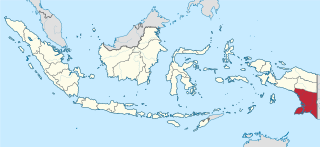
Maluku is a province of Indonesia. It comprises the central and southern regions of the Maluku Islands. The largest city and capital of Maluku province is Ambon on the small Ambon Island. It is directly adjacent to North Maluku, Southwest Papua, and West Papua in the north, Central Sulawesi, and Southeast Sulawesi in the west, Banda Sea, Australia, East Timor and East Nusa Tenggara in the south and Arafura Sea, Central Papua and South Papua in the east. The land area is 57803.81 km2, and the total population of this province at the 2010 census was 1,533,506 people, rising to 1,848,923 at the 2020 census, the official estimate as at mid 2023 was 1,908,753. Maluku is located in Eastern Indonesia.

Pattimura Airport is located in Ambon, Maluku province, Indonesia. The airport is located 38 kilometers west of the city of Ambon. The airport was named after Pattimura (1783–1817), an Indonesian national hero who fought against the Dutch colonialists in the nineteenth century. The airport serves domestic and international flights. Pattimura Airport Ambon is a very strategic area in the Maluku Islands which is divided into two provinces namely, North Maluku and Maluku.

The following is an alphabetical list of topics related to the Republic of Indonesia.
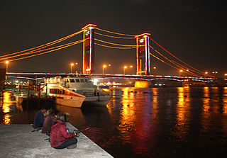
Ampera Bridge, formerly Bung Karno Bridge between its opening and the 1966 De-Sukarnoization campaign, is a vertical-lift bridge in the city of Palembang, South Sumatra, Indonesia. It connects Seberang Ulu and Seberang Ilir, two regions of Palembang. It can no longer be opened to allow ships to pass.
The Maluku sectarian conflict was a period of ethno-political conflict along religious lines that occurred in the Maluku Islands in Indonesia, with particularly serious disturbances on the islands of Ambon and Halmahera. The duration of the conflict is generally dated from the start of the Reformasi era in early 1999 to the signing of the Malino II Accord on 13 February 2002.

Martha Christina Tiahahu was a Moluccan freedom fighter and National Heroine of Indonesia.
Merah Putih is an Indonesian term for "red (and) white", it may refer to:

Port of Tanjung Perak is the second busiest sea port in Indonesia, located at Surabaya, East Java. It is the main port for the eastern part of the island of Java. The port is accessed from the North through the Madura Strait, a 25-mile (40-kilometer) long, 100-meter (110-yard) wide, and 9.5-meter (31-foot) deep channel between East Java and Madura Island. Because of its strategic position and the existence of surrounding advantageous hinterlands, the port constitutes the center of inter island shipping for Eastern Indonesia. Container terminal of the port is known as Terminal Petikemas. The port loaded and unloaded 3.55 million and 3.8 million TEUs of cargo during 2017 and 2018 respectively.

The Jatikramat River is a river in Bekasi, West Java, and the eastern part of the Special Capital Region of Jakarta, Indonesia. The lower portions of the original river have been channelized and directed into the eastern flood canal, "Banjir Kanal Timur", which continues to flow to the Java Sea in the district of Marunda, Cilincing, North Jakarta. The river regularly causes flooding in the city of Bekasi and Jakarta.
Cakung River is a river in the Bekasi, West Java, and the eastern part of the Special Capital Region of Jakarta, Indonesia. The lower portions of the original river have been channelized and directed into the eastern flood canal, "Banjir Kanal Timur", which continues to flow to the Java Sea in the district of Marunda, Cilincing, North Jakarta. The river regularly causes flooding in the cities of Bekasi and Jakarta.
The Buaran River is a river flowing in the Bekasi, West Java, and the eastern part of the Special Capital Region of Jakarta, Indonesia. The lower portions of the original river have been channelized and directed into the eastern flood canal, "Banjir Kanal Timur", which continues to flow to the Java Sea in the district of Marunda, Cilincing, North Jakarta. The river regularly causes flooding in the cities of Bekasi and Jakarta.
South Papua, officially the South Papua Province, is an Indonesian province located in the southern portion of Papua, following the borders of the Papuan customary region of Anim Ha. Formally established on 11 November 2022 and including the four most southern regencies that were previously part of the province of Papua and before 11 December 2002 had comprised a larger Merauke Regency, it covers a land area of 129,715.02 km2, about the same area as Pennsylvania. This area had a population of 513,617 at the 2020 Census, while the official estimate as at mid 2023 was 537,973, making it the least populous province in Indonesia.

The 2019 North Maluku earthquake, a shallow 7.2 magnitude earthquake, struck the island of Halmahera, North Maluku, Indonesia on 14 July 2019 at 18:10 local time with its epicentre located at South Halmahera. It struck at a shallow depth of 10 km (6.2 mi) near Labuha, a small port town located in Bacan Island. The earthquake produced a non-destructive 20 cm tsunami, which struck Labuha just minutes after the shaking started. 14 people were killed by the earthquake while 129 people were injured, and more than 50,000 people were displaced. The earthquake inflicted a total damage of Rp 238 billion.

On 26 September 2019, a strong magnitude 6.5 earthquake struck Seram Island in Maluku, Indonesia, near the provincial capital of Ambon. The earthquake struck at 07:46:44 Eastern Indonesia Time with a shallow depth of 18 km. The tremor could be felt throughout the island, with an intensity of very strong (VII) reportedly felt in the provincial capital of Ambon.

Ambon Bay is a bay that located in Ambon island, Maluku province, Indonesia. The bay separates Ambon island into two peninsulas; the southeastern and smaller peninsula is called Leitimur, while the larger northern peninsula is called Leihitu or Hitoe. These peninsulas are connected by a narrow neck of land on the eastern part of the island. The bay opens to the Banda Sea in the southwest direction. The Ambon Bay thus formed cuts about 20 kilometres into the island with the airport on the northern shore and the city of Ambon on the southern side. The city of Ambon covers the entirety of Leitimur, with its centre on the northwest coast of Leitimur, facing Leihitu, and has a safe harbor on Amboina Bay.

Tiakur is a kelurahan and the regency seat of Southwest Maluku Regency in Maluku, Indonesia. The town was purposely built as the capital of the Southwest Maluku Regency following its creation in 2008. It was created as the result of a political debate during the creation of the regency, although smaller than the larger and more developed town of the regency, Wonreli on Kisar Island. The town is located mainly within the boundaries of Tiakur kelurahan, with a population of 4,227 as of 2022.

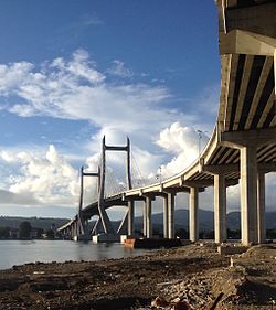
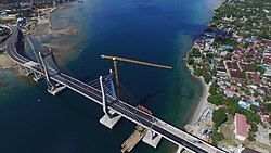
Kendari Bay Bridge is a cable-stayed bridge located in Kendari City, Southeast Sulawesi, Indonesia. It spans Kendari Bay, connecting Kendari District with Abeli District on the south side of the bay. This bridge was constructed by PP Construction & Investment and Nindya Karya, and was inaugurated by President Joko Widodo on October 22, 2020. The bridge is claimed to reduce travel time from the Old Town area of Kendari on the north side to the southern areas of Kendari, such as Bungkutoko Port and Poasia District, from approximately 25–30 minutes to 3–5 minutes.