Macapagal Bridge

Last updated

Macapagal Bridge

Tulay ng Macapagal
MacapagalBridge.jpg
Aerial and ground views of the bridge
Coordinates 8°55′21″N125°33′13″E / 8.92250°N 125.55361°E / 8.92250; 125.55361
Carries2 lanes of N951 (Philippines).svg N951 (Mayor Democrito D. Plaza II Avenue / Butuan Bypass Road); Pedestrians and vehicles
Crosses Agusan River
Locale Butuan, Agusan del Norte
Official namePresident Diosdado Macapagal Bridge
Other name(s)Second Magsaysay Bridge
Named for Diosdado Macapagal
Maintained by Department of Public Works and Highways
Characteristics
DesignSteel cable-stayed bridge
Total length908 m (2,979 ft) [1]
Longest span360 m (1,180 ft) [1]
No. of lanes Two-lane single carriageway
History
Constructed by Nippon Steel Corporation and TOA Corporation (Joint Venture)
Construction start2004
Construction end2007
Construction cost PH₱ 2.2 billion
Inaugurated2007
Location
Macapagal Bridge

Macapagal Bridge (Filipino: Tulay ng Macapagal) is a steel cable-stayed bridge along Mayor Democrito D. Plaza II Avenue (also known as the Butuan Bypass Road) in Butuan, Agusan del Norte that crosses the Agusan River. It has a length of 908 m (2,979 ft), making it the longest bridge in Mindanao, and the third-longest cable-stayed bridge in the Philippines after the Marcelo Fernan Bridge and Cebu-Cordova Bridge.

Contents

Initially named the "Second Magsaysay Bridge" during construction (referring to the nearby Magsaysay Bridge), the bridge was officially named after Philippine President Diosdado Macapagal when it was inaugurated in 2007. The bridge was constructed along with the 13.1 km (8.1 mi) Butuan Bypass Road, which aims to decongest traffic along the Agusan-Misamis Oriental Road in downtown Butuan, through official development assistance from the Japan Bank for International Cooperation worth PH₱2.2 billion.

Background

The old Magsaysay Bridge, built in 1957, was the only bridge spanning the Agusan River in Butuan before Macapagal Bridge was completed. Magsaysay Bridge (Full).jpg
The old Magsaysay Bridge, built in 1957, was the only bridge spanning the Agusan River in Butuan before Macapagal Bridge was completed.

Prior to the construction of the bridge, the nearby Magsaysay Bridge was the only bridge in Butuan that spans the Agusan River. Built in 1957, the old truss bridge has deteriorated over time and has experienced heavy traffic congestion because of the increasing vehicular volume in the city, thus necessitating the construction of a new bridge. [1]

Since the administration of Philippine President Fidel Ramos, there have been plans developed by the City Council for a bypass road and bridge that would alleviate the traffic problem along Magsaysay Bridge. During the administration of Philippine President Joseph Estrada, the development of a bypass road and bridge was included in his Mindanao 2000 Development Plan, which was part of his administration's effort to develop transportation infrastructure within the island. [1]

In August 2000, the Japan Bank for International Cooperation included the Second Magsaysay Bridge and the Butuan Bypass Road in its Special Yen (ODA) Loan Scheme worth JP¥ 34,723 million, along with the New Iloilo Airport Development Project and the Subic Bay Port Development Project. Of this loaned amount, JP¥ 3,549 million was allocated for the project. However, after President Estrada was removed from office during the 2001 EDSA Revolution, implementation of the project fell upon the newly installed administration of President Gloria Macapagal Arroyo. [1] [2]

Construction

The Macapagal Bridge, along with the Butuan Bypass Road, was constructed by a joint venture of Japanese engineering firms Nippon Steel Corporation and TOA Corporation, who were selected as main contractors after the loan agreement was signed. TOA Corporation was responsible for constructing the single main pylon made of reinforced concrete, the foundations to support the bridge superstructure, and all civil works for the road section. [3] A joint venture of Japanese firms Katahira and Engineers International and Sogo Engineering, Inc. and Filipino companies Proconsult, Inc., TCGI Engineers and DCCD Engineering provided the detailed engineering design and construction supervision for the project, including the preparation of conceptual and preliminary designs, detailed design, contract drawings, technical specification, cost estimates, and bid documents. [1] [4]

During the design phase of the project, the length of the main span was increased from 255 m (837 ft) to 360 m (1,180 ft) to prevent falling debris from clashing with the bridge piers in the event of heavy rains. This resulted in the reduction of the length of the approach bridge from 630 m (2,070 ft) to 548 m (1,798 ft), while the total length of the bridge was increased from 885 m (2,904 ft) to 908 m (2,979 ft) because abutments had to be built in a location away from the Agusan River to avoid the soft ground. [1]

Construction of the Macapagal Bridge and the Butuan Bypass Road was expected to last 70 months from the signing of the loan agreement in August 2000 up to the expected completion of civil works by May 2006. However, the actual construction took 82 months because of delays due to administrative procedures, delayed payment of billings for the contractors, flooding of the Agusan River due to inclement weather, delays in land acquisition and soft ground encountered near the bridge abutment, which required additional sub-surface investigations and design revisions. Civil works for both the bridge and the bypass road began in May 2004 and were completed in May 2007. [1]

Opening

The opening of Macapagal Bridge helped ease traffic congestion in Butuan and made transportation within the Caraga Region faster and more efficient. @ D. Macapagal Bridge - panoramio.jpg
The opening of Macapagal Bridge helped ease traffic congestion in Butuan and made transportation within the Caraga Region faster and more efficient.

Macapagal Bridge was completed and opened to traffic on the second week of April 2007. [5] Almost a month after, on May 3, 2007, the bridge was formally inaugurated during a ceremony led by Department of Public Works and Highways (DPWH) Secretary Manuel Bonoan, who represented President Arroyo. Also present during the inauguration are Akiri Sugiyama, economic minister of the Embassy of Japan in Manila, who represented Japanese Ambassador to the Philippines Ryuchiro Yamazaki; DPWH Assistant Secretary Rafael Yabut; Mindanao Economic Development Council Assistant Secretary Jose Aquino II; Japan Bank for International Cooperation (JBIC) chief representative Hiroshi Togo; Agusan del Norte First District Representative Leovigildo Banaag; and Japanese engineers from TOA Corporation, Nippon Steel Corporation and Katahira International. [6]

The bridge, which was initially named "Second Magsaysay Bridge" during construction after the nearby Magsaysay Bridge 3 km (1.9 mi) to the north, was officially named President Diosdado Macapagal Bridge more than three years after its inauguration, after President Arroyo signed Republic Act No. 10051 on March 19, 2010. [7] [8] [9] It's the third bridge named after former Philippine President Diosdado Macapagal after Macapagal Bridge in Cagayan de Oro and Macapagal Bridge in Marikina, Metro Manila.

Later history

Economic benefits

The Butuan Bypass Road which the bridge carries across the Agusan River was completed in 2011 and opened to vehicular traffic the following year. The road connects the Bancasi Airport along the Butuan-Cagayan de Oro-Iligan Road with the Surigao-Agusan-Davao Road and bypassing downtown Butuan, thus easing traffic congestion in the city, and in the Magsaysay Bridge, which has banned vehicles over 15 tons from passing over the bridge since 2008 due to its old age. With the opening of the Macapagal Bridge, travel time between Libertad and Tiniwisan districts of the city was reduced to 13 minutes. Traffic congestion along Magsaysay Bridge also eased, reducing travel time from 30 minutes to just 16.5 minutes after Macapagal Bridge opened. Overall, transportation of goods between Caraga Region and other regions in Mindanao became more efficient, resulting in an increase in residential and commercial development in areas along the bypass road and an increase in investments and employment opportunities in the city. [1] [5] [10]

Maintenance

The District Engineering Office (DEO) of Butuan under DPWH Region XIII was supposed to be in charge of operation and maintenance (O&M) for both the Macapagal Bridge and the Butuan Bypass Road. However, the responsibility for O&M was not delegated from DPWH Project Management Office - Philippine Japan Highway Loan (PMO-PJHL) to the DEO for six years after project completion. While no entity had the formal responsibility for O&M of the project, the DEO voluntarily conducted O&M to the extent possible. With the Butuan Bypass Road converted into a national road by virtue of Department Order No. 51 in May 2013, responsibility for O&M of the bridge and bypass road formally delegated to the DEO. [1]

The bridge had its first major rehabilitation in April 2010 after it was discovered in their routine inspection that the foundation of the bridge had been sinking deeper into the Agusan River due to the softening of the soils and rocks where the abutment was built. They feared that the bridge might sink deeper and eventually collapse if no rehabilitation works are immediately done. The rehabilitation work lasted 10 months, thereby forcing the City Council to order temporary closure of the bridge to traffic and rerouting of traffic to the old Magsaysay Bridge. [11]

Accidents and incidents

See also

Related Research Articles

<span class="mw-page-title-main">Mindanao</span> Island in the Philippines

Mindanao is the second-largest island in the Philippines, after Luzon, and seventh-most populous island in the world. Located in the southern region of the archipelago, the island is part of an island group of the same name that also includes its adjacent islands, notably the Sulu Archipelago. According to the 2020 census, Mindanao has a population of 26,252,442 people, while the entire island group has an estimated population of 27,021,036 according to the 2021 census.

<span class="mw-page-title-main">Agusan del Norte</span> Province in Caraga, Philippines

Agusan del Norte, officially the Province of Agusan del Norte, is a province in the Caraga region of the Philippines. Its capital is the city of Cabadbaran with several government offices located in the highly-urbanized city of Butuan. It is bordered on the northwest by Butuan Bay; northeast by Surigao del Norte; mid-east by Surigao del Sur; southeast by Agusan del Sur, and southwest by Misamis Oriental.

<span class="mw-page-title-main">Caraga</span> Administrative region of the Philippines

Caraga, officially the Caraga Administrative Region and designated as Region XIII, is an administrative region in the Philippines occupying the northeastern section of Mindanao. The region was created through Republic Act No. 7901 on February 23, 1995. The region comprises five provinces: Agusan del Norte, Agusan del Sur, Dinagat Islands, Surigao del Norte, and Surigao del Sur; six cities: Bayugan, Bislig, Butuan, Cabadbaran, Surigao and Tandag; 67 municipalities and 1,311 barangays. Butuan, the most urbanized city in Caraga, serves as the regional administrative center.

<span class="mw-page-title-main">Sibagat</span> Municipality in Agusan del Sur, Philippines

Sibagat, officially the Municipality of Sibagat, is a 1st class municipality in the province of Agusan del Sur, Philippines. According to the 2020 census, it has a population of 33,957 people.

<span class="mw-page-title-main">Butuan</span> Highly urbanized city in Agusan del Norte, Philippines

Butuan, officially the City of Butuan, is a 1st class highly urbanized city in the region of Caraga, Philippines. It is the de facto capital of the province of Agusan del Norte where it is geographically situated but has an administratively independent government. According to the 2020 census, it has a population of 372,910 people.

<span class="mw-page-title-main">Cabadbaran</span> Capital of Agusan del Norte, Philippines

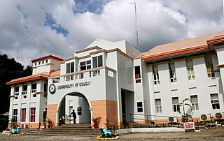
Cabadbaran, officially the City of Cabadbaran, is a sixth class component city and de jure capital of the province of Agusan del Norte, Philippines. According to the 2020 census, it has a population of 80,354 people.

<span class="mw-page-title-main">Magallanes, Agusan del Norte</span> Municipality in Agusan del Norte, Philippines

Magallanes, officially the Municipality of Magallanes, is a 4th class municipality in the province of Agusan del Norte, Philippines. According to the 2020 census, it has a population of 22,293 people.

<span class="mw-page-title-main">Bayugan</span> Component city in Agusan del Sur, Philippines

Bayugan, officially the City of Bayugan, is a 5th class component city in the province of Agusan del Sur, Philippines. According to the 2020 census, it has a population of 109,499 people..

<span class="mw-page-title-main">San Francisco, Agusan del Sur</span> Municipality in Agusan del Sur, Philippines

San Francisco, officially the Municipality of San Francisco, is a 1st class municipality in the province of Agusan del Sur, Philippines. According to the 2020 census, it has a population of 80,760 people.

<span class="mw-page-title-main">Pan-Philippine Highway</span> Highway in the Philippines traversing most of the country

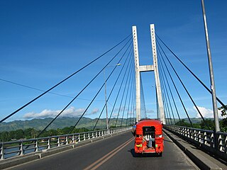
The Pan-Philippine Highway, also known as the Maharlika Highway, is a network of roads, expressways, bridges, and ferry services that connect the islands of Luzon, Samar, Leyte, and Mindanao in the Philippines, serving as the country's principal transport backbone. Measuring 3,379.73 kilometers (2,100.07 mi) long excluding sea routes not counted by highway milestones, it is the longest road in the Philippines that forms the country's north–south backbone component of National Route 1 (N1) of the Philippine highway network. The entire highway is designated as Asian Highway 26 (AH26) of the Asian Highway Network.

<span class="mw-page-title-main">Caraga State University</span> Public university in Agusan del Norte, Philippines

Caraga State University is a state-owned university in Agusan del Norte, Philippines. Its main campus is in Ampayon, Butuan with an auxiliary campus in Cabadbaran.

The Wawa River is a river located in Caraga, in northeastern Mindanao, in the southern Philippine island. Its headwaters traverse the municipality of Sibagat, Bayugan, and Esperanza. The Wawa River is a tributary of the larger Agusan River.

<span class="mw-page-title-main">Angelica Amante</span> Filipino politician

Maria Angelica Rosedell Malbas Amante-Matba, is a Filipino registered nurse and politician currently serving as the governor of Agusan del Norte, a position she previously held from 1995 to 2004 and from 2013 to 2019. She was also a member of the House of Representatives of the Philippines representing Agusan del Norte's 2nd congressional district.

The Surigao–Davao Coastal Road or the President Diosdado P. Macapagal Highway is a 677-kilometer (421 mi), two-to-six lane highway that connects the provinces of Surigao del Norte, Surigao del Sur, Davao Oriental, Compostela Valley, and Davao del Norte. It connects the Maharlika Highway in Placer, Surigao del Norte to the Agusan in Tagum. Running along the eastern coast of Mindanao, it is one of the longest roads in the Philippines.

<span class="mw-page-title-main">Butuan–Cagayan de Oro–Iligan Road</span>

The Butuan–Cagayan de Oro–Iligan Road, or Butuan–Cagayan de Oro–Iligan–Tukuran Road, is a 416-kilometer (258 mi), two-to-six lane major thoroughfare, connecting the provinces of Agusan del Norte, Misamis Oriental, Lanao del Norte, and Zamboanga del Sur.

<span class="mw-page-title-main">Mayor Democrito D. Plaza II Avenue</span> Road in the Philippines

Mayor Democrito D. Plaza II Avenue is a 15.5-kilometre (9.6 mi), two-to-four lane national secondary highway in Butuan. It serves as a diversion road from the Butuan–Cagayan de Oro–Iligan Road.

The Boguko River is a stream located in Sibagat, Agusan del Sur, Caraga Region, Philippines. It is a tributary of the larger Wawa River with headwaters located in the mountain boundaries of Sibagat and the Province of Surigao del Sur.

Guicam Bridge is a 1.2 km (0.75 mi) concrete girder bridge being planned for construction between the towns of Alicia and Mabuhay in Zamboanga Sibugay, Philippines. The bridge will connect Olutanga Island and its three municipalities of Mabuhay, Talusan, and Olutanga with the rest of Mindanao Island, which are separated by the Canalizo Strait. Once completed, it will be the longest bridge in Mindanao until the completion of the 3.77 km (2.34 mi) Panguil Bay Bridge between Tangub, Misamis Occidental and Tubod, Lanao del Norte.

<span class="mw-page-title-main">N9 highway</span> Road in Mindanao

National Route 9 (N9) is a 416-kilometer (258 mi), two to six major primary route network connecting the provinces of connecting the provinces of Agusan del Norte, Misamis Oriental, Lanao del Norte, and Zamboanga del Sur.

References

  1. 1 2 3 4 5 6 7 8 9 10 Tomita, Masami (2012). "Ex-Post Evaluation of Japanese ODA Loan Project" (PDF). Japan International Cooperation Agency . Retrieved January 12, 2018.
  2. "JBIC Extends Special Yen (ODA) Loan of 34,723 million yen to the Philippines". Japan International Cooperation Agency. August 31, 2000. Retrieved January 12, 2018.
  3. "Annual Report 2010" (PDF). TOA Corporation. Retrieved January 12, 2018.
  4. "Project Description: Diosdado Macapagal Bridge". DCCD Engineering Corporation. Retrieved January 12, 2018.
  5. 1 2 Guanzon, Alvin (January 30, 2007). "P2.2-B Butuan bridge opens April '07". GMA News Online . Retrieved January 12, 2018.
  6. Roperos, Robert (May 3, 2007). "DPWH chief leads launching of 2nd Magsaysay Bridge in Butuan". Philippine Information Agency . Retrieved January 12, 2018.
  7. "Republic Act No. 10051" (PDF). Senate of the Philippines . Retrieved January 12, 2018.
  8. "Republic Act No. 10051". The LawPhil Project. Retrieved January 12, 2018.
  9. "Republic Act No. 10051". Chan Robles Virtual Law Library. Retrieved January 12, 2018.
  10. Calo, Connie (April 30, 2011). "Butuan City by-pass road completed". Philippine Information Agency Caraga . Retrieved January 12, 2018.
  11. Serrano, Ben (April 5, 2010). "Newly-built Diosdado Macapagal Bridge in Butuan City up for rehab next month". balita.ph. Retrieved January 12, 2018.
  12. Morano, Jocelyn (July 14, 2009). "Thieves strip electrical wiring from Diosdado Macapagal Bridge". Philippine Information Agency . Retrieved January 12, 2018.
  13. Awitan, Charmane (February 19, 2012). "Son of DOTC director safe after jumping off bridge". ABS-CBN News . Retrieved January 12, 2018.