
Ladakh is a region administered by India as a union territory and constitutes an eastern portion of the larger Kashmir region that has been the subject of a dispute between India and Pakistan since 1947 and India and China since 1959. Ladakh is bordered by the Tibet Autonomous Region to the east, the Indian state of Himachal Pradesh to the south, both the Indian-administered union territory of Jammu and Kashmir and the Pakistan-administered Gilgit-Baltistan to the west, and the southwest corner of Xinjiang across the Karakoram Pass in the far north. It extends from the Siachen Glacier in the Karakoram range to the north to the main Great Himalayas to the south. The eastern end, consisting of the uninhabited Aksai Chin plains, is claimed by the Indian Government as part of Ladakh, but has been under Chinese control.

The Indian Astronomical Observatory (IAO) is a high-altitude astronomy station located in Hanle, India and operated by the Indian Institute of Astrophysics. Situated in the Western Himalayas at an elevation of 4,500 meters (14,764 ft), the IAO is one of the world's highest located sites for optical, infrared and gamma-ray telescopes. It is currently the tenth highest optical telescope in the world. It is India's first dark-sky preserve.
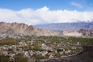
Leh district is a district in Indian-administered Ladakh in the disputed Kashmir-region. Ladakh is an Indian-administered union territory. With an area of 45,110 km2, it is the second largest district in the country, second only to Kutch. It is bounded on the north by Gilgit-Baltistan's Kharmang and Ghanche districts and Xinjiang's Kashgar Prefecture and Hotan Prefecture, to which it connects via the historic Karakoram Pass. Aksai Chin and Tibet are to the east, Kargil district to the west, and Lahul and Spiti to the south. The district headquarters is in Leh. It lies between 32 and 36 degree north latitude and 75 to 80 degree east longitude.

Ladakh has a long history with evidence of human settlement from as back as 9000 b.c. It has been a crossroad of high Asia for thousands of years and has seen many cultures, empires and technologies born in its neighbours. As a result of these developments Ladakh has imported many traditions and culture from its neighbours and combining them all gave rise to a unique tradition and culture of its own.

Ladakh is an administrative territory of India that has been under its control since 1947. The geographical region of Ladakh union territory is the highest altitude plateau region in India, incorporating parts of the Himalayan and Karakoram mountain ranges and the upper Indus River and valley.

Tourism is one of the economic contributors to the union territory of Ladakh in Northern India. The union territory is sandwiched between the Karakoram mountain range to the north and the Himalayas to the south, and is situated at a height of 11,400 ft. Ladakh is composed of Leh and Kargil districts. The region contains prominent Buddhist sites and has an ecotourism industry.

Tso Moriri or Lake Moriri or "Mountain Lake", is a lake in the Changthang Plateau in Leh district of the union territory of Ladakh in India. It is located approx. 219 km from Leh City, capital of Ladakh. The lake and surrounding area are protected as the Tso Moriri Wetland Conservation Reserve.
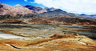
Rupshu is a high elevation plateau and valley and an eponymous community development block in southeast Ladakh. It is between the Startsapuk Tso and Tso Moriri, and west of Mahe.
Hanle is a large historic village in the Indian union territory of Ladakh. The revenue village of Hanle comprises six hamlets — Bhok, Dhado, Punguk, Khuldo, Naga and Tibetan Refugee habitation —within 1073 sq km Changthang Wildlife Sanctuary in Changthang plateau. It is the site of the 17th-century Hanle Monastery (gompa) of the Drukpa Kagyu branch of Tibetan Buddhism. Hanle is located in the Hanle River valley on an old branch of the ancient Ladakh–Tibet trade route. Hanle is the home of Hanle observatory, the tenth highest optical telescope in the world in India's first dark-sky preserve.
Chushul is a village in the Leh district of Ladakh, India. It is located in the Durbuk tehsil, in the area known as "Chushul Valley", south of the Pangong Lake and west of the Spanggur Lake. The Line of Actual Control with China runs about 5 miles east of Chushul, across the Chushul Valley. Famous as site for historical battle grounds.
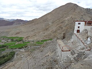
Nyoma is a principal village of southern Ladakh in India, the headquarters of an eponymous subdivision, tehsil, community development block and Indian Air Force Base in the Leh district. It is located on the bank of the Indus river after its 90-degree bend near Dungti east of Nyoma and before the valley narrows to a gorge near Mahe northwest of Nyoma. The Nyoma tehsil and subdivision cover all of southern Ladakh, including the Rupshu plains south of Nyoma, the Indus valley of Skakjung north of Nyoma, and the Hanle valley. Nyoma gompa, a Buddhist monastery, is located on the hill slope north of the village.
The National Large Solar Telescope (NLST) is a Gregorian multi-purpose open telescope proposed to be built in Merak village in Ladakh in India and aims to study the sun's microscopic structure.
Major Atmospheric Cerenkov Experiment Telescope (MACE) is an imaging atmospheric Cerenkov telescope (IACT) located near Hanle, Ladakh, India. It is the highest and second largest Cerenkov telescope in the world. It was built by Electronics Corporation of India, Hyderabad, for the Bhabha Atomic Research Centre and was assembled at the campus of Indian Astronomical Observatory at Hanle. It was originally scheduled to become operational by 2016, but plans were pushed back to begin operations in 2020. It will be remotely operated and will run on solar power.

The Tso Kar or Tsho kar is a fluctuating salt lake known for its size and depth situated in the Rupshu Plateau and valley in the southern part of Ladakh in India. It is also recognised as India's 42nd Ramsar site.

The Khurnak Fort is a ruined fort on the northern shore of Pangong Lake, which spans eastern Ladakh in India and Rutog County in the Tibet region of China. The area of the Khurnak Fort is disputed by India and China, and has been under Chinese administration since 1958.
Tangtse or Drangtse (Tibetan: བྲང་རྩེ, Wylie: brang rtse, THL: drang tsé) is a village in the Leh district of Ladakh, India. It is located in the Durbuk tehsil. Traditionally, it was regarded as the border between the Nubra region to the north and the Pangong region to the south. It was a key halting place on the trade route between Turkestan and Tibet. It was also a site of wars between Ladakh and Tibet.
Durbuk or Darbuk, is a village and the headquarters of the eponymous subdivision and block in the Leh district of Ladakh, India. It is located in the Durbuk tehsil, and falls between Chang La mountain pass and Tangste village on the way to Pangong Tso Lake.

University of Ladakh (UOL), aka Ladakh University, is a public university located in Leh in Leh district of Indian Union territory of Ladakh.
Phobrang is a settlement in the Indian union territory of Ladakh. It is near Lukung on the way the Indo-China border at the Hot Springs. It is the last village of Ladakh in this direction, at an elevation of 14,500 feet (4,400 m).
Kyagar Tso or Kyagar Lake is a small brackish lake surrounded by mountains situated in the Ladakh region of the northern Indian Union Territory of Ladakh in India. From afar, it can be spotted by its turquoise colour.


