Leh district

Last updated

Leh district
District of Ladakh administered by India [1]
Leh 02.jpg
View of Leh Town
Leh district
Interactive map of Leh district
Ladakh Leh district.svg
Location of Leh district in Ladakh
Coordinates(Leh): 33°38′N77°46′E / 33.633°N 77.767°E / 33.633; 77.767
Administering countryFlag of India.svg  India
Union Territory Flag of Ladakh, India.svg Ladakh
Headquarters Leh
Established1 July 1979
Headquarters Leh
Tehsils Leh, Khaltsi, Nyoma, Kharu, Diskit Nubra, Saspol, Durbuk and Sumoor
Government
   Deputy Commissioner Shrikant Balasaheb Suse, IAS
   Chief Executive Councillor Tashi Gyalson, BJP
   Lok Sabha Constituency Ladakh
   MP Jamyang Tsering Namgyal [2]
Area
  Total45,110 km2 (17,420 sq mi)
Population
 (2011)
  Total133,487 (2,011)
   Urban
45,671
Demographics
   Literacy 77.2%
   Sex ratio 690 / 1000
Languages
  Official Hindi and English
  Spoken Ladakhi, Purgi, Brokskat, Tibetan, Hindi/Urdu
Time zone UTC+05:30 (IST)
Vehicle registration LA-01
Website leh.nic.in

Leh district is a district in Indian-administered Ladakh in the disputed Kashmir-region. [1] Ladakh is an Indian-administered union territory. With an area of 45,110 km2, it is the second largest district in the country, second only to Kutch. It is bounded on the north by Gilgit-Baltistan's Kharmang and Ghanche districts and Xinjiang's Kashgar Prefecture and Hotan Prefecture, to which it connects via the historic Karakoram Pass. Aksai Chin and Tibet are to the east, Kargil district to the west, and Lahul and Spiti to the south. The district headquarters is in Leh. It lies between 32 and 36 degree north latitude and 75 to 80 degree east longitude.

Contents

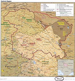
All of Ladakh was under the administration of Leh until 1 July 1979, when the Kargil and Leh administrative districts were created. Religion has been a source of grievance between Buddhists and Muslims since the late 20th century and contributed to this division. [3]

In 2017, the district was declared a tobacco-free zone. The Directorate of Health Services Kashmir, under the National Tobacco Control Programme, began working towards the designation early in 2017 and the status was declared in August. Rehana Kousar (in-charge, NTCP, Kashmir) said that work was done with civil society, religious and women's groups and that a "major success was achieved by the involvement of women in the anti-tobacco campaign." [4]

In August 2019, the Parliament of India passed the act that contained provisions to make Leh a district of the new union territory of Ladakh, which was formed 31 October 2019. [5]

Administration

Leh district has seven sub-divisions and twelve tehsils. The sub-divisions are: Nubra, Durbuk (Durbok), Khalatse (Khaltsi/Khalsi), Leh, Kharoo, Likir, Nyoma. The tehsils are: Sumoor,and Diskit in Nubra Valley, Durbuk, Khalatse, Saspol, Leh, Kharoo, and Nyoma. [6]

Leh district
Leh district in Ladakh

As a result of The Jammu and Kashmir Reorganisation (Removal of Difficulties) Second Order, 2019, Leh district claimed de jure jurisdiction over the following areas of Pakistani-administered Kashmir: Gilgit, Gilgit Wazarat, Chilas, and Tribal territory, [7] making it only slightly smaller than the country of Tunisia.

The Ladakh Autonomous Hill Development Council, Leh (LAHDC Leh) is the Autonomous District Council that administers the Leh district. [8]

As of July 2019, Leh district is divided into 7 sub-divisions (new sub-divisions in Leh), 12 tehsils (new tehsils in Panamik, Turtuk, Chuchot and Likir) and 18 new blocks in Sumoor and Likir (blocks). [9] [6]

Sub–divisions, Blocks and Villages in Leh [10]
DistrictSub-DivisionBlocksVillages
Leh district Khaltsi Khaltsi Kanji, Khaltsi, Lamayuru, Leh Dho, Nurla, Skindiang,Takmachik, Temisgam, Tia
Singaylalok Fotoksar, Lingshet, Wanla, Youl Chung
Skurbuchan Dah, Damkhar, Hanoo, Skur Buchan
Leh Chuchot Chuchot Yakma, Chuchot Gongma, Chuchot Shama, Mathoo, Stakna, Stok
Leh Phey, Saboo, Phyang, Spituk, Choglamsar
Thiksay Nang, Rambir Por, Shey, Thiksey
Nubra Diskit Diger, Disket, Hundar, Hundar Dok, Hundri, Khalsar, Khardong, Khema Khungru,Lakjung, Largiab, Partapur, Skanpuk, Skuru, Tangyar, Terchey, Udmaru, Warisfistan
Panamic Chamshan Charasa, Khemi, Kubed, Panamic, Sumoor, Tiggar
Turtuk Bogdang, Chulungkha, Taksi, Thanga Chathang, Turtok
Durbuk Durbuk Chushul, Durbuk, Kargyam, Man Pangong, Shachukul,Tangste
Kharu Kharu Changa, Chemday, Gia, Hemis, Igoo, Khargu,Langokor, Matselang, Miru, Phuktse, Serthi, Shang, Shara, Sharnose, Upshi
Likir Nimoo Bazgoo, Chiling Sumda, Likir, Ney, Nimoo, Rumbak, Skiumarkha, Taroo, Umla
Saspol Alchi, Giramangu, Saspochey, Suspol, Tarhipti, Hemishok Pachan
Nyoma Nyoma Anlay, Demjok, Koyul, Mood, Nyoma
Rong-Chumathang Chumathang, Himya, Kerey, Kumgyam, Liktse, Skitmang, Tarchit, Teri, Leh, Tukla
Rupsho-Puga Karzok, Kharnak, Samad Rakchan
Total716113

Demographics

Sex Ratio in Leh District in 2011 Census. [11]
(no. females per 1,000 males)
Religion (and population)Sex Ratio
Buddhist (pop 88,635)
1,014
Hindu (pop 22,882)
942
Muslim (pop 19,057)
816
Other (pop 2,913)
165
Total (pop 133,487)
690

According to the 2011 census Leh district had a population of 133,487, [12] roughly equal to the nation of Saint Lucia. [13] This gives it a ranking of 609th in India (out of a total of 640).[ citation needed ] The district has a population density of 3 inhabitants per square kilometre (7.8/sq mi). Its population growth rate over the decade 2001-2011 was 13.87%, (it was 30.15% for 1991–2001).[ citation needed ] Leh has a sex ratio of 690 females for every 1000 males (this varies with religion), and a literacy rate of 77.2%.[ citation needed ]

Religion

Religion in Leh district (2011) [11]
ReligionPercent(%)
Buddhism
66.40%
Hinduism
17.14%
Islam
14.28%
Sikhism
0.82%
Other or not stated
1.36%
Leh district: religion, gender ratio, and % urban of population, according to the 2011 Census. [11]
HinduMuslimChristianSikhBuddhistJainOtherNot statedTotal
Total22,88219,0576581,09288,635103541,006133,487
17.14%14.28%0.49%0.82%66.40%0.08%0.04%0.75%100.00%
Male21,95810,4934691,01844,019492993678,971
Female9248,5641897444,61654257054,516
Gender ratio (% female)4.0%44.9%28.7%6.8%50.3%52.4%46.3%7.0%40.8%
Sex ratio
(no. females per 1,000 males)
42816403731,01475690
Urban14,5425,16935892724,023245357545,671
Rural8,34013,88830016564,61279143187,816
 % Urban63.6%27.1%54.4%84.9%27.1%23.3%98.1%57.2%34.2%

Languages

Languages of Leh district (2011) [14]

   Ladakhi (70.22%)
   Hindi (12.75%)
   Balti (3.95%)
   Tibetan (3.46%)
   Punjabi (1.02%)
   Marathi (1.01%)
   Nepali (1.01%)
  Others (6.58%)

Ladakhi is the most spoken language, and Hindi/Urdu is the second-largest language, mainly spoken in Leh. Balti is found in Nubra near the boundary with Gilgit-Baltistan. Tibetan, Punjabi, Marathi and Nepali are all mainly spoken in Leh. Urdu and English are widely understood in Leh. [3]

Politics

Parliamentary Constituency

The district falls under Ladakh (Lok Sabha constituency). The present Member of Parliament (MP) of Ladakh is Jamyang Tsering Namgyal of the BJP

Assembly constituencies

Leh district had two assembly constituencies, Nubra and Leh under Jammu and Kashmir Legislative Assembly. [15] Since Ladakh is a union territory without a legislature, it does not currently have a legislative assembly. [16]

Autonomous Hill Council

Leh District is administered by an elected body known as the Ladakh Autonomous Hill Development Council, Leh. The LAHDC was established in 1995. [17]

The latest elections were held in October 2020. The BJP secured 15 seats while the INC won 9 and the Independents won 2.

Transportation

Road

Leh is connected to the rest of India by two high-altitude roads both of which are subject to landslides and neither of which are passable in winter when covered by deep snows. The National Highway 1D from Srinagar via Kargil is generally open longer. The Leh-Manali Highway can be troublesome due to very high passes and plateaus, and the lower but landslide-prone Rohtang Pass near Manali. The third road axis is under construction.

The overland approach to Ladakh from the Kashmir valley via the 434-km. National Highway 1 typically remains open for traffic from June to October/November. The most dramatic part of this road journey is the ascent up the 3,505 m (11,500 ft.) high Zoji-la, a tortuous pass in the Great Himalayan Wall. The Jammu and Kashmir State Road Transport Corporation (JKSRTC) operates regular Deluxe and Ordinary bus services between Srinagar and Leh on this route with an overnight halt at Kargil. Taxis (cars and jeeps) are also available at Srinagar for the journey.

Since 1989, the 473-km Leh-Manali Highway has been serving as the second land approach to Ladakh. Open for traffic from June to late October, this high road traverses the upland desert plateaux of Rupsho whose altitude ranges from 3,660 m to 4,570 m. There are a number of high passes en route among which the highest one, known as Tanglang La, is sometimes (but incorrectly) claimed to be the world's second-highest motorable pass at an altitude of 5,325 m. (17,469 feet). [18]

This is the third road axis to Leh. It is currently under construction.

Air

Kushok Bakula Rimpochee Airport IXL Front 2010.jpg
Kushok Bakula Rimpochee Airport

Leh's Leh Kushok Bakula Rimpochee Airport has flights to Delhi at least daily on Air India which also provides twice-weekly services to Jammu and a weekly flight to Srinagar. Passengers connect in Delhi for other destinations. Go First operates Delhi to Leh daily flights during peak time.

Rail

There is no railway service currently in Ladakh, however, 2 railway routes are proposed- the Bhanupli–Leh line and Srinagar–Kargil–Leh line. [19]

See also

Related Research Articles

<span class="mw-page-title-main">Ladakh</span> Region administered by India

Ladakh is a region administered by India as a union territory and constitutes an eastern portion of the larger Kashmir region that has been the subject of a dispute between India and Pakistan since 1947 and India and China since 1959. Ladakh is bordered by the Tibet Autonomous Region to the east, the Indian state of Himachal Pradesh to the south, both the Indian-administered union territory of Jammu and Kashmir and the Pakistan-administered Gilgit-Baltistan to the west, and the southwest corner of Xinjiang across the Karakoram Pass in the far north. It extends from the Siachen Glacier in the Karakoram range to the north to the main Great Himalayas to the south. The eastern end, consisting of the uninhabited Aksai Chin plains, is claimed by the Indian Government as part of Ladakh, and has been under Chinese control.

<span class="mw-page-title-main">Leh</span> City in Indian-administered Ladakh, Kashmir region

Leh is a city in the Indian Union territory of Ladakh. It is the largest city and the joint capital of Ladakh. Leh, located in the Leh district, was also the historical capital of the Kingdom of Ladakh. The seat of the kingdom, Leh Palace, the former residence of the royal family of Ladakh, was built in the same style and about the same time as the Potala Palace in Tibet. Since they were both constructed in a similar style and at roughly the same time, the Potala Palace in Tibet and Leh Palace, the royal residence, are frequently contrasted. Leh is at an altitude of 3,524 m (11,562 ft), and is connected via National Highway 1 to Srinagar in the southwest and to Manali in the south via the Leh-Manali Highway.

<span class="mw-page-title-main">Srinagar district</span> District of Jammu and Kashmir, India

The Srinagar District is an administrative district of Indian-administered Jammu and Kashmir in the disputed Kashmir region. It is one of the 20 districts of Jammu and Kashmir. Situated in the centre of the Kashmir Valley, it is the second-most populous district of the union territory after Jammu District as per the 2011 national census, and is home to the summer capital city of Srinagar. Likewise, the city of Srinagar also serves as the Srinagar District's headquarters.

<span class="mw-page-title-main">Kargil district</span> District of Indian-administered Ladakh, Kashmir region

Kargil district is a district in Indian-administered Ladakh in the disputed Kashmir-region. It is one of the two districts comprising the Indian-administered union territory of Ladakh. The district headquarters are in the city of Kargil. The district is bounded by the Indian-administered union territory of Jammu and Kashmir to the west, the Pakistani-administered administrative territory of Gilgit–Baltistan to the north, Ladakh's Leh district to the east, and the Indian state of Himachal Pradesh to the south. Encompassing three historical regions known as Purig, Dras and Zanskar, the district lies to the northeast of the Great Himalayas and encompasses the majority of the Zanskar Range. Its population inhabits the river valleys of the Dras, Suru, Wakha Rong, and Zanskar.

<span class="mw-page-title-main">Bhimber District</span> District in Azad Jammu and Kashmir, Pakistan

Bhimber District is a district of Pakistan-administered Azad Kashmir in the disputed Kashmir region. It is the southernmost of the 10 districts of Pakistan's territory of Azad Kashmir. It has an area of 1,516 km², and the district headquarter is the town of Bhimber.

<span class="mw-page-title-main">Poonch District, Pakistan</span> District of Azad Kashmir administered by Pakistan

Poonch District is a district of Pakistan-administered Azad Kashmir in the disputed Kashmir region. It is one of the 10 districts of this Pakistan-administered territory. It is bounded on the north by Bagh District, on the north-east by Haveli District, on the south-east by the Poonch District of Indian-administered Kashmir, on the south by Azad Kashmir's Sudhanoti and Kotli districts, and on the west by Rawalpindi District of Pakistan's Punjab Province. The Poonch District is part of the greater Kashmir dispute between India and Pakistan. The district headquarters is the city of Rawalakot. It is the third most populous district of Azad Kashmir.

<span class="mw-page-title-main">Kargil</span> Town in Indian-administered Ladakh, Kashmir region

Kargil or Kargyil is a town in Indian-administered Ladakh in the disputed Kashmir region. It is the joint capital of Ladakh, an Indian-administered union territory. It is also the headquarters of the Kargil district. It is the second-largest urban centre in Ladakh after Leh. Kargil is located 204 kilometres (127 mi) east of Srinagar in Jammu and Kashmir, and 234 kilometres (145 mi) to the west of Leh. It is on the bank of the Suru River near its confluence with the Wakha Rong river, the latter providing the most accessible route to Leh.

<span class="mw-page-title-main">Poonch district, India</span> District of Jammu and Kashmir administered by India in Jammu & Kashmir

Poonch or Punch is a district of the Jammu division of Indian-administered Jammu and Kashmir in the disputed Kashmir region. With headquarters in the town of Poonch, it is bounded by the Line of Control on three sides. The 1947-48 war between India and Pakistan divided the earlier district into two parts. One went to Pakistan and the other became part of the then-Indian state of Jammu and Kashmir.

<span class="mw-page-title-main">Ghanche District</span> District of Gilgit-Baltistan administered by Pakistan in Gilgit-Baltistan

Ghanche District is a district of Pakistan-administered Gilgit-Baltistan in the disputed Kashmir region. It is the eastern-most district of Gilgit-Baltistan. It is the coldest place within Pakistan as it is situated on the "third pole", with temperatures reaching below -20 °C in the winter. The Khaplu Valley and the Hushe Valley form the gateway for the great Baltoro Muztagh, the subrange of the Karakoram Mountains that includes the mighty peaks of K2, Broad Peak, the Gasherbrums and Masherbrum ,all of which are also included in the Skardu District).

<span class="mw-page-title-main">Gilgit District</span> District of Gilgit-Baltistan in Pakistan

The Gilgit District is one of the 14 districts of Pakistan-administered territory of Gilgit-Baltistan in the disputed Kashmir region. The headquarters of the district is the town of Gilgit. At the 1998 census, the Gilgit District had a population of 243,324. The district includes Gilgit, the Bagrot Valley, Juglot, Danyore, Sultanabad, Naltar Peak, and the Nomal Valley. The highest peak in the district is Distaghil Sar 7,885 metres (25,869 ft), which is the seventh-highest peak in Pakistan and 19th highest in the world.

<span class="mw-page-title-main">Astore District</span> Administrative unit of Gilgit-Baltistan, Pakistan

Astore District is a district of Pakistan-administered Gilgit-Baltistan in the disputed Kashmir region. It is one of the 14 districts of the Pakistani-administered territory of Gilgit−Baltistan. Its administrative headquarters are located at Eidgah in the Astore Valley. Astore District is bounded by Gilgit District to the north, Roundu District to the northeast, Skardu District to the east, Kharmang District to the southeast, Diamer District to the west, the Neelum District of Azad Jammu and Kashmir to the southwest, and the Bandipore District of Indian-administered Jammu and Kashmir to the south.

<span class="mw-page-title-main">History of Ladakh</span>

Ladakh has a long history with evidence of human settlement from as back as 9000 b.c. It has been a crossroad of high Asia for thousands of years and has seen many cultures, empires and technologies born in its neighbours. As a result of these developments Ladakh has imported many traditions and culture from its neighbours and combining them all gave rise to a unique tradition and culture of its own.

<span class="mw-page-title-main">Sudhanoti District</span> District in Azad Jammu and Kashmir

The Sudhanoti District, meaning the "heartland of Sudhans" or "Sudhan heartland"),

<span class="mw-page-title-main">Haveli District</span> District in Azad Jammu and Kashmir

The Haveli District is a district of Pakistan-administered Azad Kashmir in the disputed Kashmir region. It is one of the 10 districts of the Pakistan-administered territory of Azad Kashmir. It was previously a tehsil of the Bagh District but was elevated to the district status on 1 July 2009.

<span class="mw-page-title-main">Chorbat Valley</span> Valley in Gilgit-Baltistan & Ladakh, Pakistan & India

Chorbat Valley is a section of the Shyok river valley divided between Pakistan-administered Gilgit-Baltistan and Indian-administered Ladakh. The Pakistan-administered portion is in the Khaplu tehsil of Ghanche District in Gilgit–Baltistan, and the Indian-administered portion is in the Nubra tehsil, Leh district of Ladakh. Chorbat stretches from the edge of Khaplu to the Chalunka village of Nubra.

<span class="mw-page-title-main">Nagar District</span> District of Gilgit-Baltistan administered by Pakistan

Nagar District is a district of Pakistan's Gilgit-Baltistan area in the disputed Kashmir region. It is one of the 14 districts of Gilgit-Baltistan. Nagar District was established in 2015 by the division of the Hunza–Nagar District into two districts: the Hunza District and the Nagar District. The Nagar District is bounded on the north and north-east by the Hunza District, on the south-east by the Shigar District, on the south by the Gilgit District, and on the west by the Gupis-Yasin District. The district headquarters in the town of Nagarkhas.

<span class="mw-page-title-main">Kharmang District</span> Administrative unit of Gilgit-Baltistan, Pakistan

Kharmang District is a district of Pakistan-administered Gilgit-Baltistan in the disputed Kashmir region. It is bounded on the north by the Skardu District, on the north-east by the Ghanche District, on the south by the Indian-administered Kargil and Leh districts, and on the west by the Astore District. Its district headquarters is at Tolti. Located in the district is the Kharmang Valley, which is one of the five main valleys in the Baltistan Division.

<span class="mw-page-title-main">Hunza District</span> District of Gilgit-Baltistan administered by Pakistan

Hunza District is a district of Pakistan-administered Gilgit-Baltistan in the disputed Kashmir region. It is one of the 14 districts of the Gilgit-Baltistan region. It was established in 2015 by the division of the Hunza–Nagar District in accordance with a government decision to establish more administrative units in Gilgit-Baltistan. The district headquarters is the town of Karimabad.

<span class="mw-page-title-main">Gupis-Yasin District</span> District in Gilgit-Baltistan, Pakistan

The Gupis-Yasin District lies in the Gilgit-Baltistan region of Pakistan. It is the westernmost of the 14 districts in Gilgit-Baltistan.

<span class="mw-page-title-main">Ghizer District (2019–)</span> District of Gilgit-Baltistan administered by Pakistan

Ghizer District is a district of Pakistan-administered Gilgit-Baltistan region in the disputed Kashmir region. It is one of the 14 districts of Gilgit-Baltistan. The former Ghizer District that existed from 1974 to 2019 spanned the entire upper Gilgit River Valley. In 2019, the former district was divided into the Gupis-Yasin District in the west and the present, smaller Ghizer District in the east.

References

  1. 1 2 The application of the term "administered" to the various regions of Kashmir and a mention of the Kashmir dispute is supported by the tertiary sources (a) through (e), reflecting due weight in the coverage. Although "controlled" and "held" are also applied neutrally to the names of the disputants or to the regions administered by them, as evidenced in sources (h) through (i) below, "held" is also considered politicized usage, as is the term "occupied," (see (j) below).
    (a) Kashmir, region Indian subcontinent, Encyclopaedia Britannica, retrieved 15 August 2019 (subscription required) Quote: "Kashmir, region of the northwestern Indian subcontinent ... has been the subject of dispute between India and Pakistan since the partition of the Indian subcontinent in 1947. The northern and western portions are administered by Pakistan and comprise three areas: Azad Kashmir, Gilgit, and Baltistan, the last two being part of a territory called the Northern Areas. Administered by India are the southern and southeastern portions, which constitute the state of Jammu and Kashmir but are slated to be split into two union territories.";
    (b) Pletcher, Kenneth, Aksai Chin, Plateau Region, Asia, Encyclopaedia Britannica, retrieved 16 August 2019 (subscription required) Quote: "Aksai Chin, Chinese (Pinyin) Aksayqin, portion of the Kashmir region, at the northernmost extent of the Indian subcontinent in south-central Asia. It constitutes nearly all the territory of the Chinese-administered sector of Kashmir that is claimed by India to be part of the Ladakh area of Jammu and Kashmir state.";
    (c) "Kashmir", Encyclopedia Americana, Scholastic Library Publishing, 2006, p. 328, ISBN   978-0-7172-0139-6 C. E Bosworth, University of Manchester Quote: "KASHMIR, kash'mer, the northernmost region of the Indian subcontinent, administered partlv by India, partly by Pakistan, and partly by China. The region has been the subject of a bitter dispute between India and Pakistan since they became independent in 1947";
    (d) Osmańczyk, Edmund Jan (2003), Encyclopedia of the United Nations and International Agreements: G to M, Taylor & Francis, pp. 1191–, ISBN   978-0-415-93922-5 Quote: "Jammu and Kashmir: Territory in northwestern India, subject to a dispute between India and Pakistan. It has borders with Pakistan and China."
    (e) Talbot, Ian (2016), A History of Modern South Asia: Politics, States, Diasporas, Yale University Press, pp. 28–29, ISBN   978-0-300-19694-8 Quote: "We move from a disputed international border to a dotted line on the map that represents a military border not recognized in international law. The line of control separates the Indian and Pakistani administered areas of the former Princely State of Jammu and Kashmir.";
    (f) Skutsch, Carl (2015) [2007], "China: Border War with India, 1962", in Ciment, James (ed.), Encyclopedia of Conflicts Since World War II (2nd ed.), London and New York: Routledge, p. 573, ISBN   978-0-7656-8005-1, The situation between the two nations was complicated by the 1957–1959 uprising by Tibetans against Chinese rule. Refugees poured across the Indian border, and the Indian public was outraged. Any compromise with China on the border issue became impossible. Similarly, China was offended that India had given political asylum to the Dalai Lama when he fled across the border in March 1959. In late 1959, there were shots fired between border patrols operating along both the ill-defined McMahon Line and in the Aksai Chin.
    (g) Clary, Christopher, The Difficult Politics of Peace: Rivalry in Modern South Asia, Oxford and New York: Oxford University Press, p. 109, ISBN   9780197638408, Territorial Dispute: The situation along the Sino-Indian frontier continued to worsen. In late July (1959), an Indian reconnaissance patrol was blocked, "apprehended," and eventually expelled after three weeks in custody at the hands of a larger Chinese force near Khurnak Fort in Aksai Chin. ... Circumstances worsened further in October 1959, when a major class at Kongka Pass in eastern Ladakh led to nine dead and ten captured Indian border personnel, making it by far the most serious Sino-Indian class since India's independence.
    (h) Bose, Sumantra (2009), Kashmir: Roots of Conflict, Paths to Peace, Harvard University Press, pp. 294, 291, 293, ISBN   978-0-674-02855-5 Quote: "J&K: Jammu and Kashmir. The former princely state that is the subject of the Kashmir dispute. Besides IJK (Indian-controlled Jammu and Kashmir. The larger and more populous part of the former princely state. It has a population of slightly over 10 million, and comprises three regions: Kashmir Valley, Jammu, and Ladakh.) and AJK ('Azad" (Free) Jammu and Kashmir. The more populous part of Pakistani-controlled J&K, with a population of approximately 2.5 million.), it includes the sparsely populated "Northern Areas" of Gilgit and Baltistan, remote mountainous regions which are directly administered, unlike AJK, by the Pakistani central authorities, and some high-altitude uninhabitable tracts under Chinese control."
    (i) Fisher, Michael H. (2018), An Environmental History of India: From Earliest Times to the Twenty-First Century, Cambridge University Press, p. 166, ISBN   978-1-107-11162-2 Quote: "Kashmir’s identity remains hotly disputed with a UN-supervised “Line of Control” still separating Pakistani-held Azad (“Free”) Kashmir from Indian-held Kashmir.";
    (j) Snedden, Christopher (2015), Understanding Kashmir and Kashmiris, Oxford University Press, p. 10, ISBN   978-1-84904-621-3 Quote:"Some politicised terms also are used to describe parts of J&K. These terms include the words 'occupied' and 'held'."
  2. "Lok Sabha Members". Lok Sabha. Retrieved 12 July 2021.
  3. 1 2 "Muslim Precedence Politics - How it operates in Ladakh". Kashmir Sentinel. August 2002. Archived from the original on 6 October 2008.
  4. "Leh Declared Tobacco-Free". The Tribune India. Retrieved 24 August 2017.
  5. "Article 370 revoked Updates: Jammu & Kashmir is now a Union Territory, Lok Sabha passes bifurcation bill". Business Today. 6 August 2019.
  6. 1 2 Leh tehsils.
  7. "J&K Reorganisation (Removal of Difficulties) Second Order, 2019 -- [Territory of Leh district shall constitute, Gilgit, Gilgit Wazarat, Chilas, Tribal territory & 'Leh & Ladakh' except present territory of Kargil]". 2 November 2019.
  8. "Ladakh Autonomous Hill development Council act 1997" (PDF). Retrieved 26 January 2021.
  9. "Subdivisions & Blocks". District Leh - Ladakh.
  10. "Villages | District Leh, Union Territory of Ladakh | India". District Leh - Ladakh – Government of India. Archived from the original on 24 December 2020. Retrieved 24 December 2020.
  11. 1 2 3 C-1 Population By Religious Community – Jammu & Kashmir (Report). Office of the Registrar General & Census Commissioner, India. Retrieved 28 July 2020.
  12. "Leh district census data 2011" (PDF). Retrieved 20 February 2019.
  13. US Directorate of Intelligence. "Country Comparison:Population". Archived from the original on 13 June 2007. Retrieved 1 October 2011. Saint Lucia 161,557 July 2011 est.
  14. C-16 Population By Mother Tongue – Jammu & Kashmir (Report). Office of the Registrar General & Census Commissioner, India. Retrieved 18 July 2020.
  15. "ERO's and AERO's". Chief Electoral Officer, Jammu and Kashmir. Archived from the original on 22 October 2008. Retrieved 28 August 2008.
  16. "J&K to be a union territory with legislature, Ladakh to be without". India Today. Retrieved 5 August 2019.
  17. "Ladakh Autonomous Hill Development Council, Leh". Leh. Archived from the original on 30 October 2007. Retrieved 6 December 2007.
  18. See the article on Khardung La for a discussion of the world's highest motorable passes.
  19. "Himachal CM meets Union railway minister, seeks 100% Centre funding for Bhanupali-Bilaspur-Leh rail line". Hindustan Times. Retrieved 9 November 2020.