
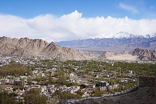
Leh is the joint capital and largest city of Ladakh, a union territory of India. Leh, located in the Leh district, was also the historical capital of the Kingdom of Ladakh, the seat of which was in the Leh Palace, the former residence of the royal family of Ladakh, built in the same style and about the same time as the Potala Palace in Tibet. Leh is at an altitude of 3,524 m (11,562 ft), and is connected via National Highway 1 to Srinagar in the southwest and to Manali in the south via the Leh-Manali Highway.
Leh district is a district in the union territory of Ladakh, India. With an area of 45,110 km2, it is the second largest district in the country smaller only to Kutch. It is bounded on the north by Gilgit-Baltistan's Kharmang and Ghanche districts and Xinjiang's Kashgar Prefecture and Hotan Prefecture linked via the historic Karakoram Pass. It has Aksai Chin and Tibet are to the east, Kargil district to the west, and Lahul and Spiti to the south. The district headquarters is in Leh. It lies between 32 to 36 degree north latitude and 75 to 80 degree east longitude.

Likir is a village and headquarter of eponymous Subdivision in the Leh district of Ladakh, India. It is located in the Likir tehsil, in the Ladakh region. Khalatse is a nearby trekking place.

Shey is a village in the Leh district of Ladakh, India. It is located in the Leh tehsil, 15 km from Leh towards Hemis.

Hemis, also spelled Hamis, is a village in the Leh district of Ladakh, India. It is located in the Kharu tehsil, 40 km southeast of Leh town on the Leh-Manali Highway and under-construction Bhanupli–Leh line.

Upshi is a village and road junction on the Leh-Manali Highway in the union territory of Ladakh in India. It is located 47 km (29 mi) to the southeast of Leh along the Indus river valley and Tanglang La on the Leh-Manali highway. Gya is also to the south.

Nimo or Nyemo is a village and the headquarters of an eponymous community development block in the Leh district of Ladakh, India. It is located in the Leh tehsil, 35 km from Leh.

Stakna is a village in the Leh district of Ladakh, India. It is located in the Leh tehsil, on the banks of the Indus River. The Stakna Monastery is located here.
Leh Deraz is a village in Milas Rural District, in the Central District of Lordegan County, Chaharmahal and Bakhtiari Province, Iran. At the 2006 census, its population was 485, in 87 families.
Leh Howzi is a village in Tayebi-ye Sarhadi-ye Gharbi Rural District, Charusa District, Kohgiluyeh County, Kohgiluyeh and Boyer-Ahmad Province, Iran. At the 2006 census, its population was 175, in 34 families.
Hemis-Shukpachan or Hemishok Pachan is a village in the Leh district of Ladakh, India. It is located in the Likir tehsil. Alternative transliterations of the village's name include Hemmis Shyk Pachan and Hemis Shukpachan.

Giramangu, also known as Gaira Mangue or Mangyu, is a village in the Leh district of Ladakh, India. It is located in the Likir tehsil. The Mangyu temple complex is located near this village.
Fotoksar or Photoksar is a village in the Leh district of Ladakh, India. It is located in the Khalsi tehsil.
Kungyam is a village in the Leh district in the Indian union territory of Ladakh. It is located in the rong block chumathang which primarily comes under Nyoma tehsil. Main language speak there is LOCAL LADAKHI
Umla is a village in the Leh district of Ladakh, India. It is located in the Likir tehsil.
Teri is a village in the Leh district of Ladakh, India. It is located in the Nyoma tehsil.
Ney is a village in the Leh district of Ladakh, India. It is located in the Leh tehsil.
Miru or Meroo is a village in the Leh district of Ladakh, India. It is located in the Kharu tehsil. The Leh–Manali Highway passes through Miru.
Suspol, also spelled Saspol, is a village and eponymous tehsil headquarter in the Leh district of Ladakh in India.
Skitmang is a village in the Leh district of the Indian union territory of Ladakh. It is located in the Leh tehsil.

