
Likir is a village and headquarter of eponymous Subdivision in the Leh district of Ladakh, India. It is located in the Likir tehsil, in the Ladakh region. Khalatse is a nearby trekking place.

Alchi is a village in the Leh district of Ladakh, India. It is located in the Likir tehsil, on the banks of the Indus River 70 km downstream from the capital Leh. Unlike the other gompas in Ladakh, Alchi is situated on lowland, not on a hilltop.
Tegar, also known as Kyagar, is a high-altitude village in the Leh district of Ladakh, India. It is located in the Nubra tehsil, in the Nubra Valley.

Hemis, also spelled Hamis, is a village in the Leh district of Ladakh, India. It is located in the Kharu tehsil, 40 km southeast of Leh town on the Leh-Manali Highway and under-construction Bhanupli–Leh line.

Chemrey is a village in the Leh district of Ladakh, India. It is located in the Kharu tehsil. The Chemrey Monastery is located in this village.

Nimo or Nyemo is a village and the headquarters of an eponymous community development block in the Leh district of Ladakh, India. It is located in the Leh tehsil, 35 km from Leh.

Thiksey is a village and the headquarters of its eponymous block in Leh district, Ladakh, India. It is located in the Leh tehsil. The Thikse Monastery is located here.

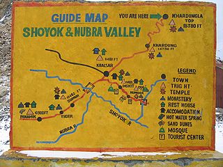
Diskit is a village and headquarter of the Nubra tehsil and the Nubra subdivision in the Leh district of Ladakh, India. The Diskit Monastery is located in this village.

Stakna is a village in the Leh district of Ladakh, India. It is located in the Leh tehsil, on the banks of the Indus River. The Stakna Monastery is located here.
Kharnak is a village in the Leh district of Ladakh, India. It is located in the Nyoma tehsil.

Giramangu, also known as Gaira Mangue or Mangyu, is a village in the Leh district of Ladakh, India. It is located in the Likir tehsil. The Mangyu temple complex is located near this village.

Lingshet is the headquarter of Singelalok block in the Leh district of Ladakh, India. It is located in the Khalsi tehsil, about a day's trek from the nearest road. The village can be accessed via a road through Singela from Lamayuru.

Lamayouro is a village in the Leh district of Ladakh, India. The Lamayuru Monastery is located nearby. It is located in the Khalsi tehsil. The region is also referred to as ‘Moon Land’, due to its terrain's resemblance to the surface of the Moon.
Fotoksar or Photoksar is a village in the Leh district of Ladakh, India. It is located in the Khalsi tehsil.

Temisgam is a village in the Leh district of Ladakh, India. It is located in the Khalsi tehsil. The Tingmosgang castle and monastery are located here.

Wanla is a village in the Leh district of Ladakh, India. It is located in the Khalsi tehsil, on the banks of the Yapola River. The Wanla Monastery is located in this village.

Phyang is a village in Leh district of Ladakh in India. It is in the Leh tehsil. The Phyang Monastery is in this village. This is one of the largest inhabited villages of Ladakh, comprising eight clusters: Phulungs, Phyang, Tsakma, Changmachan, Gaon, Thangnak, Chusgo and Mankhang. It is in a south-facing valley in the Ladakh Range of mountains. The village is about 15 km (9.3 mi) long and 1.5 km (0.93 mi) average width. There is an old dilapidated castle near the cluster of Phyang on a hilltop. Just below this castle, there is a single-room temple, Lobon, with paintings of Ladakh, but in the tourism industry, it is known as Guru Lhakhang. The Tokpo river is in the middle of the valley. The source of the river is small glaciers in upper Spangkul and Lungnak valley northwest of the village at an altitude of about 5,200 m (17,100 ft). The river joins the Indus River near Phey village at a lower altitude of 3,250 m (10,660 ft). The village has some tourist facilities, including a guesthouse and campsites. Hidden North guesthouse is just opposite the site of Guru Lhakhang at Tsakma cluster.

Hundar is a village in the Leh district of Ladakh, India, famous for sand dunes and Bactrian camels. It is located in the Nubra tehsil, on the banks of the Shyok River. The Hunder Monastery is located here.

Sakti is a village in the Leh district of Ladakh, India. It is located in the Leh tehsil. The Takthok Monastery is located here.
Suspol, also spelled Saspol, is a village and eponymous tehsil headquarter in the Leh district of Ladakh in India.

