Rangdum

Last updated

Rangdum
Village
Rangdum.jpg
Rangdum
India Ladakh location map UN view.svg
Red pog.svg
Rangdum
Location in Ladakh, India
India location map.svg
Red pog.svg
Rangdum
Rangdum (India)
Coordinates: 34°04′N76°21′E / 34.06°N 76.35°E / 34.06; 76.35 Coordinates: 34°04′N76°21′E / 34.06°N 76.35°E / 34.06; 76.35
CountryFlag of India.svg  India
Union territory Ladakh
District Kargil
Tehsil Taisuru [1]
Elevation
3,657 m (11,998 ft)
Languages
  Official Hindi, English
  Spoken Ladakhi, Purgi, Urdu
Time zone UTC+5:30 (IST)

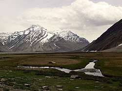
Rangdum is a village located in the Suru Valley in the union territory of Ladakh in Northern India. On one side are the colourful hills while on the other side are rocky mountains and glaciers, notably Drang-drung.

Rangdum is located midway between Kargil and Padum. It is about 100 kilometres (62 mi) from Kargil.

"Rangdum, with its gompa and the attendant village of Juliodok, is the last inhabited region in the Suru valley; it is also the destination of the nomadic herds people called Bakarwals, who trek up every year from the Himalayan foothills near Jammu, bringing their flocks of sheep and goats to grow fat on the rich summer growth of grass. From Rangdum the valley rises to 4400 metres and the Pensi-la, the gateway into Zanskar." [2]

Sheep of Rangdum village Rangdum village grazing fields.jpg
Sheep of Rangdum village

The country surrounding Rangdum Monastery is very bleak and crops sometimes cannot ripen in the brief summer. The locals depend on their flocks and supplies from lower down the Suru Valley or over the pass from Zanskar. [3]

The population of the Suru Valley as far as Parkachik are all Muslim. The spectacularly beautiful valley is, however, practically uninhabited past Parkachik other than a couple of tiny settlements. The small villages of Yuldo and Julidok, at the end of the valley, are entirely Buddhist. The people are socially and culturally part of neighbouring Zanskar and support the 18th-century Rangdum Monastery belonging to the Gelugpa sect of Tibetan Buddhism. [4] [5]

Rangdum has a tourist bungalow, three tea-houses and, around 2 km from the village, a summer-only camp offering accommodation for tourists in bedded tents. [6]

Footnotes

  1. "Villages in Kargil district". Kargil district website. Retrieved 1 May 2020.
  2. Rizvi (1996), p. 28.
  3. Rizvi (1996), p. 29.
  4. Rizvi (1996), pp. 29, 253.
  5. Schettler, Margaret & Rolf (1981), p. 150.
  6. Lonely Planet India guide, 12th edition

Related Research Articles

Zanskar

Zanskar, Zahar (locally) or Zangskar, is a tehsil of the Kargil district, which lies in the Indian union territory of Ladakh. The administrative centre is Padum. Zanskar, together with the neighbouring region of Ladakh, was briefly a part of the kingdom of Guge in Western Tibet. Zanskar lies 250 km south of Kargil town on NH301.

Kargil district District of Ladakh in India

Kargil district is a district in Ladakh, a region administered by India as a union territory. It spans the entire length of Ladakh in the north-south direction, with Jammu and Kashmir to the west, the Leh district to the east, the Pakistan-administered region of Gilgit–Baltistan to the north and Himachal Pradesh to the south. Encompassing two historical regions known as Purig and Zanskar, the district lies to the northwest of the Great Himalayan range and encompasses the majority of the Zanskar Range. Its population inhabits the river valleys of the Dras, Suru, Kartse, Wakha, and Zanskar rivers.

Padum Town in Ladakh, India

Padum is a town named after Padmasambhava. It is the only town and administrative centre in Zanskar. It was historically one of the two main capitals of the Zanskar Kingdom, the other being Zangla. It is 240 km away via the link road from Kargil town.

Alchi Village in Ladakh, India

Alchi is a village in the Leh district of Ladakh, India. It is located in the Likir tehsil, on the banks of Indus River 70 km downstream from the capital Leh. Unlike the other gompas in Ladakh, Alchi is situated on lowland, not on a hilltop.

History of Ladakh Aspect of history

Information about Ladakh before the birth of the kingdom during the 9th century is scarce. Ladakh can hardly be considered a separate political entity before the establishment of the kingdom about 950 CE, after the collapse of the early Tibetan Empire and the border regions became independent kingdoms under independent rulers, most of whom came from branches of the Tibetan royal family.

Geography of Ladakh Aspect of geography

The geographical region of Ladakh union territory is the highest altitude plateau region in India, incorporating parts of the Himalayan and Karakoram mountain ranges and the upper Indus River valley.

Suru River (Indus)

The Suru River, a tributary of Indus river that flows through the Kargil district of Ladakh. The Suru valley is coextensive with the Kargil tehsil (subdistrict), with the Kargil town occurring on its banks. The river flows north into the Skardu District of Baltistan in Pakistan, where it joins the Indus at Nurla.

Suru Valley

The Suru Valley is a valley in Kargil District in the Union Territory of Ladakh in India. It is drained by the Suru River, a powerful tributary of the Indus River. The valley's most significant town is Sankoo. Suru Valley is famous for its beauty. There are many picnic spots in Suru Valley such as Damsna, Parkachik, Sangra, Karpokhar, Khous, Thulus, Stakpa, Umba Namsuru etc. Karpokhar Holy Shrine(Syed Mir Hashim), Khous Holy Shrine & Sanku Holy Shrine are famous for prayer in Suru Valley. Horses, Yaks and other variety of animals can be found living in the valley. In winter Suru Valley experiences heavy snowfall and avalanches. The literacy rate of Suru Valley is very low as compared to other parts of Ladakh. Suru Valley is beautiful but still backward due to ignorance of govt & unavailability of infrastructure, power other things which supports for the development.

Pensi La

Pensi-la is a mountain pass in the Ladakh union territory of India, which is known as the Gateway to Zanskar. Pensi La is 4,400 m (14,436 ft) above sea level and connects the Suru Valley region to the Zanskar Valley region. The summit at this end of the Suru Valley, the only peak which can be seen, is 7,012 m (23,005 ft) high, while the mountain to the north is 6,873 m (22,549 ft). The pass is about 25 km from Rangdum Monastery.

Drang-Drung Glacier

The Drang-Drung Glacier is a mountain glacier near the Pensi La mountain pass at the Kargil - Zanaskar Road in the Kargil district of Ladakh in India.

Tourism in Ladakh

Tourism is one of an economic contributor to the union territory of Ladakh in Northern India. The union territory is part of the broader disputed Kashmir region and is sandwiched between the Karakoram mountain range to the north and the Himalayas to the south and is situated at the height of 11,400 ft. Ladakh is composed of the Leh and Kargil districts. The region contains prominent Buddhist sites and has an ecotourism industry. As of 2020, tourism industry in Ladakh was worth 600 crore (US$84 million).

Lamayuru Monastery

Lamayuru or Yuru Monastery is a Tibetan Buddhist monastery in Lamayouro, Leh district, Ladakh, India. It is situated on the Srinagar-Leh highway 15 kilometres (9.3 mi) east of the Fotu La at a height of 3,510 metres (11,520 ft).

Khalatse Village in Ladakh, India

Khaltse or Khalsi is the headquarter of eponymous Subdivision, block and tehsil in the Leh district of Ladakh, India. It is located 337 km from Srinagar on the old main road to Leh, where it crossed the Indus over an iron bridge. Much of its importance is because it is the place where the road from Kashmir debouches into the Indus Valley. Close by are the remains of an old fortified customs house.

Kursha Monastery

Karsha Monastery or Karsha Gompa is a Buddhist monastery in the Padum Valley of the Zanskar region of the union territory of Ladakh in northern India. The Doda River flows past the monastery from its source at the Drang Drung glacier of the Pensi La. It was founded by the translator, Phagspa Shesrab. The monastery, also known by the name "Karsha Chamspaling’, was founded by Phagspa Shesrab, under the Gelugpa Order or the Yellow Hat Order.

Rangdum Monastery

Rangdum Monastery is a Tibetan Buddhist monastery belonging to the Gelugpa sect, situated on top of a small but steep sugarloaf hill at an altitude of 4,031 m (13,225 ft) at the head of the Suru Valley, in Ladakh. It is next to the tiny village of Julidok, and about 25 km from the 4,400 m (14,436 ft) Pensi La (pass), which leads into Zanskar. The monastery was electrified using Solar Energy in June 2017 by Global Himalayan Expedition (GHE)

Sankar Monastery

Sankar Monastery, or Sankar Gompa is a Buddhist monastery within an easy half-hour walk from Leh in Ladakh, northern India. It is a daughter-establishment of Spituk Monastery and the residence of the Abbot of Spituk, the Venerable Kushok Bakula, who is the senior incarnate lama of Ladakh due to his ancient lineage and personal authority.

Mulbekh Monastery

Mulbekh Monastery or Mulbekh Gompa consist of two gompas, one Drukpa and one Gelugpa Buddhist monastery in Kargil, Ladakh, northern India. Names of the monasteries are Serdung Gompa and Rgaldan-se Gompa of Drukpa and Gelugpa sect respectively. Rgaldan-se Gompa was established by Tungba Lzawa also known as Agu Tungba. Recently the Rgaldan-se Gompa was reconstructed in 2016. It also consist a Lhakhang known as Nyima Lhakhang, it is the oldest section of the Mulbekh Monastery. It is believed to be built around 800 year ago by the students of great Tibetan scholar Lotsawa Rinchen Zangpo, it is clear with the style of painting.

Dzongkhul Monastery or Zongkhul Gompa is located in the Stod Valley of Zanskar in Ladakh, northern India. Like the Sani Monastery, it belongs to the Drukpa school of Tibetan Buddhism

Sani Monastery, Sa-ni-[tshog], is located next to the village of Sani where the Stod Valley broadens into the central plain of Zanskar in Ladakh, northern India. It is about 6 km to the northwest of the regional centre of Padum, a gentle two-hour walk. Like Dzongkhul Monastery, it belongs to the Drukpa Kargyu school of Tibetan Buddhism, and is the only one of this order in Zanskar which has nuns. It is thought to be the oldest religious site in the whole region of Ladakh and Zanskar.

Stongdey Monastery

Stongdey Monastery, often written Stongde, Stongday, Tonday or Thonde, is a flourishing Buddhist monastery in Zanskar, Ladakh, northern India, approximately 18 km north of Padum, on the road to Zangla.

References