Karzok

Last updated

Karzok
Korzok
Village
Karzok Tso Moriri.jpg
Ladakh relief map.svg
Red pog.svg
Karzok
Location in Ladakh, India
India relief location map.jpg
Red pog.svg
Karzok
Karzok (India)
Coordinates: 32°58′05″N78°15′50″E / 32.968125°N 78.2639885°E / 32.968125; 78.2639885 Coordinates: 32°58′05″N78°15′50″E / 32.968125°N 78.2639885°E / 32.968125; 78.2639885
Country India
Union Territory Ladakh
District Leh
Tehsil Nyoma [1]
Elevation
4,595 m (15,075 ft)
Population
 (2011)
  Total1,291
Time zone UTC+5:30 (IST)
2011 census code899
Karzok

Karzok or Korzok is a village in the Leh district of Ladakh, India. [2] It is located close to Nyoma, in the Rupshu region and block, on the shores of the Tso Moriri lake. It is among the highest towns in the world and the highest settlement in India. [3] Various sources give slightly different measurements of the altitude from 14,995 ft (4,570 m) to 15,075 ft (4,595 m) above sea level. [4] The Drukpa Buddhist Korzok Monastery is located here.

Contents

History

Karzok was on the Central Asian trade route until 1947 and was the headquarters of the Rupshu Valley. One of the kings, Rupshu Goba, who lived there with his family, built nine permanent houses there. [5]

The village has several houses, and the nomadic population who establish their tents (made of yak hair or skin) in summer, add to the agricultural operations in the region. The tents are provided with vents at the top to let out the smoke. Pashmina is the valuable product that the Changmas trade along with the salt that they extract from large salt fields in the area, such as the springs at Puga. They barter these two products for food grains and other necessities. In recent years, building activity is on the rise with the nomadic tribes changing their lifestyle. [6]

Demographics

Karzok village Karzok.jpg
Karzok village

According to the 2011 census of India, Karzok has 253 households. The effective literacy rate (i.e. the literacy rate of population excluding children aged 6 and below) is 46.64%. [7]

Demographics (2011 Census) [7]
TotalMaleFemale
Population1291673618
Children aged below 6 years18910287
Scheduled caste 422
Scheduled tribe 931485446
Literates514292222
Workers (all)813450363
Main workers (total)31522590
Main workers: Cultivators25719265
Main workers: Agricultural labourers321
Main workers: Household industry workers606
Main workers: Other493118
Marginal workers (total)498225273
Marginal workers: Cultivators224117107
Marginal workers: Agricultural labourers734
Marginal workers: Household industry workers12619107
Marginal workers: Others1418655
Non-workers478223255
Welcome sign, Karzok Karzok welcome sign.jpg
Welcome sign, Karzok

Climate

Karzok has a subarctic climate (Köppen classification Dfc) bordering on a tundra climate (ET). Summers are cool with chilly nights, and winters are long and cold with lows below zero.

Climate data for Karzok
MonthJanFebMarAprMayJunJulAugSepOctNovDecYear
Average high °C (°F)−7.2
(19.0)
−5.4
(22.3)
−1.2
(29.8)
4.3
(39.7)
9.2
(48.6)
14.0
(57.2)
16.9
(62.4)
16.2
(61.2)
12.9
(55.2)
6.5
(43.7)
1.2
(34.2)
−3.5
(25.7)
5.3
(41.6)
Daily mean °C (°F)−13.1
(8.4)
−11.2
(11.8)
−6.8
(19.8)
−1.5
(29.3)
2.9
(37.2)
7.4
(45.3)
10.7
(51.3)
10.2
(50.4)
6.4
(43.5)
−0.2
(31.6)
−5.6
(21.9)
−10.0
(14.0)
−0.9
(30.4)
Average low °C (°F)−18.9
(−2.0)
−16.9
(1.6)
−12.4
(9.7)
−7.2
(19.0)
−3.3
(26.1)
0.9
(33.6)
4.5
(40.1)
4.2
(39.6)
0.0
(32.0)
−6.8
(19.8)
−12.4
(9.7)
−16.5
(2.3)
−7.1
(19.3)
Average precipitation mm (inches)22
(0.9)
21
(0.8)
24
(0.9)
19
(0.7)
19
(0.7)
9
(0.4)
28
(1.1)
34
(1.3)
23
(0.9)
12
(0.5)
7
(0.3)
12
(0.5)
230
(9)
Source: climate-data.com

Related Research Articles

Geography of Ladakh Aspect of geography

The geographical region of Ladakh union territory is the highest altitude plateau region in India, incorporating parts of the Himalayan and Karakoram mountain ranges and the upper Indus River and valley.

Changtang North-West Tibet geographic highland

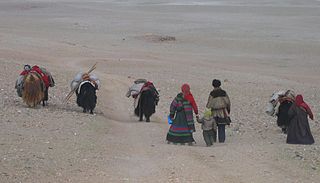
The Changtang is a part of the high altitude Tibetan Plateau in western and northern Tibet extending into the southern edges of Xinjiang as well as southeastern Ladakh, India, with vast highlands and giant lakes. From eastern Ladakh, the Changtang stretches approximately 1,600 kilometres (990 mi) east into Tibet as far as modern Qinghai. The Changtang is home to the Changpa, a nomadic Tibetan people. The two largest settlements within the Tibetan Changtang are Rutog Town the seat of Rutog County and Domar Township the seat of Shuanghu County.

Tourism in Ladakh

Tourism is one of an economic contributor to the union territory of Ladakh in Northern India. The union territory is sandwiched between the Karakoram mountain range to the north and the Himalayas to the south and is situated at the height of 11,400 ft. Ladakh is composed of the Leh and Kargil districts. The region contains prominent Buddhist sites and has an ecotourism industry.

Tso Moriri Lake in Ladakh, India

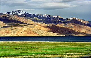
Tso Moriri or Lake Moriri or "Mountain Lake", is a lake in the Changthang Plateau of Ladakh in India. The lake and surrounding area are protected as the Tso Moriri Wetland Conservation Reserve.

Tegar Village in Ladakh, India

Tegar, also known as Kyagar, is a high-altitude village in the Leh district of Ladakh, India. It is located in the Nubra tehsil, in the Nubra Valley.

Rupshu is a high altitude plateau and valley and an eponymous community development block in southeast Ladakh.

Upshi Village in Ladakh, India

Upshi is a village and road junction on the Leh-Manali Highway in the union territory of Ladakh in India. It is located 47 km (29 mi) to the southeast of Leh along the Indus river valley and Tanglang La on the Leh-Manali highway. Gya is also to the south.

Nimo, Ladakh Village in Ladakh, India

Nimo or Nyemo is a village and the headquarters of an eponymous community development block in the Leh district of Ladakh, India. It is located in the Leh tehsil, 35 km from Leh.

Korzok Monastery

Korzok, is a Tibetan Buddhist monastery belonging to the Drukpa Lineage. It is located in the Korzok village, on the northwestern bank of Tso Moriri (lake) in Leh District, Ladakh, India. The gompa (monastery), at 4,560 metres (14,960 ft), houses a Shakyamuni Buddha and other statues. It is home to about 70 monks.

Nyoma Village in Ladakh, India

Nyoma is a principal village of southern Ladakh in India, the headquarters of an eponymous subdivision, tehsil and community development block in the Leh district. It is located on the bank of Indus River, after its 90-degree bend near Dungti and before the valley narrows to a gorge near Mahe. A Buddhist monastery ("gompa") is located on the hill at the back of the village.

Tso Kar Ramsar wetland in India

The Tso Kar or Tsho kar is a fluctuating salt lake known for its size and depth situated in the Rupshu Plateau and valley in the southern part of Ladakh in India. It is also recognised as India's 42nd Ramsar site.

Chumathang Village in Ladakh, India

Chumathang is a village in Leh District, Ladakh in northern India on the banks of the Indus river.

Kargyam Village cluster in Ladakh, India

Kargyam is a village in Leh district of the Indian union territory of Ladakh. It is located in the Durbuk tehsil (subdistrict), in the Long Parma valley between Tangtse and Chushul. Kargyam is famous for its wetlands and Blackneck crane and nomadic lifestyle.

Man Pangong is a village in the Leh district of the Indian union territory of Ladakh. It is located in the Durbuk tehsil, near the Pangong Tso lake.

Durbuk or Darbuk, is a village and the headquarters of the eponymous subdivision and block in the Leh district of Ladakh, India. It is located in the Durbuk tehsil, and falls between Chang La mountain pass and Tangste village on the way to Pangong Tso Lake.

Gia, Leh Village in Ladakh, India

Gia or Gya is a village in the Leh district of Ladakh in India. It is located in the Kharu tehsil, off the Leh–Manali Highway, close to Tso Kar.

Teri is a village in the Leh district of Ladakh, India. It is located in the Nyoma tehsil.

Skitmang is a village in the Leh district of the Indian union territory of Ladakh. It is located in the Leh tehsil.

Shara is a village in the Leh district of Ladakh, India. It is located in the Kharu tehsil.

Kyagar Tso or Kyagar Lake is a small brackish lake surrounded by mountains situated in the Ladakh region of the northern Indian Union Territory of Ladakh in India. From afar, it can be spotted by its turquoise colour.

References

  1. "Villages | District Leh, Union Territory of Ladakh | India".
  2. "Blockwise Village Amenity Directory" (PDF). Ladakh Autonomous Hill Development Council. Retrieved 23 July 2015.
  3. Korzok | https://www.dangerousroads.org/asia/india/5683-korzok.html
  4. List of highest cities in the world
  5. Jina, Prem Singh (1995). High pasturelands of Ladakh Himalaya. Korzok. Indus Publishing. p. 49. ISBN   978-81-7387-026-2 . Retrieved 22 November 2009.
  6. "Tso Moriri - Tea with Changpas". The Statesman. 16 June 2004. Retrieved 23 November 2009.
  7. 1 2 "Leh district census". 2011 Census of India . Directorate of Census Operations. Retrieved 23 July 2015.