
Mesquite Bosque is a vegetative association within the Southwestern United States, under the Kuchler scheme of plant association categories.
Mesquite Bosque is a vegetative association within the Southwestern United States, under the Kuchler scheme of plant association categories.
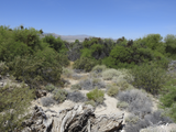
The Mesquite Bosque association occurs in the Sonoran Desert, with mesquite (Prosopis spp.) dominating. In some cases, this plant association is along xeric portions of desert floodplains, bajadas, and arroyos. [1]
The mesquite (Prosopis) species include:
Other species include:


Mesquite is a common name for several plants in the genus Prosopis, which contains over 40 species of small leguminous trees. They are native to dry areas in the Americas. They have extremely long roots to seek water from very far under ground. As a legume, mesquites are one of the few sources of fixed nitrogen in the desert habitat. The trees bloom from spring to summer. They often produce fruits known as "pods". Prosopis spp. are able to grow up to 8 metres (26 ft) tall, depending on site and climate. They are deciduous and depending on location and rainfall have either deep or shallow roots. Prosopis is considered long-lived because of the low mortality rate after the dicotyledonous stage and juveniles are also able to survive in conditions with low light and drought. The Cahuilla indigenous people of western North America were known to eat the seeds of mesquite.

The Sonoran Desert is a desert in North America and ecoregion that covers the northwestern Mexican states of Sonora, Baja California, and Baja California Sur, as well as part of the southwestern United States. It is the hottest desert in both Mexico and the United States. It has an area of 260,000 square kilometers (100,000 sq mi).

The Chihuahuan Desert is a desert ecoregion designation covering parts of northern Mexico and the southwestern United States. It occupies much of far West Texas, the middle to lower Rio Grande Valley and the lower Pecos Valley in New Mexico, and a portion of southeastern Arizona, as well as the central and northern portions of the Mexican Plateau. It is bordered on the west by the Sonoran Desert, the Colorado Plateau, and the extensive Sierra Madre Occidental range, along with northwestern lowlands of the Sierra Madre Oriental range. Its largest, continual expanse is located in Mexico, covering a large portion of the state of Chihuahua, along with portions of Coahuila, north-eastern Durango, the extreme northern part of Zacatecas, and small western portions of Nuevo León. With an area of about 501,896 km2 (193,783 sq mi), it is the largest desert in North America. The desert is fairly young, existing for only 8000 years.

Anza-Borrego Desert State Park is a California State Park located within the Colorado Desert of southern California, United States. The park takes its name from 18th century Spanish explorer Juan Bautista de Anza and borrego, a Spanish word for sheep. With 585,930 acres (237,120 ha) that includes one-fifth of San Diego County, it is the largest state park in California.

Washingtonia is a genus of palms, native to the southwestern United States and northwest Mexico. Both Washingtonia species are commonly cultivated across the Southern United States, the Middle East, southern Europe, and North Africa, where they have greatly hybridized.

The Baja California Desert is a desert ecoregion of Mexico's Baja California peninsula. This ecoregion occupies the western portion of the Baja California peninsula, and occupies most of the Mexican states of Baja California Sur and Baja California. It covers 77,700 square kilometers. The climate is dry, but its proximity of the Pacific Ocean provides humidity and moderates the temperature. The flora mostly consists of xeric shrubs and over 500 species of recorded vascular plants.

Prosopis juliflora is a shrub or small tree in the family Fabaceae, a kind of mesquite. It is native to Mexico, South America and the Caribbean. It has become established as an invasive weed in Africa, Asia, Australia and elsewhere. It is a contributing factor to continuing transmission of malaria, especially during dry periods when sugar sources from native plants are largely unavailable to mosquitoes.
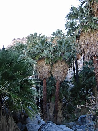
Washingtonia filifera, the desert fan palm, California fan palm, or California palm, is a flowering plant in the palm family Arecaceae, native to the far southwestern United States and Baja California, Mexico. Growing to 15–20 m (49–66 ft) tall by 3–6 m (10–20 ft) broad, it is an evergreen monocot with a tree-like growth habit. It has a sturdy, columnar trunk and waxy, fan-shaped (palmate) leaves.

Washingtonia robusta, known by common name as the Mexican fan palm, Mexican washingtonia, or skyduster is a palm tree native to the Baja California peninsula and a small part of Sonora in northwestern Mexico. Despite its limited native distribution, W. robusta one of the most widely cultivated subtropical palms in the world. It is naturalized in Florida, California, Hawaii, Texas, parts of the Canary Islands, France, Italy, Israel, Jordan, Lebanon, Qatar, Spain, Réunion, and Morocco.
The Sierra Juárez and San Pedro Mártir pine–oak forests is a Nearctic temperate coniferous forests ecoregion that covers the higher elevations of the Sierra Juárez and Sierra San Pedro Mártir ranges of the Peninsular Ranges, of the northern Baja California Peninsula of Mexico. The pine–oak forests extend throughout the central portion of the Mexican state of Baja California and terminate near the border with the U.S. state of California.

The Turtle Mountains, are located in northeastern San Bernardino County, in the southeastern part of California. The colorful Turtle Mountains vary from deep reds, browns, tans and grays, to black. The area has numerous springs and seeps. The Turtle Mountains are also a National Natural Landmark, with two mountain sections of entirely different composition.
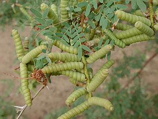
Prosopis pubescens, commonly known as screwbean mesquite, is a species of flowering shrub or small tree in the pea family, Fabaceae, that is native to the southwestern United States and northern Mexico.

The Santa Rosa and San Jacinto Mountains National Monument is a National Monument in southern California. It includes portions of the Santa Rosa and San Jacinto mountain ranges, the northernmost ones of the Peninsular Ranges system. The national monument covers portions of Riverside County, west of the Coachella Valley, approximately 100 miles (160 km) southeast of downtown Los Angeles.

Comal Springs are the largest concentration of naturally occurring freshwater springs in Texas. They are located in the city of New Braunfels and are the result of water percolating through the Edwards Aquifer formation.

The Texas Coastal Bend, or just the Coastal Bend, is a geographical region in the US state of Texas. The name refers to the area being a curve along the Texas Gulf Coast of the Gulf of Mexico. The largest city of the Coastal Bend is Corpus Christi. It includes the Nueces Estuary and the Mission–Aransas Estuary, as well as part of Laguna Madre. The coastline is paralleled by several of the Texas barrier islands, including North Padre Island, Mustang Island, and San José Island.

Prosopis glandulosa, commonly known as honey mesquite, is a species of small to medium-sized, thorny shrub or tree in the legume family (Fabaceae).

Prosopis velutina, commonly known as velvet mesquite, is a small to medium-sized tree. It is a legume adapted to a dry, desert climate. Though considered to be a noxious weed in states outside its natural range, it plays a vital role in the ecology of the Sonoran Desert.

The white-throated woodrat is a species of rodent in the family Cricetidae. It is found from central Mexico north to Utah and Colorado in the United States. It is primarily a western species in the United States, extending from central Texas west to southeastern California. Populations east of the Rio Grande in New Mexico and Trans-Pecos Texas, previously considered to be variants of the white-throated woodrat, have since 1988 been assigned to the white-toothed woodrat.
The Mopah Range is a desert mountain range, in the Lower Colorado River Valley region, in southeastern San Bernardino County, California.

Desert riparian is a North American desert vegetation type occurring in the bottoms of valleys, canyons, and other watercourses that have water at or near the surface most of the year. The visual character is of large, lush, perennial green trees surrounded by dry desert vegetation and soil coloration. The area may be in a patch surrounding a spring such as an oasis, or in a strand following the course of water flow, such as a bosque. The soil in this biome is typically moist and ranges from rocky and sandy to silty alluvium. This biome has seasonal variation, with hot, dry summers and cool, moist winters. Precipitation mostly occurs during the winter, and ranges from 8 to 25 cm each year. It is contrasted with the desert dry wash vegetation type, in which water at or near the surface is lacking most of the year, such as arroyos.