
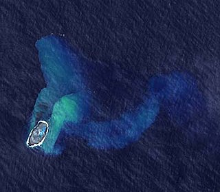
Metis Shoal, also known as Lateiki Island, is a volcanic island at the top of a submarine volcano in Tonga, located between the islands of Kao and Late. The current island formed in October 2019, when a smaller island disappeared after 24 years.
Metis Shoal, also known as Lateiki Island, is a volcanic island at the top of a submarine volcano in Tonga, located between the islands of Kao and Late. The current island formed in October 2019, when a smaller island disappeared after 24 years.
The shoal was named by the captain of HMS Metis in 1875, who found a small volcanic island protruding from the ocean. The island was reported as being 200m long and 37m high by HMS Sappho in 1878, and as 480m high in 1890, but had eroded away completely by 1898, leaving a shoal covered by 4m of water. [1] Eruptions and short-lived islands have been reported as far back as 1781, according to the Global Volcanism Program. [2] In December 1967 an eruption produced another short-lived island, [3] which disappeared by the end of 1968. [1] An eruption in 1979 discharged large amounts of pumice, and formed an island 16km in diameter. [4] The new island was named "Lateiki" ("lies besides Late") [1] and claimed by Tonga in a flag-raising ceremony, [5] but soon eroded beneath the sea surface. [2]

During an eruption in 1995, a new island (latitude: 19.18°S, longitude: 174.8°W) appeared which had a diameter of 280 metre and a height of 43 metre following the growth of a lava dome above the surface. On 7 December 2006 the Royal New Zealand Air Force (RNZAF) flew over Metis Shoal and Home Reef at the request of volcanologists from the Institute of Geological & Nuclear Sciences (IGNS) to take photos of Metis Shoal.
Another eruption commenced in October 2019. [6] This eruption was first reported by Tongan vessel MV Ngutulei on the morning of 14 October 2019 and continued for more than two weeks. Photos were later taken by aircraft from Real Tonga and Air New Zealand, which showed that Metis Shoal had completely sunk.
The Tonga Geological Service announced on 6 November 2019 that the eruption in October produced a new and bigger island, about 120 metres west of the island which disappeared. The new island was estimated to be 100 metres wide and 400 metres long, which is three times bigger than the previous one. [7] [8] [9]

Located in Oceania, Tonga is a small archipelago in the South Pacific Ocean, directly south of Samoa and about two-thirds of the way from Hawaii to New Zealand. It has 169 islands, 36 of them inhabited, which are in three main groups – Vavaʻu, Haʻapai, and Tongatapu – and cover an 800-kilometre (500-mile)-long north–south line. The total size is just 747 km2 (288 sq mi). Due to the spread out islands it has the 40th largest Exclusive Economic Zone of 659,558 km2 (254,657 sq mi).

Whakaari / White Island, also known as White Island or Whakaari, is an active andesite stratovolcano situated 48 km (30 mi) from the east coast of the North Island of New Zealand, in the Bay of Plenty. The island covers an area of approximately 325 ha, which is just the peak of a much larger submarine volcano.
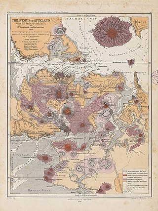
The Auckland volcanic field is an area of monogenetic volcanoes covered by much of the metropolitan area of Auckland, New Zealand's largest city, located in the North Island. The approximately 53 volcanoes in the field have produced a diverse array of maars, tuff rings, scoria cones, and lava flows. With the exception of Rangitoto, no volcano has erupted more than once, but the other eruptions lasted for various periods ranging from a few weeks to several years. Rangitoto erupted several times and recently twice; in an eruption that occurred about 600 years ago, followed by a second eruption approximately 50 years later. The field is fuelled entirely by basaltic magma, unlike the explosive subduction-driven volcanism in the central North Island, such as at Mount Ruapehu and Lake Taupō. The field is currently dormant, but could become active again.

Ferdinandea Island is a submarine volcano in the Mediterranean Sea near the island of Sicily that has, on more than one occasion, risen above the surface of the Mediterranean via volcanic action and soon thereafter been washed away. Since 300 BC this cycle of events has occurred four times.

Niuafoʻou is the northernmost island in the kingdom of Tonga. One of the Niua Islands, it is located in the southern Pacific Ocean between Fiji and Samoa, 574 km (357 mi) north of Tongatapu island group and 337 km (209 mi) northwest of Vavaʻu. It is a volcanic rim island with an area of 15 km2 (5.8 sq mi) and a population of 431. The volcano is active and has erupted regularly since 1814, with its last major eruption in 1985.

Tofua is a volcanic island in Tonga. Located in the Haʻapai island group, it is a steep-sided composite cone with a summit caldera. It is part of the highly active Kermadec-Tonga subduction zone and its associated volcanic arc, which extends from New Zealand north-northeast to Fiji, and is formed by the subduction of the Pacific Plate under the Indo-Australian Plate. It lies about 100 km (62 mi) above a very active seismic zone. It is connected to the nearby island of Kao by a submarine ridge.

Haʻapai is a group of islands, islets, reefs, and shoals in the central part of Tonga. It has a combined land area of 109.30 square kilometres (42.20 sq mi). The Tongatapu island group lies to its south, and the Vavaʻu group lies to its north. Seventeen of the Haʻapai islands are inhabited. Their combined population is 5,419. The highest point in the Ha‘apai group, and in all of Tonga, is on Kao, which rises almost 1,050 metres (3,440 ft) above sea level.

Fonualei is an uninhabited volcanic island in the kingdom of Tonga. It 70 km northwest of Vavaʻu and is part of the highly active Kermadec-Tonga subduction zone and its associated volcanic arc, which extends from New Zealand north-northeast to Fiji, and is formed by the subduction of the Pacific Plate under the Indo-Australian Plate. The closest island to Fonualei is Tokū 19.7 km to the southeast.
Home Reef is a volcanic island atop a submarine volcano in Tonga. It is located southwest of Vava'u, between the islands of Kao and Late along the Tofua volcanic arc. The island is ephemeral, and has been repeatedly built and eroded by successive eruptions in 1852, 1857, 1984, 2006, and 2022.
Curacoa is a submarine volcano located south of the Curacoa Reef in northern Tonga. The reef is 24fm North of Tafahi in the Niua Islands. Eruptions were observed in 1973 and 1979 from two separate vents. The 1973 eruption produced a large raft of dacitic pumice, and had a volcanic explosivity index (VEI) of 3.

The volcanism of New Zealand has been responsible for many of the country's geographical features, especially in the North Island and the country's outlying islands.

Fonuafo‘ou, formerly known as Falcon Island, is a submarine volcano in the western part of the Ha'apai group in Tonga. The volcano has created an island several times throughout history.

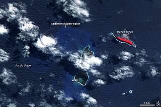
Hunga Tonga–Hunga Haʻapai is a submarine volcano in the South Pacific located about 30 km (19 mi) south of the submarine volcano of Fonuafoʻou and 65 km (40 mi) north of Tongatapu, Tonga's main island. It is part of the highly active Kermadec-Tonga subduction zone and its associated volcanic arc, which extends from New Zealand north-northeast to Fiji, and is formed by the subduction of the Pacific Plate under the Indo-Australian Plate. It lies about 100 km (62 mi) above a very active seismic zone.
The 2009 Tonga undersea volcanic eruption began on 16 March 2009, near the island of Hunga Tonga, approximately 62 kilometres (39 mi) from the Tongan capital of Nukuʻalofa. The volcano is in a highly active volcanic region that represents a portion of the Pacific Ring of Fire. It is estimated that there are up to 36 undersea volcanoes clustered together in the area.
Events in the year 2019 in Tonga.
On the morning of March 13, 1888, an explosion took place on Ritter Island, a small volcanic island in the Bismarck and Solomon Seas, between New Britain and Umboi Island. The explosion resulted in the almost complete loss of the island and generated a tsunami with runups of up to 15 meters (49 ft) that caused damage more than 700 kilometers (430 mi) away and killed anywhere between 500 and 3,000 on neighbouring islands, including scientists and explorers. This event is the largest volcanic island sector collapse in recent history.
In December 2021, an eruption began on Hunga Tonga–Hunga Haʻapai, a submarine volcano in the Tongan archipelago in the southern Pacific Ocean. The eruption reached a very large and powerful climax nearly four weeks later, on 15 January 2022. Hunga Tonga–Hunga Haʻapai is 65 kilometres (40 mi) north of Tongatapu, the country's main island, and is part of the highly active Tonga–Kermadec Islands volcanic arc, a subduction zone extending from New Zealand to Fiji. In the Volcanic Explosivity Index scale, the eruption was rated at least a VEI-5. Described by scientists as a "magma hammer", the volcano at its height produced a series of four underwater thrusts, displaced 10 cubic kilometres (2.4 cu mi) of rock, ash and sediment, and generated the largest atmospheric explosion recorded by modern instrumentation.
Mango is a small island in Tonga, 9 kilometres south-east of the larger island of Nomuka, and part of the Nomuka or ʻOtu Muʻomuʻa group of islands, which are the southern part of the Haʻapai group. Mango had a population of 62 in the 2021 census.
| Authority control: Geographic |
|---|