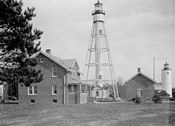
The current tower | |
 | |
| Location | Michigan Island, Wisconsin |
|---|---|
| Coordinates | 46°52′17.154″N90°29′49.545″W / 46.87143167°N 90.49709583°W [1] |
| Tower | |
| Constructed | 1857 |
| Foundation | Concrete |
| Construction | Steel |
| Automated | 1943 |
| Height | 118 feet (36 m) |
| Shape | White, Skeletal with a central column |
| Heritage | National Register of Historic Places contributing property |
| Light | |
| First lit | 1869 |
| Focal height | 170 feet (52 m) |
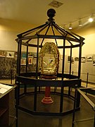
| Lens | Third and half order Fresnel lens (original), 12-inch (300 mm)Tideland Signal ML-300 Acrylic Optic (current) |
| Range | 11 nautical miles (20 km; 13 mi) [1] |
| Characteristic | White, Flashing, 6 sec [1] |
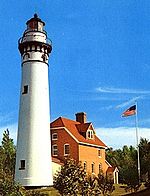
Michigan Island Light | |
| Area | 33.8 acres (13.7 ha) |
| Built | 1857 |
| Built by | U.S. Lighthouse Service |
| Part of | Apostle Islands Lighthouses (ID77000145 [2] ) |
| Designated CP | March 8, 1977 |
The Michigan Island Lighthouse is a lighthouse operated by the National Park Service and located on Michigan Island on western Lake Superior in the Apostle Islands National Lakeshore.