Related Research Articles

Southampton County is a county located on the southern border of the Commonwealth of Virginia. North Carolina is to the south. As of the 2010 census, the population was 18,570. Its county seat is Courtland.
Greensville County is a county located in the Commonwealth of Virginia. As of the 2010 census, the population was 12,243. Its county seat is Emporia.

Emporia is an independent city in the Commonwealth of Virginia, surrounded by Greensville County, in the United States. It and a predecessor town have been the county seat of Greensville County since 1791. As of the 2010 census, the population was 5,927, making it the second-least populous city in Virginia. The Bureau of Economic Analysis combines the city of Emporia with surrounding Greensville county for statistical purposes.

Hertford County is a county located in the U.S. state of North Carolina. As of the 2010 census, the population was 24,669. Its county seat is Winton. It is classified within the region known in the 21st century as the Inner Banks.

Murfreesboro is a town in Hertford County, North Carolina, United States. The population was 2,835 at the 2010 census. The town is home to Chowan University.
The Meherrin Nation is one of seven state-recognized nations of Native Americans in North Carolina. They reside in rural northeastern North Carolina, near the river of the same name on the Virginia-North Carolina border. Historically the Iroquoian-speaking tribe had lived in the Piedmont of Virginia but moved south in the early 18th century under pressure of English colonists' encroachment on their territory.

The Chowan River (cho-WAHHN) is a blackwater river formed with the merging of Virginia's Blackwater and Nottoway rivers near the stateline between Virginia and North Carolina. According to the USGS a variant name is Choan River.
The Meherrin River is a 143.37 mi (230.73 km) long 6th order tributary to the Chowan River that joins in Hertford County, North Carolina.

State Route 35 is a primary state highway in the U.S. state of Virginia. The state highway runs 48.71 miles (78.39 km) from the North Carolina state line near Boykins, where the highway continues as North Carolina Highway 35, north to SR 605 and SR 622 in Templeton. SR 35 is the main north–south highway of Southampton County; the highway also connects U.S. Route 58 in Courtland with Interstate 95 (I-95) and US 301 at Templeton south of Petersburg.
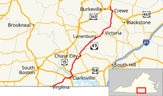
State Route 49 is a primary state highway in the U.S. state of Virginia. The state highway runs 69.01 miles (111.06 km) from the North Carolina state line in Virgilina, Virginia in Halifax County, where the highway continues south as North Carolina Highway 49, north to U.S. Route 360 near Burkeville in Nottoway County. SR 49 passes through Southside Virginia, connecting Virgilina and Burkeville with Clarksville and Chase City in Mecklenburg County, Victoria in Lunenburg County, and Crewe in Nottoway County. Via US 360, the state highway connects Richmond with the John H. Kerr Reservoir.
The Occaneechi are Native Americans who lived in the 17th century primarily on the large, 4-mile (6.4 km) long Occoneechee Island and east of the confluence of the Dan and Roanoke rivers, near current-day Clarksville, Virginia. They were Siouan-speaking, and thus related to the Saponi, Tutelo, Eno and other Southeastern Siouan-language peoples living in the Piedmont region of present-day North Carolina and Virginia.

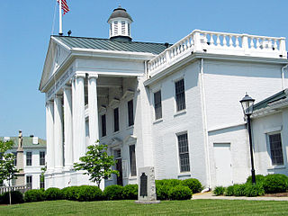
Lunenburg is a census-designated place (CDP) in and the county seat of Lunenburg County, Virginia, United States. The population was 165 at the 2010 census. The community is also known as Lunenburg Courthouse or Lunenburg Court House.

George Coke Dromgoole was a nineteenth-century politician and lawyer from Virginia. He was the uncle of Alexander Dromgoole Sims and the son of Irish-born pioneer Methodist circuit rider Edward Dromgoole.

Meherrin is a small unincorporated community in Lunenburg and Prince Edward counties in the U.S. state of Virginia. It is approximately 18.6 miles by road south of Farmville.

The Nottoway are a Native American tribe in Virginia. Historically, the Nottoway spoke an Iroquoian language, Nottoway, and were related to other Iroquoian speakers.
Fountains Creek, also known as Fontaine Creek, is a tributary of the Meherrin River in the U.S. state of Virginia. Formed by the confluence of Beddingfield Creek and Rattlesnake Creek in southwestern Greensville County, it flows into the Meherrin River near the Virginia–North Carolina border, about 1.2 miles (2 km) north of Margarettsville, North Carolina.
The North Meherrin River is a river in the United States state of Virginia.
The South Meherrin River is a river in the United States state of Virginia.
References
- USGS Hydrologic Unit Map - State of Virginia (1974)
- Salmon, Emily J.; Edward D. C. Campbell, Jr., eds. (1994). The Hornbook of Virginia History (4th ed.). Richmond, VA: Virginia Office of Graphic Communications. ISBN 0-88490-177-7.