Midland Railway Clowne Branch

Last updated

The Clowne Branch is a disused railway line in north eastern Derbyshire, England. Which runs from Creswell to Staveley. Historically it ran to Chesterfield. It is now in use as a greenway.

Contents

Construction

The Mansfield Lines Act of 8 July 1865 authorised the construction of the branch, [1] along with others in the area which was undergoing rapid industrialisation, especially in the coal and iron industries.

The 5.75 miles (9.25 km) line was built by the Midland Railway from Seymour Junction [2] [3] [4] on their Doe Lea Valley line to Creswell Junction, [5] [6] immediately north of Elmton and Creswell on their Nottingham to Worksop line, now known as the Robin Hood Line. It was physically completed by January 1872, but not opened throughout until 1 June 1875 and then only for freight, the sole traffic up to that point being coal from Barlborough Colliery.

The branch served three collieries – Oxcroft, Barlborough and Southgate [7] [8] – and one station, initially called Clown ("e" was only added to the village and its railway features in the 20th Century) but was later renamed twice, becoming Clowne and Barlborough in 1951. The primary purpose of the line was to give access from the east to the booming coal and iron industries in the Staveley area.

The line was steeply graded from both ends to its summit at Clowne. It had no tunnels, but required three substantial cuttings and a 70 feet (21 m) embankment. Further significant work occurred in the late 1960s when it was bridged by the new M1 Motorway. [9]

Between 1896 and 1900 the LD&ECR built their Beighton Branch which both adjoined and crossed the Clowne Branch in Clowne. Relations between the Midland Railway and the new company were good. A connection was laid between the two lines in Clowne, running north west to south east, some distance east of both companies' stations. It was only ever used for freight and closed in 1937. [10]

The line has the Engineer's Line Reference (ELR) BAC3. [11] Codes beginning "BAC3" appear on structures such as bridges which remain Network Rail's responsibility, even though tracks have been lifted.

Passenger services

Passenger services commenced on 1 November 1888, thirteen years after opening and sixteen years after physical completion. Three trains a day plied between Mansfield and Chesterfield, calling at all stations via Elmton and Creswell, Clown, Netherthorpe, Staveley and Whittington. A common thread between these stations is that every one of them was subsequently renamed at least once or, in the case of Whittington, relocated. The time taken for this sinuous 21 miles (34 km) journey was about an hour. [12]

By 1922 five trains a day, Monday to Saturday, plied the route, [13] but this was the high-water mark. By 1952 only one train each way, Monday to Friday, served Clowne and Barlborough, timed to suit schools. That was withdrawn on 5 July 1954. [14] The station's goods facilities closed in July 1960, leaving its sole purpose excursions, such as for football matches, and Summer Saturday holiday traffic, notably from Radford to Blackpool North. That called for the last time on 18 August 1962. [15]

The last steam train to use the line was a non-stop enthusiasts' special on 16 October 1965. [16] [17] This train also traversed the Doe Lea Branch.

Freight

Freight was always the line's primary purpose. Barlborough Colliery ceased production in 1921 and Southgate followed in 1929.

Oxcroft Colliery, at Stanfree, survived until 27 February 1976. [18] After it closed its facilities for loading coal onto trains were retained and developed as the "Oxcroft Disposal Point" [19] for opencasted coal. The site had something of a Red Letter Day on 9 May 1992 when Class 58 locomotive 58 044 was ceremonially named "Oxcroft Opencast". [20]

The site continued in railway use until Spring 2006, latterly to load coal opencasted from Arkwright colliery and brought to Oxcroft by road. This coal came off the short Oxcroft Branch at Oxcroft Colliery Branch Junction and traversed the Clowne branch for less than a mile to Seymour Junction, heading westwards. [21] The track and loading equipment at Oxcroft DP was protected for some time, but by 20 July 2013 the track had been lifted and all structures had been demolished, though no attempt had been made to landscape the site or remove roadways.

Otherwise light engine movements to and from Shirebrook Diesel Depot became the sole regular through traffic, supplemented by occasional freights and power station coal diversions. This continued until the 1990s when an underground fire threatened to undermine the line, compounded by the expensive need to replace the points at Creswell Junction. These points were replaced by plain line, as were those at Oxcroft Colliery Junction. Superb images of the area are available on line [22] but note that, as the aerial view on the site shows, "Oxcroft Colliery No 3" signalbox was near Barlborough Colliery, not Oxcroft Colliery.

At 20 July 2013 the track between Oxcroft and Creswell had been lifted and piles of concrete sleepers had been placed beneath overbridges in Clowne and Woodthorpe Road (between Shuttlewood and Mastin Moor) to deter wheeled access. Structures such as overbridges had clearly been maintained.

Future use

In 2016, the line was purchased from Network Rail by Derbyshire County Council for future development into a greenway for walkers, cyclists and horse riders.[ citation needed ]

Planning permission was granted [23] in October 2017 for Derbyshire County Council to develop the disused railway to full greenway standard and connect the eastern end into an access point through a development near to Creswell station, while the western end is now connected to the northern part of the Markham Employment Growth Zone (MEGZ) development and onward into Poolsbrook country park. Funding to undertake the physical works is still being sought but as an interim measure local volunteers keep the line passable by walkers and cyclists by regularly clearing overgrowth and picking litter.[ citation needed ]


The greenway has been officially opened as of 2018 and is open to as far as the former junction between the Clowne and Doe Lea Branch. The section towards Staveley and Bolsover is not accessible and there is no plans to open a greenway through to Bolsover via Staveley.

A condition of the planning application protects the interests of HS2, which has an intention to use the most westerly section of the line as access from the main HS2 line to a maintenance depot proposed at Staveley.[ citation needed ] It is hoped that an alternative route for the greenway would be constructed if this proposal progresses.

Related Research Articles

<span class="mw-page-title-main">Staveley, Derbyshire</span> Human settlement in England

Staveley is a town and civil parish in the Borough of Chesterfield, Derbyshire, England. Located along the banks of the River Rother. It is northeast of Chesterfield, west of Clowne, northwest of Bolsover, southwest of Worksop and southeast of Sheffield.

<span class="mw-page-title-main">Clowne</span> Village in Derbyshire, England

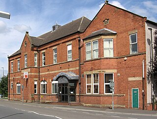
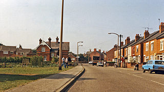
Clowne is a village and civil parish in the Bolsover district of Derbyshire, England. The population at the 2001 Census was 7,447 increasing to 7,590 at the 2011 Census. It forms part of the Bolsover constituency. Clowne lies 9 miles (14 km) north east of Chesterfield and 7 miles (11 km) south west of Worksop. It is mentioned in the Domesday Book as Clune. The name is derived from the Celtic Clun for a river.

<span class="mw-page-title-main">Creswell railway station</span> Railway station in Derbyshire, England

Creswell railway station serves the village Creswell in Derbyshire, England. The station is on the Robin Hood Line between Nottingham and Worksop. It is also the nearest station to the larger village of Clowne.

<span class="mw-page-title-main">Shirebrook railway station</span> Railway station in Derbyshire, England

Shirebrook railway station serves the town of Shirebrook in Derbyshire, England. The station is on the Robin Hood Line, 21½ miles (35 km) north of Nottingham towards Worksop.

Whittington railway station is a former railway station on the southern edge of New Whittington, Derbyshire, England.

<span class="mw-page-title-main">Barrow Hill railway station</span> Former railway station in Derbyshire, England

Barrow Hill railway station is a former railway station in the village of Barrow Hill in northern Derbyshire, England.

The Lancashire, Derbyshire and East Coast Railway (LD&ECR) was built to connect coalfields in Derbyshire and Nottinghamshire with Warrington and a new port on the Lincolnshire coast. It was a huge undertaking, and the company was unable to raise the money to build its line. With the financial help of the Great Eastern Railway it managed to open between Chesterfield and Lincoln with a branch towards Sheffield from 1896. Despite efforts to promote tourist travel, the passenger business was never buoyant, but collieries were connected to the line, at first and in succeeding years. The Great Eastern Railway, and other main line companies, transported coal to the southern counties, and the company's engines took coal to Immingham in great quantities. The company had a fleet of tank engines.

<span class="mw-page-title-main">Arkwright Town railway station</span> Former railway station in Derbyshire, England

Arkwright Town railway station was in Arkwright Town, Derbyshire, England.

<span class="mw-page-title-main">Shirebrook North railway station</span> Former railway station in Derbyshire, England

Shirebrook North railway station was a railway station serving the town of Shirebrook in Derbyshire, England. It was on the Lancashire, Derbyshire and East Coast Railway running from Chesterfield to Lincoln. The starion was also on the former Shirebrook North to Nottingham Victoria Line and the Sheffield District Railway. The station has since been demolished and housing now occupies parts of the site with some stub rails nearby serving a train scrapper.

<span class="mw-page-title-main">Creswell and Welbeck railway station</span> Former railway station in Derbyshire, England

Creswell and Welbeck railway station used to serve the village of Creswell, in north eastern Derbyshire, England.

<span class="mw-page-title-main">Clowne South railway station</span> Former railway station in Derbyshire, England

Clowne South railway station is a former railway station in Clowne, Derbyshire, England.

<span class="mw-page-title-main">Staveley Town railway station</span> Former railway station in Derbyshire, England

Staveley Town is a disused railway station in Staveley, Derbyshire in England.

<span class="mw-page-title-main">Clowne and Barlborough railway station</span> Former railway station in Derbyshire, England

Clowne & Barlborough is a former railway station in Clowne northeast of Chesterfield, Derbyshire, England.

<span class="mw-page-title-main">Bolsover Castle railway station</span> Former railway station in Derbyshire, England

Bolsover Castle is a former railway station in Bolsover, Derbyshire, England.

<span class="mw-page-title-main">Palterton and Sutton railway station</span> Former railway station in Derbyshire, England

Palterton and Sutton is a former railway station between Palterton and Sutton Scarsdale, Derbyshire, England.

<span class="mw-page-title-main">Glapwell railway station</span> Former railway station in Derbyshire, England

Glapwell is a former railway station in Glapwell, Derbyshire, England.

<span class="mw-page-title-main">Rowthorn and Hardwick railway station</span> Former railway station in Derbyshire, England

Rowthorn and Hardwick is a former railway station in Rowthorn, near Glapwell, Derbyshire, England.

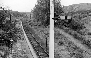
Markland Grips Viaduct is a former railway viaduct south east of Clowne, Derbyshire, England.

The Doe Lea branch is a mothballed railway line in Derbyshire, England. It connected the Derbyshire towns of Chesterfield, Staveley and Bolsover to the Nottinghamshire town of Mansfield. It also had a branch line to Creswell via the Derbyshire town of Clowne.

Beighton Junction is a set of railway junctions near Beighton on the border between Derbyshire and South Yorkshire, England.

References

Notes

  1. Anderson & Cupit 2000, p. 40.
  2. Anderson & Cupit 2000, p. 42.
  3. Kaye 1988, p. 27.
  4. [ 53°15′32.81″N1°20′3.57″W / 53.2591139°N 1.3343250°W Seymour Junction by map and satellite]
  5. Hurst 1987, p. 70.
  6. [ 53°15′55.72″N1°12′59.88″W / 53.2654778°N 1.2166333°W Creswell Junction by map and satellite]
  7. "Clowne Railway Sidings". Picture the Past.
  8. Bower 1993, p. 25.
  9. [ 53°16′10.98″N1°18′15.96″W / 53.2697167°N 1.3044333°W M1 Bridge over Clowne Branch by map and satellite]
  10. Booth 2013, p. 35.
  11. "Engineer's Line References introduction". www.railwaycodes.org.uk.
  12. Hurst 1987, p. 67.
  13. Bradshaw 1985, p. 660.
  14. Kingscott 2007, p. 137.
  15. Hurst 1987, pp. 70&53.
  16. Hurst 1987, p. 79.
  17. DVD 2004.
  18. Hurst 1987, p. 68.
  19. "Oxcroft Disposal Point in late BR days: via wikimedia".
  20. Kelly 1992, p. 5.
  21. Hurst 1987, p. 71.
  22. "Oxcroft Siding No3". www.signalboxes.com.
  23. https://apps.derbyshire.gov.uk/applications/planning-applications/profile.asp?AppType=1&AppCode=CD5/0817/39 [ permanent dead link ]

Sources

Other Reading