
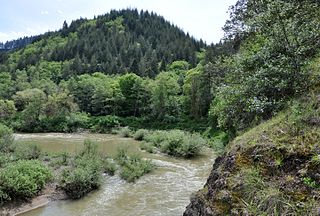
Larrys Creek is a 22.9-mile-long (36.9 km) tributary of the West Branch Susquehanna River in Lycoming County in the U.S. state of Pennsylvania. A part of the Chesapeake Bay drainage basin, its watershed drains 89.1 square miles (231 km2) in six townships and a borough. The creek flows south from the dissected Allegheny Plateau to the Ridge-and-valley Appalachians through sandstone, limestone, and shale from the Devonian, Mississippian, and Pennsylvanian periods.

Mill Creek is a 17.8-mile-long (28.6 km) stream, originating in the San Bernardino Mountains, in San Bernardino County, California. It is a major tributary of the Santa Ana River. Their confluence occurs just downstream of the upper Santa Ana Canyon mouth. Part of the upper creek flows through San Bernardino National Forest, with the headwaters, being in the San Gorgonio Wilderness.
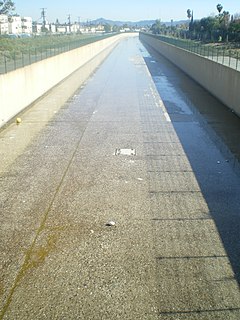
Tujunga Wash is a 13.0-mile-long (20.9 km) stream in Los Angeles County, California. It is a tributary of the Los Angeles River, providing about a fifth of its flow, and drains about 225 square miles (580 km2). It is called a wash because it is usually dry, especially the lower reaches, only carrying significant flows during and after storms, which usually only occur between November and April.
Piru Creek is a major stream, about 71 miles (114 km) long, in northern Los Angeles County and eastern Ventura County, California. It is a tributary of the Santa Clara River, the largest stream system in Southern California that is still relatively natural.

Big Pine Creek is a 12.1-mile-long (19.5 km) stream in Inyo County of eastern California, in the western United States. It flows from the eastern Sierra Nevada down to the Owens Valley, where it is a major tributary of the Owens River near Big Pine.

The Angeles Forest Highway is a road over the San Gabriel Mountains in Los Angeles County, California. It connects the Los Angeles Basin with the Antelope Valley and western Mojave Desert. The highway is also known as County Road N-3 or FH-59 or the Palmdale cutoff; the route numbers are unsigned, but noted on many maps. It is about 25 miles (40 km) long.
The Soque River and its watershed are located entirely within the county boundaries of Habersham County in northeast Georgia. The Soque is a tributary of the Chattahoochee River. Portions of the river run along State Route 197.

The South Fork Kern River is a tributary of the Kern River in the Sierra Nevada of the U.S. state of California. It is one of the southernmost rivers on the western slope of the mountains, and drains a high, relatively dry plateau country of 982 square miles (2,540 km2) along the Sierra Crest. The upper South Fork flows through a series of rugged canyons, but it also drains a flat, marshy valley before joining the Kern River at Lake Isabella.

The North Fork Eel River is the smallest of four major tributaries of the Eel River in northwestern California in the United States. It drains a rugged wilderness area of about 286 square miles (740 km2) in the California Coast Ranges, and flows through national forests for much of its length. Very few people inhabit the relatively pristine watershed of the river; there are no operational stream gauges and only one bridge that crosses the river, near the boundary between Trinity and Mendocino Counties.

The North Fork American River is the longest branch of the American River in Northern California. It is 88 miles (142 km) long from its source at the crest of the Sierra Nevada, near Lake Tahoe, to its mouth at Folsom Lake northeast of Sacramento. Prior to the construction of Folsom Dam the river was about 9 miles (14 km) longer making for a total length of 97 miles (156 km).
The New Fork River is the uppermost major tributary of the Green River in Wyoming, flowing about 70 miles (110 km) entirely within Sublette County. It drains an arid farming region of southwestern Wyoming south of the Wind River Range.

Skillern Peak, at 8,878 feet (2,706 m) above sea level is a peak in the Smoky Mountains of Idaho. The peak is located in Sawtooth National Forest in Camas County. It is located in the watershed of Big Smoky Creek, a tributary of the South Fork of the Boise River. It is about 4.5 mi (7.2 km) northwest of Big Peak and 3.9 mi (6.3 km) southeast of Paradise Peak. No roads or trails go to the summit, although a trail is on the side of the mountain.

Little Rock Creek is a 16.7-mile (26.9 km) northwestward-flowing stream in the San Gabriel Mountains and Mojave Desert, within northern Los Angeles County, California.
The Middle Fork Coquille River is a tributary, about 40 miles (64 km) long, of the South Fork Coquille River in the U.S. state of Oregon. It begins near Camas Mountain in Douglas County in the Southern Oregon Coast Range. It flows generally south, bypassing the community of Camas Valley while passing through the valley of the same name, then curves west and north to Remote in Coos County. The Middle Fork then flows generally west, passes by the small community of Bridge, and meets the South Fork near Myrtle Point. The confluence with the South Fork is 41 miles (66 km) by water to where the main stem of the Coquille River enters the Pacific Ocean at Bandon.

The East Fork is the largest headwater of the San Gabriel River in Los Angeles County, California. It originates at the crest of the San Gabriel Mountains in the Angeles National Forest, at the confluence of the Prairie Fork and Vincent Gulch near Mount Baden-Powell. It then flows south and west for 17 miles (27 km) to San Gabriel Reservoir, where it joins with the West Fork San Gabriel River. Although the East Fork is colloquially considered a separate river, the U.S. Geological Survey officially lists the East Fork as the upper part of the main stem San Gabriel River, a fact is shown by topographical maps of the area.
The North Fork San Gabriel River is a tributary, 4.5 miles (7.2 km) long, of the West Fork San Gabriel River in the Angeles National Forest of Los Angeles County, California. The river originates at the confluence of Soldier Creek and Coldbrook Creek in the San Gabriel Mountains below the village of Falling Springs and flows down a steep canyon in a southerly direction to join the West Fork near San Gabriel Reservoir. The North Fork Canyon provides the route for SR 39, one of the main access roads to the Angeles Forest.

Alder Creek is an approximately 4.25-mile (6.84 km) long tributary of Big Tujunga Creek in Los Angeles County, California and the Angeles National Forest. It is formed by the confluence of the West Fork and North Fork Alder Creek in the San Gabriel Mountains a short distance south of Pacifico Mountain. It then flows south, picking up the Middle Fork, East Fork and Mule Fork before emptying into Big Tujunga Creek 5 miles (8.0 km) east of Hidden Springs. Near its mouth the creek flows under a bridge carrying Upper Big Tujunga Canyon Road.
Last Chance Creek is a major stream, 38 miles long, in Plumas County, California, United States and is part of the Feather River system. It originates near Meadow View Peak in the Diamond Mountains, part of the Sierra Nevada, in the Plumas National Forest about 5 miles (8.0 km) west of Doyle. It flows generally northwest through uninhabited National Forest lands then turns southwest, then due west at the confluence with Squaw Queen Creek. From there it flows west to join with Red Clover Creek, its main tributary, before emptying into Indian Creek east of Genesee. Indian Creek is a tributary of the East Branch of the North Fork Feather River.

The Matilija Wilderness is a 29,207-acre (11,820 ha) wilderness area in Ventura and Santa Barbara Counties, Southern California. It is managed by the U.S. Forest Service, being situated within the Ojai Ranger District of the Los Padres National Forest. It is located adjacent to the Dick Smith Wilderness to the northwest and the Sespe Wilderness to the northeast, although it is much smaller than either one. The Matilija Wilderness was established in 1992 in part to protect California condor habitat.


