List of rivers of California

Last updated

Map of some major California rivers and lakes California rivers.jpg
Map of some major California rivers and lakes

This is a list of rivers in the U.S. state of California, grouped by region. Major lakes and reservoirs, if applicable, are indicated in italics.

Contents

North Coast (north of Humboldt Bay)

Rivers and streams between the Oregon border and Humboldt Bay that empty into the Pacific Ocean (arranged north to south; tributaries with those entering nearest the sea first). Bold indicates rivers with more detailed lists in following sections.

Smith River

Smith River drainage basin Smith River map.png
Smith River drainage basin

Klamath River

Klamath River drainage basin Klamath Basin map.png
Klamath River drainage basin

Trinity River

Trinity River TrinityRiverCA.jpg
Trinity River
Trinity River drainage basin Trinity CA watershed map.png
Trinity River drainage basin
  • Trinity River
    • Mill Creek
    • Tish Tang o Tang Creek
    • Horse Linto Creek
    • Willow Creek
    • South Fork Trinity River
    • Sharber Creek
    • Quinby Creek
    • Hawkins Creek
    • New River
      • Bell Creek
      • Big Creek
      • China Creek
      • Panther Creek
      • Quinby Creek
      • Devils Canyon Creek
      • East Fork New River
      • Slide Creek
      • Virgin Creek
    • Canadian Creek
    • Big French Creek
    • Little French Creek
    • Price Creek
    • Manzanita Creek
    • Big Bar Creek
    • Sailor Bar Creek
    • North Fork Trinity River
      • East Fork North Fork Trinity River
      • Backbone Creek
      • Whites Creek
      • China Creek
      • Rattlesnake Creek
      • Gas Creek
      • Grizzly Creek
    • Canyon Creek
      • Big East Fork Canyon Creek
      • Little East Fork Canyon Creek
    • Oregon Gulch
    • Soldier Creek
    • Dutch Creek
    • Browns Creek
      • Little Creek
    • Reading Creek
    • Weaver Creek
      • Little Browns Creek
      • East Weaver Creek
      • West Weaver Creek
    • Indian Creek
    • Grass Valley Creek
      • Little Grass Valley Creek
    • Rush Creek
    • Deadwood Creek
    • Papoose Creek
    • Stuart Fork
      • Hobel Creek
      • Mule Creek
      • Stoney Creek
      • Owens Creek
      • Deep Creek
      • Boulder Creek
      • Deer Creek
    • Swift Creek
      • Granite Creek
    • East Fork Trinity River
      • Cedar Creek
      • Mumbo Creek
      • Crow Creek
      • Baker Creek
    • Coffee Creek
      • Little Boulder Creek
      • Boulder Creek
      • Sugar Pine Creek
      • East Fork Coffee Creek
      • North Fork Coffee Creek
      • Union Creek
      • South Fork Coffee Creek
    • Scorpion Creek
    • Eagle Creek
    • Ramshorn Creek
    • Bear Creek
    • Tangle Blue Creek
    • Scott Mountain Creek
    • Little Trinity River
    • Sherer Creek
    • Picayune Creek
    • Cedar Creek
    • Bear Creek
    • High Camp Creek

Salmon River

  • Salmon River
    • Merrill Creek
    • Somes Creek
    • Wooley Creek
      • Steinacher Creek
      • Bridge Creek
      • Rock Creek
      • Hancock Creek
      • North Fork Wooley Creek
        • Cuddihy Fork
      • Hell Hole Creek
      • Big Meadows Creek
      • South Fork Wooley Creek
      • Big Elk Fork
    • Butler Creek
    • Morehouse Creek
    • Nordheimer Creek
    • Crapo Creek
    • North Fork Salmon River
      • Little North Fork Salmon River
      • Russian Creek
      • Right Hand Fork North Fork Salmon River
    • South Fork Salmon River
      • Knownothing Creek
      • Methodist Creek
      • Black Bear Creek
      • Plummer Creek
      • St Claire Creek
      • Crawford Creek
      • Cecil Creek
      • East Fork South Fork Salmon River
        • Taylor Creek
      • Rush Creek
      • Little South Fork Salmon River

Redwood Creek

Mad River

Humboldt Bay

Primary streams entering Humboldt Bay are listed north to south beginning north of the entrance to the bay and continuing in a clockwise direction. Tributaries entering nearest the bay are listed first. [1] [2]

For additional detail on Humboldt Bay streams, see Humboldt Bay: Bay tributaries and sloughs.

North Coast (south of Humboldt Bay)

Eel River watershed map Eelrivermap.png
Eel River watershed map
Russian River near Duncan's Mills Wfm russian river.jpg
Russian River near Duncan's Mills

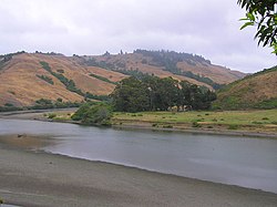
Rivers and streams between Humboldt Bay and the Golden Gate that empty into the Pacific Ocean (arranged north to south; tributaries with those entering nearest the sea first):

For details of the Sonoma and Marin coasts, see List of watercourses in the San Francisco Bay Area.

San Francisco Bay

Streams that empty into San Francisco Bay or its tributary bays (arranged clockwise, starting at the north side of the Golden Gate; tributaries are listed from those entering nearest the bays to farthest). The Central Valley watershed feeding into Suisun Bay via the Sacramento–San Joaquin Delta is excluded; see the following section for the Sacramento and San Joaquin river systems.

For additional detail on Bay Area creeks, see List of watercourses in the San Francisco Bay Area.

San Pablo Bay (north of Carquinez Strait)

Suisun Bay

Clockwise

San Pablo Bay (south of Carquinez Strait) and San Francisco Bay

For additional detail on Bay Area creeks, see List of watercourses in the San Francisco Bay Area.

Sacramento–San Joaquin River Delta

The Sacramento and San Joaquin River systems drain the western slope of the Sierra Nevada and most of the Central Valley, forming the Sacramento–San Joaquin River Delta before emptying into Suisun Bay; together, they are the largest river system in California.

Sacramento River

Map of Sacramento River Sacramento River basin map.png
Map of Sacramento River
Sacramento River near the mouth Sacramento river delta p1080765.jpg
Sacramento River near the mouth
Cache Creek, in the Coast Ranges CacheCreek.jpg
Cache Creek, in the Coast Ranges

Yolo Bypass

Yolo Bypass location Yolo Bypass Schematic Map.jpg
Yolo Bypass location

American River

American River drainage basin Americanrivermap.png
American River drainage basin

Feather River

Feather River drainage basin Feathermap-01.png
Feather River drainage basin
Headwaters of the Feather River FeatherRiver.JPG
Headwaters of the Feather River
Yuba River
Yuba River drainage basin Yubamap-01.png
Yuba River drainage basin

Pit River

Pit River drainage basin Pit River basin map.png
Pit River drainage basin

San Joaquin River

San Joaquin River map San Joaquin River watershed.png
San Joaquin River map
The San Joaquin River San Joaquin River USGS.jpg
The San Joaquin River

Mokelumne River

Mokelumne River drainage basin Mokerivernew.png
Mokelumne River drainage basin

Note: In the Delta the Mokelumne River divides into two short branches, also called the "North Fork" and "South Fork", which recombine before reaching the San Joaquin River.

Calaveras River

  • Calaveras River
    • New Hogan Dam, New Hogan Lake
    • North Fork Calaveras River
      • Murray Creek
      • Jesus Maria Creek
      • Esperanza Creek
    • South Fork Calaveras River
      • Calaveritas Creek
      • San Antonio Creek
      • San Domingo Creek
      • Cherokee Creek

Stanislaus River

Stanislaus River drainage basin Stanislausmap1.png
Stanislaus River drainage basin

Tuolumne River

Tuolumne River drainage basin Tuolumnemap-01.png
Tuolumne River drainage basin

Merced River

Merced River drainage basin Mercedmap-new-01.png
Merced River drainage basin
The Merced River in Yosemite Valley Yosemite nat park valley view.JPG
The Merced River in Yosemite Valley

Tulare Basin

Map of the Tulare Lake Basin Tularebasinmapnew-01.png
Map of the Tulare Lake Basin

Usually an endorheic basin, waters in this region all eventually would reach Tulare Lake. This region would overflow into the San Joaquin River during flood years when Tulare Lake overflowed. Streams are listed clockwise around the Tulare Basin, starting at the Kings River:

Kings River

Kings River drainage basin Kings River watershed.png
Kings River drainage basin

Kaweah River

Kaweah River drainage basin Kaweah river basin.png
Kaweah River drainage basin
Kaweah River in the foothills of the Sierra 2006 12 29 - Terminus Dam (2).JPG
Kaweah River in the foothills of the Sierra

Tule River

Kern River

Location of the Kern River KernRiverMap.png
Location of the Kern River

Central Coast

Rivers that empty into the Pacific Ocean between the Golden Gate and Point Arguello, arranged in order from north to south.

For details of the San Mateo coast, see List of watercourses in the San Francisco Bay Area.

Pajaro River

Salinas River

Salinas River drainage basin Salinas River watershed.png
Salinas River drainage basin

Santa Maria River

Santa Maria River drainage basin Santa maria river map.png
Santa Maria River drainage basin

Santa Ynez River

Santa Ynez River drainage basin Santa ynez river map.png
Santa Ynez River drainage basin

South Coast

Rivers that empty into the Pacific Ocean southeast of Point Arguello, arranged from north to south:

Point Arguello to Santa Monica

Santa Clara River

Santa Clara River drainage basin Santa clara river map.png
Santa Clara River drainage basin

Ventura River

Santa Monica to San Clemente

Los Angeles River

San Gabriel River

Santa Ana River

San Clemente to Mexican border

Santa Margarita River

San Luis Rey River

San Dieguito River

San Diego River

San Diego Bay

Tributaries entering San Diego Bay are arranged from North to South:

Gulf of California

Rivers that empty into the Gulf of California:

Carrizo Plain

The Carrizo Plain is a large enclosed valley near the Central Coast which drains into Soda Lake.

Salton Sea

Rivers that empty into the Salton Sea:

Great Basin

Rivers in the Great Basin, arranged roughly north to south:

Tule Lake

Honey Lake

Honey Lake drainage basin Honey Lake Basin-01.png
Honey Lake drainage basin

Pyramid Lake (in Nevada)

Pyramid Lake drainage basin Truckeerivermap.png
Pyramid Lake drainage basin

Carson Sink (in Nevada)

Carson Sink drainage basin Carsonrivermap.png
Carson Sink drainage basin

Walker Lake (in Nevada)

Mono Lake

Rivers draining into saline and endorheic Mono Lake in eastern California, from north and proceeding counterclockwise:

Owens Lake

Owens Lake drainage basin Owensmap-01.png
Owens Lake drainage basin

Death Valley

Streams terminating in the Badwater Basin in Death Valley National Park.

Antelope Valley-Fremont Valley watersheds

Streams terminating in various dry lakes in the Antelope Valley and Fremont Valley (Koehn Lake, Rosamond Lake, Rogers Dry Lake and others), draining from the southeastern Tehachapi Mountains and northern San Gabriel Mountains, listed counterclockwise starting from north:

Soda Lake (Mojave River drainage)

Mojave River drainage basin Mojaverivermap.png
Mojave River drainage basin

See also

Related Research Articles

<span class="mw-page-title-main">Kings River (California)</span> River in central California, US

The Kings River, is a 132.9-mile (213.9 km) river draining the Sierra Nevada mountain range in central California in the United States. Its headwaters originate along the Sierra Crest in and around Kings Canyon National Park and form the eponymous Kings Canyon, one of the deepest river gorges in North America. The river is impounded in Pine Flat Lake before flowing into the San Joaquin Valley southeast of Fresno. With its upper and middle course in Fresno County, the Kings River diverges into multiple branches in Kings County, with some water flowing south to the old Tulare Lake bed and the rest flowing north to the San Joaquin River. However, most of the water is consumed for irrigation well upstream of either point.

<span class="mw-page-title-main">Kern River</span> Wild And Scenic River in California, United States

The Kern River, previously Rio de San Felipe, later La Porciuncula, is an Endangered, Wild and Scenic river in the U.S. state of California, approximately 165 miles (270 km) long. It drains an area of the southern Sierra Nevada mountains northeast of Bakersfield. Fed by snowmelt near Mount Whitney, the river passes through scenic canyons in the mountains and is a popular destination for whitewater rafting and kayaking. It is the southernmost major river system in the Sierra Nevada, and is the only major river in the Sierra that drains in a southerly direction.

<span class="mw-page-title-main">Yokuts</span> Ethnic group native to the United States

The Yokuts are an ethnic group of Native Americans native to central California. Before European contact, the Yokuts consisted of up to 60 tribes speaking several related languages. Yokuts is both plural and singular; Yokut, while common, is erroneous. 'Yokut' should only be used when referring specifically to the Tachi Yokut Tribe of Lemoore. Some of their descendants prefer to refer to themselves by their respective tribal names; they reject the term Yokuts, saying that it is an exonym invented by English-speaking settlers and historians. Conventional sub-groupings include the Foothill Yokuts, Northern Valley Yokuts, and Southern Valley Yokuts.

<span class="mw-page-title-main">Kaweah River</span> River in the United States of America

The Kaweah River is a river draining the southern Sierra Nevada in Tulare County, California in the United States. Fed primarily by high elevation snowmelt along the Great Western Divide, the Kaweah begins as four forks in Sequoia National Park, where the watershed is noted for its alpine scenery and its dense concentrations of giant sequoias, the largest trees on Earth. It then flows in a southwest direction to Lake Kaweah – the only major reservoir on the river – and into the San Joaquin Valley, where it diverges into multiple channels across an alluvial plain around Visalia. With its Middle Fork headwaters starting at almost 13,000 feet (4,000 m) above sea level, the river has a vertical drop of nearly two and a half miles (4.0 km) on its short run to the San Joaquin Valley, making it one of the steepest river drainages in the United States. Although the main stem of the Kaweah is only 33.6 miles (54.1 km) long, its total length including headwaters and lower branches is nearly 100 miles (160 km).

<span class="mw-page-title-main">San Jacinto River (California)</span> River in California, United States

The San Jacinto River is a 42-mile-long (68 km) river in Riverside County, California. The river's headwaters are in Santa Rosa and San Jacinto Mountains National Monument. The lower portion of the 765-square-mile (1,980 km2) watershed is urban and agricultural land. As a partially endorheic watershed that is contiguous with other Great Basin watersheds, the western side of the San Jacinto Basin is a portion of the Great Basin Divide.

<span class="mw-page-title-main">Fresno River</span> River in California, United States

The Fresno River is a river in Central California and a major tributary of the San Joaquin River. It runs approximately 83 miles (134 km) from the Sierra Nevada Range to the San Joaquin River if measured from the source of Rainier Creek, near Raymond Mountain in Yosemite National Park. Although called the 'Fresno' River, it is one of the largest and longest river systems in Madera County.

The Chowchilla River is a river in central California, United States and a minor tributary of the San Joaquin River. It flows for 54.2 miles (87.2 km) from the western side of the Sierra Nevada Range to the San Joaquin River system in the San Joaquin Valley.

<span class="mw-page-title-main">Tujunga Wash</span> Stream in Los Angeles County, California, US

Tujunga Wash is a 13-mile-long (20.9 km) stream in Los Angeles County, California. It is a tributary of the Los Angeles River, providing about a fifth of its flow, and drains about 225 square miles (580 km2). It is called a wash because it is usually dry, especially the lower reaches, only carrying significant flows during and after storms, which usually only occur between November and April. The name of the wash derives from a Tongva village name.

<span class="mw-page-title-main">Rio Chama</span> River of Colorado and New Mexico in the US

The Rio Chama, a major tributary river of the Rio Grande, is located in the U.S. states of Colorado and New Mexico. The river is about 130 miles (210 km) long altogether. From its source to El Vado Dam its length is about 50 miles (80 km), from El Vado Dam to Abiquiu Dam is about 51 miles (82 km), and from Abiquiu Dam to its confluence with the Rio Grande is about 34 miles (55 km).

<span class="mw-page-title-main">Los Gatos Creek (Santa Clara County)</span> River in California, United States

The Los Gatos Creek runs 24 miles (39 km) in California through Santa Clara Valley Water District's Guadalupe Watershed from the Santa Cruz Mountains northward through the Santa Clara Valley until its confluence with the Guadalupe River in downtown San Jose. The Guadalupe River then continues onward into San Francisco Bay.

<span class="mw-page-title-main">San Diego Creek</span> River in California, United States

San Diego Creek is a 16-mile (26 km) urban waterway flowing into Upper Newport Bay in Orange County, California in the United States. Its watershed covers 112.2 square miles (291 km2) in parts of eight cities, including Irvine, Tustin, and Costa Mesa. From its headwaters in Laguna Woods the creek flows northwest to its confluence with Peters Canyon Wash, where it turns abruptly southwest towards the bay. Most of the creek has been converted to a concrete flood control channel, but it also provides important aquatic and riparian habitat along its course and its tidal estuary.

The Stockton–Los Angeles Road, also known as the Millerton Road, Stockton–Mariposa Road, Stockton–Fort Miller Road or the Stockton–Visalia Road, was established about 1853 following the discovery of gold on the Kern River in Old Tulare County. This route between Stockton and Los Angeles followed by the Stockton–Los Angeles Road is described in "Itinerary XXI. From Fort Yuma to Benicia, California", in The Prairie Traveler: A Hand-book for Overland Expeditions by Randolph Barnes Marcy. The Itinerary was derived from the report of Lieutenant R. S. Williamson on his topographical survey party in 1853, that was in search of a railroad route through the interior of California.

<span class="mw-page-title-main">Cottonwood Creek (Sacramento River tributary)</span> River in Shasta County, United States

Cottonwood Creek is a major stream and tributary of the Sacramento River in Northern California. About 68 miles (109 km) long measured to its uppermost tributaries, the creek drains a large rural area bounded by the crest of the Coast Ranges, traversing the northwestern Sacramento Valley before emptying into the Sacramento River near the town of Cottonwood. It defines the boundary of Shasta and Tehama counties for its entire length. Because Cottonwood Creek is the largest undammed tributary of the Sacramento River, it is known for its Chinook salmon and steelhead runs.

References

  1. Klamath Resource Information System (KRIS), KRIS Humboldt Bay, URL retrieved November 11, 2007
  2. Humboldt Bay Harbor District, Wetlands, Streams, Riparian Areas, and Watershed Areas, URL retrieved November 12, 2007 Archived November 28, 2007, at the Wayback Machine