San Mateo Creek (San Francisco Bay Area)

Last updated
San Mateo Creek
Arroyo De San Mateo,
Arroyo De San Matheo [1]
Gateway Park, San Mateo (44157372251).jpg
San Mateo Creek just downstream of Gateway Park, where the creek passes under the intersection of Third and Humboldt (Aug 2018)
Relief map of California.png
Red pog.svg
Location of the mouth of San Mateo Creek in California
Etymology Saint Matthew
Location
Country United States
State California
Region San Francisco Peninsula
County San Mateo County
Cities Hillsborough, San Mateo
Physical characteristics
Source 
  coordinates 37°35′35″N122°26′59″W / 37.59306°N 122.44972°W / 37.59306; -122.44972
  elevation1,000 ft (300 m)
Mouth  
  coordinates
37°34′30″N122°18′17″W / 37.57500°N 122.30472°W / 37.57500; -122.30472 Coordinates: 37°34′30″N122°18′17″W / 37.57500°N 122.30472°W / 37.57500; -122.30472
  elevation
7 ft (2.1 m)
Length12 mi (19 km)
Discharge 
  location San Francisco Bay
Basin features
Tributaries 
  left San Andreas Creek
  right Laguna Creek, Polhemus Creek

San Mateo Creek (Spanish for: St. Matthew Creek) is a perennial stream whose watershed includes Crystal Springs Reservoir, for which it is the only natural outlet after passing Crystal Springs Dam.

Contents

History

Early survey of San Mateo Creek in 1856 San Mateo Creek.jpg
Early survey of San Mateo Creek in 1856

After discovering San Francisco Bay from Sweeney Ridge on November 4, 1769, the Portolà expedition descended what Portolà called the Cañada de San Francisco, now San Andreas Creek (or possibly San Mateo Creek). "Laguna Grande" is where the party camped (now covered by the Upper Crystal Springs Reservoir). The Laguna Grande place name is also shown on the 1840s diseño del Rancho Cañada de Raymundo [2] and an 1856 plat. [3] The campsite is marked by California Historical Marker No. 94 "Portola Expedition Camp". [4] They camped here a second time on November 12, on their return trip. [5]

Padre Palóu, on an expedition from Mission San Carlos Borromeo (Carmel) to explore the western side of San Francisco Bay led by Captain Fernando Rivera, renamed Portola's Cañada de San Francisco to Cañada de San Andrés on November 30, 1774, it being the feast day of St. Andrew. [6] Palou's name was later applied to the San Andreas fault (misspelled) when the fault was discovered to be the creator of the valley.

In 1776, the expedition led by Captain Juan Bautista de Anza, rather than stay on the coast as Portola had done, followed an inland route from Monterey, California established by Pedro Fages in 1770. De Anza descended the Santa Clara Valley to San Francisco Bay and followed its western shoreline up the peninsula to San Francisco. The de Anza party selected the sites for Mission San Francisco de Asís (Mission Dolores) and the Presidio of San Francisco. De Anza picked up Portola's trail at San Francisquito Creek, following the Cañada de San Andrés north from there. On the return to Monterey, the party camped on the banks of San Mateo Creek on March 29, 1776.

de Anza Expedition's 1776 camp site, CHL no. 47 at Arroyo Court Arroyo Court, aka De Anza Historical Park, San Mateo (50182420207).jpg
de Anza Expedition's 1776 camp site, CHL no. 47 at Arroyo Court

In de Anza's diary on March 29, 1776, he wrote: "Night having fallen, at a quarter past six I went down to the arroyo of San Andreas and to another, that of San Matheo, where it descends to empty into the estuary. There I found in our camp nearly all the men of the village, very friendly, content, and joyful, putting themselves out to serve us in every way, a circumstance which I have noted in all the natives seen from the 26th up to now, but one which I had not experienced theretofore since leaving the people of the Colorado River." [7]

Shortly thereafter, the rest of the de Anza party – families, soldiers, and priests on their way to help establish the presidio and mission – also camped here for three days, June 24–27, 1776. A plaque labelled "California State Historical Landmark No. 47 Anza Expedition Camp" is located at Arroyo Court, one block west on West 3rd Avenue, San Mateo. [8]

Watershed

San Mateo Creek's source elevation is at almost 1,000 feet on Sweeney Ridge from which it flows southeasterly (in a valley east of Cahill Ridge and west of Sawyer Ridge) for 11.2 km (7 mi) before entering the northwest arm of Lower Crystal Springs Reservoir. The northeast arm of Lower Crystal Springs Reservoir is formed by San Mateo Creek's tributary, San Andreas Creek which descends to the Reservoir southeast along the San Andreas Rift. Another tributary, Laguna Creek, flows northwards from Woodside with its source on Edgewood County Park and Natural Preserve, and historically fed Laguna Grande and then joined San Mateo Creek just upstream from Crystal Springs Canyon, where San Mateo Creek turned east to flow through the canyon. Laguna Grande was submerged when an earthen dam (this was the first Crystal Springs Dam) was constructed in 1877, forming Upper Crystal Springs Reservoir. [9] [10] The old earthen dam became a causeway between Upper and Lower Crystal Springs Reservoirs when the latter was formed by Herman Schussler's concrete Crystal Springs Dam, which dammed up San Mateo Creek in 1888 to form the lower reservoir. [11] The causeway is now crossed by Highway 92. In addition to San Mateo Creek and its San Andreas Creek and Laguna Creek tributaries, the waters of Crystal Springs Reservoir consist of runoff from the eastern slopes of the Montara block of the Santa Cruz Mountains and imported Hetch Hetchy Aqueduct water deriving from the Sierra Nevada. The two Crystal Springs lakes and San Andreas Lake used to be known as Spring Valley Lakes for the Spring Valley Water Company which owned them. Lower Crystal Springs Reservoir now covers the town of Crystal Springs which grew up around a resort of the same name. [6]

From the Crystal Springs Dam San Mateo Creek flows generally northeast 8 km (5 mi) through San Mateo where it is partly intermittent and altered, to San Francisco Bay about 1.1 km (0.7 mi) west of the mouth of Seal Slough. [1] This watercourse lies entirely within San Mateo County and flows generally eastward to discharge into San Francisco Bay.

Ecology

A high-pressure natural gas main crosses the creek just below the Crystal Springs Dam. San Mateo Creek with HP gas main.jpg
A high-pressure natural gas main crosses the creek just below the Crystal Springs Dam.
The Ryder Park pedestrian bridge is the last crossing of San Mateo Creek before it flows into the Bay. Ryder Park, San Mateo (42349327490).jpg
The Ryder Park pedestrian bridge is the last crossing of San Mateo Creek before it flows into the Bay.

San Mateo Creek once hosted coho salmon (Oncorhynchus kisutch) as evidenced by specimens collected by Professor Alexander Agassiz of Harvard University in the 1850s and 1860s. [12] [13] He also collected steelhead trout (Oncorhynchus mykiss) from the creek. [14] Historical records indicate that Chinook salmon (Oncorhynchus tshawytscha) occurred in at least two San Francisco Bay Area watersheds, San Mateo Creek in San Mateo County and San Leandro Creek in Alameda County. [14]

Fog drip may play a key role in the precipitation in the upper watershed. On Cahill Ridge, just west of San Mateo Creek and east of Pilarcitos Creek, at an altitude of 1,000 feet, Oberlander measured fog drip beneath tanoak (Lithocarpus densiflorus), coast redwood and three Douglas fir trees, the latter 125 feet tall. He found that the trees most exposed produced the most precipitation and in five weeks of measurement (July 20-August 28, 1951) fog drip below the tanoak produced 59 inches of precipitation, more than the total annual precipitation on nearby grasslands and chaparral. The Douglas fir produced 7-17 inches of fog drip and appeared to provide unique conditions supporting the orchids giant helleborine (Epipactis gigantea) and phantom orchid (Cephalanthera austiniae), since these plants were found exclusively in these moist ridge tops. [15]

The upper reach of the lower watershed of San Mateo Creek below Crystal Springs Dam consists of open space and sparsely developed residential areas of the cities of Hillsborough and San Mateo, California. This upper reach consists of closed canopy California oak woodland and serpentine grassland. The creek roughly parallels Crystal Springs Road through this section. Due to the unusual microclimate and presence of abundant serpentine there are an unusual number of rare plants in the upper catchment basin. [16]

The middle reach consists of increasingly dense single family and multifamily residential land use along with some adjacent school, park and commercial uses. In the lower phase of the middle reach, San Mateo Creek is fully culverted through downtown San Mateo. In the lowest reach San Mateo Creek becomes tidal and discharges to San Francisco Bay between Ryder Park and Seal Point Park.

The creek mouth area contains slough and wetland habitats including mudflats that are known habitat of the endangered California clapper rail. San Mateo Creek was federally designated in 2002 as a section 303 impaired watershed for the substance diazinon; [17] however, diazinon has been banned for golf course use by the U.S. Government. There is one golf course that provides surface runoff to San Mateo Creek in the city of San Mateo, and Crystal Springs Golf Course that drains to the Crystal Springs Reservoir.

See also

Related Research Articles

Filoli

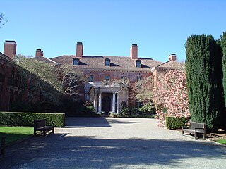
Filoli, also known as the Bourn-Roth Estate, is a country house set in 16 acres (6.5 ha) of formal gardens surrounded by a 654-acre (265 ha) estate, located in Woodside, California, about 25 miles (40 km) south of San Francisco, at the southern end of Crystal Springs Reservoir, on the eastern slope of the Santa Cruz Mountains. Now owned by the National Trust for Historic Preservation, Filoli is open to the public. The site is both a California Historical Landmark and listed on the National Register of Historic Places.

Guadalupe River (California)

The Guadalupe River mainstem is an urban, northward flowing 14 miles (23 km) river in California whose much longer headwater creeks originate in the Santa Cruz Mountains. The river mainstem now begins on the Santa Clara Valley floor when Los Alamitos Creek exits Lake Almaden and joins Guadalupe Creek just downstream of Coleman Road in San Jose, California. From here it flows north through San Jose, where it receives Los Gatos Creek, a major tributary. The Guadalupe River serves as the eastern boundary of the City of Santa Clara and the western boundary of Alviso, and after coursing through San José, it empties into south San Francisco Bay at the Alviso Slough.

Coyote Creek (Santa Clara County)

Coyote Creek is a river that flows through the Santa Clara Valley in California, United States.

Stevens Creek (California)

Stevens Creek is a creek in Santa Clara County, California. The creek originates in the Santa Cruz Mountains on the western flank of Black Mountain in the Monte Bello Open Space Preserve near the terminus of Page Mill Road at Skyline Boulevard. It flows southeasterly through the Stevens Creek County Park before turning northeast into Stevens Creek Reservoir. It then continues north for 12.5 miles through Cupertino, Los Altos, Sunnyvale and Mountain View before emptying into the San Francisco Bay at the Whisman Slough, near Google's main campus.

Alameda Creek

Alameda Creek is a large perennial stream in the San Francisco Bay Area. The creek runs for 45 miles (72 km) from a lake northeast of Packard Ridge to the eastern shore of San Francisco Bay by way of Niles Canyon and a flood control channel.

Crystal Springs Reservoir

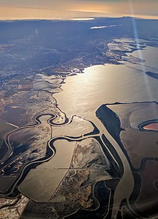
Crystal Springs Reservoir is a pair of artificial lakes located in the northern Santa Cruz Mountains of San Mateo County, California situated in the rift valley created by the San Andreas Fault just to the west of the cities of San Mateo and Hillsborough, and I-280. The lakes are part of the San Mateo Creek watershed.

Sawyer Camp Trail

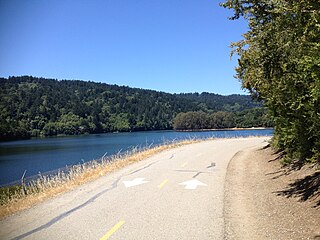
Sawyer Camp Trail is a popular 6-mile (9.7 km) trail located in the San Andreas Fault rift valley in San Mateo County, California near Hillsborough and the San Mateo Highlands. Officially, it is a segment of the longer Crystal Springs Regional Trail. Approximately 300,000 people use the trail every year. It provides excellent views of San Francisco Peninsula's Crystal Springs Watershed. The trail is managed by San Mateo County and totally surfaced in asphalt. There is considerable biodiversity along the trail due to the variation in habitat and the presence of serpentine soils. In particular the plant communities of Northern coastal scrub, grassland and California oak woodland are present.

San Andreas Lake

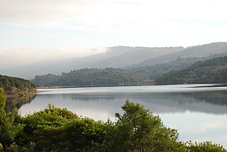
San Andreas Lake is a reservoir adjacent to the San Francisco Peninsula cities of Millbrae and San Bruno in San Mateo County, California. It is situated directly on the San Andreas Fault, which is named after the valley it is in.

San Francisquito Creek

San Francisquito Creek is a creek that flows into southwest San Francisco Bay in California, United States. Historically it was called the Arroyo de San Francisco by Juan Bautista de Anza in 1776. San Francisquito Creek courses through the towns of Portola Valley and Woodside, as well as the cities of Menlo Park, Palo Alto, and East Palo Alto. The creek and its Los Trancos Creek tributary define the boundary between San Mateo and Santa Clara counties.

San Leandro Creek

San Leandro Creek is a 21.7-mile-long (34.9 km) year-round natural stream in the Oakland Hills, in Alameda County and Contra Costa County of the East Bay in northern California.

Pilarcitos Creek is a 13.5-mile-long (21.7 km) coastal stream in San Mateo County, California, United States, that rises on the western slopes of the Santa Cruz Mountains and descends through Pilarcitos Canyon to discharge into the Pacific Ocean Half Moon Bay State Beach.

Wildcat Creek (California)

Wildcat Creek is a 13.4-mile-long (21.6 km) creek which flows through Wildcat Canyon situated between the Berkeley Hills and the San Pablo Ridge, emptying into San Pablo Bay in Contra Costa County, northern California.

Searsville Dam Dam in San Mateo County, California, USA

Searsville Dam is a masonry dam in San Mateo County, California that was completed in 1892, one year after the founding of Stanford University, and impounds Corte Madera Creek to form a reservoir known as Searsville Lake. Searsville Dam is located in the Jasper Ridge Biological Preserve and is owned and operated by Stanford University. Neighboring cities include Woodside and Portola Valley, California.

Corte Madera Creek (San Mateo County) river in the United States of America

Corte Madera Creek is a 7.3-mile-long (11.7 km) creek that flows north-northwest to Searsville Dam and then joins with Bear Creek to form San Francisquito Creek in California.

San Lorenzo Creek

San Lorenzo Creek is a 10.7-mile-long (17.2 km) year-round natural stream flowing through Hayward, California, into San Francisco Bay at the Hayward Regional Shoreline.

Martin Creek, known locally as Dennis Martin Creek, is a 1.4-mile-long (2.3 km) north by northeastward-flowing stream originating just east of Skyline Boulevard in the Santa Cruz Mountains, near the community of Skylonda in San Mateo County, California. It flows through the town of Woodside before joining Sausal Creek on Stanford University lands just across the border from Woodside. Sausal Creek enters Searsville Reservoir, which flows to San Francisco Bay via San Francisquito Creek.

San Andreas Creek

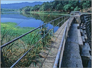
San Andrés Creek, now called San Andreas Creek, is a perennial stream that flows 5.9 miles (9.5 km) southeasterly along the San Andreas Fault from Sweeney Ridge in San Mateo County, California, providing the inflow to and outflow from San Andreas Reservoir, and then entering Lower Crystal Springs Reservoir, where it was a historic tributary to San Mateo Creek. San Mateo Creek then carries its waters over Crystal Springs Dam northeast to San Francisco Bay.

Laguna Creek (San Mateo County)

Laguna Creek is a perennial stream that flows northwesterly for 2.6-mile (4.2 km) along the San Andreas Fault from Woodside in San Mateo County, California and, after crossing the Phleger Estate and Filoli, enters Upper Crystal Springs Reservoir, where it is a historic tributary to San Mateo Creek. San Mateo Creek then carries its waters over Crystal Springs Dam northeast to San Francisco Bay.

Alambique Creek River in San Mateo County, California, United States

Alambique Creek, or Arroyo Alembique, is a 2.7-mile-long (4.3 km) stream located in San Mateo County, California in the United States. It is part of the San Francisquito Creek watershed.

Sausal Creek is a 2.5-mile-long (4.0 km) northwesterly-flowing stream originating in Portola Valley along the northeastern edge of the Windy Hill Open Space Preserve in the eastern foothills of the Santa Cruz Mountains, in San Mateo County, California, United States. It joins a nexus of creeks becoming Corte Madera Creek in a natural marsh above Searsville Reservoir on Stanford University lands. Below Searsville Reservoir, Corte Madera Creek joins with Bear Creek to form San Francisquito Creek and flows to San Francisco Bay.

References

  1. 1 2 U.S. Geological Survey Geographic Names Information System: San Mateo Creek
  2. "Diseño del Rancho Cañada de Raymundo". Calisphere, University of California. Retrieved 2011-10-09.
  3. Erwin Gustav Gudde (1974). California Place Names. University of California Press. p. C-261. Retrieved 2011-10-09.
  4. "California Historical Landmarks". California State Parks Office of Historic Preservation. Retrieved 2011-10-09.
  5. "California Historical Landmarks". California Office of Historic Preservation. Retrieved 2010-07-13.
  6. 1 2 David L. Durham (1998). California's geographic names: a gazetteer of historic and modern names of the state. Quill Driver Books. p. 694. ISBN   978-1-884995-14-9 . Retrieved 2010-07-13.
  7. de Anza; Juan Bautista (1776). Diary of Juan Bautista de Anza October 23, 1775 – June 1, 1776. University of Oregon Web de Anza pages. Retrieved 2010-07-13.
  8. "California Historical Landmarks". California Office of Historic Preservation. Retrieved 2010-07-13.
  9. David L. Durham (1998). California's geographic names: a gazetteer of historic and modern names of the state. Quill Driver Books. p. 658. ISBN   978-1-884995-14-9 . Retrieved 2010-07-13.
  10. Alan Hynding (1982). From Frontier to Suburb, The Story of the San Francisco Peninsula. Belmont, California: Star Publishing Company. p. 75. ISBN   978-0-89863-056-5.
  11. Ferol Egan (1998). Last bonanza kings: the Bourns of San Francisco. University of Nevada Press. p. 167. ISBN   978-0-87417-319-2 . Retrieved 2011-10-11.
  12. Robert A. Leidy; Gordon Becker; Brett N. Harvey (2005). "Historical Status of Coho Salmon in Streams of the Urbanized San Francisco Estuary, California" (PDF). California Fish and Game: 219–254. Retrieved 2011-09-19.
  13. "Oncorhynchus kisutch". Harvard Museum of Comparative Zoology. Retrieved 2010-10-28.
  14. 1 2 Robert A. Leidy (April 2007). Ecology, Assemblage Structure, Distribution, and Status of Fishes in Streams Tributary to the San Francisco Estuary, California (Report). San Francisco Estuary Institute. Retrieved 2010-10-21.
  15. G. T. Oberlander (October 1956). "Summer Fog Precipitation on the San Francisco Peninsula". Ecology. 37 (4): 851–852. doi:10.2307/1933081. JSTOR   1933081.
  16. Environmental Impact Report for the Hillsborough Highlands Estates, Earth Metrics Report 7803 (Report). California State Clearinghouse. November 1989.
  17. Federal impairment profile for San Mateo Creek (PDF) (Report). June 2006. Retrieved 2010-07-11.