Point Isabel is a hilltop in the ancient range of hills that also includes Albany Hill, Brooks Island, and the Potrero San Pablo. Rising sea levels following the last Ice Age formed San Francisco Bay and left the point as a rocky promontory joined to the mainland by a salt marsh that flooded at high tides. A large shell midden showed that Native Americans used the site, specifically the Huchiun Indians.[2]
In the 19th Century, Point Isabel was part of the Rancho San Pablo owned by Don Victór Castro whose father received it in a land grant from the Mexican Republic.[3] Victor Castro named the point for his daughter Isabel. He used it as a landing for boats shipping grain and other articles across the Bay. Castro also built a landing, slaughterhouse, and a hotel on this site.[4] After the United States took control of California, Castro was forced to sell much of his land.[4] Minna Quilfeldt purchased 500 acres around this land in the 1850s. Her husband, Richard Stege, used the land to raise bullfrogs and develop a resort.[4] In later years, the land was acquired by the Du Pont subsidiary Vigoret Powder Works of San Francisco, which used it primarily to store explosives.[3] A wharf and railroad spur served the Vigoret site.[3]
In the early 20th century, "training walls" were built in this area in order to keep channels open, which resulted in a marsh developing behind these walls. This provided habitats for shorebirds and waterbirds.[4] Around the same time, Stauffer Chemical began making sulfuric acid in the area. This site continued its manufacturing until 1997. Chemicals exposed in this area include arsenic, lead, mercury, benzene, acetone, PCBs, mercury, and many others.[4] In the 1930s, the San Pablo Avenue Sportsmen’s Club used Point Isabel for fishing and duck hunting.[4] During World War II, the Navy used Point Isabel as a shooting range.[4]
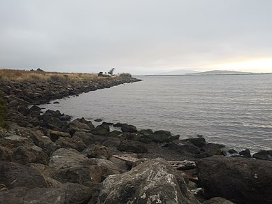
The original hilltop, significantly higher than the present elevation, was dynamited for development in the 1950s. The rubble was used to fill marshlands, widening the point and connecting it to the mainland. A dump for industrial waste filled tidelands north of the original point, separated from it by a tidal channel draining Hoffmann Marsh. This area became known as "Battery Point" because of the large number of batteries buried there.[citation needed] Industrial uses from pesticide manufacturing to waste oil recycling, as well as a pistol range, left the land north and east of Point Isabel among the most polluted brownfield sites along San Francisco Bay, although some of these have been remediated. In recent years, part of the original point, Hoffman Marsh to the east, and later Battery Point were acquired by the East Bay Regional Parks District for its Point Isabel Regional Shoreline, and also by the State of California for its Eastshore State Park.[citation needed] .
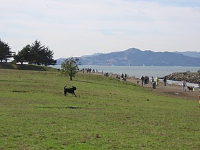
Point Isabel Dog Park
Environmental concerns
A portion of Point Isabel, locally known as TEPCO beach, is covered in thousands of pieces of broken ceramic dishware.[5] The Technical Porcelain and Chinaware Company (TEPCO) was founded in 1918 and grew substantially until the death of its founder, John Pagliero, in 1968.[5] During the span of these fifty years, TEPCO discarded their broken dishware along the banks of Point Isabel.
Point Isabel served as a dumping ground for lead-filled battery casings, thus creating toxic emissions from within the soil.[6] Thousands of tons of soil was removed from this site in the 1970s and 1980s, which was supposed to have resolved the issue. However, in 2018, lead leaks have proved that the job was not entirely completed in the 1970s and 1980s.[6] The source of the recent lead leaks has not been discovered.[6]
Richmond is a city in western Contra Costa County, California, United States. The city was incorporated on August 3, 1905, and has a city council. Located in the San Francisco Bay Area's East Bay region, Richmond borders San Pablo, Albany, El Cerrito and Pinole in addition to the unincorporated communities of North Richmond, Hasford Heights, Kensington, El Sobrante, Bayview-Montalvin Manor, Tara Hills, and East Richmond Heights, and for a short distance San Francisco on Red Rock Island in the San Francisco Bay.
San Pablo is an enclave city in Contra Costa County, California, United States. The population was 32,127 at the 2020 census. The current Mayor is Patricia Ponce. Currently, the City Council consists of Abel Pineda, Arturo Cruz, Elizabeth Pabon-Alvarado, and Rita Xavier. Ponce is Mayor, and Cruz, Pabon-Alvarado, and Xavier are Council Members. Dorothy Gantt is the city Clerk. Viviana Toledo is the city Treasurer.
Point Pinole Regional Shoreline is a regional park on the shores of the San Pablo Bay, California, in the United States. It is approximately 2,315 acres (9.37 km2) in area, and is operated by the East Bay Regional Park District. It includes the Dotson Family Marsh and the Point Pinole Lagoon and hosts the North Richmond Shoreline Festival.
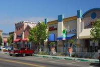
El Cerrito Plaza is a shopping center in El Cerrito, California, a suburb in the San Francisco Bay Area.
Hilltop District, more commonly known simply as Hilltop, is a neighborhood located in the northeastern area of Richmond, California.
Richmond Heights, formerly East Richmond and also known as Mira Vista, is a district of eastern Richmond, California, in the San Francisco Bay Area.
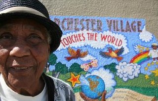
Parchester Village is a planned majority African-American village in northwestern Richmond, California that was the first in the state to sell to blacks.
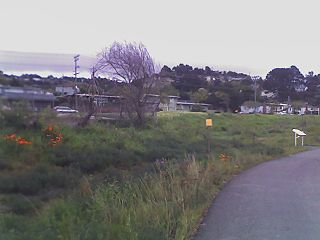
Point Isabel Regional Shoreline in Richmond, California, is operated by East Bay Regional Park District, and is a multi-use park for joggers, windsurfers, kayakers, photographers, picnickers, and people walking dogs. It has access for pedestrians and via public transit, private vehicles, and bikes. It also features a concession offering food for people and grooming for pets. A longtime community organization and nonprofit, Point Isabel Dog Owners and Friends (PIDO), is active in the maintenance and improvement of the park.
Baxter Creek or Stege Creek, is a three-branch creek in Richmond and El Cerrito, California, United States, forming the Baxter Creek watershed. The creek has three sources and flows from the Berkeley Hills to Stege Marsh and the San Francisco Bay. The Baxter Creek watershed at-large has 10 sources.
Cerrito Creek is one of the principal watercourses running out of the Berkeley Hills into San Francisco Bay in northern California. It is significant for its use as a boundary demarcation historically, as well as presently. In the early 19th century, it separated the vast Rancho San Antonio to the south from the Castro family's Rancho San Pablo to the north. Today, it marks part of the boundary between Alameda County and Contra Costa County. The main stem, running through a deep canyon that separates Berkeley from Kensington, is joined below San Pablo Avenue by a fan of tributaries, their lower reaches mostly in culverts. The largest of these is Middle or Blackberry Creek, a southern branch.
Fluvius Innominatus or Central Creek is a stream in Richmond and El Cerrito, California, in western Contra Costa County. There is one main source and a secondary unnamed tributary. The creek drains into Hoffman Marsh and then flows into the bay through Point Isabel Regional Shoreline's Hoffman Channel. However, before the area was developed and as early as 1899 the creek had as many as 11 sources which stretched far higher into the Berkeley Hills.
Castro Creek is a creek in Richmond, California, in the western part of the city adjacent to the Chevron Oil Refinery. Wildcat Creek drains into it directly and though other Wildcat Marsh tributaries into Castro Cove of San Pablo Bay. The creek drains from the drainage basin of the surrounding area and was once part of the channel that separated the island of Point Richmond with the mainland.
Don Víctor Ramón Castro was a Californio ranchero, politician, and businessman. He was one of the largest landowners in Contra Costa and served as a Contra Costa County Supervisor. He operated one of the first ferries in the Bay Area.
San Pablo Peninsula is a peninsula in western Richmond, between San Pablo Bay and San Rafael Bay, in southwestern Contra Costa County, California.
Hoffman Marsh is a wetlands on San Francisco Bay in Richmond, California. The marsh has been protected within Eastshore State Park, and adjacent to Point Isabel Regional Shoreline. The marsh is an important nesting ground for wildfowl and stopping ground on the Pacific Flyway, as it is one of only a handful of undestroyed wetlands in the Bay Area. It borders Point Isabel Regional Shoreline and Interstate 80.
Hercules Transit Center is a major commuter hub in the western Contra Costa County city of Hercules, California. It is anchored by WestCAT bus services. The center was originally on San Pablo Avenue. In August 2009, the transit center was relocated to the other side of I-80 with additional paid parking, which is $3/day.
Fleming Point is a rocky promontory in the U.S. state of California. The rocky promontory is part of a band of rock, that geologists call the Novato Terrane. Which has been formed through titanic clashes of plates that have pulled the rock upwards. This area is the only original existing shoreline in the East Bay Region today. It is situated in Albany, on the eastern shore of San Francisco Bay. Albany Bulb is an extension of the point, having been formed in the 1960s from construction debris.
Citizens for East Shore Parks (CESP) is a United States environmental organization that focuses on the acquisition and preservation of parkland in the San Francisco Bay Area. CESP works to protect open space along the East Bay shoreline for natural habitat and recreational purposes through a combination of advocacy, education, and outreach. Since its founding in 1985, CESP has worked to secure approximately 1,800 acres (730 ha) of public land, primarily through the creation of the 8.5-mile (13.7 km) long Eastshore State Park in 2002.
Chelsea Wetlands is a riparian marsh on lower Pinole Creek and a tidal wetland at its mouth on San Pablo Bay, in Contra Costa County, northern California. It is located within the city of Hercules, in the East Bay region of the San Francisco Bay Area.
Abella Center formerly International Marketplace and originally El Portal Shopping Center is a mixed-use city services, business, shopping center and housing village transit-oriented development that was formerly a mall in San Pablo, California.
This page is based on this Wikipedia article Text is available under the CC BY-SA 4.0 license; additional terms may apply. Images, videos and audio are available under their respective licenses.