Belmont Slough

Last updated
Belmont Slough
Brewer Island, USGS, current.png
Satellite view of Foster City / Brewer Island, which is separated from the mainland by Seal Slough (to the west) and Belmont Slough (to the east/south). The Redwood Shores peninsula is just visible in the southeast corner, with Steinberger Slough separating it from Bair Island.
United States San Francisco Bay Area location map.svg
Red pog.svg
Relief map of California.png
Red pog.svg
Location
CountryUnited States
StateCalifornia
Physical characteristics
Source 
  coordinates 37°33′15″N122°14′40″W / 37.5541020°N 122.2444110°W / 37.5541020; -122.2444110 [1]

Belmont Slough is a slough on the western shore of San Francisco Bay [2] separating Redwood Shores and Foster City. [3] It provides estuarine and marine deepwater habitats in its subtidal waters, which are characterized as brackish and saltwater.

Contents

Course

Near the head of Belmont Slough, as seen from Oracle Bridge in 2013, Redwood Shores, Redwood City, California. Belmont Slough February 2013.jpg
Near the head of Belmont Slough, as seen from Oracle Bridge in 2013, Redwood Shores, Redwood City, California.

The head of the slough is in Belmont, California, just east of U.S. Route 101, slightly north of the exit for Ralston Avenue / Marine Parkway. The slough takes a winding course generally northeast from there, passing to the north of the Redwood Shores Oracle campus (completed in 1989, formerly Marine World/Africa USA) [4] and south of Port Royal Park in Foster City. From there, the slough turns almost directly north, then east, then north again, and finally northeast as it enters the tidal exchange zone with the San Francisco Bay, an area characterized by shallow mudflats.

Both the Foster City and Redwood Shores shorelines of Belmont Slough are protected by the California Department of Fish and Wildlife as the 268-acre (108 ha) Redwood Shores Ecological Reserve, which is northwest of the adjacent Don Edwards San Francisco Bay National Wildlife Refuge and Bair Island Ecological Reserve. [5]

History

Belmont Slough (1970), view directed southwest. This was taken before the development of Redwood Shores (east of the Slough, on the left side of this photograph) and Foster City (west / right). The southern tip of Bat Ray Island is visible within the Slough. Redwood Shores Belmont Slough October 1970 R Forrester.jpg
Belmont Slough (1970), view directed southwest. This was taken before the development of Redwood Shores (east of the Slough, on the left side of this photograph) and Foster City (west / right). The southern tip of Bat Ray Island is visible within the Slough.

In the early 1900s the slough was considered the best place to hunt ducks in San Mateo County, with the birds so plentiful, hunters could sneak up on them. [6]

Foster City established the slough as a nature preserve in 1973. [7] The main route of the San Francisco Bay Trail runs along the perimeter of Foster City, including the western border along Belmont Slough. [8] The city maintains several spur trails off the Bay Trail along the western shore of Belmont Slough, including trails that lead to a beach area and the Foster City sign, visible from aircraft landing at nearby San Francisco International Airport. The intake structure for the Foster City Lagoon, which provides flood control and recreational opportunities for the city, is at the western end of Angelo Slough; Angelo Slough is a stub waterway connected to Belmont Slough running east–west, just north of Bat Ray Island. [9] :10,20

The California State Lands Commission acquired the shoreline areas along Belmont Slough in an exchange with Mobil Oil Corporation in 1976. [5]

Ecology

The salt marshes surrounding Belmont Slough contain stands of cordgrass and pickleweed and serve as feeding areas for rails, herons, and other shorebirds; the levees built to reclaim the land for Foster City and Redwood Shores host gum plant, which provides nesting grounds for the Bay salt marsh song sparrow. Small rodents that live in the area are predated upon by the white-tailed kite, short-eared owl, and marsh harrier. [5] Other animals that may be found near Belmont Slough include the California black rail, California clapper rail, Western snowy plover, Alameda song sparrow, and pallid bat. [10] :Fig.4.3-5

See Also

Related Research Articles

<span class="mw-page-title-main">San Francisco Bay</span> Shallow estuary on the coast of California, United States

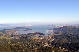
San Francisco Bay is a large tidal estuary in the U.S. state of California, and gives its name to the San Francisco Bay Area. It is dominated by the cities of San Francisco, San Jose, and Oakland.

<span class="mw-page-title-main">San Francisco Peninsula</span> Peninsula in the San Francisco Bay Area

The San Francisco Peninsula is a peninsula in the San Francisco Bay Area that separates San Francisco Bay from the Pacific Ocean. On its northern tip is the City and County of San Francisco. Its southern base is Los Altos, Mountain View, in Santa Clara County, south of Palo Alto and north of Sunnyvale and Los Altos. Most of the Peninsula is occupied by San Mateo County, between San Francisco and Santa Clara counties, and including the cities and towns of Atherton, Belmont, Brisbane, Burlingame, Colma, Daly City, East Palo Alto, El Granada, Foster City, Hillsborough, Half Moon Bay, La Honda, Loma Mar, Los Altos, Menlo Park, Millbrae, Mountain View, Pacifica, Palo Alto, Pescadero, Portola Valley, Redwood City, San Bruno, San Carlos, San Mateo, South San Francisco, and Woodside.

<span class="mw-page-title-main">San Mateo County, California</span> County in California, United States

San Mateo County, officially the County of San Mateo, is a county in the U.S. state of California. As of the 2020 census, the population was 764,442. Redwood City is the county seat, the third-most populated city in the county after Daly City and San Mateo.

<span class="mw-page-title-main">Redwood City, California</span> City in the United States

Redwood City is a city on the San Francisco Peninsula in Northern California's Bay Area, approximately 27 miles (43 km) south of San Francisco, and 24 miles (39 km) northwest of San Jose. Redwood City's history spans its earliest inhabitation by the Ohlone people to being a port for lumber and other goods. The county seat of San Mateo County in the heart of Silicon Valley, Redwood City is home to several global technology companies including Oracle, Electronic Arts, Evernote, Box, and Informatica. The city's population was 84,292 according to the 2020 census. The Port of Redwood City is the only deepwater port on San Francisco Bay south of San Francisco.

<span class="mw-page-title-main">Redwood Shores, California</span> Place in California, United States

Redwood Shores is a waterfront community in Redwood City, California, along the western shore of San Francisco Bay on the San Francisco Peninsula in San Mateo County. Redwood Shores is the home of several major technology companies, including Oracle Corporation, Electronic Arts, Nintendo, Zuora, Qualys, Crystal Dynamics and Shutterfly.

<span class="mw-page-title-main">San Carlos Airport (California)</span> Municipal airport in San Carlos, California, United States

San Carlos Airport is a public airfield located two miles northeast of San Carlos, California, in San Mateo County and serves the San Francisco Bay Area.

<span class="mw-page-title-main">Point Pinole Regional Shoreline</span> Regional park in San Pablo Bay, California

Point Pinole Regional Shoreline is a regional park on the shores of the San Pablo Bay, California, in the United States. It is approximately 2,315 acres (9.37 km2) in area, and is operated by the East Bay Regional Park District. It includes the Dotson Family Marsh and the Point Pinole Lagoon and hosts the North Richmond Shoreline Festival.

<span class="mw-page-title-main">Don Edwards San Francisco Bay National Wildlife Refuge</span> United States National Wildlife Reserve in San Francisco Bay

Don Edwards San Francisco Bay National Wildlife Refuge (DESFBNWR) is a United States National Wildlife Refuge located in the southern part of San Francisco Bay, California. Its headquarters and visitor center are in the Baylands district of Fremont, next to Coyote Hills Regional Park, in Alameda County. The visitor center is on Marshlands Rd, off Thornton Ave.

<span class="mw-page-title-main">Bair Island</span> Swamp in Redwood City, San Mateo County, United States

Bair Island is a marsh area in Redwood City, California, covering 3,000 acres (1,200 ha), and includes three islands: Inner, Middle and Outer islands. Bair Island is part of the larger Don Edwards San Francisco Bay National Wildlife Refuge. It is surrounded by the Steinberger slough to the northwest and Redwood Creek to the southeast.

<span class="mw-page-title-main">Richardson Bay</span> Arm of San Francisco Bay

Richardson Bay is a shallow, ecologically rich arm of San Francisco Bay, managed under a Joint Powers Agency of four northern California cities. The 911-acre (369 ha) Richardson Bay Sanctuary was acquired in the early 1960s by the National Audubon Society. The bay was named for William A. Richardson, early 19th century sea captain and builder in San Francisco. It contains both Strawberry Spit and Aramburu Island.

<span class="mw-page-title-main">Ridgway's rail</span> Species of bird

Ridgway's rail is a species of bird found principally along the Pacific coast of North America from the San Francisco Bay Area to southern Baja California, as well as in some regions of the Gulf of California. A member of the rail family, Rallidae, it is a chicken-sized bird that lives brackish tidal marshes and rarely flies. Its name commemorates American ornithologist Robert Ridgway.

<span class="mw-page-title-main">Marine World/Africa USA</span> Zoo in California, United States

Marine World/Africa USA was an animal theme park located in the Redwood Shores area of Redwood City, California. The park was named Marine World when it first opened in 1968, before merging with a land-animal park called Africa USA in 1972. In 1986, the park relocated to Vallejo, California, and is now known as Six Flags Discovery Kingdom.

<span class="mw-page-title-main">Seal Slough</span>

Seal Slough, also known as Marina Lagoon, is a narrow winding tidal channel through a tidal marsh in San Mateo and Foster City, California. This slough has been the object of a wetland restoration project in recent years to enhance habitat value. Dredging has been carried out in Seal Slough since at least 1954. When the original sewage treatment plant for the city of San Mateo was constructed in 1935, its discharge was directed to Seal Slough.

<span class="mw-page-title-main">Port of Redwood City</span> Port in the San Francisco Bay

The Port of Redwood City is a marine freight terminal on the western side of the southern San Francisco Bay, on the West Coast of the United States. This marine terminal is situated within the city of Redwood City, California. The port was developed from a natural deepwater channel discovered in the year 1850, at the mouth of Redwood Creek. From the early use as a log float port, commercial use expanded to a variety of industrial commodities; moreover, it is considered the birthplace of shipbuilding on the North American west coast. As of 2004 the annual freight shipments have reached about two million metric tons. The Port of Redwood City provides berths for dry bulk, liquid bulk, and project cargoes, along with certain recreational opportunities and public access to San Francisco Bay.

<span class="mw-page-title-main">Moss Landing Wildlife Area</span> California State wildlife preserve

Moss Landing Wildlife Area is a California State wildlife preserve on the shore of Elkhorn Slough.

<span class="mw-page-title-main">Eden Landing Ecological Reserve</span> Nature reserve in Hayward and Union City, California

Eden Landing Ecological Reserve is a nature reserve in Hayward and Union City, California, on the eastern shore of San Francisco Bay. The reserve is managed by the California Department of Fish and Game and comprises 5,040 acres of former industrial salt ponds now used as a low salinity waterbird habitat.

<span class="mw-page-title-main">Greco Island</span> Island in California, United States

Greco Island is a wetland island in Redwood City, California. Greco Island is part of the larger Don Edwards San Francisco Bay National Wildlife Refuge. Westpoint Slough follows the South side of the island while Redwood Creek is along the West. The San Francisco Bay bounds the North and East sides of the island.

<span class="mw-page-title-main">Brewer Island</span> Island in California

Brewer Island is an island in the San Francisco Bay, in San Mateo County, California. Originally owned by W. P. A. Brewer, for over one hundred years it was used for hay farming. Several attempts to develop the island failed between 1912 and 1959. Ultimately, a venture by Richard Grant and T. Jack Foster succeeded in 1960; Brewer Island's surface was raised by 6 ft (1.8 m), an artificial lake was dug in its center, and it became the location of what is now known as Foster City.

<span class="mw-page-title-main">Bird Island (San Mateo County, California)</span> Island in California

Bird Island is an island in San Francisco Bay. It is in San Mateo County, California. Its coordinates are 37°33′04″N122°14′13″W, and the United States Geological Survey gave its elevation as 7 ft (2.1 m) in 1998. It appears on a 2012 USGS map of the area.

References

  1. "Belmont Slough". Geographic Names Information System . United States Geological Survey, United States Department of the Interior. 19 January 1981. Retrieved 3 January 2017.
  2. Gilbert, Grove Karl (1917). Hydraulic Mining Debris in the Sierra Nevada. Washington, D.C.: United States Geological Survey. pp. 21–22. Retrieved 14 July 2014.{{cite book}}: |work= ignored (help)
  3. Foster City Historical Society (2005). Foster City. Arcadia Publishing. p. 11. ISBN   978-0738529080 . Retrieved 14 July 2014.
  4. Sinfield, Douglas (December 11, 2020). "Oracle relocates Redwood City headquarters to Austin, Texas". Fox 2 KTVU. Retrieved 6 May 2022.
  5. 1 2 3 "Redwood Shores Ecological Reserve". California Department of Fish and Wildlife. Retrieved 5 May 2022.
  6. McLellan, H. Harrison (July 1903). "Sport in San Mateo". Western Field: The Sportsman's Magazine of the West. 2 (6): 382. Retrieved 6 January 2015.
  7. "BELMONT SLOUGH NATURE PRESERVE AND INTERPRETIVE CENTER". FOSTER CITY MUNICIPAL CODE. City of Foster City, California. Retrieved 6 January 2015.
  8. "Map 4 — Burlingame to Redwood Shores". San Francisco Bay Trail. Metropolitan Transportation Commission. Retrieved 5 May 2022.
  9. Urban Planning Partners, Inc. (September 16, 2016). Dredging at Lagoon Intake Structure, Initial Study (PDF) (Report). City of Foster City. Retrieved 5 May 2022.
  10. Dyett & Bhatia; ICF International; W-Trans (June 30, 2017). "4.3: Biological Resources". Draft Program Environmental Impact Report for the Belmont General Plan Update, Phase I/Interim Zoning, Belmont Village Specific Plan, and Climate Action Plan (Report). City of Belmont. Retrieved 5 May 2022.