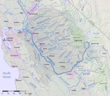
San Francisco Bay is a large tidal estuary in the U.S. state of California, and gives its name to the San Francisco Bay Area. It is dominated by the cities of San Francisco, San Jose, and Oakland.

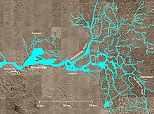
Suisun Bay is a shallow tidal estuary in Northern California. It lies at the confluence of the Sacramento River and San Joaquin River, forming the entrance to the Sacramento–San Joaquin River Delta, an inverted river delta. To the west, Suisun Bay is drained by the Carquinez Strait, which connects to San Pablo Bay, a northern extension of San Francisco Bay. Grizzly Bay forms a northern extension of Suisun Bay. Suisun Bay is between Contra Costa County to the south and Solano County to the north.

The Carquinez Strait is a narrow tidal strait located in the Bay Area of Northern California, United States. It is part of the tidal estuary of the Sacramento and the San Joaquin rivers as they drain into the San Francisco Bay. The strait is eight miles (13 km) long and connects Suisun Bay, which receives the waters of the combined rivers, with San Pablo Bay, a northern extension of the San Francisco Bay.

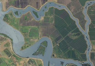
The Sacramento–San Joaquin River Delta, or California Delta, is an expansive inland river delta and estuary in Northern California. The Delta is formed at the western edge of the Central Valley by the confluence of the Sacramento and San Joaquin rivers and lies just east of where the rivers enter Suisun Bay, which flows into San Francisco Bay, then the Pacific Ocean via San Pablo Bay. The Delta is recognized for protection by the California Bays and Estuaries Policy. Sacramento–San Joaquin Delta was designated a National Heritage Area on March 12, 2019. The city of Stockton is located on the San Joaquin River at the eastern edge of the delta. The total area of the Delta, including both land and water, is about 1,100 square miles (2,800 km2). Its population is around 500,000.
The Port of Stockton is a major deepwater port on the Stockton Ship Channel of the Pacific Ocean and an inland port located more than seventy nautical miles from the ocean, in Stockton, California on the Stockton Channel and San Joaquin River-Stockton Deepwater Shipping Channel. By land acreage, the Port of Stockton is the 2nd largest port in the State of California and sits on about 4,200 acres (17 km2), and occupies an island in the Sacramento–San Joaquin River Delta, and a portion of a neighborhood known as Boggs Tract. It is governed by a commission appointed by the City of Stockton and San Joaquin County. The Port of Stockton is a self-sustaining economic powerhouse in the Central Valley and in 2023, contributed over $78 million in state and local tax funds.

The Port of Sacramento, now known as the Port of West Sacramento, is an inland port in West Sacramento, California, in the Sacramento metropolitan area. It is 79 nautical miles (146 km) northeast of San Francisco, and is centered in the California Central Valley, one of the richest agricultural regions in the world.
Georgiana Slough, is a slough within Sacramento County, California. It is located in the Sacramento–San Joaquin River Delta, and links both the Sacramento River and the San Joaquin River above their confluence in the Delta near Pittsburg, at the head of Suisun Bay, through its connection with the Mokelumne River. The entrance to the slough on the Sacramento River is just below Walnut Grove, at 38°14′21″N121°30′59″W and runs between Tyler Island and Andrus Island to where it has its confluence with the Mokelumne River at 38°07′49″N121°34′40″W northwest of Bouldin Island just above that rivers confluence with the San Joaquin River.

Bouldin Island is an island in the Sacramento-San Joaquin River Delta, 20 kilometers (12 mi) northwest of Stockton on the Stockton Deepwater Shipping Channel. It is in San Joaquin County, and managed by Reclamation District 756. The island is owned by the Metropolitan Water District of Southern California.
Venice Island is an island in the Sacramento-San Joaquin River Delta, fifteen kilometres northwest of Stockton. It is in San Joaquin County, California, and managed by Reclamation District 2023.

Mandeville Island is an island in the Sacramento–San Joaquin Delta located about 15 miles (24 km) northwest of Stockton, in central California in the United States. The island covers about 5,500 acres (2,200 ha), and lies between the Old River to the west and Middle River to the east, both distributaries of the San Joaquin River-Stockton Deepwater Shipping Channel. The Connection Slough forms the island's southern end, and Sand Mound Slough borders the island to the north. The island lies directly to the east of Franks Tract State Recreation Area. It is in San Joaquin County, and managed by Reclamation District 2027.
Steamboats operated in California on San Francisco Bay and the Sacramento–San Joaquin River Delta, and Sacramento River as early as November 1847, when the Sitka built by William A. Leidesdorff briefly ran on San Francisco Bay and up the Sacramento River to New Helvetia. After the first discovery of gold in California the first shipping on the bays and up the rivers were by ocean going craft that were able to sail close to the wind and of a shallow enough draft to be able to sail up the river channels and sloughs, although they were often abandoned by their crews upon reaching their destination. Regular service up the rivers, was provided primarily by schooners and launches to Sacramento and Stockton, that would take a week or more to make the trip.

The Old River is a tidal distributary of the San Joaquin River that flows for about 40 miles (64 km) through the Sacramento–San Joaquin River Delta in Northern California. The Old River was once the main channel of the San Joaquin until navigation and flood control projects in the late 19th and 20th century fixed the San Joaquin to its present course past Stockton. It diverges from the San Joaquin near Tracy, about 38 miles (61 km) upstream from Antioch, and first runs west towards Mountain House, then north to rejoin the San Joaquin 13 miles (21 km) above Antioch. The river is lined with levees that prevent flooding of the adjacent Delta islands, many of which lie below sea level. The Middle River runs east of and roughly parallel to Old River. False River diverges from Old River about a mile (1.6 km) above the Old River's mouth and runs westward to join the San Joaquin at a point closer to Antioch. Part of the Old River forms the boundary between San Joaquin County on the east and Contra Costa County to the west.

Winter Island is a 453-acre (183 ha) island in Suisun Bay, in the western Sacramento-San Joaquin River Delta. It is north of Pittsburg, separated from Browns Island to the west by a slough. It was private property, and contained one house. It is used as a duck hunting area, a wetland, and a dredging disposal area. In 2016 Winter Island was purchased by the California Department of Water Resources in order to restore the island as a tidal marsh. Winter Island is part of Contra Costa County, and managed by Reclamation District 2122. It is shown, labeled "Ruckels Island", on an 1850 survey map of the San Francisco Bay area made by Cadwalader Ringgold and an 1854 map of the area by Henry Lange.

.

Hickinbotham Brothers Shipbuilders was a shipbuilding company in Stockton, California on the Stockton Channel. To support the World War II demand for ships Hickinbotham Brothers built: Type V ship Tugboats, Tank Landing Barge, balloon barges and Coastal Freighter. Hickinbotham Brothers also called Hickinbotham Brothers Construction Division was opened in 1852 and is still a working shipyard. Hickinbotham Brothers started by building: horse carriages, horse wagons, threshers and Combine harvester. In 1942 Ronald Guntert and L. R. Zimmerman ran the company as a partnership on the Banner Island waterfront. After World War II, Guntert and Zimmerman purchased Hickinbotham out and renamed the company Guntert & Zimmerman Construction. In 1984 the company moved to Ripon, California on the Stanislaus River, as the business continues. The Banner Island waterfront yard was on the deepwater port on the Stockton Ship Channel of the Pacific Ocean and an inland port located more than seventy nautical miles from the ocean, on the Stockton Channel and San Joaquin River-Stockton Deepwater Shipping Channel (before it joins the Sacramento River to empty into Suisun Bay. Notable ship: USNS Shearwater.

Headreach Island is a small island in the Sacramento–San Joaquin River Delta, in northern California. A naturally-formed island existing in a complex with Tule Island to the southeast and Fern Island to the northwest, it was used for farming as late as the 1920s. While several proposals for real estate development on the island were made in the late 20th century, it now consists mostly of marsh and submerged land. Black rails live on the island.

Spud Island is a small island of the San Joaquin River, located in the Sacramento–San Joaquin River Delta in northern California. It was once used to farm onions; while it is no longer used for agriculture, it remains inhabited. In the late 20th century it was the site of a county park, which offered camping, fishing and swimming amenities free of charge.

Tinsley Island is a small island in the Sacramento–San Joaquin River Delta, in San Joaquin County, California, next to the Stockton Deepwater Shipping Channel. It was created in the 1930s, when dredging to improve the navigability of the San Joaquin River cut it off from Roberts Island. Since 1958, it has been owned by the St. Francis Yacht Club. In 1960, the club transported a lighthouse from San Francisco Bay to serve as its clubhouse, and in the same year began an annual "Stag Cruise"; as of 2024, the club still owns the island and maintains a clubhouse there.

Hog Island is an island in the San Joaquin River, and is one of many islands which constitute the Sacramento–San Joaquin River Delta. It was used for agriculture in the early 20th century, but has now mostly become marsh or submerged land; it remains a spot for fishing, particularly channel and blue catfish.

Chain Island is an island in Suisun Bay, downstream of the Sacramento–San Joaquin River Delta in northern California, and the westernmost piece of land in Sacramento County. In the late 1800s, it was considered an "obstruction to navigation" on the Sacramento River. As it was built up significantly from hydraulic mining tailings upstream on the river, plans were made in the early 20th century to remove it and recoup costs by mining the debris. However, this never happened; it was sold by the California State Lands Commission to a private individual in 1959, who listed it for sale the next year. In April 2016, the deed for the island was transferred; as of December 2022, Sacramento County assesses its land value at $18,622.