South Fork American River

Last updated
South Fork American River
Gorilla Pond.jpg
Location
Country United States
State California
Physical characteristics
Source 
  location Sierra Nevada
  coordinates 38°48′38″N120°01′52″W / 38.81056°N 120.03111°W / 38.81056; -120.03111 [1]
Mouth  
  location
Folsom Lake
  coordinates
38°44′03″N121°06′15″W / 38.73417°N 121.10417°W / 38.73417; -121.10417 [1]
  elevation
466 ft (142 m)
Length87 mi (140 km) [2]
Basin size840 sq mi (2,200 km2) [3]
Discharge 
  average1,458 cu ft/s (41.3 m3/s) [4]
Basin features
Progression AmericanSacramento

The South Fork American River is a major tributary of the American River in El Dorado County, California, [1] draining a watershed on the western slope of the Sierra Nevada east of Sacramento. The river begins in pristine Desolation Wilderness and flows through the Sierra Nevada foothills. The river at Coloma was the site of James Marshall's discovery of gold at Sutter's Mill on January 24, 1848, which started the California Gold Rush. [5] The South Fork of the American is "the most popular recreation stream in the West" for whitewater rafting in North America, [6] e.g., 80,000 visitors in 2011. [7] Professional whitewater rafting companies have been offering commercial rafting trips on the South Fork American River since 1978.

Contents

Geography

The river begins at Nebelhorn near Johnson Pass about 10 mi (16 km) south of Lake Tahoe. From there it flows west for 87 mi (140 km), [2] past the towns of Kyburz, Pollock Pines and Coloma, before emptying into Folsom Lake, the reservoir formed by the Folsom Dam. The North Fork American River also flows into the lake, and the combined rivers form the American River proper, which flows from the dam southwest to a confluence with the Sacramento River. [8]

The South Fork drains an area of 840 sq mi (2,200 km2), [3] or about a third of the 2,150 sq mi (5,600 km2) American River watershed. Major tributaries include Silver Creek, Rock Creek, Weber Creek, and Silver Fork American River. Most of the watershed consists of high, forested mountains and steep-sided valleys that receive up to 40 in (1,000 mm) of annual precipitation, except for the westernmost section which consists of drier foothill country. The river also contributes about a third of the total outflow of the American River system. [3]

Map of the American River system. The South Fork flows due west from El Dorado County into Folsom Lake near the bottom of the watershed. Americanrivermap.png
Map of the American River system. The South Fork flows due west from El Dorado County into Folsom Lake near the bottom of the watershed.

Discharge

According to a U.S. Geological Survey stream gage at Lotus, about 5 mi (8.0 km) above Folsom Lake, the average discharge was 1,458 cu ft/s (41.3 m3/s) from 1951 to 1995. [4] The highest recorded flow was 90,000 cu ft/s (2,500 m3/s) on January 1, 1997 (see New Year's Flood), [9] and the lowest monthly mean was 86.8 cu ft/s (2.46 m3/s) in July 1977. [4]

Recreation

Rafting and kayaking

A raft and an inflatable kayak maneuver through Troublemaker rapid in Coloma California Troublemaker Rapid.jpg
A raft and an inflatable kayak maneuver through Troublemaker rapid in Coloma California

The South Fork of the American has approximately eight sections of boatable whitewater ranging from class II to class V. [10] The most commonly run section of river is the class III stretch between Chili Bar Dam and Folsom Lake.

This 20 mile section is best divided into two days of boating, from Chili Bar to Coloma (Chili Bar) and Coloma to Folsom Lake (The Gorge). Established boating and river rescue skills are required to run this section of river.

California poppies California Poppies American River.jpg
California poppies

Hiking, mountain biking and horse riding

There is BLM[ clarification needed ] land located off Highway 49 on the way to Auburn from Coloma with great hiking, biking and equestrian trails.

These BLM managed areas are part of a 20-year joint effort with the American River Conservancy to protect the habitat and beauty of the South Fork of the American River. The trail represents the foothills’ various ecosystems including grasslands, oak woodland, chaparral and riparian habitats. [11]

Dams

There are two dams on the South Fork proper: Slab Creek Dam, which forms Slab Creek Reservoir near Camino, and Chili Bar Dam, located north of Placerville. Both are run-of-the-river dams serving mainly for hydroelectricity production. Other major dams in the South Fork basin include ones at Union Valley Reservoir and Ice House Reservoir on the Silver Creek drainage. Most of the dams and reservoirs in the basin are operated by the Sacramento Municipal Utility District (SMUD) as part of the 688 megawatt Upper American River Project [12] and Pacific Gas and Electric as part of the Chili Bar Project.

See also

Related Research Articles

<span class="mw-page-title-main">Tuolumne River</span> River from Yosemite to the San Joaquin Valley, California

The Tuolumne River flows for 149 miles (240 km) through Central California, from the high Sierra Nevada to join the San Joaquin River in the Central Valley. Originating at over 8,000 feet (2,400 m) above sea level in Yosemite National Park, the Tuolumne drains a rugged watershed of 1,958 square miles (5,070 km2), carving a series of canyons through the western slope of the Sierra. While the upper Tuolumne is a fast-flowing mountain stream, the lower river crosses a broad, fertile and extensively cultivated alluvial plain. Like most other central California rivers, the Tuolumne is dammed multiple times for irrigation and the generation of hydroelectricity.

<span class="mw-page-title-main">McKenzie River (Oregon)</span> Mckenzie Blue River

The McKenzie River is a 90-mile (145 km) tributary of the Willamette River in western Oregon in the United States. It drains part of the Cascade Range east of Eugene and flows westward into the southernmost end of the Willamette Valley. It is named for Donald McKenzie, a Scottish Canadian fur trader who explored parts of the Pacific Northwest for the Pacific Fur Company in the early 19th century. As of the 21st century, six large dams have been built on the McKenzie and its tributaries.

<span class="mw-page-title-main">Pit River</span> River in California, United States

The Pit River is a major river draining from northeastern California into the state's Central Valley. The Pit, the Klamath and the Columbia are the only three rivers in the U.S. that cross the Cascade Range.

<span class="mw-page-title-main">Feather River</span> River in California, United States

The Feather River is the principal tributary of the Sacramento River, in the Sacramento Valley of Northern California. The river's main stem is about 73 miles (117 km) long. Its length to its most distant headwater tributary is just over 210 miles (340 km). The main stem Feather River begins in Lake Oroville, where its four long tributary forks join—the South Fork, Middle Fork, North Fork, and West Branch Feather Rivers. These and other tributaries drain part of the northern Sierra Nevada, and the extreme southern Cascades, as well as a small portion of the Sacramento Valley. The total drainage basin is about 6,200 square miles (16,000 km2), with approximately 3,604 square miles (9,330 km2) above Lake Oroville.

<span class="mw-page-title-main">Trinity River (California)</span> River in northern California

The Trinity River is a major river in northwestern California in the United States and is the principal tributary of the Klamath River. The Trinity flows for 165 miles (266 km) through the Klamath Mountains and Coast Ranges, with a watershed area of nearly 3,000 square miles (7,800 km2) in Trinity and Humboldt Counties. Designated a National Wild and Scenic River, along most of its course the Trinity flows swiftly through tight canyons and mountain meadows.

<span class="mw-page-title-main">Cosumnes River</span> River in northern California, United States

The Cosumnes River is a river in northern California in the United States. It rises on the western slope of the Sierra Nevada and flows approximately 52.5 miles (84.5 km) into the Central Valley, emptying into the Mokelumne River in the Sacramento-San Joaquin Delta.

<span class="mw-page-title-main">Mokelumne River</span> River in northern California

The Mokelumne River is a 95-mile (153 km)-long river in northern California in the United States. The river flows west from a rugged portion of the central Sierra Nevada into the Central Valley and ultimately the Sacramento–San Joaquin River Delta, where it empties into the San Joaquin River-Stockton Deepwater Shipping Channel. Together with its main tributary, the Cosumnes River, the Mokelumne drains 2,143 square miles (5,550 km2) in parts of five California counties. Measured to its farthest source at the head of the North Fork, the river stretches for 157 miles (253 km).

The Sacramento Municipal Utility District (SMUD) is a community-owned electric utility serving Sacramento County and parts of Placer County. It is one of the ten largest publicly owned utilities in the United States, generating the bulk of its power through natural gas and large hydroelectric generation plants. SMUD's green power (renewable) energy output was estimated as 33.8% in 2020.

<span class="mw-page-title-main">Yuba River</span> Waterway in Northern California

The Yuba River is a tributary of the Feather River in the Sierra Nevada and eastern Sacramento Valley, in the U.S. state of California. The main stem of the river is about 40 miles (64 km) long, and its headwaters are split into three major forks. The Yuba River proper is formed at the North Yuba and Middle Yuba rivers' confluence, with the South Yuba joining a short distance downstream. Measured to the head of the North Yuba River, the Yuba River is just over 100 miles (160 km) long.

<span class="mw-page-title-main">Cache Creek (Sacramento River tributary)</span> Stream from Lake to Yolo Counties, CA

Cache Creek is an 87-mile-long (140 km) stream in Lake, Colusa and Yolo counties, California.

<span class="mw-page-title-main">Cherry Creek (Tuolumne River tributary)</span> River in California, United States

Cherry Creek is a large, swift-flowing stream in the Sierra Nevada mountain range, and is the largest tributary of the Tuolumne River. The creek is 40 miles (64 km) long measured to its farthest headwaters; the main stem itself is 26 miles (42 km) long, draining a watershed of 234 square miles (610 km2) in the Stanislaus National Forest. Part of the drainage also extends into the northwest corner of Yosemite National Park.

<span class="mw-page-title-main">Loon Lake (California)</span> Reservoir in El Dorado County, California

Loon Lake is a reservoir in the Eldorado National Forest of El Dorado County, California, United States. The 76,200 acre⋅ft (94,000,000 m3) lake is formed by Loon Lake Dam, completed in 1963 as part of the Upper American River Project by Sacramento Municipal Utility District to conserve spring snow melt runoff for use during the summer and autumn for hydroelectric power production. Loon Lake Dam impounds water at the headwaters of Gerle Creek which, prior to the dam, flowed intermittently through (natural) Loon and Pleasant Lakes. But most of the water now stored in Loon Lake arrives from Buck Island Reservoir in the adjacent Rubicon River watershed by way of the Buck-Loon Tunnel. Nearby is Loon Lake Chalet, a popular winter recreation destination. In summer, a boat ramp for water sports and camping are available, but the area is less popular than nearby Union Valley Reservoir and Rubicon Trail.

<span class="mw-page-title-main">North Fork Feather River</span> River in California, United States

The North Fork Feather River is a watercourse of the northern Sierra Nevada and southern Cascades in the U.S. state of California. It flows generally southwards from its headwaters near Lassen Peak to Lake Oroville, a reservoir formed by Oroville Dam in the foothills of the Sierra, where it runs into the Feather River. The river drains about 2,100 square miles (5,400 km2) of the western slope of the Sierras. By discharge, it is the largest tributary of the Feather.

<span class="mw-page-title-main">Bear River (Feather River tributary)</span> River in California, United States

The Bear River is a tributary of the Feather River in the Sierra Nevada, winding through four California counties: Yuba, Sutter, Placer, and Nevada. About 73 miles (117 km) long, the river flows generally southwest through the Sierra then west through the Central Valley, draining a narrow, rugged watershed of 295 square miles (760 km2).

<span class="mw-page-title-main">American River</span> River in California, United States

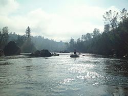
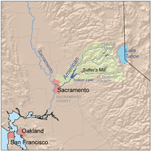
The American River is a 30-mile (50 km)-long river in California that runs from the Sierra Nevada mountain range to its confluence with the Sacramento River in downtown Sacramento. Via the Sacramento River, it is part of the San Francisco Bay watershed. This river is fed by the melting snowpack of the Sierra Nevada and its many headwaters and tributaries, including the North Fork American River, the Middle Fork American River, and the South Fork American River.

<span class="mw-page-title-main">Stony Creek (Sacramento River tributary)</span> River in California, United States

Stony Creek is a 73.5-mile (118.3 km)-long tributary of the Sacramento River in Northern California. It drains a watershed of more than 700 square miles (1,800 km2) on the west side of the Sacramento Valley in Glenn, Colusa, Lake and Tehama Counties.

<span class="mw-page-title-main">North Fork American River</span> Tributary of the river in Northern California

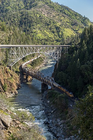
The North Fork American River is the longest branch of the American River in Northern California. It is 88 miles (142 km) long from its source at the crest of the Sierra Nevada, near Lake Tahoe, to its mouth at Folsom Lake northeast of Sacramento. Prior to the construction of Folsom Dam the river was about 9 miles (14 km) longer making for a total length of 97 miles (156 km).

<span class="mw-page-title-main">Middle Fork American River</span> Tributary of the river in Northern California

The Middle Fork American River is one of three forks that form the American River in Northern California. It drains a large watershed in the high Sierra Nevada west of Lake Tahoe and northeast of Sacramento in Placer and El Dorado Counties, between the watersheds of the North Fork American River and South Fork American River. The Middle Fork joins with the North Fork near Auburn and they continue downstream to Folsom Lake as the North Fork, even though the Middle Fork carries a larger volume of water.

Slab Creek Dam is a dam in the American River watershed of the central Sierra Nevada, within El Dorado County, California.

<span class="mw-page-title-main">Upper American River Project</span>

The Upper American River Project (UARP) is a hydroelectric system operated by the Sacramento Municipal Utility District (SMUD) of Sacramento, California in the United States.

References

  1. 1 2 3 "South Fork American River". Geographic Names Information System . United States Geological Survey, United States Department of the Interior. 1981-01-19. Retrieved 2013-04-14.
  2. 1 2 U.S. Geological Survey. National Hydrography Dataset high-resolution flowline data. The National Map, accessed 2011-03-10
  3. 1 2 3 Egbert, Mark et al. (May 2004). "South Fork American River Watershed Stewardship Strategy" (PDF). El Dorado County and Georgetown Divide Resource Conservation Districts. Retrieved 2013-04-14.{{cite web}}: CS1 maint: uses authors parameter (link)
  4. 1 2 3 "USGS Gauge #11445500 on the South Fork American River near Lotus, CA: Monthly Streamflow". National Water Information System. U.S. Geological Survey. 1951–1995. Retrieved 2013-04-14.
  5. "South Fork of the American River". The American River: California's favorite whitewater river. Retrieved 2013-04-14.
  6. McHugh, Paul (April 11, 2011). "California whitewater rafting: Season's on for 2014 (drought or not)". San Jose Mercury. Retrieved December 2, 2018.
  7. Branan, Brad (April 22, 2017). "Record snowpack makes for wild whitewater rafting on American River". Sacramento Bee. Retrieved December 2, 2018.
  8. USGS Topo Maps for United States (Map). Cartography by United States Geological Survey. ACME Mapper. Retrieved 2013-04-14.
  9. "USGS Gage #11445500 on the South Fork American River near Lotus, CA: Peak Streamflow". National Water Information System. U.S. Geological Survey. 1951–1997. Retrieved 2013-04-14.
  10. "Home". americanwhitewater.org.
  11. "Home".
  12. "SMUD projects awarded grants totaling nearly $6.5 million to advance hydropower technologies". Sacramento Municipal Utility District. 2012-09-12. Retrieved 2013-04-14.