List of rivers of New York

Last updated

The Raquette River, in Colton, New York Raquette (1).jpg
The Raquette River, in Colton, New York

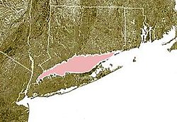
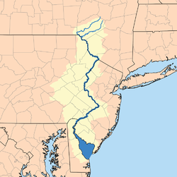
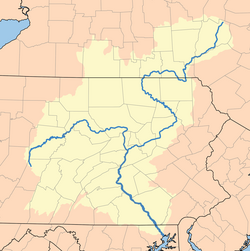
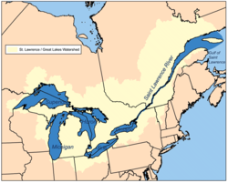
Rivers in the U.S. state of New York include:

By drainage basin

This list is arranged by drainage basin, with respective tributaries indented by order of confluence with their main stem, from mouth to source.

Contents

Long Island Sound (northern side)

Long Island Sound is shown highlighted in pink between Connecticut (to the north) and Long Island (to the south). Wpdms ev26188 long island sound.jpg
Long Island Sound is shown highlighted in pink between Connecticut (to the north) and Long Island (to the south).

Long Island

Long Island Sound
Block Island Sound
Atlantic Ocean

New York Harbor

New York City waterways: 1. Hudson River, 2. East River, 3. Long Island Sound, 4. Newark Bay, 5. Upper New York Bay, 6. Lower New York Bay, 7. Jamaica Bay, 8. Atlantic Ocean Waterways New York City Map Julius Schorzman.png
New York City waterways: 1. Hudson River, 2. East River, 3. Long Island Sound, 4. Newark Bay, 5. Upper New York Bay, 6. Lower New York Bay, 7. Jamaica Bay, 8. Atlantic Ocean

Hudson River Basin

Hudson drainage basin Hudsonmap.png
Hudson drainage basin

Delaware River Basin

Delaware drainage basin Delawarerivermap.png
Delaware drainage basin

Susquehanna River Basin

Susquehanna drainage basin Susquehanna River watershed.png
Susquehanna drainage basin

St. Lawrence River Basin

Lake Champlain

Lake Champlain drainage basin Champlainmap.svg
Lake Champlain drainage basin
St. Lawrence/Great Lakes drainage basin Grlakes lawrence map.png
St. Lawrence/Great Lakes drainage basin

St. Lawrence River

Lake Ontario

Black drainage basin Blacknyrivermap.png
Black drainage basin
Oswego River drainage basin Oswegorivermap.png
Oswego River drainage basin
Butternut Creek, Onondaga County Butternut-Creek-Jamesville-NY-2014.jpg
Butternut Creek, Onondaga County
Genesee drainage basin Genesee map large.jpg
Genesee drainage basin

Lake Erie

Mississippi River Basin

Alphabetically

See also

Related Research Articles

<span class="mw-page-title-main">Beaver Kill</span> River in New York, United States

The Beaver Kill, sometimes written as the Beaverkill or Beaverkill River, is a tributary of the East Branch Delaware River, a main tributary of the Delaware River, approximately 44 miles (71 km) long, in the U.S. state of New York. The kill drains a 300-square-mile (780 km2) area of the Catskill Mountains and has long been celebrated as one of the most famous trout streams in the United States. Its preservation helped establish many of the basic conservation principles of rivers in the United States.

<span class="mw-page-title-main">Oswegatchie River</span> River in northern New York state, US

The Oswegatchie River is a 137-mile-long (220 km) river in northern New York that flows from the Adirondack Mountains north to the Saint Lawrence River. The Oswegatchie River begins at Partlow Lake in Hamilton County, New York. The river continues through Cranberry Lake which was 'doubled in size' through construction of a dam in the late 1860s. The river continues from the dam to Gouverneur, to near Talcville in St. Lawrence County, where it joins the West Branch. Much of it is within Adirondack State Park. The city of Ogdensburg developed at the mouth of the river at its confluence with the St. Lawrence.

<span class="mw-page-title-main">Rondout Creek</span> River in New York, United States

Rondout Creek is a 63.3-mile-long (101.9 km) tributary of the Hudson River in Ulster and Sullivan counties, New York, United States. It rises on Rocky Mountain in the eastern Catskills, flows south into Rondout Reservoir, part of New York City's water supply network, then into the valley between the Catskills and the Shawangunk Ridge, where it goes over High Falls and finally out to the Hudson at Kingston, receiving along the way the Wallkill River.

<span class="mw-page-title-main">Esopus Creek</span> Tributary of the Hudson River in the Catskill region of New York state

Esopus Creek is a 65.4-mile-long (105.3 km) tributary of the Hudson River that drains the east-central Catskill Mountains in the U.S. state of New York. From its source at Winnisook Lake on the slopes of Slide Mountain, the Catskills' highest peak, it flows across Ulster County to the Hudson at Saugerties. Many tributaries extend its watershed into neighboring Greene County and a small portion of Delaware County. Midway along its length, it is impounded at Olive Bridge to create Ashokan Reservoir, the first of several built in the Catskills as part of New York City's water supply system. Its own flow is supplemented 13 miles (21 km) above the reservoir by the Shandaken Tunnel, which carries water from the city's Schoharie Reservoir into the creek.

<span class="mw-page-title-main">Five Ponds Wilderness Area</span>

The Five Ponds Wilderness Area, an Adirondack Park unit of New York's Forest Preserve, is located in the towns of Fine and Clifton in St. Lawrence County, the town of Webb in Herkimer County and the town of Long Lake in Hamilton County. It includes 1,064 acres (4.3 km2) of private inholdings, 99 bodies of water covering 1,964 acres (7.9 km2), 57.9 miles (93.2 km) of trails, and 14 lean-tos.

<span class="mw-page-title-main">Willowemoc Creek</span> River in New York, United States

Willowemoc Creek is a tributary of Beaver Kill. It is a popular trout fishing stream near the Catskill Park in Sullivan County, New York.

The Belgrade Lakes are a chain of lakes around Belgrade, Maine. The flow sequence is from East Pond to North Pond to Great Pond to Long Pond to Messalonskee Lake and thence via Messalonskee Stream to the Kennebec River at Waterville. The lakes have long been an important resort area for fishing, boating, and swimming; and shoreline development includes residences for individuals employed in the cities of Waterville and Augusta.

References