List of canals in the United States

Last updated

USA canals circa 1825 Canals USA 1825.png
USA canals circa 1825

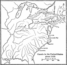
The following is a list of canals in the United States :

Contents

Transportation canals in operation

This list includes active canals and artificial waterways that are maintained for use by boats. Although some abandoned canals and drainage canals have stretches that can be paddled in a small craft, such as a canoe, they are not included in this list.

NamePlaceStateNavigable lengthNotes
Albemarle and Chesapeake Canal Chesapeake VA 8.5 mi (13.7 km)Two canals 30 miles (48 km) apart in two states
Currituck County NC 5.5 mi (8.9 km)
Alligator–Pungo Canal Hyde County, Tyrell County NC 22 mi (35 km)
Assawoman Canal Sussex County DE 4 mi (6.4 km)Part of the Intracoastal Waterway
Atlantic Intracoastal Waterway East Coast Part of the Intracoastal Waterway
Augusta Canal Augusta; Columbia County GA 6.8 mi (10.9 km)Not navigable to other waterways
Bricktown Canal Bricktown OK 1 mi (1.6 km)Has water taxi service. Not navigable to other waterways
Barkley Canal Lyon County KY 1.25 mi (2.01 km)
Cal-Sag Channel Cook County IL 16 mi (26 km)Part of the Illinois Waterway
Calcasieu Ship Channel Calcasieu Parish, Cameron Parish LA 36.5 mi (58.7 km)
Canaveral Barge Canal Merritt Island FL 6 mi (9.7 km)
Cape Cod Canal Barnstable County MA 7 mi (11 km)Part of the Intracoastal Waterway
Cape May Canal Cape May County NJ 3.3 mi (5.3 km)Part of the Intracoastal Waterway
Cayuga–Seneca Canal Seneca County NY 20 mi (32 km)
Chain of Rocks Canal Madison County IL 9 mi (14 km)The most downstream lock on the Upper Mississippi River
Champlain Canal Upstate New York NY 60 mi (97 km)
Chesapeake & Delaware Canal Cecil County MD 14 mi (23 km)Part of the Intracoastal Waterway
New Castle County DE
Chicago Sanitary and Ship Canal Cook County, Will County IL 28 mi (45 km)Part of the Illinois Waterway
Clam Lake Canal Cadillac MI 0.33 mi (0.53 km)
Corpus Christi Ship Channel Corpus Christi TX
Cumberland and Oxford Canal Naples ME 0.04 mi (0.064 km)Only the Songo Lock is still in use
Delcambre Canal Iberia Parish LA 12 mi (19 km)
Dismal Swamp Canal Chesapeake VA 22 mi (35 km)Part of the Intracoastal Waterway
Camden County NC
Duluth Ship Canal Duluth MN 0.33 mi (0.53 km)
Erie Canal Upstate New York NY 363 mi (584 km)
Galveston and Brazos Canal Brazoria County TX
Gowanus Canal Brooklyn NY 1.8 mi (2.9 km)
Great Lakes Waterway Great Lakes region Has many branches. Reaches into Canada
Gulf Intracoastal Waterway Gulf Coast 1,050 mi (1,690 km)Part of the Intracoastal Waterway
Harlem River Ship Canal New York NY 8 mi (13 km)Now indistinguishable from the Harlem River
Haulover Canal Brevard County FL 1.25 mi (2.01 km)Part of the Intracoastal Waterway
Houston Ship Channel Houston TX 50 mi (80 km)
Illinois Waterway Northern and Central Illinois IL 336 mi (541 km)
Indiana Harbor and Ship Canal East Chicago IN 6.75 mi (10.86 km)Has two branches
Industrial Canal (Inner Harbor Navigation Canal) New Orleans LA 5.5 mi (8.9 km)
Intracoastal Waterway 3,000 mi (4,800 km)Consists of many canals and natural waterbodies
Keweenaw Waterway Houghton County MI 24.5 mi (39.4 km)
Lake Washington Ship Canal Seattle WA 8 mi (13 km)
Lauritzen Canal Richmond CA 0.32 mi (0.51 km)
Lechmere Canal East Cambridge MA 0.2 mi (0.32 km)
Lewes and Rehoboth Canal Sussex County DE 9 mi (14 km)Part of the Intracoastal Waterway
Louisville and Portland Canal Louisville KY 2 mi (3.2 km)
Matagorda Ship Channel Matagorda County TX 2 mi (3.2 km)
McClellan–Kerr Arkansas River Navigation System AR 445 mi (716 km)
Eastern Oklahoma OK
Ogden Slip Chicago IL 0.35 mi (0.56 km)
Okeechobee Waterway South Florida FL 154 mi (248 km)
Oswego Canal Oswego County NY 23.7 mi (38.1 km)
Point Pleasant Canal Point Pleasant NJ 2 mi (3.2 km)Part of the Intracoastal Waterway
Port Townsend Ship Canal Jefferson County WA 0.9 mi (1.4 km)
Portage Lake Canal Houghton County MI 2.5 mi (4.0 km)Part of Keweenaw Waterway
Sabine–Neches Waterway Southeast Texas TX 64 mi (103 km)
Calcasieu Parish LA
Sacramento Deep Water Ship Channel Solano County, Yolo County CA 43 mi (69 km)
Smith Canal Stockton CA 2.4 mi (3.9 km)
St. Clair Flats Canal Clay Township MI
St. Lawrence Seaway Jefferson County, St. Lawrence County NY 370 mi (600 km)Spans into Canada
St. Lucie Canal (C-44) Martin County FL 26 mi (42 km)Part of the Okeechobee Waterway
Stockton Channel Stockton CA 2.5 mi (4.0 km)
Stockton Deepwater Shipping Channel San Joaquin County, Contra Costa County CA 41 mi (66 km)
Shinnecock Canal Hampton Bays NY 0.9 mi (1.4 km)
St. Marys Falls Canal (Soo Locks) Sault Ste. Marie MI 2 mi (3.2 km)Part of the Great Lakes Waterway
Sturgeon Bay Ship Canal Door County WI 1.3 mi (2.1 km)
Tennessee–Tombigbee Waterway Northeast Mississippi MS 234 mi (377 km)
Southwest Alabama AL
Victoria Barge Canal Victoria County, Calhoun County TX 35 mi (56 km)
West Neebish Channel Chippewa County MI 6 mi (9.7 km)Part of the Great Lakes Waterway
Wiley-Dondero Canal St. Lawrence County NY 9.2 mi (14.8 km)Part of the St. Lawrence Seaway

The United States also built the Panama Canal on territory it controlled.

Abandoned transportation canals

NameStateOpenedClosedLengthNotes
Alexandria Canal VA 184318867 mi (11 km)
Bald Eagle and Spring Creek Navigation PA 18371865
Bank's Canal VA
Beardstown and Sangamon Canal IL
Beaver and Erie Canal PA 18441872136 mi (219 km)Part of the Pennsylvania Canal
Bellows Falls Canal VT 18021858
Black River Canal NY 1855192535 mi (56 km)
Blackstone Canal RI 1828184845 mi (72 km)
MA
Brunswick–Altamaha Canal GA 1854186012 mi (19 km)
Cascade Locks and Canal OR 18961938
WA
Celilo Canal OR 19151957
WA
Chemung Canal NY 18331878
Chenango Canal NY 1836187897 mi (156 km)
Chesapeake and Ohio Canal MD 18301924184.5 mi (296.9 km)
DC
Clinton–Kalamazoo Canal MI 184313 mi (21 km)Partially completed
Codorus Navigation PA 1832185011 mi (18 km)
Colbert Shoals Canal AL Flooded by Pickwick Lake
Columbia Canal SC 1824Now used for hydroelectic power
Conestoga Navigation PA 182618 mi (29 km)
Conewago Canal PA 17971 mi (1.6 km)
Cross Florida Barge Canal FL 30 mi (48 km)Partially completed
Culpeper Gold Mine Canal VA
Cumberland and Oxford Canal ME 1832187338 mi (61 km) Songo Lock remains open
Deep Run Canal VA
Delaware and Hudson Canal PA 18281917108 mi (174 km)
NY
Delaware and Raritan Canal NJ 1834193266 mi (106 km)
Delaware Canal PA 1832193160 mi (97 km)Part of the Pennsylvania Canal
Des Moines Rapids Canal IA
Enfield Falls Canal CT 18295.25 mi (8.45 km)
Farmington Canal (New Haven and Northampton Canal) CT 1828184756 mi (90 km)Continued into Massachusetts as the Hampshire and Hampden Canal
Ficklin's Canal VA
Fox–Wisconsin Waterway WI Partially restored
Franklin Line PA 1833183722 mi (35 km)Part of the Pennsylvania Canal
Fredericksburg Canal VA
Genesee Valley Canal NY 18401878124 mi (200 km)
Hampshire and Hampden Canal MA 184730 mi (48 km)Continued into Connecticut as the Farmington Canal
Hennepin Canal IL 190775.2 mi (121.0 km)
Hocking Canal OH 1841189056 mi (90 km)
Illinois and Michigan Canal IL 1848193396 mi (154 km)
Indiana Central Canal IN 8 mi (13 km)Partially completed
James River and Kanawha Canal VA Only Virginia portion completed
Junction Canal PA 1854187118 mi (29 km)
NY
Landsford Canal SC 18232 mi (3.2 km)
Lehigh Canal PA 1821194272 mi (116 km)A mule-drawn tourist barge operates at the National Canal Museum
Leiper Canal PA 182918523 mi (4.8 km)
Love Canal NY
Main Line of Public Works PA
Miami Canal FL
Miami and Erie Canal OH 1913274 mi (441 km)
Middlesex Canal MA 1803185127 mi (43 km)
Milan Canal OH 18391868
Mississippi River–Gulf Outlet Canal LA 1968200976 mi (122 km)
Morris Canal NJ 18291924107 mi (172 km)
Muscle Shoals Canal AL Drowned under Wilson Lake?
Ohio and Erie Canal OH 1827308 mi (496 km)
Patowmack Canal (Potomac Canal) MD 17951828Consists of the Little Falls Canal, Great Falls Canal, Seneca Falls Canal, Payne's Falls Canal, and House Falls Canal
VA
Pawtucket Canal MA 1796
Pennsylvania Canal PA
Pennsylvania and Ohio Canal PA 1840187782 mi (132 km)
OH
Portage Canal WI 187619512 mi (3.2 km)
Powell's Canal VA
Rapidan Dam Canal of the Rappahannock Navigation VA
Sandy and Beaver Canal PA 1848185273 mi (117 km)
OH
Santee Canal SC 1800186522 mi (35 km)
Savannah Ogeechee Canal GA
Schuylkill Navigation PA 18251931108 mi (174 km)
Schuylkill and Susquehanna Navigation Company PA
Delaware and Schuylkill Navigation Company PA
Skinker's Canal VA
Snake Castle Canal VA
South Hadley Canal MA 1795
Spring Valley Canal VA
Susquehanna Canal MD 180218409 mi (14 km)
Susquehanna and Tidewater Canal PA 1840189443 mi (69 km)
MD
Suwannee Canal GA
Taylor's Canal VA
Union Canal PA 1828188582 mi (132 km)
Wabash and Erie Canal OH 18431874460 mi (740 km)
IN
Walhonding Canal OH 1842189625 mi (40 km)
Warren County Canal OH 1840184820 mi (32 km)
Washington City Canal DC 1815
Wheatley's Canal VA
Whitewater Canal IN 183976 mi (122 km)
Wiconisco Canal PA 1845188912 mi (19 km)

Irrigation, industrial, and drainage canals

Arizona

California

Florida

Hawaii

Idaho

Illinois

Louisiana

Massachusetts

Michigan

Nebraska

New Jersey

Texas

Natural inlets called canals

Lynn Canal and Portland Canal in Alaska and Hood Canal in Washington are natural inlets that use the name canal.

Canals by state

These are man made canals in each state that have been given a name and may consist of a narrow irrigation or drainage ditch to a large ship, municipal water and/or irrigation canal. States with extensive agricultural acreage may have many hundred to thousands of canals. USGS Topographical map numbers and latitudes and longitudes of each canal, usable as inputs into Google, Bing, etc. maps, are usually given.

Canals in each state
StateNumber
of canals
Ref.StateNumber
of canals
Ref.

Alabama 21 [1] Montana 858 [2]
Alaska 23 [3] Nebraska 209 [4]
Arizona 289 [5] Nevada 263 [6]
Arkansas 6 [7] New Hampshire 10 [8]
California 2,903 [9] New Jersey 41 [10]
Colorado 1,888 [11] New Mexico 69 [12]
Connecticut 8 [8] New York 116 [13]
Delaware 54 [14] North Carolina 151 [15]
Florida 245 [16] North Dakota 69 [17]
Georgia 25 [18] Ohio 22 [19]
Hawaii 125 [20] Oklahoma 9 [21]
Idaho 1,540 [22] Oregon 661 [23]
Illinois 278 [24] Pennsylvania 11 [25]
Indiana 2,239 [26] Rhode Island 3 [8]
Iowa 299 [27] South Carolina 33 [28]
Kansas 27 [29] South Dakota 91 [30]
Kentucky 62 [31] Tennessee 61 [32]
Louisiana 45 [33] Texas 299 [34]
Maine 7 [8] Utah 575 [35]
Maryland 44 [36] Vermont 1 [8]
Massachusetts 26 [8] Virginia 59 [37]
Michigan 1,668 [38] Washington 237 [39]
Minnesota 1,451 [40] West Virginia 2 [41]
Mississippi 185 [42] Wisconsin 89 [43]
Missouri 287 [44] Wyoming 1085 [45]

Total canals18,241

Related Research Articles

<span class="mw-page-title-main">Raritan River</span> Major river in the U.S. state of New Jersey

The Raritan River is a major river of New Jersey. Its watershed drains much of the mountainous area of the central part of the state, emptying into the Raritan Bay on the Atlantic Ocean.

<span class="mw-page-title-main">Delaware and Raritan Canal</span> United States historic place

The Delaware and Raritan Canal is a canal in central New Jersey, built in the 1830s, that connects the Delaware River to the Raritan River. It was an efficient and reliable means of transportation of freight between Philadelphia and New York City, transporting anthracite coal from eastern Pennsylvania during much of the 19th and early 20th centuries. The canal allowed shippers to cut many miles off the existing route from the Pennsylvania Coal Region down the Delaware, around Cape May, and up the occasionally treacherous Atlantic Ocean coast to New York City.

<span class="mw-page-title-main">Historical regions of the United States</span>

The territory of the United States and its overseas possessions has evolved over time, from the colonial era to the present day. It includes formally organized territories, proposed and failed states, unrecognized breakaway states, international and interstate purchases, cessions, and land grants, and historical military departments and administrative districts. The last section lists informal regions from American vernacular geography known by popular nicknames and linked by geographical, cultural, or economic similarities, some of which are still in use today.

<span class="mw-page-title-main">Titusville, New Jersey</span> Populated place in Mercer County, New Jersey, US

Titusville is an unincorporated community and census-designated place (CDP) located within Hopewell Township in Mercer County, in the U.S. state of New Jersey. The area includes a post office with its own ZIP Code (08560), several restaurants, gas stations, a firehouse, and a small cluster of homes. The Washington Crossing State Park, dedicated to George Washington's crossing of the Delaware River in 1776, is adjacent to the community.

<span class="mw-page-title-main">Delaware and Hudson Canal</span> Former canal in New York and Pennsylvania, United States

The Delaware and Hudson Canal was the first venture of the Delaware and Hudson Canal Company, which would later build the Delaware and Hudson Railway. Between 1828 and 1899, the canal's barges carried anthracite coal from the mines of northeastern Pennsylvania to the Hudson River and thence to market in New York City.

<span class="mw-page-title-main">United States National Register of Historic Places listings</span> Register for landmarks in the United States

The National Register of Historic Places in the United States is a register including buildings, sites, structures, districts, and objects. The Register automatically includes all National Historic Landmarks as well as all historic areas administered by the U.S. National Park Service. Since its introduction in 1966, more than 90,000 separate listings have been added to the register.

<span class="mw-page-title-main">Will S. Green</span>

William Semple Green was a California pioneer, a steamboat captain, mail carrier, surveyor, newspaper publisher, writer, legislator, United States Surveyor General for California, California State Treasurer, and irrigationist.

<span class="mw-page-title-main">Millstone River</span> Tributary of the Raritan River in New Jersey, United States

The Millstone River is a 38.6-mile-long (62.1 km) tributary of the Raritan River in central New Jersey in the United States.

<span class="mw-page-title-main">California State Water Project</span> Flood control, energy production, and water conveyance infrastructure

The California State Water Project, commonly known as the SWP, is a state water management project in the U.S. state of California under the supervision of the California Department of Water Resources. The SWP is one of the largest public water and power utilities in the world, providing drinking water for more than 27 million people and generating an average of 6,500 GWh of hydroelectricity annually. However, as it is the largest single consumer of power in the state itself, it has a net usage of 5,100 GWh.

<span class="mw-page-title-main">Bull's Island Recreation Area</span>

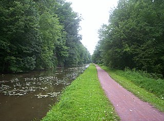
The 79-acre (0.32 km2) Bull's Island Recreation Area is on Bull's Island at Raven Rock along the Delaware River approximately 3 miles (4.8 km) north of Stockton, within Delaware Township in Hunterdon County, New Jersey, United States. The park is a part of the 3,578 acres (14.48 km2) Delaware and Raritan Canal State Park. It offers a boat launch, fishing, and a nature trail. Canoes, kayaks, tubes, and rafts can be rented three miles north in Point Pleasant. The surrounding park includes a portion of the D&R Canal Trail, a multi-use trail built on the former Belvidere-Delaware Railroad bed that runs along the island on a north-south route. The park is operated and maintained by the New Jersey Division of Parks and Forestry.

<span class="mw-page-title-main">Pennsylvania Canal (Delaware Division)</span> United States historic place

The Delaware Division of the Pennsylvania Canal, more commonly called the Delaware Canal, runs for 60 miles (97 km) parallel to the right bank of the Delaware River from the entry locks near the mouth of the Lehigh River and terminal end of the Lehigh Canal at Easton south to Bristol. At Easton, which today is the home of The National Canal Museum, the Delaware Canal also connected with the Morris Canal built to carry anthracite coal to energy-starved New Jersey industries.

<span class="mw-page-title-main">Delaware Canal State Park</span> State park in Bucks and Northampton counties, Pennsylvania

Delaware Canal State Park is a 830-acre (336 ha) Pennsylvania state park in Bucks and Northampton Counties in Pennsylvania. The main attraction of the park is the Delaware Canal which runs parallel to the Delaware River between Easton and Bristol.

<span class="mw-page-title-main">Interbasin transfer</span>

Interbasin transfer or transbasin diversion are terms used to describe man-made conveyance schemes which move water from one river basin where it is available, to another basin where water is less available or could be utilized better for human development. The purpose of such water resource engineering schemes can be to alleviate water shortages in the receiving basin, to generate electricity, or both. Rarely, as in the case of the Glory River which diverted water from the Tigris to Euphrates River in modern Iraq, interbasin transfers have been undertaken for political purposes. While ancient water supply examples exist, the first modern developments were undertaken in the 19th century in Australia, India and the United States, feeding large cities such as Denver and Los Angeles. Since the 20th century many more similar projects have followed in other countries, including Israel and China, and contributions to the Green Revolution in India and hydropower development in Canada.

<span class="mw-page-title-main">Stony Creek (Sacramento River tributary)</span> River in California, United States

Stony Creek is a 73.5-mile (118.3 km)-long tributary of the Sacramento River in Northern California. It drains a watershed of more than 700 square miles (1,800 km2) on the west side of the Sacramento Valley in Glenn, Colusa, Lake and Tehama Counties.

<span class="mw-page-title-main">Fieldville, New Jersey</span> Populated place in Middlesex County, New Jersey, US

Fieldville is a historical unincorporated community located within Piscataway Township in Middlesex County, in the U.S. state of New Jersey. The location is sometimes described as being on River Road south of Bound Brook. The community was named after John Field and his descendants who settled the area.

<span class="mw-page-title-main">Red Bluff Diversion Dam</span> Dam in Tehama County, California

Red Bluff Diversion Dam is a disused irrigation diversion dam on the Sacramento River in Tehama County, California, United States, southeast of the city of Red Bluff. Until 2013, the dam provided irrigation water for two canals that serve 150,000 acres (61,000 ha) of farmland on the west side of the Sacramento Valley. The dam and canals are part of the Sacramento Canals Unit of the Central Valley Project, operated by the U.S. Bureau of Reclamation. In 2013, the dam was decommissioned and the river allowed to flow freely through the site in order to protect migrating fish. A pumping plant constructed a short distance upstream now supplies water to the canal system.

References

  1. "Alabama canals". HomeTownLocator, Inc. Retrieved April 14, 2012.
  2. "Montana canals". HomeTownLocator, Inc. Retrieved April 14, 2012.
  3. "Alaska canals". HomeTownLocator, Inc. Retrieved April 14, 2012.
  4. "Nebraska canals". HomeTownLocator, Inc. Retrieved April 14, 2012.
  5. "Arizona canals". HomeTownLocator, Inc. Retrieved April 14, 2012.
  6. "Nevada canals". HomeTownLocator, Inc. Retrieved April 14, 2012.
  7. "Arkansas canals". HomeTownLocator, Inc. Retrieved April 14, 2012.
  8. 1 2 3 4 5 6 "Canals in New England". NewEnglandTowns.org. Retrieved April 14, 2012.
  9. "California canals". HomeTownLocator, Inc. Retrieved April 14, 2012.
  10. "New Jersey canals". HomeTownLocator, Inc. Retrieved April 14, 2012.
  11. "Colorado canals". HomeTownLocator, Inc. Retrieved April 14, 2012.
  12. "New Mexico canals". HomeTownLocator, Inc. Retrieved April 14, 2012.
  13. "New York canals". HomeTownLocator, Inc. Retrieved April 14, 2012.
  14. "Delaware canals". HomeTownLocator, Inc. Retrieved April 14, 2012.
  15. "North Carolina canals". HomeTownLocator, Inc. Retrieved April 14, 2012.
  16. "Florida canals". HomeTownLocator, Inc. Retrieved April 14, 2012.
  17. "North Dakota canals". HomeTownLocator, Inc. Retrieved April 14, 2012.
  18. "Georgia canals". HomeTownLocator, Inc. Retrieved April 14, 2012.
  19. "Ohio canals". HomeTownLocator, Inc. Retrieved April 14, 2012.
  20. "Hawaii canals". HomeTownLocator, Inc. Retrieved April 14, 2012.
  21. "Oklahoma canals". HomeTownLocator, Inc. Retrieved April 14, 2012.
  22. "Idaho canals". HomeTownLocator, Inc. Retrieved April 14, 2012.
  23. "Oregon canals". HomeTownLocator, Inc. Retrieved March 24, 2014.
  24. "Illinois canals". HomeTownLocator, Inc. Retrieved April 14, 2012.
  25. "Pennsylvania canals". HomeTownLocator, Inc. Retrieved April 14, 2012.
  26. "Indiana canals". HomeTownLocator, Inc. Retrieved April 14, 2012.
  27. "Iowa canals". HomeTownLocator, Inc. Retrieved April 14, 2012.
  28. "South Carolina canals". HomeTownLocator, Inc. Retrieved April 14, 2012.
  29. "Kansas canals". HomeTownLocator, Inc. Retrieved April 14, 2012.
  30. "South Dakota canals". HomeTownLocator, Inc. Retrieved April 14, 2012.
  31. "Kentucky canals". HomeTownLocator, Inc. Retrieved April 14, 2012.
  32. "Tennessee canals". HomeTownLocator, Inc. Retrieved April 14, 2012.
  33. "Louisiana canals". HomeTownLocator, Inc. Retrieved April 14, 2012.
  34. "Texas canals". HomeTownLocator, Inc. Retrieved April 14, 2012.
  35. "Utah canals". HomeTownLocator, Inc. Retrieved April 14, 2012.
  36. "Maryland canals". HomeTownLocator, Inc. Retrieved April 14, 2012.
  37. "Virginia canals". HomeTownLocator, Inc. Retrieved April 14, 2012.
  38. "Michigan canals". HomeTownLocator, Inc. Retrieved April 14, 2012.
  39. "Washington canals". HomeTownLocator, Inc. Retrieved April 14, 2012.
  40. "Minnesota canals". HomeTownLocator, Inc. Retrieved April 14, 2012.
  41. "West Virginia canals". HomeTownLocator, Inc. Retrieved April 14, 2012.
  42. "Mississippi canals". HomeTownLocator, Inc. Retrieved April 14, 2012.
  43. "Wisconsin canals". HomeTownLocator, Inc. Retrieved April 14, 2012.
  44. "Missouri canals". HomeTownLocator, Inc. Retrieved April 14, 2012.
  45. "Wyoming canals". HomeTownLocator, Inc. Retrieved April 14, 2012.

See also