Harrison is a town in Cumberland County, Maine, United States. The population was 2,447 at the 2020 census. A historic resort area, Harrison straddles Long Lake and Crystal Lake. It is part of the Portland–South Portland–Biddeford, Maine metropolitan statistical area.

Naples is a town in Cumberland County, Maine, United States. It is part of the Portland–South Portland–Biddeford, Maine metropolitan statistical area. The population was 3,925 at the 2020 census, and it is home to part of Sebago Lake State Park. Naples is a resort area.
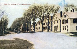
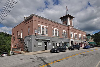
Standish is a town in Cumberland County, Maine, United States. The population was 10,244 at the 2020 census. It includes the villages of Standish Corner, Sebago Lake Village and Steep Falls, and the localities known as Richville, Elmwood, Standish Neck and Two Trails. Standish is part of the Portland-South Portland-Biddeford, Maine metropolitan statistical area.

Windham is a town in Cumberland County, Maine, United States. The population was 18,434 at the 2020 census. It includes the villages of South Windham and North Windham. It is part of the Portland–South Portland–Biddeford, Maine Metropolitan Statistical Area.

Long Lake is an eleven-mile (18 km) lake between the towns of Naples, Maine, Bridgton, Maine and Harrison, Maine. It is connected to Brandy Pond through the Chute River. Long Lake was created by receding glaciers, and has many coves and rocks.
Brandy Pond, also known as Bay of Naples Lake, is a small lake in Naples, Maine, United States, that is connected to Long Lake by the Chute River. Brandy Pond is connected to Sebago Lake by the Songo River, which runs through Sebago Lake State Park. To get to Sebago Lake through the Songo River, one must pass through Songo Lock, one of the last remaining hand-operated locks in the country.

Sebago Lake (Sih-Bay-Goh) is the deepest and second-largest lake in the U.S. state of Maine. The lake is 316 feet (96 m) deep at its deepest point, with a mean depth of 101 feet (31 m). It is possible that Sebago is the deepest lake wholly contained within the entire New England region, although some sources say that Vermont's Lake Willoughby is slightly deeper. Along with Lake Champlain, Sebago is one of the only lakes in the area that does not consistently freeze solid during the winter months, with total ice cover only occurring for a short period of time every few winters. Sebago covers about 45 square miles (117 km2) in surface area, has a length of 14 miles (23 km) and has a shoreline length of roughly 105 miles (169 km). The surface is around 270 feet (82 m) above sea level, so the deep bottom is below the present sea level. It is in Cumberland County, and bordered by the towns of Casco, Naples, Raymond, Sebago, Standish and Windham. The seasonally occupied town of Frye Island is on an island in the lake. Sebago Lake and the surrounding area is known for its erratic and sudden changes in weather during all seasons, likely due to its proximity to the Atlantic Ocean and to Mt. Washington, a very notorious extreme weather hotspot. The name comes from the Abenaki sobagoo, meaning "it is the sea" or "it resembles the sea".

U.S. Route 302 is an east–west spur of U.S. Route 2 in northern New England in the United States. It currently runs 171 miles (275 km) from Montpelier, Vermont, beginning at US 2, to Portland, Maine, at U.S. Route 1. It passes through the states of Vermont, New Hampshire and Maine.

The Bridgton and Saco River Railroad (B&SR) was a 2 ft narrow gauge railroad that operated in the vicinity of Bridgton and Harrison, Maine. It connected with the Portland and Ogdensburg Railroad from Portland, Maine, to St. Johnsbury, Vermont, near the town of Hiram on the Saco River.

The Presumpscot River is a 25.8-mile-long (41.5 km) river located in Cumberland County, Maine, United States. It is the main outlet of Sebago Lake. The river provided an early transportation corridor with reliable water power for industrial development of the city of Westbrook and the village of South Windham.

The Mountain Division is a railroad line that was once owned and operated by the Maine Central Railroad (MEC). It stretches from Portland, Maine on the Atlantic Ocean, through the Western Maine Mountains and White Mountains of New Hampshire, ending at St. Johnsbury, Vermont in the Northeast Kingdom. The line was abandoned in 1983 by MEC's successor, Guilford Transportation Industries (GTI). Guilford retained a stub between Portland and Westbrook. A section in New Hampshire remains in use by heritage railway Conway Scenic Railroad.

South Windham is a census-designated place (CDP) in the town of Windham in Cumberland County, Maine, United States. The population of the CDP was 1,374 at the 2010 census. Prior to 2010, South Windham was part of the Little Falls-South Windham census-designated place.
The Bear River is a 2.7-mile-long (4.3 km) tributary of Long Lake in the U.S. state of Maine. It originates at the outlet of Bear Pond in the town of Waterford in Oxford County, then flows southeast into the town of Bridgton in Cumberland County and finally the town of Harrison, where it reaches Long Lake. Via Long Lake, the Songo River, and Sebago Lake, the Bear River is part of the Presumpscot River watershed, flowing to Casco Bay on the Atlantic Ocean.
The Crooked River is a 58.0-mile-long (93.3 km) tributary of the Songo River in Maine. It is the longest of the tributaries of Sebago Lake, the outlet of which is the Presumpscot River, flowing to Casco Bay on the Atlantic Ocean.

The Pleasant River is a 13.1-mile-long (21.1 km) tributary of the Presumpscot River in the U.S. state of Maine.

The Songo River is a 3.1-mile-long (5.0 km) river in Maine. The river flows from Brandy Pond at the south end of Long Lake into Sebago Lake at Sebago Lake State Park. Songo Lock, the last remaining lock of the 19th-century Cumberland and Oxford Canal, controls the elevation of Long Lake and allows navigation of large boats between Long Lake and Sebago Lake.
Oriental Powder Company was a gunpowder manufacturer with mills located on the Presumpscot River in Gorham and Windham, Maine. The company was one of the four largest suppliers to Union forces through the American Civil War.

Bridgton is a town in Cumberland County, Maine, United States. The population was 5,418 at the 2020 census. A resort area in Maine's Lakes Region, Bridgton is home to Bridgton Academy, a private preparatory school, and the Four on the Fourth Road Race.
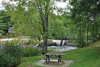
Songo Lock is the last surviving lock of the Cumberland and Oxford Canal, a 19th-century canal in southern Maine, United States. The lock is located on the Songo River, just above its confluence with the Crooked River at the northern end of Sebago Lake State Park in the town of Naples. The lock, built in 1830, is now used primarily during the summer months by pleasure craft. It was listed on the National Register of Historic Places in 1970 and designated as a Maine Historic Civil Engineering Landmark by the American Society of Civil Engineers in 2001.
Hancock Brook is an east-bank tributary to the Saco River at Hiram, Maine. The brook originates in eastern Denmark and flows through a chain of ponds along the border between Hiram and Sebago. The narrow-gauge Bridgton and Saco River Railroad was built along the brook in 1882, and operated until 1941.


