Waterford, Maine

Last updated

Waterford, Maine
Waterford Maine.jpg
View from Blackguard Road
USA Maine location map.svg
Red pog.svg
Waterford, Maine
Location within the state of Maine
Coordinates: 44°11′27″N70°42′27″W / 44.19083°N 70.70750°W / 44.19083; -70.70750
Country United States
State Maine
County Oxford
Incorporated 1797
Area
[1]
  Total52.92 sq mi (137.06 km2)
  Land50.24 sq mi (130.12 km2)
  Water2.68 sq mi (6.94 km2)
Elevation
669 ft (204 m)
Population
 (2020)
  Total1,570
  Density31/sq mi (12.1/km2)
Time zone UTC-5 (Eastern (EST))
  Summer (DST) UTC-4 (EDT)
ZIP code
04088
Area code 207
FIPS code 23-80635
GNIS feature ID0582794

Waterford is a town in Oxford County, Maine, United States. Waterford is included in the Lewiston-Auburn, Maine metropolitan New England city and town area. The population was 1,570 at the 2020 census. [2] It is a recreation area noted for historic architecture and scenery.[ citation needed ]

Contents

History

Waterford from Table Rock in 1905 Waterford, ME from Table Rock.jpg
Waterford from Table Rock in 1905

The township was granted on February 24, 1774, by the Massachusetts General Court to Captain Andrew Gardner and his company of soldiers for services under Sir William Phipps during the 1690 expedition against Canada. It replaced a 1735 grant called Toddstown or Township No. 6 (now Henniker, New Hampshire), which was ruled invalid when the state line was redrawn between Massachusetts and New Hampshire in 1741. [3]

The land was surveyed in 1774; in spring of 1775, David McWain of Bolton, Massachusetts arrived with his dog at a lot he bought for $40. He cleared land and built a log cabin, returning to Bolton for two winters until he settled permanently at Waterford in spring of 1777. McWain preferred solitude, and was deeply annoyed when he first saw smoke rising about 12 miles (19 km) away at Paris Hill. "Humph," he said, "I would like to know who is settling over there right under my nose!" Other grantees arrived nevertheless, most from the Massachusetts towns of Bolton, Harvard, Stow, Northborough and Rowley. Indeed, the northwestern part of the plantation was once known as Rowley after the inhabitants' former hometown. [4]

On March 2, 1797, Waterford was incorporated, with land annexed from Albany in 1811. The surface of the town is uneven and somewhat mountainous. It was well-suited for pasturage and orchards, and agriculture became a principal occupation. Sawmills were built at streams to manufacture the region's abundant timber into lumber. Wood products included window sashes, barrel staves, salt boxes and buckets. There was also a gristmill, carriage factory and tannery. Today, Waterford Flat is a resort area, and home to The Lake House, a 1797 inn set among antique buildings listed on the National Register of Historic Places. [5]

Geography

According to the United States Census Bureau, the town has a total area of 52.92 square miles (137.06 km2), of which 50.24 square miles (130.12 km2) is land and 2.68 square miles (6.94 km2) is water. [1] Waterford is drained by the Crooked River. It contains a number of small lakes including Keoka Lake, McWain Pond, Bear Pond, as well as Mount Tire'm.

The town is traversed by state routes 35, 37 and 118. It is bordered by the towns of Norway to the northeast, Albany and Stoneham to the northwest, Sweden and Lovell to the southwest, and Harrison and Bridgton to the southeast.

Demographics

Historical population
CensusPop.Note
1790 154
1800 535247.4%
1810 86060.7%
1820 1,03520.3%
1830 1,1238.5%
1840 1,38123.0%
1850 1,4484.9%
1860 1,407−2.8%
1870 1,286−8.6%
1880 1,161−9.7%
1890 1,001−13.8%
1900 917−8.4%
1910 9341.9%
1920 765−18.1%
1930 743−2.9%
1940 83612.5%
1950 828−1.0%
1960 8340.7%
1970 760−8.9%
1980 95125.1%
1990 1,29936.6%
2000 1,45512.0%
2010 1,5536.7%
2020 1,5701.1%
U.S. Decennial Census [6]
Home of Thomas Hovey Gage c. 1915, town historian Home of Thomas Hovey Gage, Waterford, ME.jpg
Home of Thomas Hovey Gage c.1915, town historian

2010 census

As of the census [7] of 2010, there were 1,553 people, 667 households, and 471 families living in the town. The population density was 30.9 inhabitants per square mile (11.9/km2). There were 1,084 housing units at an average density of 21.6 per square mile (8.3/km2). The racial makeup of the town was 97.9% White, 0.1% African American, 0.2% Native American, 0.1% from other races, and 1.7% from two or more races. Hispanic or Latino of any race were 0.7% of the population.

There were 667 households, of which 28.0% had children under the age of 18 living with them, 54.3% were married couples living together, 10.3% had a female householder with no husband present, 6.0% had a male householder with no wife present, and 29.4% were non-families. 23.2% of all households were made up of individuals, and 9.7% had someone living alone who was 65 years of age or older. The average household size was 2.33 and the average family size was 2.68.

The median age in the town was 45.9 years. 20.8% of residents were under the age of 18; 6.2% were between the ages of 18 and 24; 21.4% were from 25 to 44; 33.7% were from 45 to 64; and 17.8% were 65 years of age or older. The gender makeup of the town was 49.5% male and 50.5% female.

2000 census

As of the census [8] of 2000, there were 1,455 people, 590 households, and 437 families living in the town. The population density was 28.8 inhabitants per square mile (11.1/km2). There were 895 housing units at an average density of 17.7 inhabitants per square mile (6.8/km2). The racial makeup of the town was 98.83% White, 0.27% Native American, 0.07% Asian, 0.07% Pacific Islander, and 0.76% from two or more races.

There were 590 households, out of which 29.2% had children under the age of 18 living with them, 60.5% were married couples living together, 9.3% had a female householder with no husband present, and 25.9% were non-families. 21.0% of all households were made up of individuals, and 7.6% had someone living alone who was 65 years of age or older. The average household size was 2.46 and the average family size was 2.80.

In the town, the population was spread out, with 23.5% under the age of 18, 6.6% from 18 to 24, 28.0% from 25 to 44, 27.6% from 45 to 64, and 14.2% who were 65 years of age or older. The median age was 40 years. For every 100 females, there were 101.0 males. For every 100 females age 18 and over, there were 97.3 males.

The median income for a household in the town was $31,458, and the median income for a family was $35,000. Males had a median income of $25,560 versus $22,188 for females. The per capita income for the town was $16,416. About 9.5% of families and 13.4% of the population were below the poverty line, including 20.0% of those under age 18 and 7.3% of those age 65 or over.

Site of interest

Notable people

Related Research Articles

<span class="mw-page-title-main">Lisbon, Maine</span> Town in the state of Maine, United States

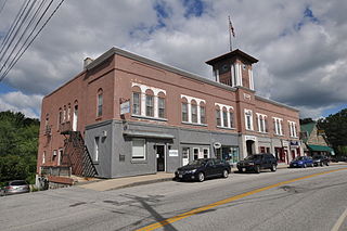
Lisbon is a town in Androscoggin County, Maine, United States. The population was 9,711 at the 2020 census. It is included in both the Lewiston-Auburn, Maine metropolitan statistical area and the Lewiston–Auburn, Maine Metropolitan New England city and town area. The town of Lisbon includes the villages of Lisbon and Lisbon Falls.

<span class="mw-page-title-main">Baldwin, Maine</span> Town in the state of Maine, United States

Baldwin is a town in Cumberland County, Maine, United States. The population was 1,520 at the 2020 census. It is part of the Portland–South Portland–Biddeford, Maine, metropolitan statistical area.

<span class="mw-page-title-main">Casco, Maine</span> Town in the state of Maine, United States

Casco is a town in Cumberland County, Maine, United States. Casco is included in the Lewiston-Auburn, Maine metropolitan New England city and town area. The population was 3,646 at the 2020 census. Casco includes the villages of Casco, South Casco and Cook Mills. The town borders the east shore of Sebago Lake, and is home to part of Sebago Lake State Park. Casco is part of the Portland–South Portland–Biddeford, Maine metropolitan statistical area. Casco is just under 30 miles (48 km) from downtown Portland.

<span class="mw-page-title-main">Harrison, Maine</span> Town in the state of Maine, United States

Harrison is a town in Cumberland County, Maine, United States. Harrison is included in the Lewiston-Auburn, Maine metropolitan New England city and town area. The population was 2,447 at the 2020 census. A historic resort area, Harrison straddles Long Lake and Crystal Lake. It is part of the Portland–South Portland–Biddeford, Maine metropolitan statistical area.

<span class="mw-page-title-main">Sebago, Maine</span> Town in Maine, United States

Sebago is a town in Cumberland County, Maine, United States. The population was 1,911 at the 2020 census. It is part of the Portland–South Portland–Biddeford, Maine metropolitan statistical area.

<span class="mw-page-title-main">Carthage, Maine</span> Town in the state of Maine, United States

Carthage is a town in Franklin County, Maine, United States. The population was 509 at the 2020 census.

<span class="mw-page-title-main">Weld, Maine</span> Town in the state of Maine, United States

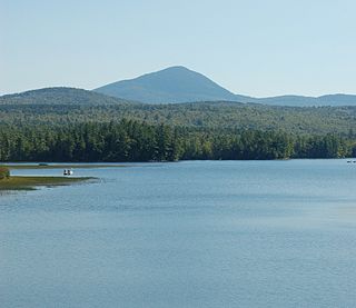
Weld is a town in Franklin County, Maine, United States. The population was 376 at the 2020 census. Set beside Webb Lake and almost surrounded by mountains, Weld is noted for its scenery. It is home to Mount Blue State Park, Camp Kawanhee for Boys, and Camp Lawroweld.

<span class="mw-page-title-main">Monmouth, Maine</span> Town in the state of Maine, United States

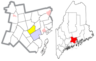
Monmouth is a town in Kennebec County, Maine, United States. Monmouth is included in the Lewiston-Auburn, Maine metropolitan New England city and town area. The population was 4,066 at the 2022 census.

<span class="mw-page-title-main">Rome, Maine</span> Town in the state of Maine, United States

Rome is a town in Kennebec County, Maine, United States. The population was 1,148 at the 2020 census. It is part of the Belgrade Lakes resort area, and is included in the Augusta, Maine, micropolitan New England City and Town Area.

<span class="mw-page-title-main">Alna, Maine</span> Town in the state of Maine, United States

Alna is a town in Lincoln County, Maine, United States. The population was 710 at the 2020 census. Alna is home to the Wiscasset, Waterville and Farmington Railway Museum and is noted for its historic architecture, including the early mill village of Head Tide.

<span class="mw-page-title-main">Bremen, Maine</span> Town in the state of Maine, United States

Bremen is a small town in Lincoln County, Maine, United States. The population was 823 at the 2020 census. Located on Muscongus Bay and the Gulf of Maine, it includes the villages of Broad Cove, Turners Corner, Bremen, Medomak and Muscongus. Hog Island is a center and camp for the Maine chapter of the National Audubon Society.

<span class="mw-page-title-main">Canton, Maine</span> Town in the state of Maine, United States

Canton is a town in Oxford County, Maine, United States. Canton is included in the Lewiston-Auburn, Maine metropolitan New England city and town area. The population was 1,125 at the 2020 census. Located beside Lake Anasagunticook, Canton is a summer recreational area.

<span class="mw-page-title-main">Hebron, Maine</span> Town in the state of Maine, United States

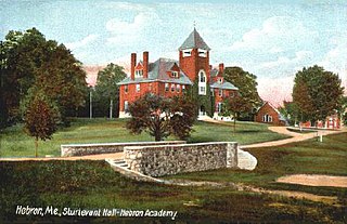
Hebron is a town in Oxford County, Maine, United States. Hebron is included in the Lewiston-Auburn, Maine metropolitan New England city and town area. The town's history has always been interconnected with Hebron Academy, a co-ed college preparatory boarding school which is located in the town's heart. The population was 1,223 at the 2020 census. There is an elementary school, Hebron Station School, located on Station Road.

Otisfield is a town in Oxford County, Maine, United States. Otisfield is included in the Lewiston-Auburn, Maine metropolitan New England city and town area. The population was 1,853 at the 2020 census. Otisfield is a summer recreation area and home to Seeds of Peace Camp and Camp Arcadia.

<span class="mw-page-title-main">Porter, Maine</span> Town in the state of Maine, United States

Porter is a town in Oxford County, Maine, United States. It is included in the Portland-South Portland-Biddeford, Maine metropolitan New England City and Town Area. Porter includes Porter village and part of Kezar Falls. The population was 1,600 at the 2020 census.

<span class="mw-page-title-main">Roxbury, Maine</span> Town in the state of Maine, United States

Roxbury is a town in Oxford County, Maine, United States. The population was 361 at the 2020 census. Ellis Pond is popular with recreational fishermen.

Sweden is a town in Oxford County, Maine, United States. The population was 406 at the 2020 census. Set among hills, forests and ponds, Sweden includes the village of East Sweden.

<span class="mw-page-title-main">Bowdoin, Maine</span> Town in the state of Maine, United States

Bowdoin is a town in Sagadahoc County, Maine, United States. Bowdoin is included in the Lewiston-Auburn, Maine metropolitan New England city and town area. The population was 3,136 at the 2020 census. Bowdoin is 31 land miles north of Portland, and 21 land miles south of Augusta.

<span class="mw-page-title-main">Solon, Maine</span> Town in the state of Maine, United States

Solon is a town in Somerset County, Maine, United States. The population was 978 at the 2020 census.

<span class="mw-page-title-main">Waldo, Maine</span> Town in the state of Maine, United States

Waldo is a town in Waldo County, Maine, United States. The population was 795 at the 2020 census. It is the home town of Heather Hemmens, who is known for her role on Hellcats.

References

  1. 1 2 "US Gazetteer files 2010". United States Census Bureau . Retrieved December 16, 2012.
  2. "Census - Geography Profile: Waterford town, Oxford County, Maine" . Retrieved January 19, 2022.
  3. Coolidge, Austin J.; John B. Mansfield (1859). A History and Description of New England. Boston, Massachusetts: A.J. Coolidge. pp.  343–344. coolidge mansfield history description new england 1859.
  4. George J. Varney, History of Waterford, Maine; Boston, Massachusetts 1886
  5. Maine.gov -- Waterford, Maine
  6. "Census of Population and Housing". Census.gov. Retrieved June 4, 2015.
  7. "U.S. Census website". United States Census Bureau . Retrieved December 16, 2012.
  8. "U.S. Census website". United States Census Bureau . Retrieved January 31, 2008.