Oxford, Maine

Last updated

Oxford, Maine
Congregational Church, Oxford, ME.jpg
USA Maine location map.svg
Red pog.svg
Oxford, Maine
Location within the state of Maine
Coordinates: 44°07′37″N70°29′42″W / 44.12694°N 70.49500°W / 44.12694; -70.49500
CountryUnited States
State Maine
County Oxford
Incorporated1829
Area
[1]
  Total41.88 sq mi (108.47 km2)
  Land38.72 sq mi (100.28 km2)
  Water3.16 sq mi (8.18 km2)
Population
 (2020)
  Total4,229
  Density109.2/sq mi (42.17/km2)
Time zone UTC-5 (Eastern (EST))
  Summer (DST) UTC-4 (EDT)
Website www.oxfordmaine.org

Oxford is a town in Oxford County, Maine, United States. Oxford is included in the Lewiston-Auburn, Maine metropolitan New England city and town area. The population was 4,229 at the 2020 census. [2] Oxford is home to the Oxford Plains Speedway, Kamp Kohut, the annual Oxford County Fair, and Oxford Casino. The town includes the village of Welchville.

Contents

History

The land was part of Plantation (also called Bog Brook Plantation), granted on March 8, 1777, by the Massachusetts General Court to Alexander Shepard Jr. of Newton, Massachusetts. On March 6, 1792, the plantation was incorporated as Hebron, with Oxford its southwesterly portion. First settled in 1794, Oxford was set off and incorporated on February 27, 1829. It annexed land from Otisfield in 1830, and from Paris in 1838. [3] The town was named after Oxford, in England. [4]

Farmers grew mostly hay, and the town became noted for cattle. Mills were established at 2 water power sites; these developed in the 19th-century into principal villages within the town, especially after the arrival of the Grand Trunk Railway in the 1850s. Welchville was located on the Little Androscoggin River, where the woolen textile mill of the Harper Manufacturing Company was established. At the outlet of Thompson Lake was Oxford village, first called Craigie's Mill for the sawmill and gristmill built by Andrew Craigie, a Boston apothecary and land speculator. This was also the site of a grisly murder that, to this day, goes unsolved[ citation needed ]. Here were erected a barrel stave mill, a shovel handle factory, and the woolen textile mills of the Robinson Manufacturing Company. The railroad brought seasonal tourists to Thompson Lake, where inns and hotels opened. Today, Oxford is a recreational area with fine architecture remaining from its prosperous mill town past. The Congregational Church, built in 1842–1843, is listed on the National Register of Historic Places. [5]

The town was hit by an F1 tornado on Saturday, June 5, 2010, causing some serious damage.

Geography

According to the United States Census Bureau, the town has a total area of 41.88 square miles (108.47 km2), of which 38.72 square miles (100.28 km2) is land and 3.16 square miles (8.18 km2) is water. [1] Oxford is drained by the Little Androscoggin River. Thompson Lake, the community's largest, is approximately 8 miles (13 km) long.

The town is served by state routes 26 and 121. It borders the towns of Paris to the north, Hebron to the northeast, Norway to the northwest, Poland to the southeast, and Otisfield to the southwest.

Demographics

Historical population
CensusPop.Note
1800 69
1830 1,116
1840 1,25412.4%
1850 1,233−1.7%
1860 1,2813.9%
1870 1,63127.3%
1880 1,6551.5%
1890 1,455−12.1%
1900 1,331−8.5%
1910 1,221−8.3%
1920 1,097−10.2%
1930 1,1252.6%
1940 1,31617.0%
1950 1,56919.2%
1960 1,6585.7%
1970 1,89214.1%
1980 3,14366.1%
1990 3,70517.9%
2000 3,9606.9%
2010 4,1103.8%
2020 4,2292.9%
U.S. Decennial Census [6]

2010 census

As of the census [7] of 2010, there were 4,110 people, 1,657 households, and 1,107 families living in the town. The population density was 106.1 inhabitants per square mile (41.0/km2). There were 2,170 housing units at an average density of 56.0 per square mile (21.6/km2). The racial makeup of the town was 97.2% White, 0.3% African American, 0.4% Native American, 0.1% Asian, 0.2% from other races, and 1.7% from two or more races. Hispanic or Latino of any race were 1.1% of the population.

There were 1,657 households, of which 31.0% had children under the age of 18 living with them, 50.6% were married couples living together, 10.2% had a female householder with no husband present, 6.0% had a male householder with no wife present, and 33.2% were non-families. 23.2% of all households were made up of individuals, and 8.5% had someone living alone who was 65 years of age or older. The average household size was 2.48 and the average family size was 2.88.

The median age in the town was 42.4 years. 21.8% of residents were under the age of 18; 6.9% were between the ages of 18 and 24; 25.4% were from 25 to 44; 32.2% were from 45 to 64; and 13.8% were 65 years of age or older. The gender makeup of the town was 50.1% male and 49.9% female.

2000 census

As of the census [8] of 2000, there were 3,960 people, 1,487 households, and 1,094 families living in the town. The population density was 102.3 inhabitants per square mile (39.5/km2). There were 1,926 housing units at an average density of 49.8 per square mile (19.2/km2). The racial makeup of the town was 97.88% White, 0.25% Black or African American, 0.25% Native American, 0.28% Asian, 0.03% Pacific Islander, 0.23% from other races, and 1.09% from two or more races. Hispanic or Latino of any race were 0.63% of the population.

There were 1,487 households, out of which 36.0% had children under the age of 18 living with them, 58.8% were married couples living together, 9.1% had a female householder with no husband present, and 26.4% were non-families. 19.0% of all households were made up of individuals, and 8.2% had someone living alone who was 65 years of age or older. The average household size was 2.66 and the average family size was 3.00.

In the town, the population was spread out, with 26.5% under the age of 18, 6.6% from 18 to 24, 30.4% from 25 to 44, 24.4% from 45 to 64, and 12.1% who were 65 years of age or older. The median age was 38 years. For every 100 females, there were 96.6 males. For every 100 females age 18 and over, there were 94.5 males.

The median income for a household in the town was $36,670, and the median income for a family was $38,438. Males had a median income of $27,957 versus $20,392 for females. The per capita income for the town was $15,480. About 2.8% of families and 7.1% of the population were below the poverty line, including 4.6% of those under age 18 and 12.0% of those age 65 or over.

Government

The town of Oxford is governed by an elected, five-person Board of Selectmen and an appointed town manager. The town's police department consists of one Chief of Police, one captain, two sergeants, four full-time patrol officers and several reserve (part-time) patrol officers.[ citation needed ] The town has an on-call fire rescue department made up of several dedicated members. It is run by a fire chief, two deputy chiefs, and several officers. The fire department also employs fire police for traffic control at various calls and events.

People

See also

Related Research Articles

<span class="mw-page-title-main">Minot, Maine</span> Town in the state of Maine, United States

Minot is a town in Androscoggin County, Maine, United States. The population was 2,766 at the 2020 census. The town includes the villages of West Minot and Minot Center. It is part of both the Lewiston-Auburn, Maine metropolitan statistical area and the Lewiston-Auburn, Maine metropolitan New England city and town area.

<span class="mw-page-title-main">Casco, Maine</span> Town in the state of Maine, United States

Casco is a town in Cumberland County, Maine, United States. Casco is included in the Lewiston-Auburn, Maine metropolitan New England city and town area. The population was 3,646 at the 2020 census. Casco includes the villages of Casco, South Casco and Cook Mills. The town borders the east shore of Sebago Lake, and is home to part of Sebago Lake State Park. Casco is part of the Portland–South Portland–Biddeford, Maine metropolitan statistical area. Casco is just under 30 miles (48 km) from downtown Portland.

<span class="mw-page-title-main">Harrison, Maine</span> Town in the state of Maine, United States

Harrison is a town in Cumberland County, Maine, United States. Harrison is included in the Lewiston-Auburn, Maine metropolitan New England city and town area. The population was 2,447 at the 2020 census. A historic resort area, Harrison straddles Long Lake and Crystal Lake. It is part of the Portland–South Portland–Biddeford, Maine metropolitan statistical area.

<span class="mw-page-title-main">Naples, Maine</span> Town in the United States

Naples is a town in Cumberland County, Maine, United States. It is part of the Portland–South Portland–Biddeford, Maine metropolitan statistical area. The population was 3,925 at the 2020 census, and it is home to part of Sebago Lake State Park. Naples is a resort area.

<span class="mw-page-title-main">Carthage, Maine</span> Town in the state of Maine, United States

Carthage is a town in Franklin County, Maine, United States. The population was 509 at the 2020 census.

<span class="mw-page-title-main">Monmouth, Maine</span> Town in the state of Maine, United States

Monmouth is a town in Kennebec County, Maine, United States. Monmouth is included in the Lewiston-Auburn, Maine metropolitan New England city and town area. The population was 4,066 at the 2022 census.

<span class="mw-page-title-main">Canton, Maine</span> Town in the state of Maine, United States

Canton is a town in Oxford County, Maine, United States. Canton is included in the Lewiston-Auburn, Maine metropolitan New England city and town area. The population was 1,125 at the 2020 census. Located beside Lake Anasagunticook, Canton is a summer recreational area.

<span class="mw-page-title-main">Hebron, Maine</span> Town in the state of Maine, United States

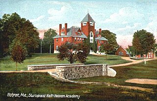
Hebron is a town in Oxford County, Maine, United States. Hebron is included in the Lewiston-Auburn, Maine metropolitan New England city and town area. The town's history has always been interconnected with Hebron Academy, a co-ed college preparatory boarding school which is located in the town's heart. The population was 1,223 at the 2020 census. There is an elementary school, Hebron Station School, located on Station Road.

Otisfield is a town in Oxford County, Maine, United States. Otisfield is included in the Lewiston-Auburn, Maine metropolitan New England city and town area. The population was 1,853 at the 2020 census. Otisfield is a summer recreation area and home to Seeds of Peace Camp and Camp Arcadia.

<span class="mw-page-title-main">Roxbury, Maine</span> Town in the state of Maine, United States

Roxbury is a town in Oxford County, Maine, United States. The population was 361 at the 2020 census. Ellis Pond is popular with recreational fishermen.

<span class="mw-page-title-main">South Paris, Maine</span> CDP in Maine, United States

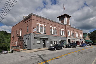
South Paris is a census-designated place (CDP) located within the town of Paris in Oxford County, Maine, United States. South Paris is included in the Lewiston-Auburn, Maine metropolitan New England city and town area.The population was 2,237 at the 2000 census. While the CDP refers only to the densely settled area in the southern part of the town of Paris, the entire town, outside of Paris Hill, is located within the South Paris ZIP code, resulting in many residents referring to the entire town as South Paris.

<span class="mw-page-title-main">Sumner, Maine</span> Town in the state of Maine, United States

Sumner is a town in Oxford County, Maine, United States. Sumner is included in the Lewiston-Auburn, Maine metropolitan New England city and town area. The population was 994 at the 2020 census. The town includes the villages of West Sumner and East Sumner.

<span class="mw-page-title-main">Acton, Maine</span> Town in the state of Maine, United States

Acton is a town in York County, Maine, United States. The population was 2,671 at the 2020 census. It includes the villages of Acton, Miller Corner and South Acton. The town is home to the Acton Fairground, which holds the Acton Fair every late summer. It is part of the Portland–South Portland–Biddeford, Maine metropolitan statistical area.

<span class="mw-page-title-main">Dayton, Maine</span> Town in the state of Maine, United States

Dayton is a town in York County, Maine, United States; the town is located near the Saco-Biddeford city area. Dayton borders Biddeford by land, and borders Saco on the Saco River. It is also part of the Portland–South Portland–Biddeford, Maine metropolitan statistical area. The population was 2,129 at the 2020 census. Dayton is one of the smallest towns in York County.

<span class="mw-page-title-main">Hollis, Maine</span> Town in the state of Maine, United States

Hollis is a town in York County, Maine, United States. The population was 4,745 at the 2020 census. Hollis is a rural bedroom community of Portland and is part of the Portland–South Portland–Biddeford metropolitan statistical area.

<span class="mw-page-title-main">Newfield, Maine</span> Town in the state of Maine, United States

Newfield is a town in York County, Maine, United States. The population was 1,648 at the 2020 census. The town is part of the Portland–South Portland–Biddeford metropolitan statistical area.

<span class="mw-page-title-main">Waterboro, Maine</span> Town in Maine, United States

Waterboro is a town in York County, Maine, United States. The population was 7,936 at the 2020 census. It is part of the Portland–South Portland–Biddeford, Maine metropolitan statistical area.

<span class="mw-page-title-main">Dixfield, Maine</span> Town in the state of Maine, United States

Dixfield is a town in Oxford County, Maine, United States. Dixfield is included in the Lewiston-Auburn, Maine metropolitan New England city and town area. The population was 2,253 at the 2020 census. The town motto of Dixfield is "The Only One", because it is the only town in the world to claim that name. Dr. Elijeh Dix, a substantial landowner in the area, bought the town which bears his name.

Oxford is a census-designated place (CDP) in the town of Oxford in Oxford County, Maine, United States. The population was 1,300 at the 2000 census.

<span class="mw-page-title-main">Pittsfield, Maine</span> Town in Maine, United States

Pittsfield is a town in Somerset County, Maine, United States. The population was 3,908 at the 2020 census. Pittsfield is home to the Maine Central Institute, a semi-private boarding school, and the annual Central Maine Egg Festival.

References

  1. 1 2 "US Gazetteer files 2010". United States Census Bureau . Retrieved December 16, 2012.
  2. "Census - Geography Profile: Oxford town, Oxford County, Maine" . Retrieved January 13, 2022.
  3. Coolidge, Austin J.; John B. Mansfield (1859). A History and Description of New England. Boston, Massachusetts: A.J. Coolidge. p.  244. coolidge mansfield history description new england 1859.
  4. Yates, Edgar A.P. (June 13, 1928). "Some Maine town names". The Lewiston Daily Sun. p. 4. Retrieved October 17, 2015.
  5. Varney, George J. (1886), Gazetteer of the state of Maine. Oxford, Boston: Russell
  6. "Census of Population and Housing". Census.gov. Retrieved June 4, 2015.
  7. "U.S. Census website". United States Census Bureau . Retrieved December 16, 2012.
  8. "U.S. Census website". United States Census Bureau . Retrieved January 31, 2008.

Further reading

44°07′37″N70°29′42″W / 44.12694°N 70.49500°W / 44.12694; -70.49500