Lincoln Plantation, Maine

Last updated
Lincoln Plantation, Maine
BENNETT BRIDGE.jpg
Bennett Bridge
USA Maine location map.svg
Red pog.svg
Lincoln Plantation, Maine
Location within the state of Maine
Coordinates: 44°57′N71°00′W / 44.950°N 71.000°W / 44.950; -71.000
Country United States
State Maine
County Oxford
Area
  Total36.8 sq mi (95.4 km2)
  Land32.5 sq mi (84.1 km2)
  Water4.4 sq mi (11.3 km2)
Population
 (2020)
  Total41
  Density1.1/sq mi (0.43/km2)
Time zone UTC-5 (Eastern (EST))
  Summer (DST) UTC-4 (EDT)
ZIP code
03579
Area code 207
FIPS code 23-39422
GNIS feature ID0582560

Lincoln Plantation is a plantation in Oxford County, Maine, United States. It contains the village of Wilson's Mills. The population was 41 at the 2020 census. [1]

Contents

Geography

According to the United States Census Bureau, the plantation has a total area of 36.8 square miles (95.4 km2), of which 32.5 square miles (84.1 km2) is land and 4.4 square miles (11.3 km2) (11.83%) is water. The southern portion of the Aziscohos Lake reservoir is located in the plantation, along with the Aziscohos Dam on the Magalloway River that impounds the reservoir. [2] Lincoln Plantation is also home to Aziscohos Mountain, whose summit sits at an elevation of 3,215 feet (980 m). [3]

Demographics

Historical population
CensusPop.Note
1930 90
1940 89−1.1%
1950 71−20.2%
1960 9939.4%
1970 60−39.4%
1980 50−16.7%
1990 38−24.0%
2000 4621.1%
2010 45−2.2%
2020 41−8.9%
U.S. Decennial Census [4]

As of the census [5] of 2000, there were 46 people, 24 households, and 19 families residing in the plantation. The population density was 1.4 people per square mile (0.5/km2). There were 119 housing units at an average density of 3.7 per square mile (1.4/km2). The racial makeup of the plantation was 100.00% White.

There were 24 households, out of which 4.2% had children under the age of 18 living with them, 66.7% were married couples living together, 4.2% had a female householder with no husband present, and 20.8% were non-families. 20.8% of all households were made up of individuals, and 8.3% had someone living alone who was 65 years of age or older. The average household size was 1.92 and the average family size was 2.11.

In the plantation the population was spread out, with 2.2% under the age of 18, 6.5% from 18 to 24, 8.7% from 25 to 44, 56.5% from 45 to 64, and 26.1% who were 65 years of age or older. The median age was 56 years. For every 100 females, there were 109.1 males. For every 100 females age 18 and over, there were 114.3 males.

The median income for a household in the plantation was $26,750, and the median income for a family was $31,563. Males had a median income of $36,250 versus $12,500 for females. The per capita income for the plantation was $17,376. None of the population and none of the families were below the poverty line.

Related Research Articles

<span class="mw-page-title-main">Oxford County, Maine</span> County in Maine, United States

Oxford County is a county in the state of Maine, United States. As of the 2020 Census, the county had a population of 57,777. Its county seat is the town of Paris. The county was formed on March 4, 1805, by the Massachusetts General Court in the Maine District from northerly portions of York and Cumberland counties. It borders the Canadian province of Quebec. Part of Oxford County is included in the Lewiston-Auburn, Maine metropolitan New England City and Town Area while a different part of Oxford County is included in the Portland-South Portland-Biddeford, Maine metropolitan New England City and Town Area.

<span class="mw-page-title-main">Macwahoc Plantation, Maine</span> Plantation in Maine, United States

Macwahoc Plantation is a plantation in Aroostook County, Maine, United States. The population was 62 at the 2020 census.

<span class="mw-page-title-main">Saint John Plantation, Maine</span> Plantation in Maine, United States

Saint John Plantation is a plantation in Aroostook County, Maine, United States, on the banks of the Saint John River. The population was 263 at the 2020 census.

<span class="mw-page-title-main">Winterville Plantation, Maine</span> Plantation in Maine, United States

Winterville Plantation is a plantation in Aroostook County, Maine, United States. The population was 194 at the 2020 census.

<span class="mw-page-title-main">Carthage, Maine</span> Town in the state of Maine, United States

Carthage is a town in Franklin County, Maine, United States. The population was 509 at the 2020 census.

<span class="mw-page-title-main">Dallas Plantation, Maine</span> Plantation in Maine, United States

Dallas Plantation is a plantation in Franklin County, Maine, United States. The population was 304 at the 2020 census.

<span class="mw-page-title-main">Sandy River Plantation, Maine</span> Plantation in Maine, United States

Sandy River Plantation is a plantation in Franklin County, Maine, United States. The population was 128 at the 2020 census. It is home to the popular Saddleback Mountain Ski Resort and the Rangeley Lakes Nordic Trail Center.

<span class="mw-page-title-main">Hebron, Maine</span> Town in the state of Maine, United States

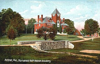
Hebron is a town in Oxford County, Maine, United States. Hebron is included in the Lewiston-Auburn, Maine metropolitan New England city and town area. The town's history has always been interconnected with Hebron Academy, a co-ed college preparatory boarding school which is located in the town's heart. The population was 1,223 at the 2020 census. There is an elementary school, Hebron Station School, located on Station Road.

<span class="mw-page-title-main">Magalloway Plantation, Maine</span> Plantation in Maine, United States

Magalloway Plantation was a plantation in Oxford County, Maine, United States, which de-organized in 2021. The population was 45 at the 2020 census. Part of the Umbagog National Wildlife Refuge is located at its southwestern corner.

Woodstock is a town in Oxford County, Maine, United States. The population was 1,352 at the 2020 census. The village of Bryant Pond, on State Route 26 in the northern part of Woodstock, is the town's urban center and largest settlement.

Carroll Plantation is a plantation in Penobscot County, Maine, United States. The plantation was named for Daniel Carroll, a signatory of the United States Constitution. It is located along Maine State Route 6 near its intersection with State Route 170. The population was 138 at the 2020 census. It is part of the Bangor Metropolitan Statistical Area.

Seboeis Plantation is a plantation in Penobscot County, Maine, United States. The population was 40 at the 2020 census.

Webster Plantation is a plantation in Penobscot County, Maine, United States. The population was 68 at the 2020 census.

<span class="mw-page-title-main">Lake View Plantation, Maine</span> Plantation in Maine, United States

Lake View is a plantation in Piscataquis County, Maine, United States. The population was 150 at the 2020 census.

Dennistown is a plantation in Somerset County, Maine, United States. The population was 61 at the 2020 census.

Pleasant Ridge Plantation is a plantation in Somerset County, Maine, United States. The population was 85 at the 2020 census.

Baring Plantation is a plantation in Washington County, Maine, United States. The population was 201 at the 2020 census. The plantation is named for Alexander Baring, 1st Baron Ashburton, the British negotiator of the Webster–Ashburton Treaty which ended the Aroostook War in 1838–1839.

Codyville is an unorganized territory (township) in Washington County, Maine, United States. The population was 13 at the 2020 census.

Milton is an unorganized territory (township) in Oxford County, Maine, United States. The population was 150 at the 2020 census. The township was formerly a plantation that surrendered its organization in 1939.

<span class="mw-page-title-main">Oxford, Maine</span> Town in the state of Maine, United States

Oxford is a town in Oxford County, Maine, United States. The population was 4,229 at the 2020 census. Oxford is home to the Oxford Plains Speedway, Kamp Kohut, the annual Oxford County Fair, and Oxford Casino. The town includes the village of Welchville.

References

  1. "Census - Geography Profile: Lincoln plantation, Oxford County, Maine". United States Census Bureau . Retrieved January 9, 2022.
  2. "Aziscohos Lake" (PDF). Maine Department of Inland Fisheries and Game. State of Maine. Archived from the original (PDF) on 2 June 2016. Retrieved 3 May 2016.
  3. "AZISCOHOS MOUNTAIN, NEAR RANGELEY (LINCOLN PLANTATION)". Maine By Foot. Retrieved June 23, 2020.
  4. "Census of Population and Housing". Census.gov. Retrieved June 23, 2020.
  5. "US Census 2000 Lincoln Plantation". Archived from the original on 2020-02-12. Retrieved 2007-02-23.