Andover, Maine

Last updated

Andover, Maine
Main Street, Andover, ME.jpg
Main Street c.1906
Andover Maine Seal.png
USA Maine location map.svg
Red pog.svg
Andover, Maine
Location within the state of Maine
Usa edcp location map.svg
Red pog.svg
Andover, Maine
Andover, Maine (the United States)
North America laea location map.svg
Red pog.svg
Andover, Maine
Andover, Maine (North America)
Coordinates: 44°38′3″N70°45′9″W / 44.63417°N 70.75250°W / 44.63417; -70.75250
Country United States
State Maine
County Oxford
Incorporated1804
Area
[1]
  Total57.46 sq mi (148.82 km2)
  Land57.42 sq mi (148.72 km2)
  Water0.04 sq mi (0.10 km2)
Elevation
669 ft (204 m)
Population
 (2020) [2]
  Total752
  Density14.3/sq mi (5.5/km2)
Time zone UTC-5 (Eastern (EST))
  Summer (DST) UTC-4 (EDT)
ZIP code
04216
Area code 207
FIPS code 23-01325
GNIS feature ID0582325

Andover is a town in Oxford County, Maine, United States. The population was 752 at the 2020 census. Set among mountains and crossed by the Appalachian Trail, Andover is home to the Lovejoy Covered Bridge and is the site of the Andover Earth Station.

Contents

History

The land which became known as Andover was originally purchased in 1788 by a group of proprietors mostly from Andover, Massachusetts. The original proprietors were Jonathan Abbot, Philip Abbott, Ebenezer Adams, Ingalls Bragg, Samuel Farnum, Samuel Johnson, Abiel Lovejoy, Benjamin Poor, Eben Poor, Jr., and Theodore Stevens, all of Andover, Massachusetts; John York of Bethel, Massachusetts; Joseph Frye of Fryeburg, Massachusetts; and Josiah Bean, Ezekiel Merrill, and Thomas Poor of Methuen, Massachusetts. The town was first settled in 1789 by Ezekiel Merrill and his family who were transported there from Bethel, Maine, in canoes managed by members of the local Pequawket tribe. The first saw-mill was built on the East Branch of the Ellis River by Col. Thomas Poor in 1791 and was used to provide the lumber for the still standing Merrill-Poor House. [3]

The town was incorporated on June 23, 1804, as East Andover, and then renamed Andover in 1820 when Maine separated from Massachusetts. [4]

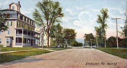
Occupations for early inhabitants primarily included agriculture and lumbering. As the town developed, local factories made doors, sash, blinds, starch, cheese, boots, shoes, edge-tools, carriages, and harness. The town also had a tannery. Located on an intervale surrounded by mountains, Andover is noted for "its grand and beautiful scenery," with streams abounding in trout. After the Civil War, the town became a popular destination for sportsmen, especially fishermen attracted by the nearby Richardson Lakes. A hotel was built to accommodate the influx of tourists. [5]

In 1960, Andover was selected to be site of the Andover Earth Station, completed in 1962. It was the location of the first live transatlantic television signal broadcast by satellite Telstar 1.

Geography

According to the United States Census Bureau, the town has a total area of 57.46 square miles (148.82 km2), of which 57.42 square miles (148.72 km2) is land and 0.04 square miles (0.10 km2) is water. [1] Crossed by the Appalachian Trail, Andover is drained by the Ellis River, a tributary of the Androscoggin River. The river is home to many fish and wildlife, from which avid hunters and fisherman try their luck.

The town is crossed by state routes 5 and 120. It borders the towns of Roxbury and Byron to the east, Rumford to the south, Newry to the southwest, Andover West Surplus to the west, and Andover North Surplus to the north.

Climate

This climatic region is typified by large seasonal temperature differences, with warm to hot (and often humid) summers and cold (sometimes severely cold) winters. According to the Köppen Climate Classification system, Andover has a humid continental climate, abbreviated "Dfb" on climate maps. [6]

Climate data for Andover 2, Maine 1991–2020 normals: 822ft (251m)
MonthJanFebMarAprMayJunJulAugSepOctNovDecYear
Record high °F (°C)54
(12)
68
(20)
77
(25)
89
(32)
92
(33)
95
(35)
97
(36)
94
(34)
94
(34)
83
(28)
75
(24)
59
(15)
97
(36)
Mean maximum °F (°C)43
(6)
46
(8)
54
(12)
75
(24)
82
(28)
87
(31)
89
(32)
87
(31)
83
(28)
72
(22)
62
(17)
48
(9)
90
(32)
Mean daily maximum °F (°C)24.4
(−4.2)
27.7
(−2.4)
36.5
(2.5)
49.9
(9.9)
64.2
(17.9)
72.3
(22.4)
77.3
(25.2)
76.6
(24.8)
68.5
(20.3)
54.8
(12.7)
42.1
(5.6)
30.3
(−0.9)
52.0
(11.1)
Daily mean °F (°C)14.0
(−10.0)
15.7
(−9.1)
25.7
(−3.5)
38.4
(3.6)
51.5
(10.8)
60.4
(15.8)
65.6
(18.7)
64.0
(17.8)
56.3
(13.5)
44.1
(6.7)
33.1
(0.6)
21.4
(−5.9)
40.9
(4.9)
Mean daily minimum °F (°C)3.5
(−15.8)
3.6
(−15.8)
14.8
(−9.6)
26.9
(−2.8)
38.8
(3.8)
48.5
(9.2)
53.9
(12.2)
51.3
(10.7)
44.1
(6.7)
33.4
(0.8)
24.0
(−4.4)
12.5
(−10.8)
29.6
(−1.3)
Mean minimum °F (°C)−12
(−24)
−9
(−23)
−6
(−21)
17
(−8)
28
(−2)
37
(3)
45
(7)
42
(6)
31
(−1)
23
(−5)
10
(−12)
−4
(−20)
−13
(−25)
Record low °F (°C)−30
(−34)
−20
(−29)
−16
(−27)
8
(−13)
23
(−5)
28
(−2)
39
(4)
35
(2)
26
(−3)
13
(−11)
0
(−18)
−17
(−27)
−30
(−34)
Average precipitation inches (mm)3.41
(87)
2.71
(69)
3.48
(88)
4.54
(115)
4.37
(111)
5.38
(137)
4.75
(121)
4.33
(110)
4.02
(102)
5.88
(149)
4.48
(114)
4.28
(109)
51.63
(1,312)
Average snowfall inches (cm)22.50
(57.2)
26.50
(67.3)
17.60
(44.7)
7.00
(17.8)
0.20
(0.51)
0.00
(0.00)
0.00
(0.00)
0.00
(0.00)
0.00
(0.00)
0.60
(1.5)
8.30
(21.1)
29.10
(73.9)
111.8
(284.01)
Source 1: NOAA [7]
Source 2: XMACIS (temp records & monthly max/mins) [8]

Demographics

Historical population
CensusPop.Note
1810 271
1820 36835.8%
1830 3998.4%
1840 55138.1%
1850 71028.9%
1860 81414.6%
1870 757−7.0%
1880 7803.0%
1890 740−5.1%
1900 727−1.8%
1910 7574.1%
1920 7671.3%
1930 7882.7%
1940 757−3.9%
1950 756−0.1%
1960 7620.8%
1970 7913.8%
1980 8507.5%
1990 95312.1%
2000 864−9.3%
2010 821−5.0%
2020 752−8.4%
U.S. Decennial Census [9]

2010 census

As of the census [2] of 2010, there were 821 people, 385 households, and 253 families living in the town. The population density was 14.3 inhabitants per square mile (5.5/km2). There were 603 housing units at an average density of 10.5 per square mile (4.1/km2). The racial makeup of the town was 98.8% White, 0.4% Native American, 0.4% Asian, and 0.5% from two or more races.

There were 385 households, of which 20.5% had children under the age of 18 living with them, 52.5% were married couples living together, 7.8% had a female householder with no husband present, 5.5% had a male householder with no wife present, and 34.3% were non-families. 28.3% of all households were made up of individuals, and 12.7% had someone living alone who was 65 years of age or older. The average household size was 2.13 and the average family size was 2.57.

The median age in the town was 51.1 years. 15.6% of residents were under the age of 18; 4.7% were between the ages of 18 and 24; 20.5% were from 25 to 44; 35.3% were from 45 to 64; and 23.9% were 65 years of age or older. The gender makeup of the town was 50.7% male and 49.3% female.

2000 census

Town Hall AndoverME TownHall.jpg
Town Hall

As of the census [10] of 2000, there were 864 people, 359 households, and 257 families living in the town. The population density was 15.1 inhabitants per square mile (5.8/km2). There were 553 housing units at an average density of 9.6 per square mile (3.7/km2). The racial makeup of the town was 98.96% White, 0.46% African American, 0.12% Native American, 0.12% from other races, and 0.35% from two or more races. Hispanic or Latino of any race were 0.35% of the population.

There were 359 households, out of which 27.6% had children under the age of 18 living with them, 61.8% were married couples living together, 5.8% had a female householder with no husband present, and 28.4% were non-families. 23.4% of all households were made up of individuals, and 9.2% had someone living alone who was 65 years of age or older. The average household size was 2.41 and the average family size was 2.81.

In the town, the population was spread out, with 23.3% under the age of 18, 3.5% from 18 to 24, 28.0% from 25 to 44, 30.7% from 45 to 64, and 14.6% who were 65 years of age or older. The median age was 42 years. For every 100 females, there were 99.5 males. For every 100 females age 18 and over, there were 100.3 males.

The median income for a household in the town was $36,058, and the median income for a family was $40,855. Males had a median income of $32,031 versus $20,000 for females. The per capita income for the town was $20,253. About 9.0% of families and 12.2% of the population were below the poverty line, including 18.3% of those under age 18 and 13.3% of those age 65 or over.

Sites of interest

Lovejoy Covered Bridge AndoverME LovejoyBridge 2.jpg
Lovejoy Covered Bridge

Notable people

Related Research Articles

<span class="mw-page-title-main">Turner, Maine</span> Town in the state of Maine, United States

Turner is a town in Androscoggin County, Maine, United States. The population was 5,817 at the 2020 census. The town includes the villages of Turner, Turner Center and North Turner. The town is part of the Lewiston-Auburn, Maine Metropolitan New England City and Town Area.

<span class="mw-page-title-main">Merrill, Maine</span> Town in the state of Maine, United States

Merrill is a town in Aroostook County, Maine, United States. The population was 208 at the 2020 census.

<span class="mw-page-title-main">Weld, Maine</span> Town in the state of Maine, United States

Weld is a town in Franklin County, Maine, United States. The population was 376 at the 2020 census. Set beside Webb Lake and almost surrounded by mountains, Weld is noted for its scenery. It is home to Mount Blue State Park, Camp Kawanhee for Boys, and Camp Lawroweld.

<span class="mw-page-title-main">Albion, Maine</span> Town in the state of Maine, United States

Albion is a town in Kennebec County, Maine, United States. The population was 2,006 at the 2020 census.

<span class="mw-page-title-main">Wayne, Maine</span> Town in the state of Maine, United States

Wayne is a town in Kennebec County, Maine, United States. Wayne is included in the Lewiston-Auburn, Maine metropolitan New England city and town area. The population was 1,129 at the 2020 census. The town was named after Revolutionary War General Anthony Wayne. During the summer, Wayne is home to Camp Androscoggin. A popular recreation spot in central Maine, Wayne is part of the Winthrop Lakes Region. The town is included in the Augusta, Maine micropolitan New England City and Town Area. and included in the Lewiston-Auburn, Maine metropolitan New England city and town area.

<span class="mw-page-title-main">Jefferson, Maine</span> Town in the state of Maine, United States

Jefferson is a town in Lincoln County, Maine, United States. The population was 2,551 at the 2020 census. Damariscotta Lake State Park, a popular Mid Coast swimming, canoeing and picnic area, is located within the town limits.

<span class="mw-page-title-main">Byron, Maine</span> Town in the state of Maine, United States

Byron is a town in Oxford County, Maine, United States. The population was 103 at the 2020 census. Home to Coos Canyon on the Swift River, Byron includes the village of Houghton.

<span class="mw-page-title-main">Gilead, Maine</span> Town in the state of Maine, United States

Gilead is a town in Oxford County, Maine, United States. Upon incorporation in 1804, it was named for the large quantity of Balm of Gilead trees in the town center. The population was 195 at the 2020 census.

<span class="mw-page-title-main">Newry, Maine</span> Town in the state of Maine, United States

Newry is a resort town in Oxford County, Maine, United States. The town’s year-round population was 411 at the 2020 census. The town is best known as the home of Sunday River Ski Resort and has a proportionately large seasonal (winter) population. Newry was also the site of one of Maine's worst Cold War aircraft crashes.

<span class="mw-page-title-main">Peru, Maine</span> Town in Maine, US

Peru is a town in Oxford County, Maine, United States. Peru is included in the Lewiston-Auburn, Maine metropolitan New England city and town area. The population was 1,488 at the 2020 census.

<span class="mw-page-title-main">Roxbury, Maine</span> Town in the state of Maine, United States

Roxbury is a town in Oxford County, Maine, United States. The population was 361 at the 2020 census. Ellis Pond is popular with recreational fishermen.

<span class="mw-page-title-main">Sumner, Maine</span> Town in the state of Maine, United States

Sumner is a town in Oxford County, Maine, United States. Sumner is included in the Lewiston-Auburn, Maine metropolitan New England city and town area. The population was 994 at the 2020 census. The town includes the villages of West Sumner and East Sumner.

Sweden is a town in Oxford County, Maine, United States. The population was 406 at the 2020 census. Set among hills, forests and ponds, Sweden includes the village of East Sweden.

Woodstock is a town in Oxford County, Maine, United States. Woodstock is included in the Lewiston-Auburn, Maine metropolitan New England city and town area. The population was 1,352 at the 2020 census. The village of Bryant Pond, on State Route 26 in the northern part of Woodstock, is the town's urban center and largest settlement.

Orrington is a town on the Penobscot River estuary in Penobscot County, Maine, United States. The population was 3,812 at the 2020 census.

<span class="mw-page-title-main">Brownville, Maine</span> Town in the state of Maine, United States

Brownville is a town in Piscataquis County, Maine, United States. The population was 1,139 at the 2020 census. The town includes the villages of Brownville, Knight's Landing and Brownville Junction, near which passes the 100-Mile Wilderness of the Appalachian Trail.

<span class="mw-page-title-main">Lewiston, Wisconsin</span> Town in Wisconsin, United States

Lewiston is a town in Columbia County, Wisconsin, United States. The population was 1,187 at the 2000 census.

North Franklin is an unorganized territory in Franklin County, Maine, United States. The population was 41 at the 2020 census. The territory consists of 13 townships and three gores, namely Lang, Davis, Tim Pond, Stetsontown, Jim Pond, Alder Stream, Seven Ponds, Kibby, Chain of Ponds, Massachusetts Gore, Coburn Gore, Skinner, Merrill Strip, Lowelltown, Gorham Gore, and Beattie.

<span class="mw-page-title-main">Andover (CDP), Massachusetts</span> Census-designated place in Massachusetts, United States

Andover is a census-designated place (CDP) in the town of Andover in Essex County, Massachusetts, United States. The population was 8,762 at the 2010 census.

<span class="mw-page-title-main">Blue Hill, Maine</span> Town in the state of Maine, United States

Blue Hill is a town in Hancock County, Maine, United States, located on Blue Hill Bay. The population was 2,792 at the 2020 census. It is home to the Blue Hill Public Library, Blue Hill Memorial Hospital, George Stevens Academy, the Blue Hill Harbor School, The Bay School, New Surry Theatre, Kneisel Hall, Bagaduce Music Lending Library, the Kollegewidgwok Yacht Club, the Shaw Institute and the Blue Hill Country Club. The town also hosts the annual Blue Hill Fair.

References

  1. 1 2 "US Gazetteer files 2010". United States Census Bureau . Retrieved December 16, 2012.
  2. 1 2 "U.S. Census website". United States Census Bureau . Retrieved December 16, 2012.
  3. Poor, Henry Varnum (August 13, 1904). "History of Andover Maine, Purchase of the township and distribution of the land". Vol. XXII, no. 33. The Rumford Falls Times. Retrieved September 14, 2016.
  4. Maine League of Historical Societies and Museums (1970). Doris A. Isaacson (ed.). Maine: A Guide 'Down East'. Rockland, Me: Courier-Gazette, Inc. p. 364.
  5. Varney, George J. (1886), Gazetteer of the state of Maine. Andover, Boston: Russell[ permanent dead link ]
  6. Climate Summary for Andover, Maine
  7. "Andover 2, Maine 1991-2020 Monthly Normals" . Retrieved October 26, 2023.
  8. "xmACIS". National Oceanic and Atmospheric Administration. Retrieved October 26, 2023.
  9. "Census of Population and Housing". Census.gov. Retrieved June 4, 2015.
  10. "U.S. Census website". United States Census Bureau . Retrieved January 31, 2008.

44°38′08″N70°45′04″W / 44.63556°N 70.75111°W / 44.63556; -70.75111