Chesterville, Maine

Last updated

Chesterville, Maine
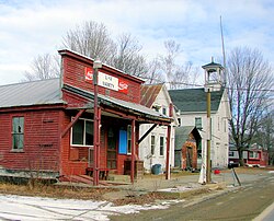
N Chesterville ME.JPG
North Chesterville, 2012
USA Maine location map.svg
Red pog.svg
Chesterville
Usa edcp location map.svg
Red pog.svg
Chesterville
Coordinates: 44°33′3″N70°5′8″W / 44.55083°N 70.08556°W / 44.55083; -70.08556
Country United States
State Maine
County Franklin
VillagesChesterville
North Chesterville
Farmington Falls  (part)
Area
[1]
  Total37.55 sq mi (97.25 km2)
  Land36.17 sq mi (93.68 km2)
  Water1.38 sq mi (3.57 km2)
Elevation
377 ft (115 m)
Population
 (2020)
  Total1,328
  Density37/sq mi (14.2/km2)
Time zone UTC-5 (Eastern (EST))
  Summer (DST) UTC-4 (EDT)
ZIP code
04938
Area code 207
FIPS code 23-12595
GNIS feature ID0582409
Website www.townofchesterville.me

Chesterville is a town in Franklin County, Maine, United States. The population was 1,328 at the 2020 census. [2]

Contents

Geography

According to the United States Census Bureau, the town has a total area of 37.55 square miles (97.25 km2), of which 36.17 square miles (93.68 km2) is land and 1.38 square miles (3.57 km2) is water. [1]

Demographics

Historical population
CensusPop.Note
1810 430
1830 923
1840 1,09819.0%
1850 1,1424.0%
1860 1,110−2.8%
1870 1,011−8.9%
1880 955−5.5%
1890 770−19.4%
1900 709−7.9%
1910 627−11.6%
1920 586−6.5%
1930 575−1.9%
1940 538−6.4%
1950 5889.3%
1960 505−14.1%
1970 64327.3%
1980 86935.1%
1990 1,01216.5%
2000 1,17015.6%
2010 1,35215.6%
2020 1,328−1.8%
U.S. Decennial Census [3]

2010 census

At the 2010 census there were 1,352 people, 549 households, and 392 families living in the town. The population density was 37.4 inhabitants per square mile (14.4/km2). There were 779 housing units at an average density of 21.5 per square mile (8.3/km2). The racial makeup of the town was 97.3% White, 0.1% African American, 0.2% Native American, 0.6% Asian, 0.1% from other races, and 1.8% from two or more races. Hispanic or Latino of any race were 0.4%. [4]

Of the 549 households 29.1% had children under the age of 18 living with them, 57.2% were married couples living together, 10.4% had a female householder with no husband present, 3.8% had a male householder with no wife present, and 28.6% were non-families. 22.8% of households were one person and 7.8% were one person aged 65 or older. The average household size was 2.46 and the average family size was 2.81.

The median age in the town was 44.1 years. 20.1% of residents were under the age of 18; 7.4% were between the ages of 18 and 24; 24% were from 25 to 44; 34.3% were from 45 to 64; and 14.3% were 65 or older. The gender makeup of the town was 49.4% male and 50.6% female.

2000 census

At the 2000 census there were 1,170 people, 467 households, and 324 families living in the town. The population density was 32.1 inhabitants per square mile (12.4/km2). There were 684 housing units at an average density of 18.8 per square mile (7.2/km2). The racial makeup of the town was 98.46% White, 1.20% Asian, 0.09% from other races, and 0.26% from two or more races. Hispanic or Latino of any race were 0.51%. [5]

Of the 467 households 33.8% had children under the age of 18 living with them, 56.5% were married couples living together, 7.5% had a female householder with no husband present, and 30.6% were non-families. 22.1% of households were one person and 7.7% were one person aged 65 or older. The average household size was 2.50 and the average family size was 2.94.

The age distribution was 25.0% under the age of 18, 7.6% from 18 to 24, 29.1% from 25 to 44, 27.3% from 45 to 64, and 10.9% 65 or older. The median age was 38 years. For every 100 females, there were 95.7 males. For every 100 females age 18 and over, there were 97.1 males.

The median household income was $31,563 and the median family income was $35,938. Males had a median income of $29,615 versus $20,592 for females. The per capita income for the town was $15,376. About 10.0% of families and 12.7% of the population were below the poverty line, including 10.7% of those under age 18 and 15.2% of those age 65 or over.
Notable person

Related Research Articles

<span class="mw-page-title-main">Sipsey, Alabama</span> Town in Alabama, United States

Sipsey is a town in Walker County, Alabama, United States. At the 2010 census the population was 437, down from 552.

<span class="mw-page-title-main">New Allakaket, Alaska</span> CDP in Alaska, United States

New Allakaket was a census-designated place (CDP) in Yukon-Koyukuk Census Area, Alaska, United States. The population was 66 at the 2010 census, up from 36 in 2000. In March 2015, neighboring Allakaket annexed New Allakaket.

<span class="mw-page-title-main">Oakfield, Maine</span> Town in the state of Maine, United States

Oakfield is a town in Aroostook County, Maine, United States. The population was 661 at the 2020 census. The village of Oakfield, listed as a census-designated place, is in the northwestern corner of the town.

<span class="mw-page-title-main">Stockholm, Maine</span> Town in the state of Maine, United States

Stockholm is a town in Aroostook County, Maine, United States. The population was 250 at the 2020 census.

Orland is a town in Hancock County, Maine, United States. The population was 2,221 at the 2020 census.

Otis is a town in Hancock County, Maine, United States. The population was 673 at the 2020 census.

<span class="mw-page-title-main">Hartford, Maine</span> Town in the state of Maine, United States

Hartford is a town in Oxford County, Maine, United States. Hartford is included in the Lewiston-Auburn, Maine metropolitan New England City and Town Area. The population was 1,203 at the 2020 census.

Bradley is a town in Penobscot County, Maine, United States. It is part of the Bangor Metropolitan Statistical Area. The population was 1,532 at the 2020 census. The village of Bradley is in the northwestern corner of the town.

Winn is a town in Penobscot County, Maine, United States, on the east bank of the Penobscot River. The town was named for John M. Winn, an early landholder. The population was 399 at the 2020 census.

<span class="mw-page-title-main">Abbot, Maine</span> Town in the state of Maine, United States

Abbot is a town in Piscataquis County, Maine, United States. The population was 650 at the 2020 census. It was named for the treasurer of Bowdoin College, John Abbot.

Detroit is a town in Somerset County, Maine, United States. The population was 885 at the 2020 census.

<span class="mw-page-title-main">Starks, Maine</span> Town in the state of Maine, United States

Starks is a town in Somerset County, Maine, United States. The town was named after General John Stark of the Revolutionary War. The population was 593 at the 2020 census.

<span class="mw-page-title-main">Brooks, Maine</span> Town in the state of Maine, United States

Brooks is a town in Waldo County, Maine, United States. The population was 1,010 at the 2020 census.

<span class="mw-page-title-main">Burnham, Maine</span> Town in the state of Maine, United States

Burnham is a town in Waldo County, Maine, United States. The population was 1,096 at the 2020 census.

<span class="mw-page-title-main">El Rancho, New Mexico</span> Census-designated place in New Mexico, United States

El Rancho is a census-designated place (CDP) in Santa Fe County, New Mexico, United States. It is part of the Santa Fe, New Mexico Metropolitan Statistical Area. The population was 1,199 at the 2010 census.

<span class="mw-page-title-main">Chesterville, Ohio</span> Village in Ohio, United States

Chesterville is a village in Morrow County, Ohio, United States, along the Kokosing River. The population was 191 at the 2020 census. Chesterville is southeast of Mount Gilead, the county seat.

<span class="mw-page-title-main">Elk Township, Chester County, Pennsylvania</span> Township in Pennsylvania, United States

Elk Township is a township in Chester County, Pennsylvania, United States. The population was 1,681 at the 2010 census.

<span class="mw-page-title-main">Hartstown, Pennsylvania</span> Census-designated place in Pennsylvania, United States

Hartstown is a census-designated place (CDP) in Crawford County, Pennsylvania, United States. The population was 201 at the 2010 census, down from 246 in 2000.

<span class="mw-page-title-main">Sandy Creek (village), New York</span> Village in New York, United States

Sandy Creek is a village in Oswego County, New York, United States. The population was 771 at the 2010 census.

<span class="mw-page-title-main">Dane (town), Wisconsin</span>

Dane is a town in Dane County, Wisconsin, United States. The population was 968 at the 2000 census. The unincorporated community of Lutheran Hill is located partially in the town.

References

  1. 1 2 "US Gazetteer files 2010". United States Census Bureau . Retrieved December 16, 2012.
  2. "Census - Geography Profile: Chesterville town, Franklin County, Maine" . Retrieved January 20, 2022.
  3. "Census of Population and Housing". Census.gov. Retrieved June 4, 2015.
  4. "U.S. Census website". United States Census Bureau . Retrieved December 16, 2012.
  5. "U.S. Census website". United States Census Bureau . Retrieved January 31, 2008.

44°33′04″N70°05′10″W / 44.55111°N 70.08611°W / 44.55111; -70.08611