New Hampshire is a state in the New England region of the Northeastern United States. It is bordered by Massachusetts to the south, Vermont to the west, Maine and the Gulf of Maine to the east, and the Canadian province of Quebec to the north. Of the 50 U.S. states, New Hampshire is the fifth smallest by area and the tenth least populous, with slightly more than 1.3 million residents as of the 2020 census. Concord is the state capital, while Manchester is the largest city. New Hampshire's motto, "Live Free or Die", reflects its role in the American Revolutionary War; its nickname, "The Granite State", refers to its extensive granite formations and quarries. It is well known nationwide for holding the first primary in the U.S. presidential election cycle, and for its resulting influence on American electoral politics.

Albany is a town in Carroll County, New Hampshire, United States. The population was 759 at the 2020 census.

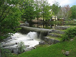
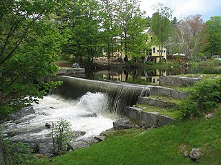
Tamworth is a town in Carroll County, New Hampshire, United States. The population was 2,812 at the 2020 census. Tamworth includes the villages of Chocorua, South Tamworth, Wonalancet, and Whittier. The White Mountain National Forest is to the north. The town is home to Hemenway State Forest in the north and White Lake State Park in the southeast.

Lake Winnipesaukee is the largest lake in the U.S. state of New Hampshire, located in the Lakes Region at the foothills of the White Mountains. It is approximately 21 miles (34 km) long (northwest-southeast) and from 1 to 9 miles wide (northeast-southwest), covering 69 square miles (179 km2)—71 square miles (184 km2) when Paugus Bay is included—with a maximum depth of 180 feet (55 m). The center area of the lake is called The Broads.
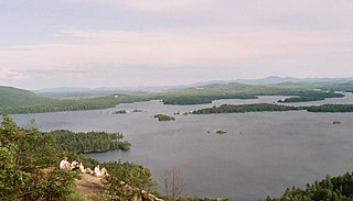
Squam Lake is a lake located in the Lakes Region of central New Hampshire, United States, south of the White Mountains, straddling the borders of Grafton, Carroll, and Belknap counties. The largest town center on the lake is Holderness. The lake is located northwest of much larger Lake Winnipesaukee.

New Hampshire Route 16 is a 154.771-mile (249.080 km), north–south state highway in New Hampshire, United States, the main road connecting the Seacoast region to the Lakes Region and the White Mountains. Much of its length is close to the border with Maine. The section from Portsmouth to Milton is a controlled-access toll highway known as the Spaulding Turnpike. Between Milton and Chocorua, and between Conway and Glen, it is known as the White Mountain Highway. It is known as Chocorua Mountain Highway between Chocorua and Conway and various other local names before crossing into Maine about 20 miles (32 km) south of the Canadian border. Portions of NH 16 run concurrent with U.S. Route 4 (US 4), US 202, NH 25, and US 302, and US 2.

William Trost Richards was an American landscape artist. He was associated with both the Hudson River School and the American Pre-Raphaelite movement.
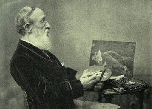
Benjamin Champney was a painter known for his role in White Mountain art of the 19th century. He began his training as a lithographer under celebrated marine artist Fitz Henry Lane at Pendleton's Lithography shop in Boston. Most art historians consider him the founder of the "North Conway Colony" of painters who came to North Conway, New Hampshire, and the surrounding area during the second half of the 19th century. His paintings were often used to make chromolithographs that were subsequently sold to tourists who could not afford Champney's originals. He exhibited regularly at the Boston Athenæum and was a founder of the Boston Art Club.

White Mountain art is the body of work created during the 19th century by over four hundred artists who painted landscape scenes of the White Mountains of New Hampshire in order to promote the region and, consequently, sell their works of art.

Mount Chocorua is a 3,490 ft (1,060 m) mountain in the White Mountains of New Hampshire, the easternmost peak of the Sandwich Range. Although the mountain is not outstanding for its elevation, it is very rugged and has excellent views of the surrounding lakes, mountains, and forests. Being at the end of the range, its bare summit can be seen from almost every direction and identified from many points throughout central New Hampshire and western Maine, and it has been the subject of numerous works of art. Many hiking trails ascend the mountain. Scenic Chocorua Lake lies directly to the south.
The Swift River is an 8.3-mile-long (13.4 km) river located in eastern New Hampshire in the United States. It is a tributary of the Bearcamp River, part of the Ossipee Lake / Saco River watershed leading to the Atlantic Ocean. The Swift River is located only four miles south of the larger and longer Swift River which parallels the Kancamagus Highway in the White Mountain National Forest.
The Chocorua River is a 15.2-mile (24.5 km) river located in eastern New Hampshire in the United States. It is a tributary of the Bearcamp River, part of the Ossipee Lake / Saco River watershed leading to the Atlantic Ocean.

The Sandwich Range is located in the White Mountains of New Hampshire in the United States, north of the Lakes Region and south of the Kancamagus Highway. Although the range is not outstanding for its elevation, it is very rugged and has excellent views of the surrounding lakes, mountains, and forests.
Chocorua may refer to a place name in the White Mountains of New Hampshire, United States:

Chocorua Lake is a picturesque lake in northeast New Hampshire with commanding views of the summit of Mount Chocorua. It is approximately 1.1 miles (1.8 km) long (north-south) with a maximum width of 3,500 feet (1.1 km) (east-west), covering 222 acres (90 ha), and a maximum depth of 27 feet (8.2 m).
Ferncroft is an unincorporated community lying mostly in the town of Albany in Carroll County, New Hampshire, United States. Some of the roads and houses in Ferncroft stretch into the towns of Sandwich and Waterville Valley. The hamlet is a widely spaced cluster of houses centered on several fields lying along the Wonalancet River on Ferncroft Road.
The Chocorua Lake Basin Historic District is a large historic district surrounding Chocorua Lake in the town of Tamworth, New Hampshire. It includes more than 6,000 acres (2,400 ha), with the lake roughly at its center, extending from Washington Hill Road in the east to Fowles Mill Road and Philbrick Neighborhood Road in the west, and from the town line with Albany in the north to Heavenly Hill Road in the south. The district's significance derives from a large cluster of late 19th and early 20th century summer resort houses built around and near the lake, and the role the area's landowners have played in the conservation of the lake and viewsheds associated with it and nearby Mount Chocorua. The district was listed on the National Register of Historic Places in 2005.

Camp Mowglis is a nonprofit residential camp founded in 1903 and is one of the oldest summer camps in the United States. It is located in East Hebron, New Hampshire, on the shores of Newfound Lake, and owned by the nonprofit Holt Elwell Memorial Foundation. Mowglis was created with encouragement from author Rudyard Kipling and incorporates themes from his Jungle Books. The campgrounds were listed on the National Register of Historic Places in 2019.
The Chocorua Island Chapel is a non-denominational chapel located on the island of the same name on Squam Lake in Grafton County, New Hampshire, in the town of Holderness. It is an open-air place of worship, created as an extension of Camp Chocorua, the first summer youth camp in the United States. The open-air chapel was created by the camp's first season of young boys, made entirely of boulders, trees, various island vegetation, and beach sand.

Mount Wonalancet is a 2,760 ft (840 m) mountain in the town of Waterville Valley, New Hampshire, overlooking the unincorporated communities of Wonalancet and Ferncroft. It is named after Wonalancet, a 17th-century sachem of the Pennacook, a Native American people. Mount Wonalancet lies in Grafton County, immediately west of the Carroll County border, the county in which Ferncroft and Wonalancet are located.