Center Sandwich, New Hampshire

Last updated

Center Sandwich, New Hampshire
Sandwich Town Hall Ctr Sandwich NH 2023.jpg
USA New Hampshire location map.svg
Red pog.svg
Center Sandwich
Usa edcp location map.svg
Red pog.svg
Center Sandwich
Coordinates: 43°48′26″N71°26′24″W / 43.80722°N 71.44000°W / 43.80722; -71.44000
Country United States
State New Hampshire
County Carroll
Town Sandwich
Area
[1]
  Total0.59 sq mi (1.53 km2)
  Land0.59 sq mi (1.53 km2)
  Water0.00 sq mi (0.00 km2)
Elevation
654 ft (199 m)
Population
 (2020)
  Total156
  Density264.41/sq mi (102.01/km2)
Time zone UTC-5 (Eastern (EST))
  Summer (DST) UTC-4 (EDT)
ZIP code
03227
Area code 603
FIPS code 33-10900
GNIS feature ID0871655

Center Sandwich is a census-designated place in the town of Sandwich in Carroll County, New Hampshire, in the United States. It is the primary settlement in the town and had a population of 156 at the 2020 census. [2] The village center and surrounding area are listed on the National Register of Historic Places as the Center Sandwich Historic District.

Contents

The village is home of the Sandwich Fair, held annually in early October.

History

Center Sandwich began as the site of an early gristmill, erected in 1768 by Daniel Beede, which was followed in 1780 by a sawmill, both on the banks of the Red Hill River. Roads were then built to the area, and the village and surrounding rural parts of town grew from about 900 people in 1790 to over 2,000 in 1820. Most of the village's development and growth occurred in the years before the Civil War, resulting in residential and civic buildings that are largely vernacular Federal and Greek Revival in style. Because no railroads were built to serve the area, Center Sandwich declined in importance after the Civil War. Only a small number of changes occurred in the village in the 20th century. The oldest surviving building in the village is the 1792 Baptist church, originally Federal in style, but later given Greek Revival features. [3]

Geography

The CDP is in the south-central part of the town of Sandwich, at the intersection of New Hampshire Route 113 and Route 109. Route 113 leads southwest along the north side of Squam Lake 11 miles (18 km) to Holderness and leads east 13 miles (21 km) to Tamworth. Route 109 begins in Center Sandwich and travels southeast 4.5 miles (7.2 km) to Moultonborough and 22 miles (35 km) to Wolfeboro.

According to the U.S. Census Bureau, the Center Sandwich CDP has a total area of 0.58 square miles (1.5 km2), of which 1,473 square metres (0.364 acres), or 0.1%, are water. [4] The eastern edge of the CDP follows the Red Hill River, a south-flowing tributary of Lake Winnipesaukee.

Demographics

Historical population
CensusPop.Note
2010 123
2020 15626.8%
U.S. Decennial Census [5]

As of the census of 2010, there were 123 people, 63 households, and 33 families residing in the CDP. There were 89 housing units, of which 26, or 29.2%, were vacant. 15 of the vacant units were for seasonal or recreational use. The racial makeup of the CDP was 97.6% white, 0.8% Native American, and 1.6% from two or more races. None of the population were Hispanic or Latino of any race. [6]

Of the 63 households in the CDP, 17.5% had children under the age of 18 living with them, 39.7% were headed by married couples living together, 11.1% had a female householder with no husband present, and 47.6% were non-families. 39.7% of all households were made up of individuals, and 30.2% were someone living alone who was 65 years of age or older. The average household size was 1.95, and the average family size was 2.67. [6]

16.3% of residents in the CDP were under the age of 18, 2.4% were from age 18 to 24, 15.4% were from 25 to 44, 34.9% were from 45 to 64, and 30.9% were 65 years of age or older. The median age was 54.8 years. For every 100 females, there were 70.8 males. For every 100 females age 18 and over, there were 58.5 males. [6]

For the period 2011-15, the estimated median annual income for a household was $39,737, and the per capita income for the CDP was $20,130. [7]

See also

Related Research Articles

<span class="mw-page-title-main">Suncook, New Hampshire</span> Census-designated place in New Hampshire, United States

Suncook is a census-designated place (CDP) in Merrimack County, New Hampshire, United States. The population was 5,501 at the 2020 census. Approximately two-thirds of Suncook is located in the town of Pembroke, with the remainder in Allenstown.

<span class="mw-page-title-main">Meredith (CDP), New Hampshire</span> Census-designated place in New Hampshire, United States

Meredith is a census-designated place (CDP) and the main village in the town of Meredith in Belknap County, New Hampshire, United States. The population was 2,527 at the 2020 census, out of 6,662 in the entire town of Meredith.

<span class="mw-page-title-main">Conway (CDP), New Hampshire</span> Census-designated place in New Hampshire, United States

Conway is a census-designated place (CDP) and the primary village in the town of Conway in Carroll County, New Hampshire, United States. The population was 3,576 at the 2020 census. It is the most populous community in the town of Conway, ahead of North Conway.

<span class="mw-page-title-main">Wolfeboro (CDP), New Hampshire</span> Census-designated place in New Hampshire, United States

Wolfeboro is a census-designated place (CDP) in the town of Wolfeboro in Carroll County, New Hampshire, United States. It consists of the main village of Wolfeboro within the town, as well as the smaller village of Wolfeboro Falls. The population of the CDP was 3,300 at the 2020 census, out of 6,416 in the entire town of Wolfeboro.

<span class="mw-page-title-main">Bristol (CDP), New Hampshire</span> Census-designated place in New Hampshire, United States

Bristol is a census-designated place (CDP) and the main village in the town of Bristol in Grafton County, New Hampshire, United States. The population of the CDP was 1,911 at the 2020 census, out of 3,244 in the entire town.

<span class="mw-page-title-main">Greenville (CDP), New Hampshire</span> Census-designated place in New Hampshire, United States

Greenville is a census-designated place (CDP) and the main village in the town of Greenville in Hillsborough County, New Hampshire, United States. The population of the CDP was 1,074 at the 2020 census, out of 1,974 in the entire town.

<span class="mw-page-title-main">Hooksett (CDP), New Hampshire</span> Census-designated place in New Hampshire, United States

Hooksett is a census-designated place (CDP) in the town of Hooksett in Merrimack County, New Hampshire, United States. The CDP includes the historic central village of Hooksett as well as suburban and rural land surrounding it. The population of the CDP was 5,283 at the 2020 census, out of 14,871 in the entire town.

<span class="mw-page-title-main">Pittsfield (CDP), New Hampshire</span> Census-designated place in New Hampshire, United States

Pittsfield is a census-designated place (CDP) and the main village in the town of Pittsfield in Merrimack County, New Hampshire, United States. The population of the CDP was 1,570 at the 2020 census, out of 4,075 in the entire town.

<span class="mw-page-title-main">Derry (CDP), New Hampshire</span> Census-designated place in New Hampshire, United States

Derry is a census-designated place (CDP) in the town of Derry in Rockingham County, New Hampshire, United States. The CDP comprises the urban center of the town, as well as the village of East Derry and connected suburban areas. The population of the CDP was 22,879 at the 2020 census, out of 34,317 in the entire town.

<span class="mw-page-title-main">Londonderry (CDP), New Hampshire</span> Census-designated place in New Hampshire, United States

Londonderry is a census-designated place (CDP) within the town of Londonderry in Rockingham County, New Hampshire, United States. The population of the CDP was 11,645 at the 2020 census, out of 25,826 in the entire town.

<span class="mw-page-title-main">Newmarket (CDP), New Hampshire</span> Census-designated place in New Hampshire, United States

Newmarket is a census-designated place (CDP) and the main village in the town of Newmarket in Rockingham County, New Hampshire, United States. The population of the CDP was 5,797 at the 2020 census, out of 9,430 in the entire town.

<span class="mw-page-title-main">Melvin Village, New Hampshire</span> Census-designated place in New Hampshire, United States

Melvin Village is a census-designated place (CDP) within the town of Tuftonboro in Carroll County, New Hampshire, United States. Its population at the 2020 census was 273. The village is a summer vacation spot on Melvin Bay of Lake Winnipesaukee.

<span class="mw-page-title-main">Sanbornville, New Hampshire</span> Census-designated place in New Hampshire, United States

Sanbornville is a census-designated place (CDP) and the primary village in the town of Wakefield, Carroll County, New Hampshire, United States. It had a population of 963 at the 2020 census.

<span class="mw-page-title-main">North Woodstock, New Hampshire</span> Census-designated place in New Hampshire, United States

North Woodstock is a census-designated place (CDP) and the primary village in the town of Woodstock in Grafton County, New Hampshire, United States. It had a population of 739 at the 2020 census.

Center Ossipee is a census-designated place in the town of Ossipee in Carroll County, New Hampshire. The population was 526 at the 2020 census. It is one of the two main villages in the town, the other being Ossipee Corner. Center Ossipee has a separate ZIP code (03814) from other portions of the town of Ossipee.

<span class="mw-page-title-main">Bartlett (CDP), New Hampshire</span> Census-designated place in New Hampshire, United States

Bartlett is a census-designated place (CDP) and the main village in the town of Bartlett in Carroll County, New Hampshire, United States. The population was 351 at the 2020 census, out of 3,200 in the entire town of Bartlett.

<span class="mw-page-title-main">Newfields (CDP), New Hampshire</span> Census-designated place in New Hampshire, United States

Newfields is a census-designated place (CDP) and the main village within the town of Newfields, Rockingham County, New Hampshire, United States. The population of the CDP was 378 at the 2020 census, out of 1,769 in the entire town.

Suissevale is a private subdivision in the town of Moultonborough in Carroll County, New Hampshire, United States. It is located between New Hampshire Route 109 and Moultonborough Bay, an arm of Lake Winnipesaukee. The subdivision is listed as a census-designated place (CDP) and had a year-round population of 328 as of the 2020 census.

<span class="mw-page-title-main">Amherst (CDP), New Hampshire</span> Census-designated place in New Hampshire, United States

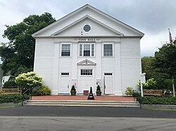
Amherst is a census-designated place (CDP) and the main village in the town of Amherst in Hillsborough County, New Hampshire, United States. The population of the CDP was 697 at the 2020 census, out of 11,753 in the entire town. The village center is listed on the National Register of Historic Places as the Amherst Village Historic District.

Bethlehem is a census-designated place (CDP) and the main village in the town of Bethlehem in Grafton County, New Hampshire, United States. The population of the CDP was 826 at the 2020 census, out of 2,484 in the entire town.

References

Town Hall, 1940 Town Hall, Center Sandwich, NH.jpg
Town Hall, 1940
  1. "ArcGIS REST Services Directory". United States Census Bureau. Retrieved September 20, 2022.
  2. "Center Sandwich CDP, New Hampshire: 2020 DEC Redistricting Data (PL 94-171)". U.S. Census Bureau. Retrieved November 2, 2021.
  3. "NRHP nomination for Center Sandwich Historic District". National Park Service. Retrieved May 3, 2014.
  4. "2021 U.S. Gazetteer Files – New Hampshire". United States Census Bureau. Retrieved November 2, 2021.
  5. "Decennial Census Official Publications". Census.gov. Retrieved March 4, 2024.
  6. 1 2 3 "Profile of General Population and Housing Characteristics: 2010 Census Summary File 1 (DP-1): Center Sandwich CDP, New Hampshire". American Factfinder. U.S. Census Bureau. Archived from the original on February 13, 2020. Retrieved October 12, 2017.
  7. "Selected Economic Characteristics: 2011-2015 American Community Survey 5-Year Estimates (DP03): Center Sandwich CDP, New Hampshire". American Factfinder. U.S. Census Bureau. Archived from the original on February 13, 2020. Retrieved October 12, 2017.