Bartlett (CDP), New Hampshire

Last updated

Bartlett, New Hampshire
BartlettCDPNotchTrain.jpg
The Notch Train of the Conway Scenic Railroad approaching Bartlett freight house, August 2019
USA New Hampshire location map.svg
Red pog.svg
Bartlett
Usa edcp location map.svg
Red pog.svg
Bartlett
North America laea location map.svg
Red pog.svg
Bartlett
Coordinates: 44°4′40″N71°16′55″W / 44.07778°N 71.28194°W / 44.07778; -71.28194
Country United States
State New Hampshire
County Carroll
Town Bartlett
Area
[1]
  Total1.51 sq mi (3.92 km2)
  Land1.49 sq mi (3.85 km2)
  Water0.02 sq mi (0.06 km2)
Elevation
671 ft (205 m)
Population
 (2020)
  Total351
  Density235.89/sq mi (91.06/km2)
Time zone UTC-5 (Eastern (EST))
  Summer (DST) UTC-4 (EDT)
ZIP code
03812
Area code 603
FIPS code 33-03620
GNIS feature ID2629712

Bartlett is a census-designated place (CDP) and the main village in the town of Bartlett in Carroll County, New Hampshire, United States. The population was 351 at the 2020 census, [2] out of 3,200 in the entire town of Bartlett.

Contents

Geography

The CDP is in the western part of the town of Bartlett, at the junction of U.S. Route 302 with Bear Notch Road. US 302 leads east and south 11 miles (18 km) to North Conway and northwest through Crawford Notch in the White Mountains 36 miles (58 km) to Littleton. Bear Notch Road leads south 9 miles (14 km) across Bear Notch to New Hampshire Route 112 (the Kancamagus Highway) in Albany.

The Bartlett CDP is bordered to the north by the Saco River, to the west by an unnamed brook east of Albany Brook, to the south by the White Mountain National Forest, and to the east by an unnamed brook that flows down the west side of Big Attitash Mountain, separating the CDP from residential development connected to the Attitash Mountain Resort. [3]

According to the U.S. Census Bureau, the Bartlett CDP has a total area of 1.5 square miles (3.9 km2), of which 0.02 square miles (0.06 km2), or 1.57%, are water. [4]

Demographics

Historical population
CensusPop.Note
2010 373
2020 351−5.9%
U.S. Decennial Census [5]

As of the census of 2010, there were 373 people, 166 households, and 95 families residing in the CDP. There were 229 housing units, of which 63, or 27.5%, were vacant. 44 of the vacant units were seasonal or vacation properties. The racial makeup of the CDP was 96.5% white, 0.5% African American, and 2.9% from two or more races. 1.1% of the population were Hispanic or Latino of any race. [6]

Of the 166 households in the CDP, 28.9% had children under the age of 18 living with them, 40.4% were headed by married couples living together, 13.9% had a female householder with no husband present, and 42.8% were non-families. 31.3% of all households were made up of individuals, and 10.8% were someone living alone who was 65 years of age or older. The average household size was 2.25, and the average family size was 2.79. [6]

20.6% of residents in the CDP were under the age of 18, 6.6% were from age 18 to 24, 21.6% were from 25 to 44, 36.5% were from 45 to 64, and 15.0% were 65 years of age or older. The median age was 41.5 years. For every 100 females, there were 95.3 males. For every 100 females age 18 and over, there were 89.7 males. [6]

For the period 2011-15, the estimated median annual income for a household was $33,063, and per capita income for the CDP was $21,106. [7]

Related Research Articles

<span class="mw-page-title-main">Bartlett, New Hampshire</span> Town in New Hampshire, United States

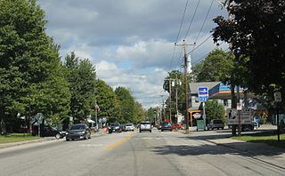
Bartlett is a town in Carroll County, New Hampshire, United States. The population was 3,200 at the 2020 census, up from 2,788 at the 2010 census. Bartlett includes the unincorporated community of Glen as well as portions of the communities of Kearsarge and Intervale, which the town shares with the neighboring town of Conway. It is set in the White Mountains and is surrounded by the White Mountain National Forest. It is home to the Attitash Mountain Resort and the Story Land theme park.

<span class="mw-page-title-main">Meredith (CDP), New Hampshire</span> Census-designated place in New Hampshire, United States

Meredith is a census-designated place (CDP) and the main village in the town of Meredith in Belknap County, New Hampshire, United States. The population was 2,527 at the 2020 census, out of 6,662 in the entire town of Meredith.

<span class="mw-page-title-main">Conway (CDP), New Hampshire</span> Census-designated place in New Hampshire, United States

Conway is a census-designated place (CDP) and the primary village in the town of Conway in Carroll County, New Hampshire, United States. The population was 3,576 at the 2020 census. It is the most populous community in the town of Conway, ahead of North Conway.

<span class="mw-page-title-main">Wolfeboro (CDP), New Hampshire</span> Census-designated place in New Hampshire, United States

Wolfeboro is a census-designated place (CDP) in the town of Wolfeboro in Carroll County, New Hampshire, United States. It consists of the main village of Wolfeboro within the town, as well as the smaller village of Wolfeboro Falls. The population of the CDP was 3,300 at the 2020 census, out of 6,416 in the entire town of Wolfeboro.

Gorham is a census-designated place (CDP) and the main village in the town of Gorham in Coos County, New Hampshire, United States. The population of the CDP was 1,851 at the 2020 census, out of 2,698 people in the entire town of Gorham.

Hanover is a census-designated place (CDP) and the main village in the town of Hanover in Grafton County, New Hampshire, United States. The population of the CDP was 9,078 at the 2020 census, out of 11,870 in the entire town. The CDP includes the campus of Dartmouth College.

Lisbon is a census-designated place (CDP) and the main village in the town of Lisbon in Grafton County, New Hampshire, United States. The population of the CDP was 965 at the 2020 census, out of 1,621 in the entire town.

Littleton is a census-designated place (CDP) and the main village in the town of Littleton in Grafton County, New Hampshire, United States. The population of the CDP was 4,467 at the 2020 census, out of 6,005 in the entire town.

<span class="mw-page-title-main">Plymouth (CDP), New Hampshire</span> Census-designated place in New Hampshire, United States

Plymouth is a census-designated place (CDP) and the main village in the town of Plymouth in Grafton County, New Hampshire, United States. Its population was 4,730 at the 2020 census, out of 6,682 in the entire town. The CDP includes the campus of Plymouth State University.

<span class="mw-page-title-main">Newport (CDP), New Hampshire</span> Census-designated place in New Hampshire, United States

Newport is a census-designated place (CDP) comprising the main village and surrounding rural land in the town of Newport, Sullivan County, New Hampshire, United States. The population of the CDP was 4,735 at the 2020 census, out of 6,299 in the entire town.

<span class="mw-page-title-main">North Woodstock, New Hampshire</span> Census-designated place in New Hampshire, United States

North Woodstock is a census-designated place (CDP) and the primary village in the town of Woodstock in Grafton County, New Hampshire, United States. It had a population of 739 at the 2020 census.

<span class="mw-page-title-main">Belmont (CDP), New Hampshire</span> Census-designated place in New Hampshire, United States

Belmont is a census-designated place (CDP) and the main village in the town of Belmont in Belknap County, New Hampshire, United States. The population was 1,285 at the 2020 census, out of 7,314 in the entire town of Belmont.

<span class="mw-page-title-main">Newfields (CDP), New Hampshire</span> Census-designated place in New Hampshire, United States

Newfields is a census-designated place (CDP) and the main village within the town of Newfields, Rockingham County, New Hampshire, United States. The population of the CDP was 378 at the 2020 census, out of 1,769 in the entire town.

New Hampton is a census-designated place (CDP) and the main village in the town of New Hampton in Belknap County, New Hampshire, United States. The population was 373 at the 2020 census, out of 2,377 people in the entire town of New Hampton.

<span class="mw-page-title-main">Bennington (CDP), New Hampshire</span> Census-designated place in New Hampshire, United States

Bennington is a census-designated place (CDP) and the main village in the town of Bennington in Hillsborough County, New Hampshire, United States. The population of the CDP was 338 at the 2020 census, out of 1,501 in the entire town.

Bethlehem is a census-designated place (CDP) and the main village in the town of Bethlehem in Grafton County, New Hampshire, United States. The population of the CDP was 826 at the 2020 census, out of 2,484 in the entire town.

Lincoln is a census-designated place (CDP) and the main village in the town of Lincoln in Grafton County, New Hampshire, United States. The population of the CDP was 969 at the 2020 census, out of 1,631 in the entire town.

Mountain Lakes is a census-designated place (CDP) in the towns of Haverhill and Bath in Grafton County, New Hampshire, United States. It had a population of 504 at the 2020 census.

<span class="mw-page-title-main">Troy (CDP), New Hampshire</span> Census-designated place in New Hampshire, United States

Troy is a census-designated place (CDP) and the main village in the town of Troy in Cheshire County, New Hampshire, United States. The population of the CDP was 1,108 at the 2020 census, compared to 2,130 in the entire town. The center of the CDP is the Troy Village Historic District.

<span class="mw-page-title-main">Walpole (CDP), New Hampshire</span> Census-designated place in New Hampshire, United States

Walpole is a census-designated place (CDP) and the central village in the town of Walpole in Cheshire County, New Hampshire, United States. The population of the CDP was 573 at the 2020 census, compared to 3,633 in the entire town.

References

  1. "ArcGIS REST Services Directory". United States Census Bureau. Retrieved September 20, 2022.
  2. "Bartlett CDP, New Hampshire: 2020 DEC Redistricting Data (PL 94-171)". U.S. Census Bureau. Retrieved November 2, 2021.
  3. "TIGERweb: Bartlett CDP, New Hampshire". Geography Division, U.S. Census Bureau. Retrieved August 25, 2017.
  4. "2021 U.S. Gazetteer Files – New Hampshire". United States Census Bureau. Retrieved November 2, 2021.
  5. "Decennial Census Official Publications". Census.gov. Retrieved March 4, 2024.
  6. 1 2 3 "Profile of General Population and Housing Characteristics: 2010 Census Summary File 1 (DP-1): Bartlett CDP, New Hampshire". American Factfinder. U.S. Census Bureau. Archived from the original on February 13, 2020. Retrieved October 11, 2017.
  7. "Selected Economic Characteristics: 2011-2015 American Community Survey 5-Year Estimates (DP03): Bartlett CDP, New Hampshire". American Factfinder. U.S. Census Bureau. Archived from the original on February 13, 2020. Retrieved October 11, 2017.