North Conway, New Hampshire

Last updated

North Conway, New Hampshire
North Conway Main Street 5.JPG
Buildings in downtown North Conway
USA New Hampshire location map.svg
Red pog.svg
North Conway
Usa edcp location map.svg
Red pog.svg
North Conway
Coordinates: 44°3′11″N71°7′41″W / 44.05306°N 71.12806°W / 44.05306; -71.12806
Country United States
State New Hampshire
County Carroll
Town Conway
Area
[1]
  Total6.96 sq mi (18.02 km2)
  Land6.82 sq mi (17.65 km2)
  Water0.14 sq mi (0.37 km2)
Elevation
525 ft (160 m)
Population
 (2020)
  Total2,116
  Density310.49/sq mi (119.89/km2)
Time zone UTC-5 (Eastern (EST))
  Summer (DST) UTC-4 (EDT)
ZIP codes
03860 (North Conway)
03847 (Kearsarge)
Area code 603
FIPS code 33-53860
GNIS feature ID0872395
Website www.conwaynh.org

North Conway is a census-designated place (CDP) and village in eastern Carroll County, New Hampshire, United States. The population was 2,116 at the 2020 census. [2] A year-round resort area, North Conway is the second-largest village within the town of Conway, after the village of Conway proper. North Conway maintains its own fire station, post office and public library, sharing its other services with Conway. The White Mountain National Forest is to the west and north. The area is home to Cathedral Ledge (popular with climbers), Echo Lake State Park, and Cranmore Mountain Resort. North Conway is known for its large number of outlet shops.

Contents

Aerial view of North Conway and Mount Cranmore North Conway Village, New Hampshire.jpg
Aerial view of North Conway and Mount Cranmore

History

Mount Washington in 1872 Mount Washington, from the Conway Road.jpg
Mount Washington in 1872
Aerial view of North Conway in 1921 New Hampshire - North Conway - NARA - 23942441 (cropped).jpg
Aerial view of North Conway in 1921

Chartered in 1765 by colonial Governor Benning Wentworth, the town is named for Henry Seymour Conway, ambitious son of a prominent English family, who was elected to the House of Commons at age 20, fought at Culloden, and became Secretary of State. Early settlers called the area Pequawket (known colloquially as "Pigwacket"), adopting the name of the Abenaki Indian village which stretched down the Saco River to its stockaded center at Fryeburg, Maine.

North Conway is in the White Mountains, with Mount Washington to the northwest. The rugged terrain became popular in the 19th century with artists. Their paintings were known collectively as White Mountain art, which in turn attracted tourists to the area, particularly after the Portsmouth, Great Falls & Conway Railroad extended service in 1872 to North Conway. In 1874, the line built a Second Empire depot, designed by Nathaniel J. Bradlee. In 1932, "snow trains" began carrying enthusiasts to "the birthplace of American skiing", as North Conway is known.[ citation needed ]

Increasing automobile travel brought the decline of trains. The railroad, then part of the Boston & Maine, abandoned passenger service to the area in 1961 and freight service in 1972. Subsequently, the Conway Scenic Railroad was established. Today, the line offers visitors a tour of the region, including Crawford Notch. The station is listed on the National Register of Historic Places.

In the late 1980s, the White Mountain Airport closed and was redeveloped as a large outlet mall called Settlers' Green Outlet Village. Continued growth through the 1990s and 2000s in North Conway and the villages nearby made Conway the most populous community in Carroll County. Traffic congestion led to an overhaul of the road system, including widening Route 16 through North Conway village and constructing a road parallel to Route 16 to allow traffic to move between Redstone and Intervale uninterrupted. A plan for a bypass of the area was developed but not implemented.

North Conway remains a popular destination due to its shopping, recreation, and attractions.

North Conway station ConwayScenic.jpg
North Conway station

Recreation

Cathedral Ledge in 1914 Echo Lake, North Conway, NH.jpg
Cathedral Ledge in 1914

North Conway and its surrounding towns offer hiking in the White Mountain National Forest. The area is a major rock climbing destination in the northeastern United States, [3] particularly Cathedral Ledge in Echo Lake State Park. The 500-foot (150 m) cliff overlooks Echo Lake and North Conway from the west. Unlike nearby White Horse Ledge, another rock climbing site, Cathedral Ledge has an automobile road to the summit, which provides fine views of the Saco River Valley.

In late September through early October, tourists arrive to see the autumn foliage on the surrounding mountains and forests. The Conway Scenic Railroad features train rides that leave from the village's Victorian station. In the winter, the village is the nighttime destination for skiers visiting the area resorts, including North Conway's own Cranmore Mountain as well as nearby Attitash Mountain Resort, Black Mountain and Wildcat Mountain.

North Conway is home to the Green Hills Preserve. The preserve encompasses several mountains in the Mt. Washington Valley, and is a low north-south running mountain ridge flanking the east side of Route 16. The preserve includes Rattlesnake Mountain, Middle Mountain, Peaked Mountain, and Black Cap mountain. [4] [5] [6] [7]

Geography

North Conway is located at 44°3′6″N71°7′22″W / 44.05167°N 71.12278°W / 44.05167; -71.12278 (44.051534, -71.122752), [8] in the northern part of the town of Conway.

According to the United States Census Bureau, the North Conway census-designated place (CDP) includes the village of North Conway plus the Conway portion of the neighboring community of Kearsarge. The CDP has a total area of 6.9 square miles (18.0 km2), of which 6.8 square miles (17.7 km2) are land and 0.2 square miles (0.4 km2), or 2.04%, are water. [9] The Saco River forms the western edge of the North Conway CDP.

Climate

Climate data for North Conway, New Hampshire (1991–2020 normals, extremes 1959present)
MonthJanFebMarAprMayJunJulAugSepOctNovDecYear
Record high °F (°C)61
(16)
71
(22)
85
(29)
92
(33)
98
(37)
102
(39)
100
(38)
103
(39)
98
(37)
88
(31)
77
(25)
71
(22)
103
(39)
Mean maximum °F (°C)49.4
(9.7)
52.7
(11.5)
61.6
(16.4)
78.6
(25.9)
87.8
(31.0)
91.9
(33.3)
92.3
(33.5)
90.6
(32.6)
86.7
(30.4)
75.7
(24.3)
65.4
(18.6)
52.9
(11.6)
94.9
(34.9)
Mean daily maximum °F (°C)30.0
(−1.1)
33.4
(0.8)
41.7
(5.4)
55.1
(12.8)
67.8
(19.9)
76.2
(24.6)
81.4
(27.4)
79.9
(26.6)
72.3
(22.4)
58.7
(14.8)
46.2
(7.9)
35.6
(2.0)
56.5
(13.6)
Daily mean °F (°C)19.9
(−6.7)
22.3
(−5.4)
31.1
(−0.5)
43.2
(6.2)
55.4
(13.0)
64.6
(18.1)
69.7
(20.9)
67.9
(19.9)
60.0
(15.6)
47.7
(8.7)
36.8
(2.7)
26.6
(−3.0)
45.4
(7.5)
Mean daily minimum °F (°C)9.9
(−12.3)
11.1
(−11.6)
20.4
(−6.4)
31.3
(−0.4)
43.0
(6.1)
53.1
(11.7)
58.0
(14.4)
55.9
(13.3)
47.7
(8.7)
36.6
(2.6)
27.3
(−2.6)
17.7
(−7.9)
34.3
(1.3)
Mean minimum °F (°C)−9.4
(−23.0)
−6.9
(−21.6)
0.2
(−17.7)
20.7
(−6.3)
29.7
(−1.3)
41.1
(5.1)
48.5
(9.2)
45.9
(7.7)
33.5
(0.8)
24.6
(−4.1)
13.2
(−10.4)
0.1
(−17.7)
−12.0
(−24.4)
Record low °F (°C)−34
(−37)
−34
(−37)
−22
(−30)
0
(−18)
18
(−8)
29
(−2)
33
(1)
26
(−3)
20
(−7)
10
(−12)
−4
(−20)
−24
(−31)
−34
(−37)
Average precipitation inches (mm)3.60
(91)
3.18
(81)
3.67
(93)
4.41
(112)
3.68
(93)
4.53
(115)
4.50
(114)
4.39
(112)
3.67
(93)
5.46
(139)
4.47
(114)
4.55
(116)
50.11
(1,273)
Average snowfall inches (cm)20.1
(51)
21.8
(55)
15.9
(40)
4.5
(11)
0.0
(0.0)
0.0
(0.0)
0.0
(0.0)
0.0
(0.0)
0.0
(0.0)
0.3
(0.76)
4.5
(11)
16.9
(43)
84.0
(213)
Average extreme snow depth inches (cm)16.2
(41)
23.2
(59)
20.8
(53)
7.8
(20)
0.0
(0.0)
0.0
(0.0)
0.0
(0.0)
0.0
(0.0)
0.0
(0.0)
0.2
(0.51)
2.9
(7.4)
10.6
(27)
25.1
(64)
Average precipitation days (≥ 0.01 in)11.29.310.411.313.414.013.511.410.512.811.512.4141.7
Average snowy days (≥ 0.1 in)9.78.06.92.30.00.00.00.00.00.12.78.137.8
Source: NOAA [10] [11]

Demographics

Historical population
CensusPop.Note
1960 1,104
1970 1,72356.1%
1980 2,10422.1%
1990 2,032−3.4%
2000 2,0691.8%
2010 2,34913.5%
2020 2,116−9.9%
U.S. Decennial Census [12]
White Horse Ledge and Echo Lake c. 1908 White Horse Ledge, North Conway, NH.jpg
White Horse Ledge and Echo Lake c. 1908

As of the census of 2010, there were 2,349 people, 1,105 households, and 547 families residing in the CDP. The population density was 546.3 inhabitants per square mile (210.9/km2). There were 1,804 housing units, of which 699, or 38.7%, were vacant. 551 of the vacant units were seasonal or vacation properties. The racial makeup of the CDP was 94.7% White, 0.5% African American, 0.4% Native American, 2.0% Asian, 0.1% Native Hawaiian or other Pacific Islander, 0.6% some other race, and 1.7% from two or more races. Hispanic or Latino of any race were 1.6% of the population. [13]

The Kearsarge House c. 1910, an early grand hotel The Kearsarge House, North Conway, NH.jpg
The Kearsarge House c. 1910, an early grand hotel

There were 1,105 households, out of which 23.3% had children under the age of 18 living with them, 33.1% were headed by married couples living together, 11.4% had a female householder with no husband present, and 50.5% were non-families. 39.9% of all households were made up of individuals, and 12.8% were someone living alone who was 65 years of age or older. The average household size was 2.07, and the average family size was 2.73. [13]

In the CDP, the population was spread out, with 18.6% under the age of 18, 8.4% from 18 to 24, 26.8% from 25 to 44, 29.1% from 45 to 64, and 16.8% who were 65 years of age or older. The median age was 42.1 years. For every 100 females, there were 99.9 males. For every 100 females age 18 and over, there were 92.5 males. [13]

For the period 2007–11, the estimated median annual income for a household in the CDP was $40,804, and the median income for a family was $46,832. Male full-time workers had a median income of $31,764 versus $23,859 for females. The per capita income for the CDP was $21,664. About 12.1% of families and 21.9% of the population were below the poverty line. [14]

Notable people

Sites of interest

Sites on the National Register of Historic Places:

See also

North Conway is a village within the town of Conway. The other villages within Conway are:

Related Research Articles

<span class="mw-page-title-main">Lincoln, New Hampshire</span> Town in New Hampshire, United States

Lincoln is a town in Grafton County, New Hampshire, United States. It is the second-largest town by area in New Hampshire. The population was 1,631 at the 2020 census. The town is home to the New Hampshire Highland Games and to a portion of Franconia Notch State Park. Set in the White Mountains, large portions of the town are within the White Mountain National Forest. The Appalachian Trail crosses the western and northeastern parts of the town. Lincoln is the location of Loon Mountain Ski Resort and associated recreation-centered development.

<span class="mw-page-title-main">Carroll County, New Hampshire</span> County in New Hampshire, United States

Carroll County is a county in the U.S. state of New Hampshire. As of the 2020 census, the population was 50,107, making it the third-least populous county in New Hampshire. Its county seat is Ossipee. The county was created in 1840 and organized at Ossipee from towns removed from Strafford County. It was named in honor of Charles Carroll of Carrollton, who had died in 1832, the last surviving signer of the United States Declaration of Independence.

<span class="mw-page-title-main">Albany, New Hampshire</span> Town in New Hampshire, United States

Albany is a town in Carroll County, New Hampshire, United States. The population was 759 at the 2020 census.

<span class="mw-page-title-main">Bartlett, New Hampshire</span> Town in New Hampshire, United States

Bartlett is a town in Carroll County, New Hampshire, United States. The population was 3,200 at the 2020 census, up from 2,788 at the 2010 census. Bartlett includes the unincorporated community of Glen as well as portions of the communities of Kearsarge and Intervale, which the town shares with the neighboring town of Conway. It is set in the White Mountains and is surrounded by the White Mountain National Forest. It is home to the Attitash Mountain Resort and the Story Land theme park.

<span class="mw-page-title-main">Chatham, New Hampshire</span> Town in New Hampshire, United States

Chatham is a town in Carroll County, New Hampshire, United States. The population was 341 at the 2020 census. It is located in the White Mountains, and except for the southeastern corner, all of Chatham is in the White Mountain National Forest. The town is home to the Cold River national forest campgrounds.

<span class="mw-page-title-main">Eaton, New Hampshire</span> Town in New Hampshire, United States

Eaton is a town in Carroll County, New Hampshire, United States. The population was 405 at the 2020 census. Eaton includes the villages of Eaton Center and Snowville.

<span class="mw-page-title-main">Hart's Location, New Hampshire</span> Town in New Hampshire, United States

Hart's Location is a town in Carroll County, New Hampshire, United States. Since 1948, the town has frequently been one of the first places to declare its results for the New Hampshire presidential primary and U.S. presidential elections.

<span class="mw-page-title-main">Jackson, New Hampshire</span> Town in New Hampshire, United States

Jackson is a town in Carroll County, New Hampshire, United States. The population was 1,028 at the 2020 census, up from 816 at the 2010 census. Jackson is a resort area in the White Mountains. Parts of the White Mountain National Forest are in the west, north and east.

<span class="mw-page-title-main">Madison, New Hampshire</span> Town in New Hampshire, United States

Madison is a town in Carroll County, New Hampshire, United States. The population was 2,565 at the 2020 census. Madison includes the village of Silver Lake and the village district of Eidelweiss.

<span class="mw-page-title-main">Ossipee, New Hampshire</span> Town in New Hampshire, United States

Ossipee is a town in Carroll County, New Hampshire, United States. The population was 4,372 at the 2020 census. It is the county seat of Carroll County. Ossipee, which includes several villages, is a resort area and home to part of Pine River State Forest.

<span class="mw-page-title-main">Tamworth, New Hampshire</span> Town in New Hampshire, United States

Tamworth is a town in Carroll County, New Hampshire, United States. The population was 2,812 at the 2020 census. Tamworth includes the villages of Chocorua, South Tamworth, Wonalancet, and Whittier. The White Mountain National Forest is to the north. The town is home to Hemenway State Forest in the north and White Lake State Park in the southeast.

<span class="mw-page-title-main">Wakefield, New Hampshire</span> Town in New Hampshire, United States

Wakefield is a town in Carroll County, New Hampshire, United States. The population was 5,201 at the 2020 census. The town includes the villages of Wakefield Corner, East Wakefield, North Wakefield, Sanbornville, Union, Woodman and Province Lake. Wakefield Corner, popular with tourists, is a picturesque hilltop village of antique buildings. The state of Maine forms the eastern border of Wakefield.

<span class="mw-page-title-main">Carroll, New Hampshire</span> Town in New Hampshire, United States

Carroll is a town in Coös County, New Hampshire, United States. The population was 820 at the 2020 census. The two largest villages are Twin Mountain and Bretton Woods. Carroll is an important access point for recreational areas in the White Mountains, including many 4,000-footers, the Zealand River area, the Presidential Range, and the Presidential Dry River Wilderness. The town is home to the Mount Washington Hotel at Bretton Woods and to the Highland Center at Crawford Notch, the Appalachian Mountain Club's four-season lodge.

<span class="mw-page-title-main">Waterville Valley, New Hampshire</span> Town in New Hampshire, United States

Waterville Valley is a New England town in Grafton County, New Hampshire, United States. The population was 508 at the 2020 census, up from 247 at the 2010 census.

<span class="mw-page-title-main">Conway (CDP), New Hampshire</span> Census-designated place in New Hampshire, United States

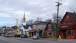
Conway is a census-designated place (CDP) and the primary village in the town of Conway in Carroll County, New Hampshire, United States. The population was 3,576 at the 2020 census. It is the most populous community in the town of Conway, ahead of North Conway.

<span class="mw-page-title-main">Conway, New Hampshire</span> Town in New Hampshire, United States

Conway is a town in Carroll County, New Hampshire, United States. It is the most populous community in the county, with a population of 9,822 at the 2020 census, down from 10,115 at the 2010 census. The town is on the southeastern edge of the White Mountain National Forest. There are five villages in the town: Conway, North Conway, Center Conway, Redstone and Kearsarge. Additionally, it shares a portion of the village of Intervale with the neighboring town of Bartlett.

<span class="mw-page-title-main">Whitefield, New Hampshire</span> Town in New Hampshire, United States

Whitefield is a town in Coös County, New Hampshire, United States, in the White Mountains Region. The population was 2,490 at the 2020 census. Situated on the northern edge of the White Mountains, Whitefield is home to the Mount Washington Regional Airport and the White Mountains Regional High School.

<span class="mw-page-title-main">Redstone, New Hampshire</span> Unincorporated community in New Hampshire, United States

Redstone is an unincorporated community within the town of Conway in Carroll County, New Hampshire, United States. It is located on the road from Center Conway to North Conway at the base of Rattlesnake Mountain. From the late 19th century until circa 1950, Redstone was known for its quarry of "red" granite which was mined extensively.

<span class="mw-page-title-main">Bartlett (CDP), New Hampshire</span> Census-designated place in New Hampshire, United States

Bartlett is a census-designated place (CDP) and the main village in the town of Bartlett in Carroll County, New Hampshire, United States. The population was 351 at the 2020 census, out of 3,200 in the entire town of Bartlett.

Carroll Reed (1905–1995) was a ski instructor and promoter of the sport of skiing in New Hampshire, United States. He was the developer of the Eastern Slope Ski School and among the developers of the Cranmore Mountain Resort in North Conway, New Hampshire. Carroll Reed, along with Bob Levy, purchased the North Conway railroad station and yard. The two brought in Dwight Smith and the three founded the Conway Scenic Railroad in 1974. Car #3234 is named after Carrol Reed.

References

  1. "ArcGIS REST Services Directory". United States Census Bureau. Retrieved September 20, 2022.
  2. "North Conway CDP, New Hampshire: 2020 DEC Redistricting Data (PL 94-171)". U.S. Census Bureau. Retrieved November 2, 2021.
  3. "Cathedral and Whitehorse Ledges". Dartmouth Outing Club. Retrieved June 22, 2010.
  4. "Black Cap". Boy Scout Troop 49. Lynnfield, Massachusetts. July 24, 2002.
  5. "Pudding Pond Loop Nature Walk". Open World Explorers.
  6. "Green Hills Preserve grows by 1,300 acres". Conway Daily Sun. November 13, 2014.
  7. "Freedom of the Hills: Black Cap Mountain". Bridgton News. May 17, 2012.
  8. "US Gazetteer files: 2010, 2000, and 1990". United States Census Bureau. February 12, 2011. Retrieved April 23, 2011.
  9. "2021 U.S. Gazetteer Files – New Hampshire". United States Census Bureau. Retrieved November 2, 2021.
  10. "NowData – NOAA Online Weather Data". National Oceanic and Atmospheric Administration . Retrieved May 20, 2022.
  11. "U.S. Climate Normals Quick Access – Station: N Conway, NH". National Oceanic and Atmospheric Administration. Retrieved February 9, 2023.
  12. "Decennial Census Official Publications". Census.gov. Retrieved March 4, 2024.
  13. 1 2 3 "Profile of General Population and Housing Characteristics: 2010 Demographic Profile Data (DP-1): North Conway CDP, New Hampshire". U.S. Census Bureau, American Factfinder. Archived from the original on February 10, 2020. Retrieved April 3, 2013.
  14. "Selected Economic Characteristics: 2007-2011 American Community Survey 5-Year Estimates (DP03): North Conway CDP, New Hampshire". U.S. Census Bureau, American Factfinder. Archived from the original on February 12, 2020. Retrieved April 3, 2013.
  15. Plymouth State Athletics: 2002 HOF Inductees. Accessed May 10, 2008
  16. "Babe Ruth's Daughter, Julia Ruth Stevens, Represents TW Museum at 2008 Eastern League All-Star Game". www.tedwilliamsmuseum.com. Retrieved February 2, 2011. Quote: "Years of living in North Conway, NH, and watching the Red Sox on local TV have made her a true Boston fan."