Genesee Valley Canal

Last updated
Genesee Valley Canal
Genesee Valley Canal aqueduct.jpg
Aqueduct in Portageville, New York over the Genesee River
Specifications
Length124 miles (200 km)
Locks106
Statusclosed
History
Original ownerNew York State
Date of first useSeptember 1, 1840
Date completed1862
Date closedSeptember 30, 1878
Geography
Start point Erie Canal in Rochester, New York
End point Allegheny River near Olean, New York
Branch(es)Dansville branch

The Genesee Valley Canal is a former canal that operated in western New York between 1840 and 1878. [1] It ran for a length of 124 miles, passing through 106 locks. [1] Its course was later used by the Genesee Valley Canal Railroad and today comprises portions of the Genesee Valley Greenway.

Contents

History

Demand for a canal had increased in the first third of the 19th Century as new settlers cleared the fertile lands along the Genesee River to plant crops such as wheat. [1] Farmers sought a way to transport their crops north to Rochester as the Genesee's cataracts made boat transport ineffective.

On 6 May 1836, an act was passed in the New York Legislature authorizing the construction of the Genesee Valley Canal. It was to run from the Erie Canal on the south side of Rochester south-southwest along the Genesee River valley to Mount Morris, Portageville, and Belfast, and then cross-country to the Allegheny River at Olean, with a branch from Mount Morris paralleling Canaseraga Creek to Dansville.

Construction

According to New York State archives, the reservoir supplying the summit level impounded 68,000,000 cubic feet (1,900,000 m3) of water. A non-navigable feeder creek carried water to the summit at Hinsdale after crossing Oil Creek on an aqueduct. Thirteen feeder creeks fed the Genesee Valley Canal. The Ischua Creek runs north to south to the Allegheny River and the still waters of the Ischua run deep, the town of Ischua was the perfect area to build a dam and utilize the water-way. Routing the canal through the Ischua-Hinsdale area enabled merchants to transport commerce from Rochester to Pittsburgh. The contract for the culverts on the Ischua feeder, as well as on lock sections 98 through 101, in Maplehurst, was awarded to Joseph T. Lyman and Dauphin Murray on Oct. 11, 1839. [2]

The canal builders faced considerable difficulty getting past the Portage Falls gorge in what is now part of Letchworth State Park. This resulted in the building of a 400 foot aqueduct that ran 50 feet above the Genesee River. [3]

Opening

On 1 September 1840, the canal was opened to navigation from Rochester to Mount Morris. The extension to Dansville opened in the fall of 1841, and by then the split between the Dansville branch and the main line was set at Sonyea, southeast of Mount Morris.

After some partial openings, the full line was opened at the beginning of navigation in 1862, running to Olean on the Allegheny River and beyond to Mill Grove, on the river just north of the Pennsylvania state line. However, by then, the Main Line of Public Works and Pennsylvania Railroad had been completed, opening up the interior of Pennsylvania without depending on New York, and there was no interest in improving the Allegheny River, which proved to only be able to handle large ships when its water level was at its highest in the spring. Instead, the Buffalo, Bradford and Pittsburgh Railroad, connecting to the river at Carrollton, west of Olean, was used as a reason to continue building the canal.

Closing

On 4 June 1877, the legislature approved an abandonment of the canal on or after 30 September 1878. The canal was sold on 6 November 1880 to the Genesee Valley Canal Railroad, which had been chartered 15 July of that year.

Visible remnants

The canal is long gone, but its remnants [4] form the Genesee Valley Greenway. Sites like the remnants of the Ischua Dam can be seen by visiting the Town of Ischua Historical Society and Park, on the corner of Route 16 and Farwell Road in the Town of Ischua. Further down Route 16, the Hinsdale VFW post has highlighted the remnants of the lock system of the Genesee Valley Canal located there, both in Cattaraugus County near the Olean terminus.

Cuba Lake, originally known as Oil Creek Reservoir, located in the town of Cuba in Allegany County, was created in 1858 to help maintain water levels on the Genesee Valley Canal. Cuba Lake and its surrounding land is owned by New York State. Today, cottage and home sites on the lake are officially leased from the state as part of the Cuba Lake District.

Related Research Articles

<span class="mw-page-title-main">Erie Canal</span> Waterway in New York, U.S.

The Erie Canal is a historic canal in upstate New York that runs east–west between the Hudson River and Lake Erie. Completed in 1825, the canal was the first navigable waterway connecting the Atlantic Ocean to the Great Lakes, vastly reducing the costs of transporting people and goods across the Appalachians. In effect, the canal accelerated the settlement of the Great Lakes region, the westward expansion of the United States, and the economic ascendancy of New York State. It has been called "The Nation's First Superhighway."

<span class="mw-page-title-main">Allegheny River</span> River in Pennsylvania and New York, United States

The Allegheny River is a 325-mile-long (523 km) headwater stream of the Ohio River that is located in western Pennsylvania and New York in the United States. It runs from its headwaters just below the middle of Pennsylvania's northern border, northwesterly into New York, then in a zigzag southwesterly across the border and through Western Pennsylvania to join the Monongahela River at the Forks of the Ohio at Point State Park in Downtown Pittsburgh, Pennsylvania.

<span class="mw-page-title-main">Cattaraugus County, New York</span> County in New York, United States

Cattaraugus County is a county in Western New York, with one side bordering Pennsylvania. As of the United States 2020 census, the population was 77,042. The county seat is Little Valley. The county was created in 1808 and later organized in 1817. The county is part of the Western New York region of the state.

<span class="mw-page-title-main">Livingston County, New York</span> County in New York, United States

Livingston County is a county in the U.S. state of New York. As of the 2020 census, the population was 61,834. Its county seat is Geneseo. The county is named after Robert R. Livingston, who helped draft the Declaration of Independence and negotiated the Louisiana Purchase. The county is part of the Finger Lakes region of the state.

<span class="mw-page-title-main">Letchworth State Park</span> State park in New York state, United States

Letchworth State Park is a 14,427-acre (5,838 ha) New York State Park located in Livingston County and Wyoming County in the western part of the State of New York. The park is roughly 17 miles (27 km) long, following the course of the Genesee River as it flows north through a deep gorge and over several large waterfalls. It is located 35 miles (56 km) southwest of Rochester and 60 miles (97 km) southeast of Buffalo, and spans portions of the Livingston County towns of Leicester, Mount Morris and Portage, as well as the Wyoming County towns of Castile and Genesee Falls.

<span class="mw-page-title-main">Ischua, New York</span> Town in New York, United States

IschuaISH-way is a town in Cattaraugus County, New York, United States. The population was 736 at the 2020 census. Ischua is also the name of a hamlet in the town. The town is on the eastern border of the county, north of Olean.

<span class="mw-page-title-main">Olean, New York</span> City in New York, United States

Olean is a city in Cattaraugus County, New York, United States. Olean is the largest city in Cattaraugus County and serves as its financial, business, transportation and entertainment center. It is one of the principal cities of the Southern Tier region of Western New York.

Mount Morris is a village in the town of Mount Morris in Livingston County, New York, United States. The village population was 2,986 at the 2010 census, out of 4,465 in the entire town. The village and town are named after Robert Morris.

<span class="mw-page-title-main">Genesee River</span> River in New York and Pennsylvania

The Genesee River is a tributary of Lake Ontario flowing northward through the Twin Tiers of Pennsylvania and New York in the United States. The river contains several waterfalls in New York at Letchworth State Park and Rochester.

<span class="mw-page-title-main">Glacial geology of the Genesee River</span>

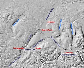
The Genesee River flows northward from its source in northern Pennsylvania to enter Lake Ontario at Rochester, New York.

<span class="mw-page-title-main">Mount Morris Dam</span> Dam in Livingston County

The Mount Morris Dam is a concrete gravity dam on the Genesee River. It is located at the northern end of Letchworth State Park, south of Rochester, New York in the towns of Leicester and Mount Morris in Livingston County, New York. It is the largest dam of its type east of the Mississippi River and its purpose is to mitigate downstream flooding between Mount Morris and Lake Ontario.

<span class="mw-page-title-main">Ohio and Erie Canal</span> 19th-century manmade water route between Akron and Cleveland, Ohio, USA

The Ohio and Erie Canal was a canal constructed during the 1820s and early 1830s in Ohio. It connected Akron with the Cuyahoga River near its outlet on Lake Erie in Cleveland, and a few years later, with the Ohio River near Portsmouth. It also had connections to other canal systems in Pennsylvania.

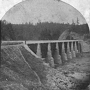
The Genesee Valley Canal Railroad was a part of the Pennsylvania Railroad system in western New York. It was built on the former Genesee Valley Canal alignment.

<span class="mw-page-title-main">New York State Route 63</span> State highway in the western part of New York in the United States

New York State Route 63 (NY 63) is a state highway in the western part of New York in the United States. It extends for 82.11 miles (132.14 km) in a generally southeast–northwest direction from an intersection with NY 15 and NY 21 in the village of Wayland in Steuben County to a junction with NY 18 in the town of Yates in Orleans County, 2 miles (3.2 km) south of the Lake Ontario shoreline. The route passes through the city of Batavia and enters or comes near several villages, including Dansville and Medina.

<span class="mw-page-title-main">New York State Route 446</span> State highway in the Southern Tier of New York, U.S.

New York State Route 446 (NY 446) is a state highway in the Southern Tier of New York in the United States. The highway extends for 6.76 miles (10.88 km) on a northeast–southwest alignment from an intersection with NY 16 north of the hamlet of Hinsdale to a junction with NY 305 in the village of Cuba. It parallels the Southern Tier Expressway very closely for its entire length. NY 446 was originally designated as part of Route 4, an unsigned legislative route, in 1908. The Hinsdale–Cuba highway received its first posted designation in 1924 when it was included as part of NY 17. It was renumbered twice, becoming part of NY 63 in 1930 and NY 408 in the 1940s, before gaining its current designation on July 1, 1974.

<span class="mw-page-title-main">Genesee Valley Greenway</span>

The Genesee Valley Greenway is a rail trail in western New York's Genesee River valley.

<span class="mw-page-title-main">Pennsylvania Canal</span> Former canal network in Pennsylvania

The Pennsylvania Canal, sometimes known as the Pennsylvania Canal system, was a complex system of transportation infrastructure improvements, including canals, dams, locks, tow paths, aqueducts, and viaducts. The canal was constructed and assembled over several decades beginning in 1824, the year of the first enabling act and budget items.

<span class="mw-page-title-main">Beaver and Erie Canal</span>

The Beaver and Erie Canal, also known as the Erie Extension Canal, was part of the Pennsylvania Canal system and consisted of three sections: the Beaver Division, the Shenango Division, and the Conneaut Division. The canal ran 136 miles (219 km) north–south near the western edge of the state from the Ohio River to Lake Erie through Beaver County, Lawrence County, Mercer County, Crawford County, and Erie County, Pennsylvania.

The Western New York and Pennsylvania Railway was a railroad that operated in the U.S. states of New York and Pennsylvania.

Cuba Lake is a 454-acre (1.84 km2) reservoir in Allegany and Cattaraugus counties, New York.

References

  1. 1 2 3 "Remembering the Genesee Valley Canal, Part I by Richard Palmer". www.crookedlakereview.com. Retrieved 2019-04-28.
  2. http://www.justluxe.com/syndicated-news/cid939197/Genesee-Valley-Canal-Part-I-The-Ischua-Dam Archived 2016-03-04 at the Wayback Machine |
  3. "Letchworth Photo Album". www.letchworthparkhistory.com. Retrieved 2019-04-28.
  4. "Landmarks of the Genesee Valley Canal".

42°16′21″N78°14′00″W / 42.27250°N 78.23333°W / 42.27250; -78.23333