Genesee Valley Greenway

Last updated
Genesee Valley Greenway
Genesee-Valley-Greenway-Trailblazer.svg
Genesee Valley Greenway Trail Blaze
Length90 mi (140 km)
Location New York, United States
Trailheads Rochester, New York
Cuba, New York
UseHiking, cycling, horseback riding, and cross-country skiing
SeasonAll year
Sights Letchworth State Park
Right of way Pennsylvania Railroad, Genesee Valley Canal

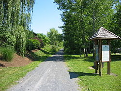
The Genesee Valley Greenway is a rail trail in western New York's Genesee River valley.

Contents

The trail stretches for 90 miles (140 km) along a former Pennsylvania Railroad right-of-way as well as adjacent land from the Genesee Valley Canal. The low grade path is a multi-use trail which is well suited for hiking, biking, horsebacking riding and cross-country skiing. [1]

The Greenway is administered by the New York State Office of Parks, Recreation and Historic Preservation (NYS OPRHP) and the Friends of the Genesee Valley Greenway. The New York State Department of Environmental Conservation was a partner in the Greenway's management prior to transferring jurisdiction of their lands to NYS OPRHP in 2010. [2] The project began in 1991 as a way to reuse mostly abandoned land from the old railways. Construction and renovation of land for the trail was underway in 1998. [3]

The Genesee Valley Greenway intersects with the Erie Canal Heritage Trail south of the city of Rochester at the Genesee Valley Park, thereby forming part of a network of green corridors for hikers and cyclists stretching across New York State. As of 2016, the Greenway passes through Monroe, Livingston, Wyoming and Allegany counties, connecting the City of Rochester and the Village of Cuba, with plans to eventually extend the trail to Hinsdale in Cattaraugus County. [1]

Trail conditions

Because the northern portions of the Greenway are converted railroad track bed, it is relatively smooth, straight, and level. Portions of the trail near to, and south of, Letchworth State Park are very hilly and strenuous.

Where the trail crosses highways and waterways, many of the structures used to support the previous railway are either reused, or new prefabricated bridges have been placed on old bridge abutments. Roads that cross the Greenway fall in two general categories: Roads constructed while the railway or Greenway was in operation, which typically have the road on an even grade with the Greenway or (for larger highways) a bridge where one crosses the other; and roads constructed while the railway was abandoned, whose intersections may be difficult to cross because of differences in elevation between the roadway and the Greenway, sometimes accomplished via steep inclines or switchbacks.

Places of historic interest

Intersection of the Greenway with the Lehigh Valley Trail at Wadsworth Junction, as marked by the white plaque seen on the right. Genesee Valley Greenway intersect Lehigh Valley Trail.jpg
Intersection of the Greenway with the Lehigh Valley Trail at Wadsworth Junction, as marked by the white plaque seen on the right.

Because of the historic nature of much of the land that the Greenway traverses, points of interest along the trail are marked by plaques with descriptions of the significance of the site, along with historic photographs and maps.

Among the marked sites are:

Related Research Articles

<span class="mw-page-title-main">Letchworth State Park</span> State park in New York state, United States

Letchworth State Park is a 14,427-acre (5,838 ha) New York State Park located in Livingston County and Wyoming County in the western part of the State of New York. The park is roughly 17 miles (27 km) long, following the course of the Genesee River as it flows north through a deep gorge and over several large waterfalls. It is located 35 miles (56 km) southwest of Rochester and 60 miles (97 km) southeast of Buffalo, and spans portions of the Livingston County towns of Leicester, Mount Morris and Portage, as well as the Wyoming County towns of Castile and Genesee Falls.

Mount Morris is a village in the town of Mount Morris in Livingston County, New York, United States. The village population was 2,986 at the 2010 census, out of 4,465 in the entire town. The village and town are named after Robert Morris.

<span class="mw-page-title-main">Chenango Canal</span> United States historic place

The Chenango Canal was a towpath canal in central New York in the United States which linked the Susquehanna River to the Erie Canal. Built and operated in the mid-19th century, it was 97 miles long and for much of its course followed the Chenango River, along New York State Route 12 from Binghamton on the south end to Utica on the north. It operated from 1834 to 1878 and provided a significant link in the water transportation system of the northeastern U.S. until supplanted by the region's developing railroad network.

<span class="mw-page-title-main">Rail trail</span> Railroad bed converted to a recreational trail

A rail trail is a shared-use path on railway right of way. Rail trails are typically constructed after a railway has been abandoned and the track has been removed, but may also share the right of way with active railways, light rail, or streetcars, or with disused track. As shared-use paths, rail trails are primarily for non-motorized traffic including pedestrians, bicycles, horseback riders, skaters, and cross-country skiers, although snowmobiles and ATVs may be allowed. The characteristics of abandoned railways—gentle grades, well-engineered rights of way and structures, and passage through historical areas—lend themselves to rail trails and account for their popularity. Many rail trails are long-distance trails, while some shorter rail trails are known as greenways or linear parks.

<span class="mw-page-title-main">Rochester subway</span> Former light rail rapid transit line in the city of Rochester, New York

The Rochester Industrial and Rapid Transit Railway, more commonly known as the Rochester subway, was a light rail rapid transit line in the city of Rochester, New York, from 1927 to 1956. The subway was constructed in the bed of the old Erie Canal, which allowed the route to be grade-separated for its entire length. Two miles (3.2 km) of the route through downtown were constructed in a cut-and-cover tunnel that became Broad Street, and the only underground portion of the subway. The Rochester Subway was designed to reduce interurban traffic on city streets, and to facilitate freight interchange between the railroads. The line was operated on a contract basis by New York State Railways until Rochester Transit Corporation (RTC) took over in 1938. The last day of passenger service was June 30, 1956. Portions of the right-of-way were used for expressway construction, while the rest was abandoned and filled in over the years. The largest remaining section is a stretch of tunnel under Broad Street from Exchange Street to the intersection of Court Street and South Avenue.

The Auburn and Rochester Railroad was a railroad company based in New York state in the 19th century.

The Genesee Valley Canal Railroad was a part of the Pennsylvania Railroad system in western New York. It was built on the former Genesee Valley Canal alignment.

<span class="mw-page-title-main">Wallkill Valley Rail Trail</span> Rail Trail in the Wallkill Valley

The Wallkill Valley Rail Trail is a 23.7-mile (38.1 km) rail trail and linear park that runs along the former Wallkill Valley Railroad rail corridor in Ulster County, New York, United States. It stretches from Gardiner through New Paltz, Rosendale and Ulster to the Kingston city line, just south of a demolished, concrete Conrail railroad bridge that was located on a team-track siding several blocks south of the also-demolished Kingston New York Central Railroad passenger station. The trail is separated from the Walden–Wallkill Rail Trail by two state prisons in Shawangunk, though there have been plans to bypass these facilities and to connect the Wallkill Valley Rail Trail with other regional rail-trails. The northern section of the trail forms part of the Empire State Trail.

<span class="mw-page-title-main">Genesee Valley Park</span>

Genesee Valley Park, originally named "South Park," is located in the south side of Rochester, New York along the shores of the Genesee River. The New York State Barge Canal crosses the Genesee River within the park. The University of Rochester is located near the park's north entrance.

Parks & Trails New York is New York's leading statewide advocate for parks and trails, dedicated since 1985 to improving our health, economy, and quality of life through the use and enjoyment of green space.

<span class="mw-page-title-main">Rochester & Genesee Valley Railroad Museum</span> Railroad museum in Industry, New York

The Rochester and Genesee Valley Railroad Museum (RGVRRM) is an operating railroad museum located in Industry, New York, a hamlet within the town of Rush. The museum started in 1971 with the purchase of a former Erie Railroad Depot from the Erie Lackawanna Railroad. Since then the museum has grown to include a one-mile demonstration railroad, connecting it with the New York Museum of Transportation in Rush, making it one of the only operating railroad museums in New York State. The museum was formerly an operation of the Rochester Chapter National Railway Historical Society until 2011. The organization rosters more than 40 pieces of historic railroad equipment, including diesel and steam locomotives, electric trolley and multiple-unit cars, freight cars, cabooses, passenger cars, and work equipment. The museum campus includes a number of preserved railroad structures, including the 1909 Industry Depot built by the Erie Railroad, a waiting shelter from the Rochester, Lockport & Buffalo Railroad, and a crossing watchman's shanty from the New York Central. Train rides are operated and the museum is open to the public on select weekends from June through October, and is staffed entirely by volunteers.

<span class="mw-page-title-main">Broad Street Bridge (Rochester, New York)</span> United States historic place

Erie Canal: Second Genesee Aqueduct, also known as the Broad Street Aqueduct or Broad Street Bridge, is a historic stone aqueduct located at Rochester in Monroe County, New York. It was constructed in 1836–1842 and originally carried the Erie Canal over the Genesee River. The overall length of the aqueduct including the wings and abutments is 800 feet (240 m). The aqueduct is 70 feet (21 m) wide and has large parapets on either side. It is one of four major aqueducts in the mid-19th century Erie Canal system. In 1927, a roadbed was added to carry automobile traffic and named Broad Street. It also carried a part of the Rochester Subway.

<span class="mw-page-title-main">Lehigh Valley Railroad Station (Rochester, New York)</span>

Lehigh Valley Railroad Station is a historic railway station located at Rochester in Monroe County, New York. The Lehigh Valley Railroad built the station in 1905 but stopped using the station for passenger service in the 1950s. Later the station was used as a bus terminal and then as a night club. In the 1980s the building was added to the National Register of Historic Places and today it houses the Dinosaur Bar-B-Que restaurant.

<span class="mw-page-title-main">Erie Lackawanna Trail</span> Rail trail in Lake County, Indiana, U.S.

Erie Lackawanna Trail is a rail trail located in Lake County, Indiana, which runs along the former Erie Lackawanna Railway. The trail begins in the city of Hammond then passes through the towns of Highland, Griffith, Schererville, and Merrillville before coming to an end in the county seat Crown Point. It covers a total of 17.7 miles (28.5 km).

The Pat McGee Trail is a rail trail in Cattaraugus County, New York, United States, named for Patricia McGee (1934-2005).

<span class="mw-page-title-main">Phillipsburg Union Station</span>

Phillipsburg Union Station is an inactive railroad station in Phillipsburg, New Jersey, United States, at 178 South Main Street. Opened in 1914, Union Station was built by the Delaware, Lackawanna & Western Railroad (DL&W) and shared with the Central Railroad of New Jersey (CNJ) and was situated where the lines merged before the bridge crossing the Delaware River. Designed by Frank J. Nies, the architect who produced many of DL&W stations now listed state and federal registers of historic places, the 2+12 story, 3 bay brick building is unusual example of a union station and a representation of early 20th century Prairie style architecture. The Phillipsburg Union Signal Tower, or PU Tower, is nearby.

References

  1. 1 2 "Genesee Valley Greenway State Park". NYS Office of Parks, Recreation & Historic Preservation. Retrieved February 14, 2016.
  2. "Genesee Valley Greenway State Park Management Plan - Introduction" (PDF). NYS Office of Parks, Recreation & Historic Preservation. December 30, 2013. Retrieved February 15, 2016.
  3. "Appendix K: History of the Genesee Valley Greenway State Park". Genesee Valley Greenway State Park Management Plan - Appendices (PDF). NYS Office of Parks, Recreation & Historic Preservation. December 30, 2013. Retrieved February 15, 2016.
  4. "Erie-Lackawanna Rails-to-Trails Pedestrian Bridge". City of Rochester. Retrieved February 14, 2016.