Ontario Pathways Rail Trail

Last updated
Bridge over Route 5 & 20 Rail trail bridge.jpg
Bridge over Route 5 & 20

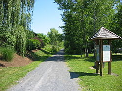
Ontario Pathways Rail Trail is a hiking and cycling trail located in Ontario County, New York. The total trail mileage is 23 with pathways branching in two directions. The trail connects Canandaigua, Stanley, and Phelps. [1] In addition to the main hiking and cycling trails, Ontario Pathways includes four loop trails.

The two main pathways of the trail were built over a pair of former Pennsylvania Railroad lines. The trail was severed in June 2010 when an incident involving a piece of agricultural machinery took out a railroad bridge over routes 5 & 20; this was later replaced in 2013 with a simple arched pedestrian bridge. [2]

Related Research Articles

<span class="mw-page-title-main">Trans Canada Trail</span> Network of multiuse trails across Canada

The Trans Canada Trail, officially named The Great Trail between September 2016 and June 2021, is a cross-Canada system of greenways, waterways, and roadways that stretches from the Atlantic to the Pacific to the Arctic oceans. The trail extends over 24,000 km (15,000 mi); it is now the longest recreational, multi-use trail network in the world. The idea for the trail began in 1992, shortly after the Canada 125 celebrations. Since then it has been supported by donations from individuals, corporations, foundations, and all levels of government.

<span class="mw-page-title-main">Multnomah Falls</span> Waterfall in Oregon, U.S.

Multnomah Falls is a waterfall located on Multnomah Creek in the Columbia River Gorge, east of Troutdale, between Corbett and Dodson, Oregon, United States. The waterfall is accessible from the Historic Columbia River Highway and Interstate 84. Spanning two tiers on basalt cliffs, it is the tallest waterfall in the state of Oregon at 620 ft (189 m) in height. The Multnomah Creek Bridge, built in 1914, crosses below the falls, and is listed on the National Register of Historic Places.

<span class="mw-page-title-main">Rail trail</span> Railroad bed converted to a recreational trail

A rail trail is a shared-use path on railway right of way. Rail trails are typically constructed after a railway has been abandoned and the track has been removed, but may also share the right of way with active railways, light rail, or streetcars, or with disused track. As shared-use paths, rail trails are primarily for non-motorized traffic including pedestrians, bicycles, horseback riders, skaters, and cross-country skiers, although snowmobiles and ATVs may be allowed. The characteristics of abandoned railways—gentle grades, well-engineered rights of way and structures, and passage through historical areas—lend themselves to rail trails and account for their popularity. Many rail trails are long-distance trails, while some shorter rail trails are known as greenways or linear parks.

<span class="mw-page-title-main">Fish Creek Provincial Park</span> Park in Calgary, Alberta, Canada

Fish Creek Park is an urban provincial park that preserves the valley of Fish Creek in the southern part of Calgary, Alberta, Canada. It is bordered on three sides by the city, and on the west by the territory of the Tsuu T’ina Nation (Sarcee), a First Nation.

<span class="mw-page-title-main">Welland Recreational Waterway</span>

The Welland Recreational Waterway is a water channel in the city of Welland, Ontario, Canada. It is an old alignment of the Welland Ship Canal that was abandoned after the construction of the Welland By-Pass in the 1970s. The Waterway is now managed by the Welland Recreational Canal Corporation to provide enjoyment for the city's residents. Most local residents refer to it as the old canal or simply the canal.

<span class="mw-page-title-main">Greenway (landscape)</span> Shared-use path or linear park with vegetation

A greenway is usually a shared-use path along a strip of undeveloped land, in an urban or rural area, set aside for recreational use or environmental protection. Greenways are frequently created out of disused railways, canal towpaths, utility company rights of way, or derelict industrial land. Greenways can also be linear parks, and can serve as wildlife corridors. The path's surface may be paved and often serves multiple users: walkers, runners, bicyclists, skaters and hikers. A characteristic of greenways, as defined by the European Greenways Association, is "ease of passage": that is that they have "either low or zero gradient", so that they can be used by all "types of users, including mobility impaired people".

This is a list of trails in Ithaca, New York.

<span class="mw-page-title-main">Air Line State Park Trail</span> Rail trail in Connecticut, US

The Air Line State Park Trail is a rail trail and linear state park located in Connecticut. The trail is divided into sections designated South, North a piece of the East Coast Greenway, and the Thompson addition. An additional 3.6-mile spur to Colchester is sometimes designated as part of the Air Line trail. At the Massachusetts state line, the trail connects to the Southern New England Trunkline Trail, a 22-mile-long trail to Franklin, MA built on the same right-of-way. Since 2018, the town of Portland, CT has also maintained a 2.3-mile portion of the Air Line trail, connecting to the southern end of the state park at the town line with East Hampton.

<span class="mw-page-title-main">Susquehannock Trail System</span> Long-distance hiking trail in the United States

The Susquehannock Trail System (STS) is an 83.4-mile (134.2 km) loop hiking trail in Susquehannock State Forest in Potter County in north-central Pennsylvania, United States. The trail walks through two state parks and passes near three more state parks. It also traverses Hammersley Wild Area, the largest area in Pennsylvania without a road. The loop is supplemented by two cross-connector trails, several short access trails, a shared path with the Donut Hole Trail, and two connectors to the Black Forest Trail. The STS is the oldest backpacking trail in Pennsylvania, and has been noted for its solitude while traversing remote areas with few signs of civilization. The STS also includes several overnight shelters.

<span class="mw-page-title-main">Dequindre Cut</span>

The Dequindre Cut is a below-grade pathway, formerly a Grand Trunk Western Railroad line, located on the east side of Detroit, Michigan, just west of St. Aubin Street. Much of the Cut has been converted to a greenway; the colorful graffiti along the pathway has been left in place.

<span class="mw-page-title-main">Cycling in Detroit</span>

Detroit is a popular city for cycling. It is flat with an extensive road network with a number of recreational and competitive opportunities and is, according to cycling advocate David Byrne, one of the top eight biking cities in the world. The city has invested in greenways and bike lanes and other bicycle-friendly infrastructure. Bike rental is available from the riverfront and tours of the city's architecture can be booked.

<span class="mw-page-title-main">Trails in Detroit</span>

This is a list of trails and greenways in Detroit.

<span class="mw-page-title-main">Capital Pathway</span> Bike and pedestrian pathway in Canada

The Auburn Trail is a multi-use rail trail located principally in the towns of Victor and Farmington, Ontario County, New York (USA). It is approximately 11 miles (18 km) long and maintained by the Towns of Victor and Farmington and Victor Hiking Trails. The trail mostly follows the alignment of the Auburn and Rochester Railroad. Additional disconnected portions of the Auburn trail are found in the Towns of Pittsford and Brighton, Monroe County, NY. A detailed description and map of the Auburn Trail are available from Victor Hiking Trails.

<span class="mw-page-title-main">John P. Saylor Trail</span>

The John P. Saylor Trail is a 17.5-mile (28.2 km) hiking trail system in southwestern Pennsylvania, consisting of two loops with a short cross-connector trail, through Gallitzin State Forest in Somerset County. The trail is named after Congressman John P. Saylor, who sponsored the National Scenic Trails Act while supporting national wilderness preservation. The main loop, which can be reached from the trailhead, is 12.0 miles around. The south loop, which cannot be reached directly by car, can be combined with the main loop and the short cross-connector, for a "figure-8" hike of 17.5 miles.

<span class="mw-page-title-main">Prescott and Russell Recreational Trail</span> Trail in Ontario, Canada

The Prescott-Russell Recreational Trail is a 72 kilometres (45 mi) long rail trail in Prescott-Russell, Ontario, Canada, maintained by the county of Prescott-Russell. The trail begins in the village of Saint-Eugène and goes to the eastern boundary of the City of Ottawa, passing through the townships of East Hawkesbury, Champlain, The Nation, Alfred and Plantagenet, and Clarence-Rockland.

<span class="mw-page-title-main">Cleveland Foundation Centennial Lake Link Trail</span>

The Cleveland Foundation Centennial Lake Link Trail, originally known as the Lake Link Trail, is a cycling, hiking, and walking trail located in the city of Cleveland, Ohio, in the United States. Owned by the city of Cleveland and maintained by Cleveland Metroparks, the trail runs along the former track bed of the Cleveland and Mahoning Valley Railroad. The trail is named for The Cleveland Foundation, a local community foundation which donated $5 million toward the trail's construction. The southern leg of the 1.3-mile (2.1 km) trail opened in August 2015, and the northern leg in August 2017. The middle leg will begin construction once the Irishtown Bend hillside is stabilized. A bridge connecting the trail to Whiskey Island will begin construction in Spring 2019 and will be completed in early Summer 2020.

<span class="mw-page-title-main">Bowmont Park</span> Public park in Calgary, Alberta

Bowmont Park or Bowmont Natural Environment Park is a 192 hectares urban park on the northern bank of the Bow River in the northwest of the city of Calgary in the communities of Bowness and Montgomery. 'Bowmont' is a combination of their names. The Park was created in the 1980s. The escarpment formed by the Glacial Lake Calgary, runs the length of the park. Both Silver Springs and Varsity communities are perched at the top of the escarpment overlooking the Bow River and are access points to the Park. Bordering the northern banks of the Bow River, the park is includes "grasslands, gullies, valleys, a waterfall with a lookout, off-leash dog-walking areas, hiking, walking and cycling trails, access to the river for swimming and fishing, and more. The most recent expansion of Bowmont Park, Dale Hodges Park which was opened to the public in June 2019, includes innovative public art in the form of sculpted land structures that treat stormwater before it enters the Bow River through the outfall.

<span class="mw-page-title-main">Trails in Minneapolis</span>

Minneapolis is often considered one of the top biking and walking cities in the United States due to its vast network of trails and dedicated pedestrian areas. In 2020, Walk Score rated Minneapolis as 13th highest among cities over 200,000 people. Some bicycling ratings list Minneapolis at the top of all United States cities, while others list Minneapolis in the top ten. There are over 80 miles (130 km) of paved, protected pathways in Minneapolis for use as transportation and recreation. The city's Grand Rounds National Scenic Byway parkway system accounts for the vast majority of the city's shared-use paths at approximately 50 miles (80 km) of dedicated biking and walking areas. By 2008, other city, county, and park board areas accounted for approximately 30 miles (48 km) of additional trails, for a city-wide total of approximately 80 miles (130 km) of protected pathways. The network of shared biking and walking paths continued to grow into the late 2010s with the additions of the Hiawatha LRT Trail gap remediation, Min Hi Line pilot projects, and Samatar Crossing. The city also features several natural-surface hiking trails, mountain-biking paths, groomed cross-country ski trails in winter, and other pedestrian walkways.

References

  1. Ontario Pathways Map
  2. Collingsworth, Tiffany (July 24, 2013). "Bridge Over 5&20 in Flint to Begin Repairs". fingerlakesdailynews.com. Finger Lakes Daily News . Retrieved March 4, 2015.