
Albany County is a county in the state of New York, United States. Its northern border is formed by the Mohawk River, at its confluence with the Hudson River, which is to the east. As of the 2020 United States Census, the population was 314,848. The county seat and largest city is Albany, which is also the state capital of New York. As originally established by the English government in the colonial era, Albany County had an indefinite amount of land, but has had an area of 530 square miles (1,400 km2) since March 3, 1888. The county is named for the Duke of York and of Albany, who became James II of England. The county is part of the Capital District region of the state.
Montgomery County is a county in the U.S. state of New York. As of the 2020 census, the population was 49,532. The county seat is Fonda. The county was named in honor of Richard Montgomery, an American Revolutionary War general killed in 1775 at the Battle of Quebec. The county is part of the Mohawk Valley region of the state.

Schoharie County is a county in the U.S. state of New York. As of the 2020 census, the population was 29,714, making it the state's fifth-least populous county. The county seat is Schoharie. "Schoharie" comes from a Mohawk word meaning "floating driftwood." Schoharie County is part of the Albany-Schenectady-Troy, NY Metropolitan Statistical Area. The county is part of the Mohawk Valley region of the state.

Mohawk is a town in Montgomery County, New York, United States. The population was 3,844 at the 2010 census.

Major-General Sir William Johnson, 1st Baronet, was a British Army officer and colonial administrator from Ireland known for his military and governance work in British colonial America.
Johnstown is a town located in Fulton County, New York, United States. As of the 2010 census, the town had a population of 7,098. The name of the town is from landowner William Johnson. The town of Johnstown is located on the southern border of the county. It borders on three sides the city of Johnstown and the city of Gloversville.

Johnstown is a city in and the county seat of Fulton County in the U.S. state of New York. The city was named after its founder, Sir William Johnson, Superintendent of Indian Affairs in the Province of New York and a major general during the Seven Years' War in North America. It is located approximately 45 miles (72 km) northwest of Albany, about one-third of the way between Albany and the Finger Lakes region to the west, in the Mohawk Valley region, within the foothills of the Adirondack Mountains.

The Mohawk Valley region of the U.S. state of New York is the area surrounding the Mohawk River, sandwiched between the Adirondack Mountains and Catskill Mountains, northwest of the Capital District. As of the 2010 United States Census, the region's counties have a combined population of 622,133 people. In addition to the Mohawk River valley, the region contains portions of other major watersheds such as the Susquehanna River.

Lieutenant-Colonel John Butler was a British Indian Department officer, landowner and merchant. During the American Revolutionary War, he was a prominent Loyalist who commanded Butler's Rangers. Born in New London, Connecticut, he moved to New York with his family, where he learned several Iroquoian languages and worked as an interpreter in the fur trade. He was well-prepared to work with the Mohawk and other Iroquois nations who became allies of the British during the rebellion.
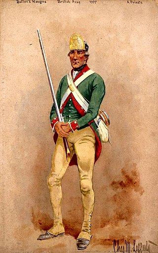
Butler's Rangers (1777–1784) was a Loyalist provincial military unit of the American Revolutionary War, raised by American loyalist John Butler. Most members of the regiment were Loyalists from upstate New York and northeastern Pennsylvania. Their winter quarters were constructed on the west bank of the Niagara River, in what is now Niagara-on-the-Lake, Ontario. The Rangers fought principally in New York and Pennsylvania, but ranged as far west as Ohio and Michigan, and as far south as Virginia and Kentucky.

The Capital District, also known as the Capital Region, is the metropolitan area surrounding Albany, the capital of the U.S. state of New York. The Capital District was first settled by the Dutch in the early 17th century and came under English control in 1664. Albany has been the permanent capital of the state of New York since 1797. The Capital District is notable for many historical events that predate the independence of the United States, including the Albany Plan of Union and the Battles of Saratoga.

Charlotte County was a county in the colonial Province of New York in the British American colonies. It was created from Albany County on March 24, 1772. The county was named for Charlotte of Mecklenburg-Strelitz, wife of George III of the United Kingdom. Its boundaries extended far further than any current county. Its western boundary ran from the northern boundary of Albany County to the Canada line, at a point near the old village of St. Regis. Its southern boundary was what is now the northern boundary of Saratoga County. Much of western Vermont, then claimed by New York, was also part of the county. Its northern border was also the Canada–US border. Its county seat was Fort Edward.

Brigadier-General Sir John Johnson, 2nd Baronet was an American-born military officer, politician and landowner who fought as a Loyalist during the American Revolutionary War. He was the son of Sir William Johnson, 1st Baronet, a prominent British Indian Department official in the Thirteen Colonies. Johnson inherited his father's baronetcy and estate in 1774.

Guy Johnson was a British Indian Department officer, judge and politician. He served on the side of the British during the American Revolutionary War, having migrated to the Province of New York as a young man and worked with his uncle, Sir William Johnson, 1st Baronet who served as the Superintendent of Indian Affairs of the northern colonies.
Colonel Sampson Sammons was an American officer in the American Revolutionary War. He is notable for being the target of the first shot fired by the British in the American Revolution west of the Hudson River.
The Battle of Klock's Field was an engagement during the American Revolutionary War in the Mohawk Valley region of New York between British and Loyalist forces led by Lieutenant Colonel Sir John Johnson, and New York militia and levies led by Brigadier General Robert Van Rensselaer. The battle occurred on the north side of the Mohawk River in what is now St. Johnsville in Montgomery County. The result was inconclusive with neither side able to claim a clear victory.
The creation of the Tryon County, New York militia was authorized on March 8, 1772, when the Province of New York passed a bill for the establishment of organized militia in each county in the colony. By 1776, the Tryon County militia had in effect become an army of rebellion under the control of the Tryon County Committee of Safety. The Tryon County militia would go on to fight at the important battles of Oriskany and Johnstown during the war.

The Fulton County Courthouse, originally the Tryon County Courthouse, and for a time the Montgomery County Courthouse, is a historic courthouse building located on North William Street at the corner of West Main Street in Johnstown, Fulton County, New York. It was built in 1772 to 1773 and is a Late Georgian style public building. It is the oldest existing Court House in the State of New York and one of the oldest in the United States still being used as a Court House. It was the county courthouse for Tryon and Montgomery Counties until May, 1836, when the county seat was moved to Fonda. After a time in private hands, it became the courthouse for the new Fulton County, created in April, 1838.
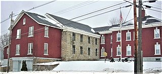
The Fulton County Jail, originally the Tryon County Jail, is a historic jail complex located at the corner of Perry and Montgomery Street in Johnstown, Fulton County, New York. The original section was built in 1772-1773 and was placed on the village's highest ground to give a defensive advantage in case of an attack by Native Americans or a war. At the time, it was thought to be one of the strongest defensive positions in colonial America, due to its placement and the thick wall, which would deflect everything but the very strongest artillery.
Douw Jellise Fonda (1700–1780) was a prominent settler and trader in the Mohawk Valley of New York State. The village of Fonda, New York is named for him.
