
Albany County is a county in the state of New York, United States. Its northern border is formed by the Mohawk River, at its confluence with the Hudson River, which is to the east. As of the 2020 United States Census, the population was 314,848. The county seat and largest city is Albany, which is also the state capital of New York. As originally established by the English government in the colonial era, Albany County had an indefinite amount of land, but has had an area of 530 square miles (1,400 km2) since March 3, 1888. The county is named for the Duke of York and of Albany, who became James II of England.

Washington County is a county in the U.S. state of New York. As of the 2020 census, the population was 61,302. The county seat is Fort Edward. The county was named for U.S. President George Washington.

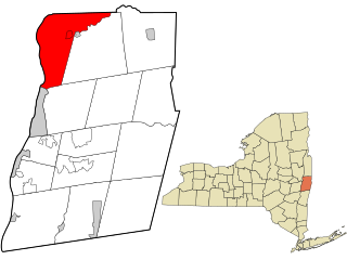
Clinton County is a county in the north-easternmost corner of the state of New York, in the United States and bordered by the Canadian province of Quebec. As of the 2020 United States Census, the population was 79,843. Its county seat is the city of Plattsburgh. The county lies just south of the border with the Canadian province of Quebec and to the west of the State of Vermont.
Rensselaer County is a county in the U.S. state of New York. As of the 2020 census, the population was 161,130. Its county seat is Troy. The county is named in honor of the family of Kiliaen van Rensselaer, the original Dutch owner of the land in the area.

Madison County is a county located in the U.S. state of New York. As of the 2020 census, the population was 68,016. Its county seat is Wampsville. The county is named after James Madison, the fourth president of the United States, and was first formed in 1806.

Saratoga County is a county in the U.S. state of New York, and is the fastest-growing county in Upstate New York. As of the 2020 U.S. census, the county's population was enumerated at 235,509, its highest decennial count ever and a 7.2% increase from the 219,607 recorded at the 2010 census, representing one of the fastest growth rates in the northeastern United States; and despite the worldwide toll of the COVID-19 pandemic in the early 2020s, Saratoga County has continued its rapid growth. The county seat is Ballston Spa. Saratoga County is included in the Capital District, encompassing the Albany-Schenectady-Troy, New York Metropolitan Statistical Area.

Grand Isle County is a county in the U.S. state of Vermont. As of the 2020 census, the population was 7,293, making it Vermont's second-least populous county. Its shire town is North Hero. The county was created in 1802 and organized in 1805.

St. Lawrence County is a county in the U.S. state of New York. As of the 2020 census, the population was 108,505. The county seat is Canton. The county is named for the Saint Lawrence River, which in turn was named for the Christian saint Lawrence of Rome, on whose feast day the river was visited by French explorer Jacques Cartier.

Hoosick is a town in Rensselaer County, New York, United States. The population was 6,711 at the 2020 census. It was named from the Hoosic River.

North Greenbush is a town in Rensselaer County, New York, United States. North Greenbush is located in the western part of the county. The population was 13,292 at the 2020 census.

Petersburgh is a town located in the northeast section of Rensselaer County, New York, United States. The population was 1,372 at the 2020 census. The town was named after an early settler named Peter Simmons.

Rensselaer is a city in Rensselaer County, New York, United States, and is located on the east side of the Hudson River, directly opposite of Albany. As of the 2020 census, the city population was 9,210. Rensselaer is on the western border of Rensselaer County. The area now known as the City of Rensselaer was settled by the Dutch in the 17th century, who called it t'Greyn Bos, which became Greenbush in English. The city has a rich industrial history stretching back to the 19th century, when it became a major railroad hub; in 2020, Albany-Rensselaer was the ninth busiest Amtrak station in the country and the second busiest in New York State. Rensselaer was one of the earliest locations of the dye industry in the United States, and was the first American location for the production of aspirin.

Schodack is a town in Rensselaer County, New York, United States. The population was 12,965 at the 2020 census. The town name is derived from the Mahican word, Escotak. The town is in the southwestern part of the county. Schodack is southeast of Albany, New York.

East Greenbush is a town in Rensselaer County, New York, United States. It is a suburb of Albany. The population was 16,748 at the 2020 census. The word Greenbush is derived from the Dutch het groen bosch, referring to the pine woods that originally covered the land. The first settlement of the land now known as East Greenbush was made by tenants under patroon Kiliaen van Rensselaer circa 1630. The town was established in 1855 as Clinton, and was renamed in 1858. It is mostly suburban along its major highways and rural in the southwestern and northeastern corners.
SchaghticokeSKAT-i-kohk is a town in Rensselaer County, New York, United States. The population was 7,445 at the 2020 census. It was named for the Schaghticoke, a Native American tribe formed in the seventeenth century from an amalgamation of remnant peoples of eastern New York and New England. The tribe has one of the oldest reservations in the United States, located in what is now Litchfield County, Connecticut. It has been recognized by the state of Connecticut but has not yet achieved federal recognition.

New York State Route 22 (NY 22) is a north–south state highway that parallels the eastern border of the U.S. state of New York, from the outskirts of New York City to the hamlet of Mooers in Clinton County near the Canadian border. At 337 miles (542 km), it is the state's longest north–south route and the third longest state route overall, after NY 5 and NY 17. Many of the state's major east–west roads intersect with, and often join, NY 22 just before crossing into the neighboring New England states, where U.S. Route 7 (US 7), which originally partially followed NY 22's alignment, similarly parallels the New York state line.
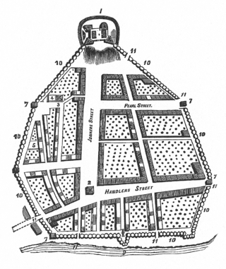
The streets of Albany, New York have had a long history going back almost 400 years. Many of the streets have changed names over the course of time, some have changed names many times. Some streets no longer exist, others have changed course. Some roads existed only on paper. The oldest streets were haphazardly laid out with no overall plan until Simeon De Witt's 1794 street grid plan. The plan had two grids, one west of Eagle Street and the old stockade, and another for the Pastures District south of the old stockade.
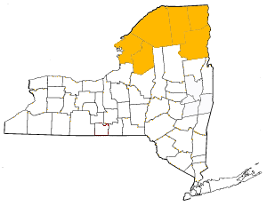
The towns and cities of New York's North Country were created by the U.S. state of New York as municipalities in order to give residents more direct say over local government. The North Country consists of Clinton County, Essex County, Franklin County, Jefferson County, Lewis County, and St. Lawrence County. When counties were first formed in 1683 the entire area was theoretically under the jurisdiction of Albany County though actually wilderness inhabited by Native Americans, by 1764 most of the area became effectively controlled by Albany County. The state would sell off this land to settlers and speculators, most notably as part of the Old Military Tract (1786) to veterans of the US Revolutionary War and as Macomb's Purchase (1791) to Alexander Macomb. In 1772 the northern and western portions of Albany County was divided into two counties– Tryon and Charlotte. Tryon encompassed Lewis, Jefferson, and St. Lawrence counties along with the western section of Franklin; Tryon was renamed Montgomery in 1784. Charlotte encompassed Clinton, Essex, and the majority of Franklin County; the name of the county was changed to Washington County in 1784. In 1788 Clinton County was split from Washington, Essex was formed from Clinton in 1799 and Franklin was formed from Clinton in 1808. Montgomery County's North Country area went to Herkimer County on that county's formation in 1791, but western Franklin and eastern St. Lawrence were returned to Montgomery in 1797. In 1798 Lewis, Jefferson, and western St. Lawrence became part of the newly formed Oneida County from Herkimer in 1798, leaving only central St. Lawrence County as part of Herkimer. In 1801 the future St. Lawrence and Franklin counties which were portions of Montgomery, Herkimer, and Oneida were transferred to Clinton County; the next year in 1802 St. Lawrence was formed as a county. In 1805 both Lewis and Jefferson counties were formed from Oneida County.
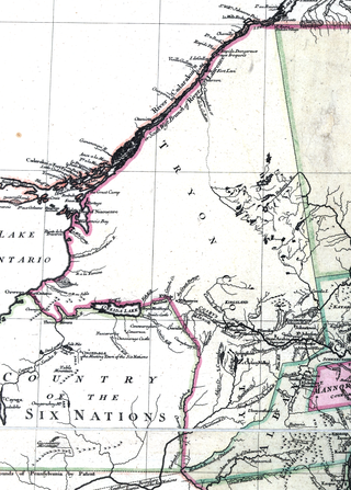
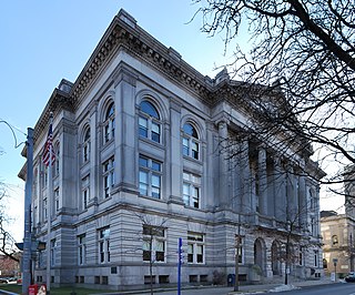
Tryon County was a county in the colonial Province of New York in the British American colonies. It was created from Albany County on March 24, 1772, and was named for William Tryon, the last provincial governor of New York. The county's boundaries extended much further than any current county. Its eastern boundary with the also-new Charlotte County ran "from the Mohawk River to the Canada line, at a point near the old village of St. Regis and passing south to the Mohawk between Schenectady and Albany." It extended north to the St. Lawrence River; its western boundary was the Treaty of Fort Stanwix's Line of Property, following the Unadilla River, Oneida Lake, Onondaga River and Oswego River to Lake Ontario, as the Iroquois Confederacy still controlled locations further west in the Indian Reserve. Tryon County's seat was Johnstown, which is today the county seat of Fulton County. The Tryon County Courthouse, built in 1772–1773, was listed on the National Register of Historic Places in 1972. The Tryon County Jail, also built in 1772–1773, was listed on the National Register of Historic Places in 1981.

The 14th New York State Legislature, consisting of the New York State Senate and the New York State Assembly, met from January 5 to March 24, 1791, during the fourteenth year of George Clinton's governorship, in New York City.
