Related Research Articles

The Delaware Aqueduct is an aqueduct in the New York City water supply system. It takes water from the Rondout, Cannonsville, Neversink, and Pepacton reservoirs on the west bank of the Hudson River through the Chelsea Pump Station, then into the West Branch, Kensico, and Hillview reservoirs on the east bank, ending in at Hillview in Yonkers, New York.

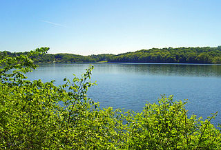
The West Branch Reservoir is a reservoir in the New York City water supply system. Formed by impounding the upper reaches of the West Branch of the Croton River, it is located in the Putnam County, New York, towns of Kent, New York, and Carmel, New York, about 50 miles (80 km) north of New York City.

The Boyds Corner Reservoir is a small reservoir in Putnam County, New York. It is in the town of Kent, New York, and is about 50 miles north of New York City. It is the northernmost reservoir in the Croton River watershed, but is not part of the New York City water supply system's Croton Watershed. and was formed by impounding the middle of the West Branch of the Croton River, submerging the village of Boyds Corner.

The Cross River Reservoir is a reservoir in the New York City water supply system located directly east and north of the northern Westchester County, New York, Hamlet of Katonah. Part of the system's Croton Watershed, it lies within the towns of Bedford, Lewisboro, and Pound Ridge, about 1 mile (1.6 km) east of the village of Katonah, and over 25 mi (40 km) north of New York City. It was constructed around the start of the 20th century by impounding the Cross River, a tributary of the Croton River, which eventually flows into the Hudson River.
The Croton Falls Reservoir is a reservoir in the New York City water supply system in the Putnam County, New York townships of Carmel, and Southeast, roughly 50 miles (80 km) north of New York City. Part of the system's Croton Watershed, it was formed by impounding the West Branch and Middle Branch of the Croton River, tributaries of the Croton River, which flows into the Hudson River.
The Diverting Reservoir is a reservoir in the New York City water supply system in the town of Southeast, New York, in Putnam County immediately south of the village of Brewster, New York. Part of the system's Croton Watershed, it lies about 50 miles (80 km) north of New York City. Construction impounding the East Branch Croton River began early in the 20th century and was completed by 1911.

The Muscoot Reservoir is a reservoir in the New York City water supply system in northern Westchester County, New York, located directly north of the village of Katonah. Part of the system's Croton Watershed, it is 25 miles north of the City. It was constructed at the beginning of the 19th century by impounding the Muscoot River, a tributary of the Croton River, in turn a tributary of the Hudson River.

The Croton River is a river in southern New York with three principal tributaries: the West Branch, Middle Branch, and East Branch. Their waters, all part of the New York City water supply system, join downstream from the Croton Falls Reservoir. Together, their waters and the reservoirs linked to them represent the northern half of the New York City water system's Croton Watershed.

Lake Gilead is a 116-acre (0.47 km2) reservoir located in Carmel Hamlet in Putnam County, New York. Originally known as Dean's Pond, it is 0.8 miles long, has a mean depth of 43 feet (13 m), and a maximum depth of approximately 120 feet (37 m). The lake is located within the lower Hudson River basin in the Croton River watershed.

The New Croton Aqueduct is an aqueduct in the New York City water supply system in Westchester County, New York carrying the water of the Croton Watershed. Built roughly parallel to the Old Croton Aqueduct it originally augmented, it opened in 1910. The old aqueduct remained in service until 1955, when supply from the Delaware and Catskill Aqueducts was sufficient to take it off line.
Lake Gleneida is a reservoir in the hamlet of Carmel within the Town of Carmel in central Putnam County, New York. Originally a smaller natural water body, Shaw's Pond, it was dammed by New York City in 1870 and enlarged to 168 acres (68 ha) for inclusion in its water supply system. It is classified as a controlled lake by the City system, and is part of its Croton Watershed.

The Titicus River is an 8.5-mile-long (13.7 km) river in southwestern Connecticut and southeastern New York that drains into the Titicus Reservoir, part of New York City's water supply system. Part of both the Croton River watershed and the system's Croton Watershed, has a 23.8 square miles (62 km2) drainage area. It is one of the few rivers with headwaters in Connecticut that is part of the system. The source of the river is in Ridgefield, Connecticut. About one mile down stream, the stream marks the southern boundary of the Kiahs Brook Reserve. Another 0.5 miles downriver, it joins with Kiahs Brook, and then runs fairly close to Route 116. Once past the New York border, the Titicus River still runs close to New York 116 until emptying into the Titicus Reservoir. After the Titicus Reservoir, it runs another 0.5 miles, under I-684, and drains into the Muscoot Reservoir.
The East Branch Croton River is a tributary of the Croton River in Dutchess, Putnam, and Westchester counties in the state of New York. It lies within the Croton River watershed and is part of the New York City water supply system's Croton Watershed.

Lake Shenorock is a lake located in the hamlet of Shenorock in the town Somers, New York. The lake is used for fishing and was used for recreational swimming until the Clean Water Act was passed and the lake became a source of drinking water. The Clean Water Act was passed in 1972, recreational swimming ended in 1977. The lake is part of the Croton Reservoir System and is a tributary to the Amawalk Reservoir, which is used as a source of water for New York City residents. There are no major tributaries to the class B lake.
The Kirk Lake is a reservoir in the hamlet of Mahopac in the town of Carmel in Putnam County, New York. It lies due west and sharply below considerably larger Lake Mahopac. It is one of three controlled lakes in the New York City water supply system's Croton Watershed.
This page is about a component of the New York City water supply system. For the hydrological feature with a similar name, see Croton River watershed
This page is about the Croton River watershed, a hydrological feature. For the component of the New York City water supply system with a similar name, see Croton Watershed
The West Branch Croton River is a tributary of the Croton River in Putnam and Westchester counties in the state of New York. It lies within the Croton River watershed and is part of the New York City water supply system's Croton Watershed.
The Middle Branch Croton River is a tributary of the Croton River in Putnam and Westchester counties in the state of New York. It lies within the Croton River watershed and is part of the New York City water supply system's Croton Watershed.
The Muscoot River is a short tributary of the Croton River in Putnam and Westchester counties in the state of New York. Approximately 6 mi (9.7 km) long and running north-to-south, it lies within the Croton River watershed and is part of the New York City water supply system's Croton Watershed.
References
Coordinates: 41°16′06″N73°42′05″W / 41.26833°N 73.70139°W [1]
| This article about a location in Westchester County, New York is a stub. You can help Wikipedia by expanding it. |
| This article related to a river in New York is a stub. You can help Wikipedia by expanding it. |