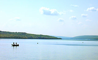
Owasco Lake is the sixth largest and third easternmost of the Finger Lakes of New York in the United States.

Hemlock Lake is one of the minor Finger Lakes. It is mostly located in Livingston County, New York, south of Rochester, with a portion overlapping into Ontario County. Hemlock is a translation of the Seneca name for the lake, O-neh-da Te-car-ne-o-di.
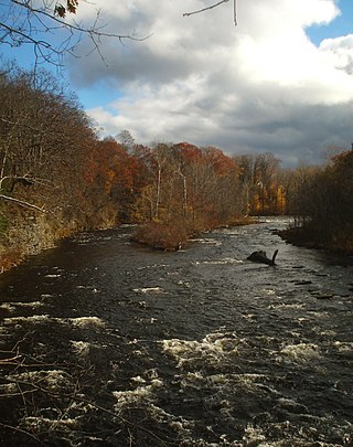
The Salmon River is a small river north of Syracuse in Upstate New York, the United States. It is a popular and economically important sportfishing destination, and the most heavily fished of New York's Lake Ontario tributaries. From its headwaters in the Tug Hill region of New York, it flows 44 miles (71 km) westward through two hydroelectric dams and over the 110-foot (34 m) Salmon River Falls before it empties into eastern Lake Ontario at Port Ontario in Oswego County. The Salmon River watershed drains approximately 280 square miles (730 km2).
Star Lake is located by Star Lake, New York. Fish species present in the lake are largemouth bass, smallmouth bass, rainbow trout, landlocked salmon, brown trout, white sucker, sunfish, rock bass, yellow perch, and black bullhead. There is carry-down launch access with permission from the Town of Fine, on route 3.
Lake Ozonia is a lake located by Lake Ozonia, New York, St. Lawrence county in the Adirondacks in upstate New York. The outlet of the lake is Lake Ozonia Outlet which flows into the St. Regis River.
Lake Moraine is a mesotrophic lake located 2.5 miles (4.0 km) northeast of Hamilton, New York. The lake is 261 acres (1.06 km2), consisting of two basins which are separated by a causeway and interconnected by a culvert. The northern basin is 79 acres (0.32 km2) and is relatively shallow with a maximum depth of 12 feet (3.7 m) and average depth of 3.7 feet (1.1 m). The larger southern basin is 172 acres (0.70 km2) and has a maximum depth of 45 feet (14 m) and an average depth of 17.7 feet (5.4 m). Payne Brook is the lake's outflow that flows into the Chenango River.
East Caroga Lake is located in the Town of Caroga by Caroga Lake, New York. The lake provides excellent warm water fishing and rainbow trout fishing. The lake is connected to West Caroga Lake by a small channel. Origin of the name, "Caroga" is derived from the once nearby Indian Village known as "Caroga".

Canada Lake is a lake located in the Town of Caroga in Fulton County in the U.S. State of New York. Unlike the nearby Caroga lakes, Canada Lake is very deep which provides colder water for species such as trout to survive. There is an annual draw down on the lake by way of a control structure on the outlet of Stewart Landing. The impoundment of this water has created a lake complex of Lily Lake, Canada Lake, West Lake and Green Lake.
Lake of the Woods is a lake located by Chapel Corners, New York. The outlet flows into the Indian River. Fish species present in the lake are northern pike, lake trout, black crappie, smallmouth bass, rainbow trout, landlocked salmon, whitefish, yellow perch, rock bass, and bluegill. There is a state-owned beach launch on the lake off Cottage Hill Road and there is a 10 horsepower limit.
Witchhopple Lake is a lake located by Keepawa, New York. The outlet flows into Salmon Lake and then from there into Stillwater Reservoir. Fish species present in Witchhopple Lake are brook trout, white sucker, sunfish, yellow perch, and splake. Access by trail from the north shore of Stillwater Reservoir. No motors are allowed on Witchhopple Lake. There is a trail that goes from Witchhopple Lake to Negro Lake called Bushwhack Trail.
Lake Rondaxe is a lake located northeast of Carter Station, New York. Fish species present in the lake are Atlantic salmon, rainbow trout, smallmouth bass, brook trout, yellow perch, and black bullhead. There is no public access.
Sylvia Lake is a lake located by Balmat, New York. Fish species present in the lake are largemouth bass, smallmouth bass, lake trout, rainbow trout, landlocked salmon, and black bullhead. There is a state owned beach launch on Route 812 between Fowler and Balmat.
Lake Eaton is a lake located west of Long Lake, New York. Fish species present in the lake are brook trout, lake trout, lake whitefish, smallmouth bass, landlocked salmon, brown trout, and rainbow trout. There is a state owned beach launch located in the campground on Route 30, 2 miles west of Long Lake.
South Pond is a lake located south of Deerland, New York. Fish species present in the lake are brook trout, lake trout, splake, smallmouth bass, landlocked salmon, black bullhead, and yellow perch. There is a carry down launch located on NY-30 on the northeast shore.
Sixth Lake is a lake located by Inlet, New York. It is part of the Fulton Chain Lakes. The inlet is connected to Seventh Lake by a channel and the outlet is connected to Fifth Lake by a creek. Fish species present in the lake are brown trout, lake whitefish, lake trout, smelt, splake, rainbow trout, white sucker, black bullhead, yellow perch, and pumpkinseed sunfish. There is access via a channel from Seventh Lake.
Trout Lake is located west of Bolton, New York. Fish species present in the lake are brook trout, rainbow trout, splake, lake trout, smallmouth bass, largemouth bass, pickerel, yellow perch, smelt, rock bass, rainbow smelt, brown trout and brown bullhead. There is a carry down trail on the northeast shore via trail off Lamb Hill Road. There is a 50 horsepower motor limit on this lake. It is called Trout Lake due to the high numbers of lake trout and rainbow trout that are found in the lake. It is also shaped like a trout.
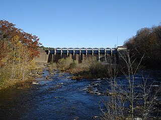
Salmon River Reservoir, also known as the Redfield Reservoir, is a man-made lake located near the hamlet of Redfield, New York. The reservoir was created with the completion of a hydroelectric dam in 1912. It has the capacity to hold 56,000 acre-feet (69,000,000 m3) of water. It is the larger of the Salmon River's two reservoirs.
Taylor Pond is a lake located in Clinton County, New York in the Adirondack Park. It is located within, and is the namesake of, the Taylor Pond Wild Forest. The lake has public access via a DEC campground, which includes a beach ramp boat launch. Taylor Pond is surrounded by public land, with no camps located on the lake.
Sterling Lake is a lake located in Sterling Forest State Park, New York. The lake contains a number of fish species including Lake Trout, Largemouth Bass, Smallmouth Bass, Chain Pickerel and Panfish. Fishing is permitted from the shore only; no boating is allowed on the lake, and the use of bait-fish is prohibited. There are a number of scenic hiking trails around the lake. One of the trails leads to the Sterling Mountain Fire Observation Tower and Observer's Cabin which provides a 360 degree view of the forest, including Sterling Lake.
Blue Lake, also called Sterling Forest Lake, is a lake located in Sterling Forest State Park, New York. As of 2018, the Blue Lake Reservoir System, operated by SUEZ North America, supplies drinking water from Blue Lake to about 1,200 people.

