Clifton Park, New York

Last updated

Clifton Park
Shenendehowa (Mohawk)
Town of Clifton Park
Clifton Park Rest Area.jpg
The town's rest area on I-87
Clifton Park Saratoga NY.png
Location within Saratoga County
USA New York location map.svg
Red pog.svg
Clifton Park
Location within the state of New York
Usa edcp location map.svg
Red pog.svg
Clifton Park
Clifton Park (the United States)
Coordinates: 42°52′N73°49′W / 42.867°N 73.817°W / 42.867; -73.817
CountryUnited States
State New York
County Saratoga
Area
[1]
  Total50.21 sq mi (130.03 km2)
  Land48.20 sq mi (124.84 km2)
  Water2.00 sq mi (5.19 km2)
Elevation
318 ft (97 m)
Population
 (2020) [2]
  Total38,029
  Density762.52/sq mi (294.41/km2)
Time zone UTC-5 (Eastern (EST))
  Summer (DST) UTC-4 (EDT)
ZIP code
12065
Area code 518
FIPS code 36-16353
GNIS feature ID0978839
Website www.cliftonpark.org

Clifton Park is a suburban town in Saratoga County, New York, United States. It is the largest municipality in the county, with a 2020 population of 38,029, according to the 2020 census. The name is derived from an early land patent. [3] The town is in the southern part of Saratoga County, approximately 12 miles (19 km) north of Albany, 7 miles (11 km) northeast of Schenectady, and 10 miles (16 km) south of Saratoga Springs.

Contents

History

The Indigenous Mohawks and Mohicans referred to the area as Canastigione, meaning corn flats. [4] [5] The first settlements in what is now Clifton Park were established in the 17th century. [6] The town or area was named in 1707 by Nanning Harmansen. [7] At that time, Nanning Harmansen sent letters to Lord Cornbury requesting letters of Patent for Land he bought from the Indigenous Americans. [8] [7] He also stated in this correspondence that he wanted the patent to be known by "Your name of Cliftons Park", and the patent was named the Clifton Park Patent. The Iroqouis name for the Clifton Park Patent was Shenendehowa [9] (meaning "Great Plains") [10] which is where the school district derives gets its name. [11]

The area along the Mohawk River was popular for ferries across the waterbed, with Eldert Vischer opening the crossing known as Vischer Ferry in 1783. To the northwest, Edward Rexford established Rexford Flats, a small community on the riverbank at the northern end of what became NY 146B. [6]

In 1828, the town of Clifton Park was created as "Clifton" from the town of Halfmoon, but was renamed Clifton Park a year later. [6] It was the last town created in Saratoga County. The town originally consisted of farmland with a small village of homes, churches and businesses on what is now U.S. Route 9, but saw a large demographic change when Interstate 87 was built through the town in 1961. [12]

The Grooms Tavern Complex was listed on the National Register of Historic Places in 2000. [13] The Mohawk Valley Grange Hall was added in 2012.

Geography

According to the United States Census Bureau, the town has a total area of 50.2 square miles (130 km2), of which 48.6 square miles (126 km2) is land and 1.6 square miles (4.1 km2) (3.29%) is water.

The town's southern boundary is defined by the Mohawk River and is the border between Saratoga County and Schenectady and Albany counties.

Interstate 87 (the "Adirondack Northway") and U.S. Route 9 pass through the eastern part of the town. New York State Route 146 is an east–west highway through most of the center of Clifton Park until it takes a 90 degree turn southward, passing east of the hamlet of Rexford and then crossing the Rexford bridge into the Town of Niskayuna in Schenectady County.

Demographics

Historical population
CensusPop.Note
1830 2,494
1840 2,7199.0%
1850 2,8685.5%
1860 2,804−2.2%
1870 2,657−5.2%
1880 2,454−7.6%
1890 2,228−9.2%
1900 2,140−3.9%
1910 2,2254.0%
1920 1,983−10.9%
1930 2,22212.1%
1940 2,2531.4%
1950 3,28145.6%
1960 4,51237.5%
1970 14,867229.5%
1980 23,98961.4%
1990 30,11725.5%
2000 32,9959.6%
2010 36,70511.2%
2020 38,0293.6%
U.S. Decennial Census [2]

As of the census [14] of 2008, there were over 37,707 people, 13,782 households, and 10,077 families residing in the town. There were 14,262 housing units. The racial makeup of the town was 92.2% White, 2.0% African American, 0.02% Native American, 3.4% Asian, 0.02% Pacific Islander, 0.36% from other races, and 1.6% from two or more races.

There were 13,782 households, out of which 35.7% had children under the age of 18 living with them, 63.8% were married couples living together, 6.2% had a female householder with no husband present, and 26.9% were non-families. 21.8% of all households were made up of individuals, and 6.8% had someone living alone who was 65 years of age or older. The average household size was 2.73 and the average family size was 3.23.

In the town, the age distribution of the population shows 27% under the age of 20, 5.5% from 20 to 24, 15.9% from 25 to 44, 26.1% from 45 to 64, and 12.3% who were 65 years of age or older. The median age was 38.2 years. For 18 and older, there were 49.2% males and 50.8% females.

The median income for a household in the town was $82,850, and the median income for a family was $98,275. Males had a median income of $68,417 versus $46,948 for females. The per capita income for the town was $37,405. About 1.4% of families and 2.9% of the population were below the poverty line, including 2.9% of those under age 18 and 2.8% of those age 65 or over.

Recreation

There are many opportunities for youth involvement in typical sports teams such as football, baseball, softball, lacrosse, soccer, basketball, wrestling and hockey. Adults may participate as well. Every year Clifton Park Soccer Club hosts an international tournament called the Rose and Kiernan/Clifton Park Soccer International Soccer Classic.

Clifton Park also periodically hosts the Babe Ruth World Series for boys baseball. There are also other annual events, such as Winterfest.

Clifton Common which is located on Vischer Ferry Rd. is a central hub for recreation which features baseball/softball fields, soccer fields, outdoor basketball courts, two NHL-size ice rinks, playgrounds, and an outdoor stage for performing arts. [15]

The Vischer Ferry Nature and Historic Preserve, a 740-acre site in southern Clifton Park adjacent to the Mohawk River, features a network of walking trails alongside an original section of the Erie Canal and towpath.

Schools

The public school district covering most (the eastern two-thirds) of Clifton Park is the Shenendehowa Central School District, located on NY Route 146. In addition, the Burnt Hills-Ballston Lake Central School District and the Niskayuna Central School District cover the northwest and southwest corners of Clifton Park respectively.

The Shenendehowa Central Schools main campus covers about 232 acres (0.94 km2) of property along the south side of NY Route 146. With a student body of over 9,800 students in eight elementary schools, three middle schools, and two high schools, Shenendehowa Central Schools is one of the largest school districts in New York State. Shenendehowa Central Schools' achievements include twenty-two New York State Championship titles for their Men's Soccer team as well as two National Championships. Their Cross Country team has won six NYS Federation Men's Cross Country Championships.[ citation needed ]

Shenendehowa schools:

Elementary schools: Karigon and Orenda (connected), Tesago and Skano (connected), Okte, Chango, Arongen, and the newest addition, Shatekon

Middle schools (all connected): Gowana, Acadia, Koda

High schools: High School West (9th grade only) and High School East (10-12 grades only)

Although there are two different high schools, they are allowed to participate in the same clubs and events (with few exceptions, such as dances and activities during school hours.)

Communities and locations in Clifton Park

Notable people

See also

Related Research Articles

<span class="mw-page-title-main">Saratoga County, New York</span> County in New York, United States

Saratoga County is a county in the U.S. state of New York, and is the fastest-growing county in Upstate New York. As of the 2020 U.S. census, the county's population was enumerated at 235,509, its highest decennial count ever and a 7.2% increase from the 219,607 recorded at the 2010 census, representing one of the fastest growth rates in the northeastern United States; and despite the worldwide toll of the COVID-19 pandemic in the early 2020s, Saratoga County has continued its rapid growth. The county seat is Ballston Spa. The county is part of the Capital District region of the state.

<span class="mw-page-title-main">Ballston, New York</span> Town in New York, United States

Ballston is a town in Saratoga County, New York, United States. The population was 11,831 at the 2020 census. The name is derived from an early settler, Eliphalet Ball, a Presbyterian minister who relocated there from Westchester County, New York in 1770. The town is in the southern part of the county, and is north of Schenectady.

<span class="mw-page-title-main">Halfmoon, New York</span> Town in New York, United States

Halfmoon is a town in Saratoga County, New York, United States. The population was 25,662 at the 2020 census. The town is apparently named for the shape of the lower elevation land north of the junction of the Hudson and Mohawk Rivers. It is also said to be named for Henry Hudson's ship, the Halve Maen.

<span class="mw-page-title-main">Malta, New York</span> Town in New York, United States

Malta is a town in Saratoga County, New York, United States. The town is in the central part of the county and is south of Saratoga Springs. The population was 17,130 as of the 2020 census.

<span class="mw-page-title-main">Glenville, New York</span> Town in New York, United States

Glenville is a town in Schenectady County, New York, United States. It was incorporated in 1821 from Schenectady. As of the 2020 census, the town population was 29,326.

<span class="mw-page-title-main">Colonie, New York</span> Town in New York, United States

Colonie is a town in Albany County, New York, United States. It is the most-populous suburb of Albany, and is the third-largest town in area in Albany County, occupying approximately 11% of the county. Several hamlets exist within the town. As of the 2020 census, the town had a total population of 85,590.

<span class="mw-page-title-main">Niskayuna, New York</span> Town in New York, United States

Niskayuna is a town in Schenectady County, New York, United States. The population was 23,278 at the 2020 census. The town is located in the southeast part of the county, east of the city of Schenectady, and is the easternmost town in the county.

Alplaus is a hamlet located in Schenectady County, New York, United States. Its name is derived from the Dutch Aal Plaats, or "Place of the Eels."

The Shenendehowa Central School District, often shortened to Shen, is a public school district located in New York's Capital District. The district's 232-acre (0.94 km2) main campus is located off NY 146 in Clifton Park, and is home to eight of the district's 12 schools, in five buildings. The remaining four schools are called "neighborhood elementary schools" and are located throughout the district in three buildings. The district serves approximately 9,500 students in grades K-12 from throughout its 86-square-mile (220 km2) territory which includes the towns of Clifton Park, Halfmoon, Ballston Lake, Round Lake, Malta and parts of Waterford, Rexford, Mechanicville and Stillwater. Shenendehowa is the largest School District in Saratoga County, and the largest in student population in the Suburban Council, an interscholastic athletic consortium of 11 area school with a districts.

<span class="mw-page-title-main">Area codes 518 and 838</span> Telephone area codes for Upstate New York, U.S.

Area codes 518 and 838 are telephone area codes in the North American Numbering Plan for eastern Upstate New York in the United States. 518 is one of the 86 original North American area codes created in 1947. Area code 838 was added to the 518 numbering plan area in 2017. The two area codes serve 24 counties and 1,200 ZIP Code areas in a numbering plan area (NPA) that extends from the eastern Mohawk Valley to the Vermont border, and from the Canada–US border to south of Albany. The bulk of the population is in the Capital District, the vicinity of the cities Albany, Schenectady, and Troy. Other cities in the NPA are Glens Falls, Plattsburgh, and Saratoga Springs. It includes the Upper Hudson Valley counties, Greene and Columbia counties, and some northern parts of Dutchess County.

Rexford is a hamlet in Saratoga County, New York, United States, located on the north bank of the Mohawk River. Rexford is in the Town of Clifton Park, near the southwestern town line. Its boundaries, like those of neighboring Alplaus, are unofficial and necessarily ambiguous. To the south, it is bounded by the Mohawk River and Grooms Road and to the west, Alplaus and the Schenectady County line. Route 146 and Vischer's Ferry Road, are probably a reasonable delineations of its northern and eastern boundaries. The ZIP Code is 12148.

<span class="mw-page-title-main">New York State Route 146</span> State highway in New York, US

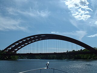
New York State Route 146 (NY 146) is a state highway in the Capital District of New York in the United States. It extends for 43 miles (69 km) from Gallupville at NY 443 to near Mechanicville at U.S. Route 4 (US 4) and NY 32. NY 146 is a major thoroughfare in the city of Schenectady, just outside Albany. Most of the route follows an east–west alignment; however, the middle third of the route between Guilderland and Clifton Park runs in a more north–south manner in order to serve Schenectady. At one time, NY 146 had three spur routes; only one—NY 146A—still exists.

<span class="mw-page-title-main">New York State Route 146A</span> State highway in Saratoga County, New York, US

New York State Route 146A (NY 146A) is a state highway in New York State. It begins at NY 146 in Clifton Park and ends at NY 50 in Ballston Lake. It is located entirely within Saratoga County. Route 146A is the last existing spur of NY 146 in Saratoga and Schenectady counties.

<span class="mw-page-title-main">New York State Route 146B</span> Highway in New York

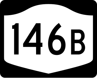
New York State Route 146B (NY 146B) was a state highway in southern Saratoga County, New York, in the United States. It was 3 miles (4.8 km) long and located entirely within the town of Clifton Park. The western terminus of the route was at an intersection with NY 146, its parent route, in the hamlet of Rexford. The eastern terminus of NY 146B was in the hamlet of Groom Corners, where it met Miller and Sugarhill roads. NY 146B was assigned c. 1932 and removed c. 1965. Its former routing is now the western portion of County Route 91 (CR 91).

The Niskayuna Central School District is a public school district located in Niskayuna, New York. It has a total enrollment of 4,312 students in grades K–12 in 8 schools. The district superintendent was Susan Kay Salvaggio until 2014. After that, Dr. Cosimo Tangorra became the superintendent and is the current superintendent. Then Until Salvaggio was superintendent Kevin. S. Baughman held the prestigious note of being the second-highest school administrator in the State of NY, making over $200,000, nearly double the salary of the Governor. The district primarily serves the Town of Niskayuna, but also covers a small section of the Town of Colonie, the Alplaus area of the Town of Glenville and the Rexford area of the Town of Clifton Park, both north of the Mohawk River.

<span class="mw-page-title-main">Mohawk Towpath Scenic Byway</span>

The Mohawk Towpath Scenic Byway is a National Scenic Byway in the Capital District region of New York in the United States. It extends from Schenectady to Waterford by way of a series of local, county, and state highways along the Mohawk River and the Erie Canal. The byway is intended to showcase the history of the waterway, from Native American times through the creation of the Erie Canal and the role the waterside communities played in the Industrial Revolution and the westward expansion of the United States. At its east end, the byway connects to the Lakes to Locks Passage, an All-American Road.

<span class="mw-page-title-main">Vischer Ferry, New York</span> Hamlet in New York, United States

Vischer Ferry is a hamlet in the town of Clifton Park in Saratoga County, New York, United States, along the Mohawk River.

Empire Orienteering Club (EMPO) was founded in 1987 to promote the sport of orienteering and develop suitable maps in the Capital District of New York State. The club was founded by Ed Downey, Ed Jaeger, Eric Hamilton and William Jameson during a meeting at the Guilderland, NY public library in the Spring of 1987. Today, EMPO organizes approximately 15 events per year, and has produced nearly 25 specialized, five color orienteering maps in the Albany, NY area. EMPO is a member of Orienteering USA.

<span class="mw-page-title-main">Aqueduct, New York</span> Hamlet in Niskayuna, Schenectady County, New York

Aqueduct is a hamlet in the Town of Niskayuna, Schenectady County, New York, United States. Its center is at the south end of the bridge of New York State Route 146 over the Mohawk River, that connects Schenectady County to the south and Saratoga County to the north. It was formerly a transportation hub. Alexander's Bridge across the Mohawk antedated the Aqueduct. A new Route 146 steel highway bridge, with board pavement, parallel to the Aqueduct was built in the early 20th century. A Schenectady trolley line ended there, the line also serving Luna Park, just over the river in Rexford. There was, in Aqueduct, a staffed station of the Troy & Schenectady Railroad, which operated from 1841 to 1932.

Clifton Knolls-Mill Creek is a census-designated place (CDP) within the town of Clifton Park, Saratoga County, New York, United States. It was first listed as a CDP prior to the 2020 census.

References

  1. "2016 U.S. Gazetteer Files". United States Census Bureau. Retrieved July 5, 2017.
  2. 1 2 U.S. Census, 2020, 'Clifton Park town, Saratoga County, New York'
  3. Bits and Pieces of Saratoga County History by Richard Dorrough, Ballston Journal
  4. "A Brief History Of Our Two Towns". Clifton Park-Halfmoon Public Library.
  5. "History Of Clifton Park". CliftonPark.com.
  6. 1 2 3 The Saratogian (1899). A Descriptive and Biographical Record of Saratoga County, New York. The Boston History Publishers Company.
  7. 1 2 "Bits and Pieces of Saratoga County History" by Richard Dorrough published in the Ballston Journal.[ full citation needed ]
  8. "How Clifton Park Got It's [sic] Name". New York Almanack. April 17, 2020.
  9. John L. Scherer (November 1, 1996). Clifton Park. Arcadia Publishing. pp. 166–. ISBN   978-1-4396-1982-7.
  10. "History of Logos". Shenendehowa Central Schools. Retrieved January 6, 2021.
  11. "Historical Information". Shenendehowa Central Schools. Retrieved January 6, 2021.
  12. Sunoco; H.M. Gousha Company (1961). New York and Metropolitan New York (Map) (1961–62 ed.). Sunoco.[ full citation needed ]
  13. 1 2 3 "National Register Information System". National Register of Historic Places . National Park Service. March 13, 2009.
  14. "U.S. Census website". United States Census Bureau . Retrieved January 31, 2008.
  15. "Explore Recreation & Entertainment at Clifton Common in Clifton Park".
  16. 1 2 3 4 5 6 Round Lake Digital Raster Quadrangle (Map). 1:24,000. New York State Department of Transportation. 1991. Retrieved January 21, 2010.
  17. 1 2 3 4 5 Niskayuna Digital Raster Quadrangle (Map). 1:24,000. New York State Department of Transportation. 1992. Retrieved January 21, 2010.
  18. "National Register of Historic Places Listings". Weekly List of Actions Taken on Properties: 5/07/12 through 5/11/12. National Park Service. May 18, 2012.
  19. "National Register of Historic Places Listings". Weekly List of Actions Taken on Properties: 4/02/12 through 4/06/12. National Park Service. April 13, 2012.
  20. Schenectady Digital Raster Quadrangle (Map). 1:24,000. New York State Department of Transportation. 1993. Retrieved January 21, 2010.