South Glens Falls, New York

Last updated

South Glens Falls
Village of South Glens Falls
Nickname(s): 
SGF, Southy[ citation needed ]
Village South Glens Falls NY Locator Map.png
Map highlighting South Glens Falls' location within Saratoga County.
USA New York location map.svg
Red pog.svg
South Glens Falls
Location within the state of New York
Coordinates: 43°17′47″N73°38′3″W / 43.29639°N 73.63417°W / 43.29639; -73.63417
Country United States
State New York
County Saratoga
Area
[1]
  Total1.49 sq mi (3.86 km2)
  Land1.36 sq mi (3.52 km2)
  Water0.13 sq mi (0.34 km2)
Elevation
344 ft (105 m)
Population
 (2020)
  Total3,744
  Density2,757.00/sq mi (1,064.15/km2)
Time zone UTC-5 (Eastern (EST))
  Summer (DST) UTC-4 (EDT)
ZIP code
12803
Area code 518
FIPS code 36-69078
GNIS feature ID0970626
Website www.sgfny.com

South Glens Falls is a village in Saratoga County, New York, United States. The population was 3,744 at the 2020 census. The village is in the northern part of the Town of Moreau, south of the City of Glens Falls.

Contents

Cooper's Cave, shown on the village seal, is named after the author, James Fenimore Cooper . Cooper was inspired to use the area as a location in his novel, The Last of The Mohicans , after visiting the area. [2]

History

In the late Woodland period , the area was considered to be the winter hunting grounds for the Mohawk and Algonquian tribes. Slowly, the area became attractive to settlement as good were transported through the "Great Carry" (now Route 9), between Glens Falls and Fort Edward. [3]

In 1766, the Daniel Parks family was the first family to settle into the area after receiving 800 acres (3.2 km2) of land, on which they built a house and a saw mill. By the mid-1830s, the settlement boasted saw mills, a grist mill, a cotton mill and a quarry as well as a dock to facilitate commerce. [3]

The Village was formally incorporated in 1895 as a result of an effort to form a public water system. [3]

The Historical Society of Moreau and South Glens Falls is housed in the Parks-Bentley House, added to the National Register of Historic Places in 1994. [4]

Education

South Glens Falls Central School District (SGFCSD) is registered by the New York State Department of Education and was chartered by the New York State Board of Regents in 1945. SGFCSD covers approximately 70 square miles (180 km2), serving the towns of Moreau, Northumberland and Wilton. It consists of four elementary schools (grades K-5), one middle school (grades 6-8) and one high school (grades 9-12). Total enrollment in the district is 3,350 students. Student-to-teacher ratio currently stands at 15:1, with more than half of the teaching staff having 20 years of classroom experience. Total per pupil costs are among the lowest in Saratoga County and is governed by a nine-member Board of Education. [5]

Elementary schools

Middle school

High school

South Glens Falls Central School District Website

South Glens Falls Senior High School, locally known as South High, is the host of the annual South High Marathon Dance, [6] where high school students raise money for families, individuals, or causes identified as in need. The inaugural event, in 1978, raised about $1500 for the local Emergency Squad. As of 2016, the Marathon Dance had raised a cumulative total of over $5.5 million for various causes, individuals, and families. [7]

Law and government

The Village is served by the South Glens Falls Police Department. [8]

The Village is governed by a Mayor and a four-person Village Board. [9]

Geography

South Glens Falls is located at 43°17′47″N73°38′3″W / 43.29639°N 73.63417°W / 43.29639; -73.63417 (43.296406, -73.634296). [10]

According to the United States Census Bureau, the village has a total area of 1.5 square miles (3.9 km2), of which 1.4 square miles (3.6 km2) is land and 0.1 square miles (0.26 km2) (9.40%) is water.

The village is located on the south bank of the Hudson River and is off exit 17N of Interstate 87.

U.S. Route 9, New York State Route 32 and County Road 28, all north-south highways, converge in the village.

Demographics

Historical population
CensusPop.Note
1870 1,047
1880 1,0833.4%
1890 1,60648.3%
1900 2,02526.1%
1910 2,24711.0%
1920 2,158−4.0%
1930 2,68924.6%
1940 3,08114.6%
1950 3,64518.3%
1960 4,12913.3%
1970 4,013−2.8%
1980 3,714−7.5%
1990 3,506−5.6%
2000 3,368−3.9%
2010 3,5184.5%
2020 3,7446.4%
U.S. Decennial Census [11]

As of the census [12] of 2000, there were 3,368 people, 1,523 households, and 851 families residing in the village. The population density was 2,500.6 inhabitants per square mile (965.5/km2). There were 1,616 housing units at an average density of 1,199.8 per square mile (463.2/km2). The racial makeup of the village was 98.52% White, 0.68% African American, 0.09% Native American, 0.15% Asian, 0.12% from other races, and 0.45% from two or more races. Hispanic or Latino of any race were 0.62% of the population.

There were 1,523 households, out of which 25.0% had children under the age of 18 living with them, 40.9% were married couples living together, 12.1% had a female householder with no husband present, and 44.1% were non-families. 36.6% of all households were made up of individuals, and 17.3% had someone living alone who was 65 years of age or older. The average household size was 2.20 and the average family size was 2.90.

In the village, the population was spread out, with 21.7% under the age of 18, 8.3% from 18 to 24, 30.5% from 25 to 44, 21.8% from 45 to 64, and 17.7% who were 65 years of age or older. The median age was 38 years. For every 100 females, there were 87.3 males. For every 100 females age 18 and over, there were 85.2 males.

The median income for a household in the village was $31,623, and the median income for a family was $41,694. Males had a median income of $31,757 versus $24,046 for females. The per capita income for the village was $17,260. About 8.3% of families and 10.6% of the population were below the poverty line, including 10.9% of those under age 18 and 13.0% of those age 65 or over.

Related Research Articles

<span class="mw-page-title-main">Morgan County, Missouri</span> County in Missouri, United States

Morgan County is a county located in the central portion of the U.S. state of Missouri. As of the 2020 census, the population was 21,006. Its county seat is Versailles. The county was organized January 5, 1833, and named for General Daniel Morgan of the American Revolutionary War.

<span class="mw-page-title-main">Ammon, Idaho</span> City in Idaho, United States

Ammon is a suburb city in Bonneville County, Idaho, United States. As of the 2010 US Census, the population of Ammon was 13,816. By the 2020 census, Ammon's population had grown to 17,694. It lies directly to the east of Idaho Falls and to the west of the Ammon foothills, and is the second most populous city in the Idaho Falls metropolitan area.

<span class="mw-page-title-main">Lansing, Illinois</span> Village in Illinois, United States

Lansing is a village in Cook County, Illinois, United States. Lansing is a south suburb of Chicago. The population was 29,076 at the 2020 census.

<span class="mw-page-title-main">Glendale Heights, Illinois</span> Village in Illinois, United States

Glendale Heights is a village in DuPage County, Illinois, United States. Per the 2020 census, the population was 33,176. The village is almost entirely residential, and is a far west suburb of Chicago.

<span class="mw-page-title-main">Sherrard, Illinois</span> Village in Illinois, United States

Sherrard is a village in Mercer County, Illinois, United States. The population was 692 at the 2020 census.

<span class="mw-page-title-main">Mamou, Louisiana</span> Town in Louisiana, United States

Mamou is a town in Evangeline Parish, Louisiana, United States. The population was 3,242 at the 2010 census, down from 3,566 in 2000.

<span class="mw-page-title-main">Jay, Maine</span> Town in the state of Maine, United States

Jay is a town in Franklin County, Maine, United States. Jay was included in the Lewiston-Auburn, Maine metropolitan New England city and town area. The population was 4,620 at the 2020 United States Census. Jay includes the village of Chisholm.

<span class="mw-page-title-main">Cannon Falls, Minnesota</span> City in Minnesota, Goodhue County, United States

Cannon Falls is a city in Goodhue County, Minnesota, United States. The population was 4,083 at the 2010 census. Located along U.S. Route 52, southeast of the Twin Cities, Cannon Falls is the home of Pachyderm Studio, where many famous musicians have recorded, including Nirvana, which recorded its 1993 album In Utero there.

<span class="mw-page-title-main">Williamsville, New York</span> Village in New York, United States

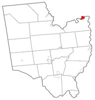
Williamsville is a village in Erie County, New York, United States. The population was 5,423 at the 2020 census. The village is named after Jonas Williams, an early settler. It is part of the Buffalo-Niagara Falls metropolitan area.

Port Leyden is a village in Lewis County, New York, United States. The population was 672 at the 2010 census. The name is derived from the village's early history as a port on the Black River Canal.

<span class="mw-page-title-main">Moreau, New York</span> Town in New York, United States

Moreau is a town in Saratoga County, New York, United States. The population was 16,202 at the 2020 census. The town is located in the northeast part of the county, north of Saratoga Springs. Moreau is named after Jean Victor Moreau, a French general, who visited the area just before the town was formed. The town contains a village called South Glens Falls.

<span class="mw-page-title-main">Clairton, Pennsylvania</span> City in Pennsylvania, United States

Clairton is a city in Allegheny County, Pennsylvania, United States. It is located along the Monongahela River and is part of the Pittsburgh metropolitan area. The population was 6,181 at the 2020 census. Under Pennsylvania legal classifications for local governments, Clairton is considered a third-class city. It is home to Clairton Works operated by U.S. Steel, the largest coke manufacturing facility in the United States.

<span class="mw-page-title-main">Brookside Village, Texas</span> City in Texas, United States

Brookside Village is a city in Brazoria County, Texas, United States. The population of the city was 1,548 at the 2020 U.S. census, an increase over the figure of 1,523 tabulated in the 2010 U.S. census. The city of Brookside Village is part of the Houston–The Woodlands–Sugar Land metropolitan statistical area.

<span class="mw-page-title-main">Palmview South, Texas</span> Census-designated place in Texas

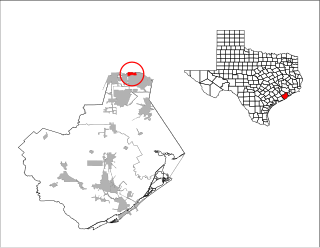
Palmview South is a census-designated place (CDP) in Hidalgo County, Texas, United States. The population was 5,575 at the 2010 United States Census. It is part of the McAllen–Edinburg–Mission Metropolitan Statistical Area.

<span class="mw-page-title-main">Great Falls, Virginia</span> Census-designated place in Virginia, United States

Great Falls is a census-designated place in Fairfax County, Virginia, United States. The population at the 2020 census was 15,953.

<span class="mw-page-title-main">Athens, Wisconsin</span> Village in Wisconsin, United States

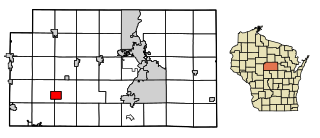
Athens is a village in Marathon County, Wisconsin, United States. The population was 1,105 at the 2010 census. It is part of the Wausau, Wisconsin Metropolitan Statistical Area.

<span class="mw-page-title-main">Stratford, Wisconsin</span> Village in Wisconsin, United States

Stratford is a village in Marathon County, Wisconsin, United States. It is part of the Wausau, Wisconsin Metropolitan Statistical Area. The population was 1,578 at the 2010 census.

<span class="mw-page-title-main">Oconto Falls, Wisconsin</span> City in Wisconsin, United States

Oconto Falls is a city in Oconto County, Wisconsin, United States. The population was 2,957 at the 2020 census. It is part of the Green Bay Metropolitan Statistical Area.

<span class="mw-page-title-main">River Falls, Wisconsin</span> City in Wisconsin, United States

River Falls is a city in Pierce and St. Croix counties in the U.S. state of Wisconsin. It is located mostly within the town of River Falls, and adjacent to the town of Kinnickinnic in St. Croix County. River Falls is the most populous city in Pierce County. The population was 16,182 at the 2020 census, with 12,546 residing in Pierce County and 3,636 in St. Croix County. It is part of the Minneapolis-St. Paul metropolitan area and located approximately 30 miles (48 km) east of the center of that region.

<span class="mw-page-title-main">Livermore Falls, Maine</span> Town in the state of Maine, United States

Livermore Falls is a town in Androscoggin County, Maine, United States. The population was 3,060 at the 2020 census. It is included in both the Lewiston-Auburn, Maine Metropolitan Statistical Area and the Lewiston-Auburn, Maine Metropolitan New England City and Town Area. High school students in Livermore Falls attend Spruce Mountain High School.

References

  1. "ArcGIS REST Services Directory". United States Census Bureau. Retrieved September 20, 2022.
  2. "James Fenimore Cooper Society Home Page".
  3. 1 2 3 http://www.sgfny.com/about-south-glens-falls-ny.htm#history [ dead link ]
  4. "National Register Information System". National Register of Historic Places . National Park Service. March 13, 2009.
  5. "South Glens Falls Central School District - District Information". Archived from the original on July 19, 2011. Retrieved July 25, 2010.
  6. "South High Marathon Dance | South Glens Falls New York". Archived from the original on February 8, 2012. Retrieved July 25, 2010.
  7. "South High Marathon Dance sets new record". March 7, 2016.
  8. "South Glens Falls Police Department". www.sgfny.com. Archived from the original on May 13, 2006.
  9. "Village Board | South Glens Falls, NY". www.sgfny.com. Archived from the original on May 13, 2006.
  10. "US Gazetteer files: 2010, 2000, and 1990". United States Census Bureau. February 12, 2011. Retrieved April 23, 2011.
  11. "Census of Population and Housing". Census.gov. Retrieved June 4, 2015.
  12. "U.S. Census website". United States Census Bureau . Retrieved January 31, 2008.