Galway (village), New York

Last updated

Galway
Village
Village of Galway
Village Galway NY Locator Map.png
Map highlighting Galway's location within Saratoga County.
USA New York location map.svg
Red pog.svg
Galway
Location within the state of New York
Coordinates: 43°1′0″N74°2′2″W / 43.01667°N 74.03389°W / 43.01667; -74.03389
Country United States
State New York
County Saratoga
Town Galway
Incorporated1838
Named for Galloway, Scotland
Area
[1]
  Total0.26 sq mi (0.66 km2)
  Land0.26 sq mi (0.66 km2)
  Water0.00 sq mi (0.00 km2)
Elevation
830 ft (253 m)
Population
 (2020)
  Total165
  Density644.53/sq mi (248.88/km2)
Time zone UTC-5 (Eastern (EST))
  Summer (DST) UTC-4 (EDT)
ZIP code
12074
Area code 518
FIPS code 36-28101
GNIS feature ID0950865

Galway is a village in the town of Galway in Saratoga County, New York, United States. The population was 200 at the 2010 census. [2] The village is north of Schenectady. Galway Lake, a vacation area, is west of the village.

Contents

History

The first settlers in the town established themselves south of Galway village.[ citation needed ]

In 1838, the village of Galway was incorporated. [3] The charter was amended in 1869.[ citation needed ]

Geography

According to the United States Census Bureau, the village has a total area of 0.3 square mile (0.7 km2), all land.

Galway is at the junction of County Road 45 (East Street/West Street) and New York State Route 147 (North Street/South Street) in the central part of the town.

Demographics

Historical population
CensusPop.Note
1880 187
1890 177−5.3%
1900 1770.0%
1910 112−36.7%
1920 94−16.1%
1930 11926.6%
1940 16135.3%
1950 18816.8%
1960 30964.4%
1970 270−12.6%
1980 245−9.3%
1990 151−38.4%
2000 21441.7%
2010 200−6.5%
2020 165−17.5%
U.S. Decennial Census [4]

As of the census [2] of 2000, there were 214 people, 82 households, and 71 families residing in the village. The population density was 834.4 inhabitants per square mile (322.2/km2). There were 85 housing units at an average density of 331.4 per square mile (128.0/km2). The racial makeup of the village was 99.53% White, and 0.47% from two or more races.

There were 82 households, out of which 37.8% had children under the age of 18 living with them, 63.4% were married couples living together, 17.1% had a female householder with no husband present, and 13.4% were non-families. 13.4% of all households were made up of individuals, and 7.3% had someone living alone who was 65 years of age or older. The average household size was 2.61 and the average family size was 2.75.

In the village, the population was spread out, with 25.7% under the age of 18, 8.4% from 18 to 24, 29.9% from 25 to 44, 24.3% from 45 to 64, and 11.7% who were 65 years of age or older. The median age was 39 years. For every 100 females, there were 91.1 males. For every 100 females age 18 and over, there were 84.9 males.

The median income for a household in the village was $32,000, and the median income for a family was $33,750. Males had a median income of $27,500 versus $19,821 for females. The per capita income for the village was $18,299. About 21.4% of families and 25.4% of the population were below the poverty line, including 55.7% of those under the age of eighteen and none of those 65 or over.

Related Research Articles

<span class="mw-page-title-main">Kirklin, Indiana</span> Town in Indiana, United States

Kirklin is a town in Kirklin Township, Clinton County, Indiana, United States. The population was 788 at the 2010 census. The town was named for Nathan Kirk, a local pioneer settler.

<span class="mw-page-title-main">West Harrison, Indiana</span> Town in Indiana, United States

West Harrison is a town in Harrison Township, Dearborn County, Indiana, United States. The population was 289 at the 2010 census.

<span class="mw-page-title-main">Akron, Indiana</span> Town in Indiana, United States

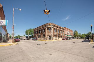
Akron is a town in Henry Township, Fulton County, Indiana, United States. The population was 1,167 at the 2010 census.

<span class="mw-page-title-main">Hanover, Maine</span> Town in the state of Maine, United States

Hanover is a town in Oxford County, Maine, United States. The population was 286 at the 2020 census. The town is a popular vacation and recreation area.

Bradley is a town in Penobscot County, Maine, United States. It is part of the Bangor Metropolitan Statistical Area. The population was 1,532 at the 2020 census. The village of Bradley is in the northwestern corner of the town.

<span class="mw-page-title-main">Ramsey, Minnesota</span> City in Minnesota, United States

Ramsey is a suburban city 22 miles (35 km) north-northwest of downtown Minneapolis in Anoka County, Minnesota, United States. The population was 27,646 at the 2020 census. It is a northwest suburb of the Twin Cities.

<span class="mw-page-title-main">Ashburn, Missouri</span> Town in Missouri, United States

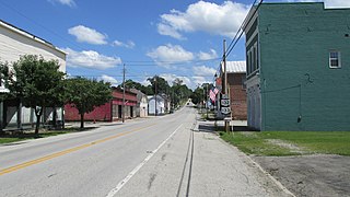
Ashburn is a town in Pike County, Missouri, United States. The population was 52 at the 2010 census.

<span class="mw-page-title-main">Mount Hope, New York</span> Town in New York, United States

Mount Hope is a town in the northwestern part of Orange County, New York, United States, west of Middletown. The northern town line is the border of Sullivan County. The population was 6,537 at the 2020 census.

<span class="mw-page-title-main">Morristown, Ohio</span> Village in Ohio, United States

Morristown is a village in Belmont County, Ohio, United States. The population was 248 at the 2020 census. It is part of the Wheeling metropolitan area.

<span class="mw-page-title-main">Clarksville, Ohio</span> Village in Ohio, United States

Clarksville is a village in Clinton County, Ohio, United States. The population was 534 at the 2020 census. It is served by the Clinton Massie branch of the Wilmington Public Library of Clinton County.

<span class="mw-page-title-main">Hartford, Ohio</span> Village in Ohio, United States

Hartford is a village in the township of the same name in Licking County, Ohio, United States. The population was 404 at the 2020 census.

<span class="mw-page-title-main">Chesterhill, Ohio</span> Village in Ohio, United States

Chesterhill is a village in Morgan County, Ohio, United States. The population was 276 at the 2020 census. Chesterhill was laid out in 1834, and named after Chester County, Pennsylvania, the native home of a large share of the first settlers.

<span class="mw-page-title-main">Rarden, Ohio</span> Village in Ohio, United States

Rarden is a village in Scioto County, Ohio, United States. The population was 146 at the 2020 census.

<span class="mw-page-title-main">Hartville, Ohio</span> Village in Ohio, United States

Hartville is a village in northern Stark County, Ohio, United States. The population was 3,329 at the 2020 census. It is part of the Canton–Massillon metropolitan area. Hartville lies halfway between Akron and Canton at the intersection of State Routes 43 and 619.

<span class="mw-page-title-main">Smithville, Ohio</span> Village in Ohio, United States

Smithville is a village in Wayne County, Ohio, United States. The population was 1,338 at the time of the 2020 census. The village derives its name from Thomas Smith, a pioneer settler.

<span class="mw-page-title-main">Oakvale, West Virginia</span> Town in West Virginia, United States

Oakvale is a town in Mercer County, West Virginia, United States, along the East River. The population was 137 at the 2020 census. It is part of the Bluefield, WV-VA micropolitan area which has a population of 107,578.

<span class="mw-page-title-main">Wild Rose, Wisconsin</span> Village in Wisconsin, United States

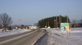
Wild Rose is a village in Waushara County, Wisconsin, United States. The population was 725 at the 2010 census.

Andover is a village located in the town of Andover in Allegany County, New York, United States. The population was 1,042 at the 2010 census. The name is derived from Andover, Vermont.

Sherman is a village in the town of Sherman, Chautauqua County, New York, United States. The village lies in the northern part of the town at intersections of County Routes 15 and 18, NY-76 and NY-430. The population was 681 at the 2020 census.

<span class="mw-page-title-main">Hustisford (town), Wisconsin</span> Town in Wisconsin, United States

Hustisford is a town in Dodge County, Wisconsin, United States. The population was 1,379 at the 2000 census. Most of the town residents live in the village of Hustisford, within the town.

References

  1. "ArcGIS REST Services Directory". United States Census Bureau. Retrieved September 20, 2022.
  2. 1 2 "U.S. Census website". United States Census Bureau . Retrieved January 31, 2008.
  3. "Galway Town History: The First Settlers". Town of Galway. Archived from the original on May 13, 2008. Retrieved June 6, 2009.
  4. "Census of Population and Housing". Census.gov. Retrieved June 4, 2015.