This article needs additional citations for verification .(March 2021) |
Saratoga | |
---|---|
Town of Saratoga | |
Coordinates: 43°4′N73°37′W / 43.067°N 73.617°W | |
Country | United States |
State | New York |
County | Saratoga |
Government | |
• Supervisor | Ian Murray |
Area | |
• Total | 42.90 sq mi (111.11 km2) |
• Land | 40.56 sq mi (105.05 km2) |
• Water | 2.34 sq mi (6.06 km2) |
Elevation | 440 ft (134 m) |
Population (2020) | |
• Total | 5,808 |
• Density | 140/sq mi (52/km2) |
Time zone | UTC-5 (Eastern (EST)) |
• Summer (DST) | UTC-4 (EDT) |
FIPS code | 36-65244 |
GNIS feature ID | 0979461 |
Website | www |
Saratoga is a town in Saratoga County, New York, United States. The population was 5,808 at the 2020 census. [2] [3] It is also the commonly used, but not official, name for the neighboring and much more populous city, Saratoga Springs. The major village in the town of Saratoga is Schuylerville, which is often, but not officially, called Old Saratoga. Saratoga contains a second village, named Victory.
Saratoga is a corruption of a Mohawk word. It was the name of Indian hunting grounds located along both sides of the Hudson River. According to the town's history, it derives from se-rach-ta-gue, meaning "the hillside country of the quiet river". [4]
Saratoga is located on the eastern border of the county and is located east of Saratoga Springs, and is bordered by Saratoga Lake and the Hudson River.
The town sends students to Saratoga Springs City School District, Schuylerville Central School District, and Stillwater Central School District.
The name may derive from the Iroquoian se-rach-ta-gue or sa-ra-ta-ke, which the early Dutch settlers rendered as "Sarachtoge". [5] A second early version of the name is, "Saraghtogo" [6] but the origin remains unproven and thus uncertain. [6]
The location was first settled at the end of the 17th century as "Fort Saratoga". Saratoga soon became contested land between British and French colonial forces, and the village of Saratoga (now Schuylerville) was destroyed by the French in 1745 during King George's War.
Saratoga was originally a district of Albany County stretching from north of the Mohawk River to Northumberland, including lands for six miles on both sides of the Hudson River. In 1775, the three districts were Ballstown, Halfmoon, and Saratoga.
It is best known as the location that British General John Burgoyne surrendered to American General Horatio Gates at the end of the Battles of Saratoga on October 17, 1777, often cited as the turning point for the United States during the American Revolution. The two battles took place in the town of Stillwater to the south, but the final 10 days of encampment and the actual surrender ceremony took place in Saratoga (Schuylerville).
In 1788, an act was passed organizing towns in place of districts and Stillwater was created from the Saratoga District, making four towns in what would become Saratoga County. These four mother towns were subdivided into the present 19 towns. The original town of Saratoga included the modern-day towns of Easton, Northumberland, Moreau, Wilton, portions of Greenfield and Corinth, and the city of Saratoga Springs. The first loss of territory was in 1789 to the town of Easton (now in Washington County). In 1798, the towns of Corinth, Greenfield, Northumberland, Moreau, and Wilton split from the town of Saratoga. In 1805, a narrow strip in the southwestern part of Saratoga was annexed to the town of Malta. In 1819, the town of Saratoga Springs was formed from the rest of the western part of the town of Saratoga. Later, this would become the city of Saratoga Springs. [7]
The Saratoga Race Course, in the adjoining city of Saratoga Springs, is the oldest operating horse-racing course in the US.
According to the United States Census Bureau, the town has a total area of 42.9 square miles (111 km2), of which 40.7 square miles (105 km2) are land and 2.2 square miles (5.7 km2) (5.22%) are water.
The town line is formed by the Hudson River and is the border of Washington County. Fish Creek, a tributary of the Hudson, is the outflow of Saratoga Lake.
U.S. Route 4 (Turning Point Trail [8] ) follows the Hudson River along the eastern part of the town. New York State Route 29 (General Philip Schuyler Commemorative Highway) is an east–west highway, intersecting US-4 at Schuylerville. New York State Route 32 is a north–south highway, partly conjoined with US-4 near Schuylerville.
Census | Pop. | Note | %± |
---|---|---|---|
1820 | 2,233 | — | |
1830 | 2,461 | 10.2% | |
1840 | 2,624 | 6.6% | |
1850 | 3,492 | 33.1% | |
1860 | 3,843 | 10.1% | |
1870 | 4,052 | 5.4% | |
1880 | 4,539 | 12.0% | |
1890 | 3,855 | −15.1% | |
1900 | 3,999 | 3.7% | |
1910 | 3,942 | −1.4% | |
1920 | 3,680 | −6.6% | |
1930 | 3,027 | −17.7% | |
1940 | 3,212 | 6.1% | |
1950 | 3,225 | 0.4% | |
1960 | 3,515 | 9.0% | |
1970 | 4,206 | 19.7% | |
1980 | 4,595 | 9.2% | |
1990 | 5,069 | 10.3% | |
2000 | 5,141 | 1.4% | |
2010 | 5,674 | 10.4% | |
2020 | 5,808 | 2.4% | |
U.S. Decennial Census [9] [10] |
As of the census [2] of 2000, 5,141 people, 2,026 households, and 1,387 families resided in the town. The population density was 126.4 inhabitants per square mile (48.8/km2). The 2,286 housing units averaged 56.2 per square mile (21.7/km2). The racial makeup of the town was 97.80% White, 0.97% African American, 0.06% Native American, 0.16% Asian, 0.06% Pacific Islander, 0.23% from other races, and 0.72% from two or more races. Hispanics or Latinos of any race were 1.17% of the population.
Of the 2,026 households, 31.5% had children under the age of 18 living with them, 54.9% were married couples living together, 9.4% had a female householder with no husband present, and 31.5% were not families. About 24.5% of all households were made up of individuals, and 9.7% had someone living alone who was 65 years of age or older. The average household size was 2.51 and the average family size was 3.00.
In the town, the population was distributed as 24.6% under the age of 18, 6.9% from 18 to 24, 29.9% from 25 to 44, 25.7% from 45 to 64, and 12.9% who were 65 years of age or older. The median age was 38 years. For every 100 females, there were 99.7 males. For every 100 females age 18 and over, there were 96.2 males.
The median income for a household in the town was $42,727, and for a family was $48,482. Males had a median income of $33,178 versus $27,654 for females. The per capita income for the town was $21,716. About 6.1% of families and 7.3% of the population were below the poverty line, including 6.8% of those under age 18 and 6.2% of those age 65 or over.
Hamden is a town in Delaware County, New York, United States. The population was 1,137 at the 2020 census.
Harpersfield is a town in Delaware County, New York, United States. The population was 1,442 at the 2020 census. The town is on the northern border of the county.
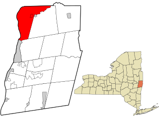
Roxbury is a town in Delaware County, New York, United States. The population was 2,247 at the 2020 census. The town is at the eastern end of the county.
Tompkins is a town in Delaware County, New York, United States. The population was 1,290 at the 2020 census. The town is named after Daniel D. Tompkins, the fourth governor of New York and sixth vice president of the United States.
Wilna is a town in Jefferson County, New York, United States. The population was 5,732 at the 2020 census. The town is on the eastern side of the county and is east of Watertown.
Moreau is a town in Saratoga County, New York, United States. The population was 16,202 at the 2020 census. The town is located in the northeast part of the county, north of Saratoga Springs. Moreau is named after Jean Victor Moreau, a French general, who visited the area just before the town was formed. The town contains a village called South Glens Falls.
Carlisle is a town in northern Schoharie County, New York, United States. The population was 1,768 at the 2020 census.
Seward is a town in Schoharie County, New York, United States. The population was 1,583 at the 2020 census. The town is named after senator, governor, and secretary of state William H. Seward.
Wright is a town in Schoharie County, New York, United States. The population was 1,516 at the 2020 census. The town was named after governor Silas Wright.
Johnsburg is a town in the northwestern corner of Warren County, New York, United States. It is part of the Glens Falls Metropolitan Statistical Area. The town population was 2,143 at the 2020 census. The town is named after John Thurman, an early settler and founder. Johnsburg is the largest town in Warren County by area.
Easton is a town in southwestern Washington County, New York, United States along the county's western boundary. It is part of the Glens Falls Metropolitan Statistical Area. The town population was 2,279 at the 2020 census. The town adopted English as its official language on July 6, 2010.
Hartford is a town centrally located in Washington County, New York, United States. It is part of the Glens Falls Metropolitan Statistical Area. The town population was 2,193 at the 2020 census.
Greenville is a hamlet and census-designated place (CDP) in the town of Greenville, in Greene County, New York, United States. The population of the CDP was 688 at the 2020 census, out of a total 3,741 people in the town as a whole.
SchaghticokeSKAT-i-kohk is a town in Rensselaer County, New York, United States. The population was 7,445 at the 2020 census. It was named for the Schaghticoke, a Native American tribe formed in the seventeenth century from an amalgamation of remnant peoples of eastern New York and New England. The tribe has one of the oldest reservations in the United States, located in what is now Litchfield County, Connecticut. It has been recognized by the state of Connecticut but has not yet achieved federal recognition.
Galway is a town located in Saratoga County, New York, United States. As of the 2020 census, the town had a total population of 3,525. The town contains a village also named Galway. Both the town and village are located in the western part of the county, north of Schenectady.
Milton is a town in Saratoga County, New York, United States. The population was 18,800 at the 2020 census. Some believe that the town was named after the poet, John Milton, while other sources state that it is a shortening of "Mill-town" for the early mill activity.
Stillwater is a town in Saratoga County, New York, United States, with a population of 8,287 at the 2010 census. The town contains a village called Stillwater. The town is at the eastern border of the county, southeast of Saratoga Springs and borders both Rensselaer and Washington counties. Saratoga National Historical Park is located within the town's limits. There is a hamlet in Minerva, Essex County, New York, with the same name which has nothing to do with this town.
Salem is a town in eastern Washington County, New York, United States. It is part of the Glens Falls Metropolitan Statistical Area. The town population was 2,612 at the 2020 census. The town of Salem contains a hamlet also named Salem, formerly an incorporated village.
Plattekill is a town in Ulster County, New York, United States. The population was 10,424 in 2020, a slight decrease from 10,499 at the 2010 census. The name is derived from a stream, the Platte Kill.
Greenwich is a town in the southwestern part of Washington County, New York, United States. The town is located on the western border of the county. The population was 4,868 at the 2020 census. It is part of the Glens Falls Metropolitan Statistical Area. Greenwich features several homes that were a part of the Underground Railroad.