Waterford (village), New York

Last updated

Waterford
Village of Waterford
Waterford NY village sign.jpg
Village of Waterford gateway sign
Village Waterford NY Locator Map.png
Map highlighting Waterford's location within Saratoga County.
USA New York location map.svg
Red pog.svg
Waterford
Location within the state of New York
Coordinates: 42°47′28″N73°40′47″W / 42.79111°N 73.67972°W / 42.79111; -73.67972
Country United States
State New York
County Saratoga
Incorporated1794
Area
[1]
  Total0.36 sq mi (0.93 km2)
  Land0.28 sq mi (0.73 km2)
  Water0.07 sq mi (0.19 km2)
Elevation
69 ft (21 m)
Population
 (2020)
  Total2,038
  Density7,201.41/sq mi (2,782.06/km2)
Time zone UTC-5 (Eastern (EST))
  Summer (DST) UTC-4 (EDT)
ZIP code
12188
Area code 518
FIPS code 36-78520 [2]
GNIS feature ID0968897 [3]
Website www.waterfordny.org
Waterford Harbor on the Mohawk River NYmohawk-WaterfordHarbor.JPG
Waterford Harbor on the Mohawk River

Waterford is a village in Saratoga County, New York, United States. The population was 2,038 at the 2020 census. The name derives from the ford between the mainland and Peebles Island.

Contents

The Village of Waterford is located in the southeastern part of the Town of Waterford, north-northwest of Troy, New York. The village is located just north of the falls where the eastbound Mohawk River empties into the southbound Hudson River.

History

The site of the village was occupied as "Half Moon Point" in the 17th century. It was then in the territory of Mahican natives. This early village was at the ford between Peebles Island and the mainland. The approximate location of this ford is in the area of the Second Street Bridge. Though the construction of the Erie Canal destroyed much of the ford for which the village is named, remnants of an unnamed and often submerged island can still be seen southwest of the entrance to the canal.[ citation needed ]

The village claims to be the oldest continuously incorporated village in the US. [4] It was the first village incorporated by the state legislature in 1794, while part of the Town of Halfmoon, and was an established political entity before the formation of the Town of Waterford.[ citation needed ] Waterford Village is one of only twelve villages in New York still incorporated under a charter, the other villages having incorporated or re-incorporated under the provisions of Village Law. [5]

Geography

The Village of Waterford is located at 42°47′28″N73°40′47″W / 42.79111°N 73.67972°W / 42.79111; -73.67972 (42.791127, -73.679758). [6]

According to the United States Census Bureau, the village has a total area of 0.4 square mile (0.9 km2), of which 0.3 square mile (0.8 km2) is land and 0.1 square mile (0.2 km2) (22.22%) is water.

Waterford is on the west bank of the Hudson River and north of Peebles Island State Park. The village was at the northern extreme of navigation on the Hudson River, and later became the eastern terminus of the Erie Canal and the southern terminus of the Champlain Canal. Although the north–south right-of-way of the Champlain Canal through Waterford has largely been abandoned and bypassed, the east-west Erie Canal continues to operate under the administration of the New York State Canal System (formerly called the New York State Barge Canal).

The historic Waterford Flight , comprising locks 2, 3, 4, 5, and 6 of the Erie Canal is located here, along with defunct former locks of the Champlain Canal. The Waterford Flight locks were opened circa 1918 to replace earlier locks that had first allowed boat traffic to bypass nearby Cohoes Falls, which had previously blocked all river traffic between the Mohawk and the Hudson Rivers. The Waterford Flight series of locks is one of the steepest in the world. [7] [8]

While much of the surrounding town has a high elevation, the Village of Waterford is very low relative to the two major rivers forming its borders. Its position at the convergence of both the Erie and Champlain Canals as well as the Mohawk and Hudson Rivers, has contributed to many floods. While major floods have been rare through the last half of the 20th century to the present, the most recent flood of significance was in late June and early July 2006. The flood forced the closing of the Erie Canal, stranding several boats in the locks.[ citation needed ]

Entering from the north, conjoined U.S. Route 4 and New York State Route 32 diverge in Waterford Village, with US-4 (as Broad Street) crossing the Hudson River eastbound into Rensselaer County and NY-32 crossing the Mohawk River southbound into Albany County. County Roads 96 (6th Street) and 97 (Washington Avenue) lead into the village from the northwest.

Demographics

Historical population
CensusPop.Note
1870 3,071
1880 1,822−40.7%
1900 3,146
1910 3,2453.1%
1920 2,637−18.7%
1930 2,92110.8%
1940 2,903−0.6%
1950 2,9682.2%
1960 2,915−1.8%
1970 2,879−1.2%
1980 2,405−16.5%
1990 2,370−1.5%
2000 2,204−7.0%
2010 1,990−9.7%
2020 2,0382.4%
U.S. Decennial Census [9]

As of the census [2] of 2000, there were 2,204 people, 951 households, and 543 families residing in the village. The population density was 7,731.2 inhabitants per square mile (2,985.0/km2). There were 1,062 housing units at an average density of 3,725.3 per square mile (1,438.3/km2). The racial makeup of the village was 96.05% White, 0.77% Black or African American, 0.18% Native American, 1.50% Asian, 0.09% from other races, and 1.41% from two or more races. Hispanic or Latino of any race were 0.45% of the population.

There were 951 households, out of which 28.8% had children under the age of 18 living with them, 39.3% were married couples living together, 14.0% had a female householder with no husband present, and 42.8% were non-families. 34.8% of all households were made up of individuals, and 13.6% had someone living alone who was 65 years of age or older. The average household size was 2.30 and the average family size was 3.06.

In the village, the population was spread out, with 23.9% under the age of 18, 10.0% from 18 to 24, 31.6% from 25 to 44, 19.7% from 45 to 64, and 14.8% who were 65 years of age or older. The median age was 36 years. For every 100 females, there were 90.8 males. For every 100 females age 18 and over, there were 86.2 males.

The median income for a household in the village was $34,135, and the median income for a family was $45,375. Males had a median income of $35,543 versus $25,912 for females. The per capita income for the village was $18,141. About 11.4% of families and 12.6% of the population were below the poverty line, including 22.3% of those under age 18 and 6.1% of those age 65 or over.

See also

Related Research Articles

<span class="mw-page-title-main">Erie Canal</span> Waterway in New York, U.S.

The Erie Canal is a historic canal in upstate New York that runs east–west between the Hudson River and Lake Erie. Completed in 1825, the canal was the first navigable waterway connecting the Atlantic Ocean to the Great Lakes, vastly reducing the costs of transporting people and goods across the Appalachians. In effect, the canal accelerated the settlement of the Great Lakes region, the westward expansion of the United States, and the economic ascendancy of New York State. It has been called "The Nation's First Superhighway."

<span class="mw-page-title-main">Cohoes, New York</span> City in New York, United States

Cohoes is an incorporated city located in the northeast corner of Albany County in the U.S. state of New York. It is called the "Spindle City" because of the importance of textile manufacturing to its growth in the 19th century. The city's factories processed cotton from the Deep South.

<span class="mw-page-title-main">Montezuma, New York</span> Town in New York, United States

Montezuma is a town in Cayuga County, New York, United States. The population was 1,277 at the 2010 census.

Mohawk is a village in Herkimer County, New York, United States. The population was 2,731 at the 2010 census. The village was named after the adjacent Mohawk River.

<span class="mw-page-title-main">Florida, Montgomery County, New York</span> Town in New York, United States

Florida is a town south of the Mohawk River in Montgomery County, New York, United States. The population was 2,696 in the 2010 United States Census. The town was named after the state of Florida. It is located in the eastern end of Montgomery County and is south of the City of Amsterdam, which it borders.

<span class="mw-page-title-main">Fonda, New York</span> Village in New York, United States

Fonda is a village in and the county seat of Montgomery County, New York, United States. The population was 668 at the 2020 census. The village is named after Douw Fonda, a Dutch-American settler who was killed and scalped in 1780, during a Mohawk raid in the Revolutionary War, when the tribe was allied with the British.

Fort Plain is a village in Montgomery County, New York, United States. As of the 2010 census, the village population was 2,322. The village is named after a fort built during the American Revolution at the junction of the Mohawk River and its tributary Otsquago Creek.

<span class="mw-page-title-main">Halfmoon, New York</span> Town in New York, United States

Halfmoon is a town in Saratoga County, New York, United States. The population was 25,662 at the 2020 census. The town is apparently named for the shape of the lower elevation land north of the junction of the Hudson and Mohawk Rivers. It is also said to be named for Henry Hudson's ship, the Halve Maen.

<span class="mw-page-title-main">Green Island, New York</span> Town and village in New York, United States

Green Island is a coterminous town-village in Albany County, New York, United States, some 8 miles (13 km) north of Albany. Green Island is one of only five such town-village amalgamations in New York. The population was 2,934 at the 2020 census, and the ZIP code is 12183. While the town of Green Island was once an island, it was connected to the mainland on the west side of the Hudson River in the 1960s.

<span class="mw-page-title-main">Herkimer (village), New York</span> Village in Herkimer County, New York, US

Herkimer is a village on the north side of the Mohawk River and the county seat of Herkimer County, New York, United States, about 15 miles (24 km) southeast of Utica. As of the 2020 Census, it had a population of 7,234, and a predicted population of 7,283 on July 1, 2022. It was part of the Burnetsfield Patent and the first colonial settlement this far west in the Mohawk Valley.

<span class="mw-page-title-main">Little Falls, New York</span> City in Herkimer County, New York

Little Falls is a city in Herkimer County, New York, United States. The population was 4,946 at the time of the 2010 census, which is the second-smallest city population in the state, ahead of only the city of Sherrill. The city is built on both sides of the Mohawk River, at a point at which rapids had impeded travel upriver. Transportation through the valley was improved by construction of the Erie Canal, completed in 1825 and connecting the Great Lakes with the Hudson River.

<span class="mw-page-title-main">Canajoharie (village), New York</span> Village in New York, United States

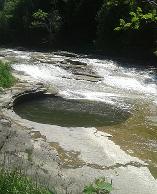
Canajoharie is a village in the Town of Canajoharie in Montgomery County, New York, United States. As of the 2010 census, the village had a population of 2,229. The name is said to be a Mohawk language term meaning "the pot that washes itself," referring to the "Canajoharie Boiling Pot," a circular gorge in the Canajoharie Creek, just south of the village.

<span class="mw-page-title-main">Canajoharie, New York</span> Town in New York, United States

Canajoharie is a town in Montgomery County, New York, United States. The population was 3,730 in 2010. Canajoharie is located south of the Mohawk River on the southern border of the county. The Erie Canal passes along the northern town line. There is also a village of Canajoharie in the town. Both are east of Utica and west of Amsterdam.

<span class="mw-page-title-main">Waterford, New York</span> Town in New York, United States

Waterford is a town in Saratoga County, New York, United States. The population was 8,208 at the 2020 census. The name of the town is derived from its principal village, also called Waterford. The town is located in the southeast corner of Saratoga County and north-northwest of Troy at the junction of the Erie Canal and the Hudson River.

<span class="mw-page-title-main">New York State Canal System</span> Canal system in New York

The New York State Canal System is a successor to the Erie Canal and other canals within New York. The 525-mile (845 km) system is composed of the Erie Canal, the Oswego Canal, the Cayuga–Seneca Canal, and the Champlain Canal. In 2014 the entire system was listed as a national historic district on the National Register of Historic Places, and in 2016 it was designated a National Historic Landmark.

<span class="mw-page-title-main">Champlain Canal</span> Canal in New York State, US

The Champlain Canal is a 60-mile (97 km) canal in New York that connects the Hudson River to the south end of Lake Champlain. It was simultaneously constructed with the Erie Canal for use by commercial vessels, fully opening in 1823. Today, it is mostly used by recreational boaters as part of the New York State Canal System and Lakes to Locks Passage.

<span class="mw-page-title-main">Mohawk Towpath Scenic Byway</span>

The Mohawk Towpath Scenic Byway is a National Scenic Byway in the Capital District region of New York in the United States. It extends from Schenectady to Waterford by way of a series of local, county, and state highways along the Mohawk River and the Erie Canal. The byway is intended to showcase the history of the waterway, from Native American times through the creation of the Erie Canal and the role the waterside communities played in the Industrial Revolution and the westward expansion of the United States. At its east end, the byway connects to the Lakes to Locks Passage, an All-American Road.

<span class="mw-page-title-main">Fort Edward (village), New York</span> Village in New York, United States

Fort Edward is a village in Washington County, New York, United States. It is part of the Glens Falls Metropolitan Statistical Area. The village population was 3,375 at the 2010 census. The name is derived from the younger brother of King George III, Edward Augustus, Duke of York and Albany.

<span class="mw-page-title-main">Sprouts of the Mohawk River</span>

The Sprouts of the Mohawk River are the multiple channels of the Mohawk River as it flows into the Hudson River creating a delta in the US state of New York. Most of the sprouts lie within Albany County, with the northern ones in Saratoga County, and the sprouts enter the Hudson at the boundary with Rensselaer County. The islands formed by the sprouts are, from north to south–Peebles Island, Polrump Island, Bock Island, Goat Island, Second Island, Van Schaick Island, Simmons Island. and formerly Green Island. The sprout separating Green Island from the rest of Albany County was filled in with the creation of Interstate 787 and NY Route 787.

<span class="mw-page-title-main">Waterford Flight</span>

The Waterford Flight is a set of locks on the Erie Canal in upstate New York. Erie Canal Locks E-2 through E-6 make up the combined flight at Waterford, which lifts vessels from the Hudson River to the Mohawk River, bypassing Cohoes Falls. Built in 1915, the Waterford Flight is still in use today as part of the New York State Canal System, which is open to public and commercial traffic. The Waterford Flight is the series of locks with the highest elevation gain relative to its length for any canal lock system in the United States.

References

  1. "ArcGIS REST Services Directory". United States Census Bureau. Retrieved September 20, 2022.
  2. 1 2 "U.S. Census website". United States Census Bureau . Retrieved January 31, 2008.
  3. "US Board on Geographic Names". United States Geological Survey. October 25, 2007. Retrieved January 31, 2008.
  4. State Historic Marker (Flickr photo by Dan Yetto)
  5. "Local Government Handbook - Village Government: Historical Development" (PDF) (5th ed.). New York State Department of State. 2008. pp. PDF page 72. Retrieved June 26, 2009.
  6. "US Gazetteer files: 2010, 2000, and 1990". United States Census Bureau. February 12, 2011. Retrieved April 23, 2011.
  7. Finch, Roy G. (1988) [1925]. The Story of the New York State Canals: Historical and Commercial Information (PDF). New York State Canal Corporation. p. 19. Retrieved March 9, 2013.
  8. "Dedication of the Flight of Five Locks as a Civil Engineering Landmark (9/9/2012)". ASCE Rennselaer. American Society of Civil Engineers (ASCE), RPI Chapter. Retrieved March 2, 2013.
  9. "Census of Population and Housing". Census.gov. Retrieved June 4, 2015.