Cobleskill (village), New York

Last updated

Cobleskill, New York
USA New York location map.svg
Red pog.svg
Cobleskill, New York
Location within the state of New York
Coordinates: 42°40′45″N74°29′8″W / 42.67917°N 74.48556°W / 42.67917; -74.48556
Country United States
State New York
County Schoharie County, New York
Incorporated1868 [1]
Government
  TypeMayor/Board of Trustees
   Mayor Rebecca Stanton-Terk
Area
[2]
  Total3.57 sq mi (9.24 km2)
  Land3.56 sq mi (9.23 km2)
  Water0.00 sq mi (0.01 km2)
Elevation
922 ft (281 m)
Population
 (2020)
  Total4,173
  Density1,170.55/sq mi (451.98/km2)
Time zone UTC-5 (Eastern (EST))
  Summer (DST) UTC-4 (EDT)
ZIP code
12043
Area code 518
FIPS code 36-16628
GNIS feature ID0946981
Website Village of Cobleskill, NY

Cobleskill is a village in the western part of the town of Cobleskill in Schoharie County, New York, United States. The population was 4,678 at the 2010 census. [3]

Contents

The village is southwest of Amsterdam. The State University of New York at Cobleskill is located at the western side of the village.

History

The village was settled in 1752, [4] and was incorporated in 1868. [5]

It is generally accepted that a German grist miller named Jacob Kobel (variated as Kobus, or Coble) built a mill on the Cobleskill Creek. The Dutch word for river or creek is kill , thus the name Cobleskill, for "Cobel's creek". [6]

The Schoharie County Sunshine Fair, formerly known as the Cobleskill Sunshine Fair, has been held annually in Cobleskill since 1876. [7] An agricultural fair, it draws tens of thousands of people [8] to attractions such as livestock shows, demolition derbies and tractor pulls. [9] [10]

The Cobleskill Historic District was listed on the National Register of Historic Places in 1978. [11]

Geography

According to the United States Census Bureau, the village has a total area of 3.3 square miles (8.5 km2), all land.

A USGS Benchmark on the side of southeastern corner of the William H. Golding 6-8 Middle School is marked at 1028 feet above sea level. The valley Cobleskill is situated in, is on the boundary of the geologic regions of New York known as the Catskill plateau to the south, and the Escarpment region of the Mohawk Valley to the North.

Cobleskill is north of the Cobleskill Creek.

New York State Route 10 and New York State Route 7 intersect New York State Route 145 in the village. Interstate 88 passes south of the village.

Demographics

Historical population
CensusPop.Note
1870 1,030
1880 1,23219.6%
1890 1,82247.9%
1900 2,32727.7%
1910 2,088−10.3%
1920 2,41015.4%
1930 2,5947.6%
1940 2,6170.9%
1950 3,20822.6%
1960 3,4718.2%
1970 4,36825.8%
1980 5,27220.7%
1990 5,268−0.1%
2000 4,533−14.0%
2010 4,6783.2%
2020 4,173−10.8%
U.S. Decennial Census [12]

As of the census of 2000, there were 4,533 people, 1,537 households, and 794 families residing in the village. The population density was 1,386.3 inhabitants per square mile (535.3/km2). There were 1,706 housing units at an average density of 521.7 per square mile (201.4/km2). The racial makeup of the village was 90.75% White, 4.23% Black or African American, 0.24% Native American, 1.39% Asian, 0.07% Pacific Islander, 0.66% from other races, and 1.35% from two or more races. Hispanic or Latino of any race were 3.03% of the population. [3]

There were 1,537 households, out of which 23.6% had children under the age of 18 living with them, 35.7% were married couples living together, 10.0% had a female householder with no husband present, and 50.9% were non-families. 41.8% of all households were made up of individuals, and 20.6% had someone living alone who was 65 years of age or older. The average household size was 2.07 and the average family size was 2.85. [3]

In the village, the population was spread out, with 15.8% under the age of 18, 32.6% from 18 to 24, 18.1% from 25 to 44, 16.4% from 45 to 64, and 17.2% who were 65 years of age or older. The median age was 27 years. For every 100 females, there were 91.3 males. For every 100 females age 18 and over, there were 89.8 males. [3]

The median income for a household in the village was $28,011, and the median income for a family was $43,714. Males had a median income of $29,375 versus $29,712 for females. The per capita income for the village was $15,213. About 11.3% of families and 19.8% of the population were below the poverty line, including 17.8% of those under age 18 and 10.6% of those age 65 or over. [3]

Related Research Articles

<span class="mw-page-title-main">Schoharie County, New York</span> County in New York, United States

Schoharie County is a county in the U.S. state of New York. As of the 2020 census, the population was 29,714, making it the state's fifth-least populous county. The county seat is Schoharie. "Schoharie" comes from a Mohawk word meaning "floating driftwood." Schoharie County is part of the Albany-Schenectady-Troy, NY Metropolitan Statistical Area.

<span class="mw-page-title-main">Lexington, New York</span> Town in New York, United States

Lexington is a town in Greene County, New York, United States. The population was 770 at the 2020 census. The town is in the southwestern part of Greene County.

<span class="mw-page-title-main">Charleston, New York</span> Town in Montgomery County, NY

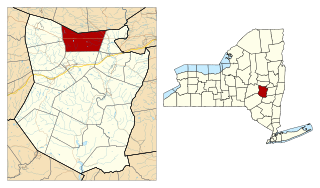
Charleston is a town in Montgomery County, New York, United States. The population was 1,373 at the 2010 census. The town was named for Charles Van Epps, an early settler.

<span class="mw-page-title-main">Florida, Montgomery County, New York</span> Town in New York, United States

Florida is a town south of the Mohawk River in Montgomery County, New York, United States. The population was 2,696 in the 2010 United States Census. The town was named after the state of Florida. It is located in the eastern end of Montgomery County and is south of the City of Amsterdam, which it borders.

<span class="mw-page-title-main">Carlisle, New York</span> Town in New York, United States

Carlisle is a town in northern Schoharie County, New York, United States. The population was 1,758 at the 2000 census.

<span class="mw-page-title-main">Conesville, New York</span> Town in New York, United States

Conesville is a town in Schoharie County, New York, United States. The population was 687 at the 2020 census. The town is named after Jonathan Cone, an early resident.

<span class="mw-page-title-main">Gilboa, New York</span> Town in New York, United States

Gilboa is a town in Schoharie County, New York, United States. The population was 1,111 at the 2020 census.

<span class="mw-page-title-main">Summit, New York</span> Town in New York, United States

Summit is a town in Schoharie County, New York, United States. The population was 1,123 at the time of the 2000 census. The name is derived from a peak that was thought to be the highest elevation in the county.

<span class="mw-page-title-main">Livingston Manor, New York</span> CDP and hamlet in New York, United States

Livingston Manor is a hamlet in Sullivan County, New York, United States. The population was 1,221 at the 2010 census.

<span class="mw-page-title-main">Marcellus (village), New York</span> Village in New York, United States

Marcellus is a village in the town of Marcellus in Onondaga County, New York, United States. As of the 2020 census, the population was 1,745. The village is southwest of Syracuse and is in the southern part of the town of Marcellus.

<span class="mw-page-title-main">Esperance (town), New York</span> Town in New York, United States

Esperance is a town in Schoharie County, New York, United States. The population was 2,043 at the 2000 census. The town was given the name of the principal village, which was named for "hope" in French.

Middleburgh is a village in Schoharie County, New York, United States. The population was 1,500 at the 2010 census. The Village of Middleburgh is in the southwestern part of the Town of Middleburgh and is west of Albany.

<span class="mw-page-title-main">Middleburgh, New York</span> Town in New York, United States

Middleburgh is a town in Schoharie County, New York, United States. The population was 3,515 at the 2000 census.

<span class="mw-page-title-main">Richmondville, New York</span> Town in New York, United States

Richmondville is a town in Schoharie County, New York, United States. The population was 2,610 at the 2010 census. The town name was adapted from the name of a post office in its territory.

<span class="mw-page-title-main">Schoharie (village), New York</span> Village in New York, United States

Schoharie is a village in Schoharie County, New York, United States. The population was 922 at the 2010 census. It is the county seat of Schoharie County. The name is a native word for driftwood.

<span class="mw-page-title-main">Schoharie, New York</span> Town in New York, United States

Schoharie is an incorporated town in and the county seat of Schoharie County, New York. The population was 3,299 at the 2000 census.

<span class="mw-page-title-main">Charles Goodyear (politician)</span> American attorney and politician

Charles Goodyear was a banker, attorney, and politician from New York. He was most notable for his service as a United States representative from 1845 to 1847 and 1865 to 1867.

John Gebhard was an American lawyer and politician from New York.

Henry Hamilton was an American lawyer and politician from New York.

<span class="mw-page-title-main">Cobleskill (town), New York</span> Town in New York, United States

Cobleskill is a town in Schoharie County, New York, United States. The population was 6,086 at the 2020 census. The town contains a village, also named Cobleskill, as well as the State University of New York at Cobleskill.

References

  1. Roscoe, William E. (1882). "Chapter XXIII". History of Schoharie County, New York, 1713-1882. Truair, Smith & Bruce Printers and Binders. Syracuse, New York: D. Mason & Co. ISBN   978-0-7884-0060-5 . Retrieved April 23, 2009. The village of Cobleskill was incorporated by Legislative act passed April 3, 1868, …
  2. "ArcGIS REST Services Directory". United States Census Bureau. Retrieved September 20, 2022.
  3. 1 2 3 4 5 "U.S. Census website". United States Census Bureau . Retrieved January 31, 2008.
  4. Roscoe, William E. (1882). "Chapter II". History of Schoharie County, New York, 1713-1882. Truair, Smith & Bruce Printers and Binders. Syracuse, New York: D. Mason & Co. ISBN   978-0-7884-0060-5 . Retrieved April 23, 2009. … the valley of the Cobleskill and its branch the Westkill, was first settled in 1752 and 1754.
  5. Roscoe, William E. (1882). "Chapter XXIII". History of Schoharie County, New York, 1713-1882. Truair, Smith & Bruce Printers and Binders. Syracuse, New York: D. Mason & Co. ISBN   978-0-7884-0060-5 . Retrieved April 23, 2009. The village of Cobleskill was incorporated by Legislative act passed April 3, 1868, …
  6. Simms, Jeptha Root (1845). "Chapter III". History of Schoharie County, and Border Wars of New York. Albany, New York: Munsell & Tanner, Printers. ISBN   978-1-55613-393-0 . Retrieved April 23, 2009. This creek took its name after the paternal name of the mill-wright, as Judge Brown assured me. I find the name written Cobels kill in many of the old conveyances, and in all the early Sessions laws, of the state. It is, in truth, the correct orthography of the word.
  7. Simonson, Mark (August 2, 2008). "Sunshine Fair growth dramatic over 122 years". The Daily Star. Retrieved July 21, 2010.
  8. "2003 Fair Results". AllBusiness.com. Amusement Business. September 1, 2003. Retrieved July 21, 2010.
  9. "2010 Grandstand Schedule of Events". Cobleskill Agricultural Society. Retrieved July 21, 2010.
  10. "On the Grounds Every Day". Cobleskill Agricultural Society. Retrieved July 21, 2010.
  11. "National Register Information System". National Register of Historic Places . National Park Service. March 13, 2009.
  12. "Census of Population and Housing". Census.gov. Retrieved June 4, 2015.