Richmondville, New York

Last updated

Richmondville, New York
Schoharie County NY Richmondville town highlighted.svg
Location in Schoharie County and the state of New York.
Coordinates: 42°38′2″N74°34′0″W / 42.63389°N 74.56667°W / 42.63389; -74.56667
Country United States
State New York
County Schoharie
Government
  Type Town Council
   Town Supervisor Jeffrey Haslun (R)
   Town Council
Members' List
Area
[1]
  Total30.23 sq mi (78.28 km2)
  Land30.16 sq mi (78.11 km2)
  Water0.07 sq mi (0.17 km2)
Population
 (2020)
  Total2,466
  Density82.26/sq mi (31.76/km2)
Time zone UTC-5 (Eastern (EST))
  Summer (DST) UTC-4 (EDT)
FIPS code 36-095-61599
Website Town website

Richmondville is a town in Schoharie County, New York, United States. The population was 2,466 at the 2020 census. [2] The town name was adapted from the name of a post office in its territory.

Contents

The Town of Richmondville has within itself a village called Richmondville. The town is at the western border of the county and is northeast of Oneonta.

History

The town was first settled circa 1764, near the community of Warnerville.

The "Battle of Cobleskill", fought during the American Revolution, actually took place in Richmondville.

The town was formed from part of the territory of Cobleskill in 1849. In 1851, the town added territory from the town of Seward.

In 1881, the community of Richmondville set itself off from the town by incorporating as a village.

Richmondville was, for many years, the location of the Central School for surrounding communities. The school, built in 1932, was originally called Richmondville Central School, educating children from K-12. The school now serves as an elementary school and was renamed the JOSEPH B.RADEZ Elementary School after its long-time school principal. The school is part of the Cobleskill-Richmondville Central School District.

Geography

According to the United States Census Bureau, the town has a total area of 30.2 square miles (78.3 km2), of which 30.2 square miles (78.2 km2) is land and 0.04 square mile (0.1 km2) (0.10%) is water. Elevations within Richmondville range from 920 feet along the Cobleskill-Richmondville boundary at Cobleskill Creek to 2,160 feet near the junction of Cross Hill Road and Dodge Lodge Road in the southeastern corner of the town.

Interstate 88 passes across the town. Before the construction of I-88, New York State Route 10 was a north-south highway into the village of Richmondville. Now NYS Rt 10 bypasses the village to the east and intersects NYS RT 7 at an interchange with I-88. New York State Route 7 runs concurrently with NY-10 through part of Richmondville.

The western town line is the border of Otsego County.

Demographics

Historical population
CensusPop.Note
1850 1,666
1860 2,02321.4%
1870 2,30714.0%
1880 2,082−9.8%
1890 1,917−7.9%
1900 1,719−10.3%
1910 1,430−16.8%
1920 1,378−3.6%
1930 1,4636.2%
1940 1,5032.7%
1950 1,72815.0%
1960 1,7461.0%
1970 1,9039.0%
1980 2,18614.9%
1990 2,3979.7%
2000 2,4120.6%
2010 2,6108.2%
2020 2,466−5.5%
U.S. Decennial Census [3]

As of the census [4] of 2000, there were 2,412 people, 968 households, and 686 families residing in the town. The population density was 79.9 inhabitants per square mile (30.8/km2). There were 1,141 housing units at an average density of 37.8 per square mile (14.6/km2). The racial makeup of the town was 96.81% White, 0.70% Black or African American, 0.50% Native American, 0.50% Asian, 0.83% from other races, and 0.66% from two or more races. Hispanic or Latino of any race were 1.58% of the population.

There were 968 households, out of which 32.3% had children under the age of 18 living with them, 54.8% were married couples living together, 11.7% had a female householder with no husband present, and 29.1% were non-families. 23.6% of all households were made up of individuals, and 9.3% had someone living alone who was 65 years of age or older. The average household size was 2.49 and the average family size was 2.93.

In the town, the population was spread out, with 26.0% under the age of 18, 7.0% from 18 to 24, 29.0% from 25 to 44, 22.8% from 45 to 64, and 15.2% who were 65 years of age or older. The median age was 37 years. For every 100 females, there were 103.0 males. For every 100 females age 18 and over, there were 94.9 males.

The median income for a household in the town was $34,761, and the median income for a family was $38,466. Males had a median income of $30,466 versus $22,738 for females. The per capita income for the town was $17,188. About 5.5% of families and 8.2% of the population were below the poverty line, including 8.6% of those under age 18 and 3.7% of those age 65 or over.

Communities and locations in the Town of Richmondville

Related Research Articles

<span class="mw-page-title-main">Schoharie County, New York</span> County in New York, United States

Schoharie County is a county in the U.S. state of New York. As of the 2020 census, the population was 29,714, making it the state's fifth-least populous county. The county seat is Schoharie. "Schoharie" comes from a Mohawk word meaning "floating driftwood." Schoharie County is part of the Albany-Schenectady-Troy, NY Metropolitan Statistical Area. The county is part of the Mohawk Valley region of the state.

<span class="mw-page-title-main">Chenango, New York</span> Town in New York, United States

Chenango is a town in Broome County, New York, United States. The population was 10,983 at the 2020 census.

Hamden is a town in Delaware County, New York, United States. The population was 1,137 at the 2020 census.

<span class="mw-page-title-main">Collins, New York</span> Town in New York, United States

Collins is a town in Erie County, New York, United States. The town is on the south border of the county and is considered to be one of the "Southtowns" of Erie County. The population at the 2010 census was 6,601.

<span class="mw-page-title-main">LaFayette, New York</span> Town in Onondaga County, New York, U.S.

LaFayette is a town in Onondaga County, New York, United States. As of the 2020 Census, its population was 4,910. The town is named after the Marquis de Lafayette, a key figure in the French and American revolutions, and widely considered a national hero of France and the United States. LaFayette is in the southern part of Onondaga County, south of Syracuse.

South Bristol is a town in Ontario County, New York, United States. The population was 1,651 at the 2020 census. The name is derived from its separation from the Town of Bristol.

<span class="mw-page-title-main">Maryland, New York</span> Town in New York, United States

Maryland is a town in Otsego County, New York, United States. The population was 1,897 at the 2010 census. It was named for the U.S. state of the same name. The Town of Maryland is on the county's southern border. It is northeast of the City of Oneonta.

<span class="mw-page-title-main">Moreau, New York</span> Town in New York, United States

Moreau is a town in Saratoga County, New York, United States. The population was 16,202 at the 2020 census. The town is located in the northeast part of the county, north of Saratoga Springs. Moreau is named after Jean Victor Moreau, a French general, who visited the area just before the town was formed. The town contains a village called South Glens Falls.

<span class="mw-page-title-main">Summit, New York</span> Town in New York, United States

Summit is a town in Schoharie County, New York, United States. The population was 1,072 at the time of the 2020 census. The name is derived from a peak that was thought to be the highest elevation in the county.

<span class="mw-page-title-main">Howard, New York</span> Town in New York, United States

Howard is a town in Steuben County, New York, United States. The population was 1,380 at the 2020 census.

Richford is a town in Tioga County, New York, United States. The population was 1,043 at the 2020 census. The town is named after Ezekial Rich, an early settler and benefactor of the town.

<span class="mw-page-title-main">Almond, New York</span> Town in New York, United States

Almond is a town in Allegany County, New York, United States. The population was 1,526 at the 2020 census.

Allegany is a town in Cattaraugus County, New York, United States. The population was 7,493 at the 2020 census.

<span class="mw-page-title-main">Afton, New York</span> Town in New York, United States

Afton is a town in Chenango County, New York, United States. The population was 2,769 at the 2020 census. Afton is situated in the southeast corner of the county and lies wholly within the original Township of Clinton. It was formed from the town of Bainbridge on November 18, 1857, and derives its name from Afton Water, a small river in the parish of New Cumnock, Ayrshire, Scotland, immortalized by the poet Robert Burns. It is bounded on the north by Bainbridge and Coventry, on the east by Delaware County, and on the west and south by Broome County.

<span class="mw-page-title-main">Camillus, New York</span> Town in New York, United States

Camillus is a town in Onondaga County, New York, United States. As of the 2020 Census, the population was 25,346.

Cobleskill is a village in the western part of the town of Cobleskill in Schoharie County, New York, United States. The population was 4,678 at the 2010 census.

<span class="mw-page-title-main">Middleburgh, New York</span> Town in New York, United States

Middleburgh is a town in Schoharie County, New York, United States. The population was 3,112 at the 2000 census.

Richmondville is a village in Schoharie County, New York, United States. The population was 918 at the 2010 census.

<span class="mw-page-title-main">Waterloo, New York</span> Town in New York, United States

Waterloo is a town in Seneca County, New York, United States. The population was 7,378 at the 2020 census. The town and its major community are named after Waterloo, Belgium, where Napoleon was defeated.

<span class="mw-page-title-main">Cobleskill, New York</span> Town in New York, United States

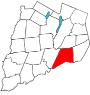
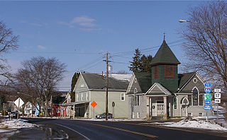
Cobleskill is a town in Schoharie County, New York, United States. The population was 6,086 at the 2020 census. The town contains a village, also named Cobleskill, as well as the State University of New York at Cobleskill.

References

  1. "2016 U.S. Gazetteer Files". United States Census Bureau. Retrieved July 5, 2017.
  2. "2020 Census Data". United States Census Bureau. Retrieved October 2, 2023.
  3. "Census of Population and Housing". United States Census Bureau. Retrieved June 4, 2015.
  4. "U.S. Census website". United States Census Bureau . Retrieved January 31, 2008.
  5. "National Register of Historic Places". Weekly List of Actions Taken on Properties: 2/04/13 through 2/08/13. National Park Service. February 15, 2013.