Richmondville (village), New York

Last updated
Richmondville, New York
USA New York location map.svg
Red pog.svg
Richmondville, New York
Location within the state of New York
Coordinates: 42°38′2″N74°34′0″W / 42.63389°N 74.56667°W / 42.63389; -74.56667 Coordinates: 42°38′2″N74°34′0″W / 42.63389°N 74.56667°W / 42.63389; -74.56667
Country United States
State New York
County Schoharie
Town Richmondville
Government
  TypeMayor/Board of Trustees
  MayorKevin Neary (D)
Area
[1]
  Total1.85 sq mi (4.78 km2)
  Land1.85 sq mi (4.78 km2)
  Water0.00 sq mi (0.00 km2)
Elevation
1,096 ft (334 m)
Population
 (2020)
  Total858
  Density464.79/sq mi (179.42/km2)
Time zone UTC-5 (Eastern (EST))
  Summer (DST) UTC-4 (EDT)
ZIP code
12149
Area code 518
FIPS code 36-61588
GNIS feature ID2391095
Website www.schohariecounty-ny.gov/CountyWebSite/villric/index.jsp

Richmondville is a village in Schoharie County, New York, United States. The population was 918 at the 2010 census.

Contents

The Village of Richmondville is in the center of the Town of Richmondville and is northeast of Oneonta.

History

The early village was the location of many mills and small factories. The village was incorporated in 1881.

The Bunn–Tillapaugh Feed Mill and Richmondville United Methodist Church are listed on the National Register of Historic Places. [2]

Geography

Richmondville is located at 42°38′1″N74°33′59″W / 42.63361°N 74.56639°W / 42.63361; -74.56639 (42.633838, -74.566627). [3]

According to the United States Census Bureau, the village has a total area of 1.8 square miles (4.7 km2), all land.

Interstate 88 passes through the village. State routes 7 (Main Street) and 10, along with County Road 22, intersect in the village.

Demographics

Historical population
CensusPop.Note
1870 630
1880 6533.7%
1890 6631.5%
1900 651−1.8%
1910 599−8.0%
1920 581−3.0%
1930 6186.4%
1940 598−3.2%
1950 70918.6%
1960 7434.8%
1970 82611.2%
1980 792−4.1%
1990 8436.4%
2000 786−6.8%
2010 91816.8%
2020 858−6.5%
U.S. Decennial Census [4]

As of the census [5] of 2000, there were 786 people, 314 households, and 212 families residing in the village. The population density was 433.4 people per square mile (167.7/km2). There were 344 housing units at an average density of 189.7 per square mile (73.4/km2). The racial makeup of the village was 95.42% White, 1.15% Black or African American, 1.02% Native American, 0.76% Asian, 1.15% from other races, and 0.51% from two or more races. Hispanic or Latino of any race were 2.04% of the population.

There were 314 households, out of which 34.7% had children under the age of 18 living with them, 49.7% were married couples living together, 13.4% had a female householder with no husband present, and 32.2% were non-families. 26.1% of all households were made up of individuals, and 10.5% had someone living alone who was 65 years of age or older. The average household size was 2.50 and the average family size was 3.00.

In the village, the population was spread out, with 28.9% under the age of 18, 8.1% from 18 to 24, 29.9% from 25 to 44, 19.1% from 45 to 64, and 14.0% who were 65 years of age or older. The median age was 34 years. For every 100 females, there were 97.5 males. For every 100 females age 18 and over, there were 88.9 males.

The median income for a household in the village was $35,714, and the median income for a family was $40,577. Males had a median income of $31,538 versus $25,208 for females. The per capita income for the village was $17,512. About 5.4% of families and 9.0% of the population were below the poverty line, including 7.8% of those under age 18 and 7.3% of those age 65 or over.

Politics

Richmondville has historically been dominated by Republicans. However, in recent decades democrats like Betsy Bernocco (fmr. Town Supervisor) and Kevin Neary (Mayor) have made significant inroads winning elections in both the town and village of Richmondville.

During the 2009 elections on November 3, local Republicans regained control of the Richmondville Town Board, and Supervisor John Barlow (R) defeated his Democratic opponent by one vote. On March 16, 2010 – Village Trustees George Konta and William Lape were re-elected without opposition to the Village Board. John Barlow resigned as Supervisor in late 2010, and was replaced by Richard Lape.

In 2013, Mayor Kevin Neary ran unopposed. In 2011, Mayor Neary faced write-in candidate Timothy Knight. Neary won 106-9 (92-8%).

Related Research Articles

<span class="mw-page-title-main">Powhattan, Kansas</span> City in Brown County, Kansas

Powhattan is a city in Brown County, Kansas, United States. As of the 2020 census, the population of the city was 69.

<span class="mw-page-title-main">Killian, Louisiana</span> Town in Louisiana, United States

Killian is a town in Livingston Parish, Louisiana, United States. The population was 1,206 at the 2010 census. It is part of the Baton Rouge Metropolitan Statistical Area.

Davenport is a town in Delaware County, New York, United States. The population was 2,965 at the 2010 census. The town is in the northeastern part of the county.

<span class="mw-page-title-main">Brushton, New York</span> Village in New York, United States

Brushton is a village in Franklin County, New York, United States. The population was 474 at the 2010 census. The village is named after Henry Brush, a land owner.

<span class="mw-page-title-main">Santa Clara, New York</span> Town in New York, United States

Santa Clara is a town in Franklin County, New York, United States. The population was 345 at the 2010 census. The name was derived from the wife of an early town businessman, John Hurd.

<span class="mw-page-title-main">Honeoye Falls, New York</span> Village in New York, United States

Honeoye Falls is a village within the town of Mendon in Monroe County, New York, United States. The population was 2,674 at the 2010 census. The village includes a small waterfall on Honeoye Creek, which flows through the village and gives it its name. The name Honeoye comes from the Seneca word ha-ne-a-yah, which means lying finger, or where the finger lies. The name comes from the local story of a Native American whose finger was bitten by a rattlesnake and who therefore cut off his finger with a tomahawk.

Hagaman, formerly Hagamans Mills, is a village in Montgomery County, New York, United States. The population was 1,292 at the 2010 census. It is named after Joseph Hagaman, the founding father.

Palatine Bridge is a village in Montgomery County, New York, United States. The population was 737 at the 2010 census. The basis of the name is the community's location in a region settled by Palatine Germans. The Village of Palatine Bridge is in the Town of Palatine. The community is in the western part of the county, west of Amsterdam.

<span class="mw-page-title-main">Maryland, New York</span> Town in New York, United States

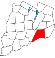
Maryland is a town in Otsego County, New York, United States. The population was 1,897 at the 2010 census. It was named for the U.S. state of the same name. The Town of Maryland is on the county's southern border. It is northeast of the City of Oneonta.

<span class="mw-page-title-main">Wesley Hills, New York</span> Village in New York, United States

Wesley Hills is a village in the town of Ramapo, Rockland County, New York, United States. It is located north of Viola, east of Harriman State Park, south of Pomona, and west of New Hempstead. The population was 5,628 at the 2010 census.

<span class="mw-page-title-main">Old Field, New York</span> Village in New York, United States

Old Field is a village located in the Town of Brookhaven in Suffolk County, on Long Island, in New York, United States. The population was 918 at the 2010 census.

<span class="mw-page-title-main">Woodridge, New York</span> Village in New York, United States

Woodridge is a village in Sullivan County, New York, United States. The population was 847 at the 2010 census. The village is in the town of Fallsburg at the junction of county routes 53, 54, 58, and 158. The Woodridge ZIP Code is 12789.

<span class="mw-page-title-main">West Hurley, New York</span> CDP in New York, United States

West Hurley is a hamlet in Ulster County, New York, United States. The population was 1,917 at the 2020 census.

<span class="mw-page-title-main">Tappen, North Dakota</span> City in North Dakota, United States

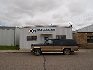
Tappen is a city in Kidder County, North Dakota, United States. The population was 217 at the 2020 census.

<span class="mw-page-title-main">Cooper Township, Montour County, Pennsylvania</span> Township in Pennsylvania, United States

Cooper Township is a township in Montour County, Pennsylvania, United States.

The Town of Spring Valley is located in Rock County, in the U.S. state of Wisconsin. The population was 728 at the 2020 census. The village 0f Orfordville is located within the town.

Delhi is a village in Delaware County, New York, United States. The population was 3,087 at the 2010 census. Delhi is the county seat of Delaware County.

Esperance is a village in Schoharie County, New York, United States. The population was 345 at the 2010 census. The village was given the French name for "hope."

<span class="mw-page-title-main">Richmondville, New York</span> Town in New York, United States

Richmondville is a town in Schoharie County, New York, United States. The population was 2,610 at the 2010 census. The town name was adapted from the name of a post office in its territory.

<span class="mw-page-title-main">Schoharie (village), New York</span> Village in New York, United States

Schoharie is a village in Schoharie County, New York, United States. The population was 922 at the 2010 census. It is the county seat of Schoharie County. The name is a native word for driftwood.

References

  1. "ArcGIS REST Services Directory". United States Census Bureau. Retrieved September 20, 2022.
  2. "National Register Information System". National Register of Historic Places . National Park Service. March 13, 2009.
  3. "US Gazetteer files: 2010, 2000, and 1990". United States Census Bureau. 2011-02-12. Retrieved 2011-04-23.
  4. "Census of Population and Housing". Census.gov. Retrieved June 4, 2015.
  5. "U.S. Census website". United States Census Bureau . Retrieved 2008-01-31.